
TC Watch > Selected TC Review > 200813W (NURI) [Refresh]
 200813W (NURI) - Profile 200813W (NURI) - Profile |
(First issued on September 6th, 2008, final version issued on October 7th, 2008)
Brief profile of NURI:
| JTWC number | 13W |
| International number | 0812 |
| Period of existence | 17 August, 2008 08 HKT to 23 August, 2008 02 HKT |
| Lifetime | 5.75 days |
| Maximum 1-minute wind (JTWC) | 100 knots |
| Minimum pressure (JTWC) | 948 hPa |
| Highest TC signal by HKO (if applicable) | 9 (Increasing Gale or Storm Signal) |
| Closest point of approach by HKO (if applicable) | <1 km (real-time warnings: 1; 2* and TC report) |
| Time of closest approach by HKO (if applicable) | 22 August, 2008 17-18 HKT (real-time warning*) / 22 August, 2008 17:20 HKT (TC report) |
| Lowest pressure recorded at HKO (if applicable) | 982.3 hPa (22 August, 2008 15:46 to 16:12 HKT) |
*The locations of NURI at 17 and 18 HKT are 22.3N 114.3E and 22.3N 114.1E respectively while the location of HKO is at 22.3N 114.2E. All measurements are correct to 1 decimal place.
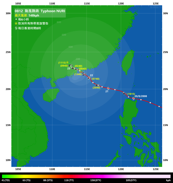
TC signals for Hong Kong & Track:
Table:
Signal |
Date and time |
Distance from HK |
Predicted movement |
Max. 10-min winds |
 |
2008/08/20 (WED) 18:15 HKT |
ESE 760 km |
NW/WNW at 14 km/h |
148 km/h (80 knots, CAT. 1) |
 |
2008/08/21 (THU) 20:40 HKT |
SE 300 km |
WNW at 14 km/h |
121 km/h (65 knots, CAT. 1) |
 |
2008/08/22 (FRI) 07:40 HKT |
SE 160 km |
NW/WNW at 14 km/h |
121 km/h (65 knots, CAT. 1) |
 |
2008/08/22 (FRI) 13:40 HKT |
ESE 40 km |
NW at 14 km/h |
121 km/h (65 knots, CAT. 1) |
 |
2008/08/23 (SAT) 00:40 HKT |
NW 100 km |
NW/WNW at 14 km/h |
103 km/h (55 knots, STS) |
|
2008/08/23 (SAT) 02:40 HKT |
WNW 130 km |
WNW at 14 km/h |
83 km/h (45 knots, TS) |
|
2008/08/23 (SAT) 09:40 HKT |
WNW 190 km |
W at 16 km/h |
56 km/h (30 knots, TD) |
 |
2008/08/23 (SAT) 11:15 HKT |
NW 200 km |
W at 16 km/h |
56 km/h (30 knots, TD) |
Figure: (Track courtesy of Lorenzo. Data from HKO.)
IR imagery animation 紅外線雲圖動畫:
TC track from HKWW:
TC tracks from HKO:


| Past HKWW Bulletins on NURI |
Please click here for bulletins on NURI.
| Storm Formation |
NURI was again a storm (after FENGSHEN) that major agencies failed to predict its movement with an early recurvature that did not realize at all.
Under favorable environment, tropical disturbance 92W in northwestern Pacific Ocean developed into a tropical depression on August 17th. JTWC formally recognized this depression at 08 HKT that day and the depression was given the temporary number 13W. The JMA released gale warning for this system later at 20 HKT the same day, and upgraded it to a tropical storm the next day at 08 HKT, assigning the name NURI which is contributed by Malaysia. For the HKO, it upgraded the system to tropical depression and tropical storm status at 05 and 08 HKT on August 18th respectively.
At that time, the western extension of a subtropical ridge was firmly positioned north of the system, and the ridge was forecast to extend westward in the next two to three days. However, numerical models called for a sharp retreat of the ridge three days later, leading to a NW to N movement later on as depicted in most agencies' initial forecasts.
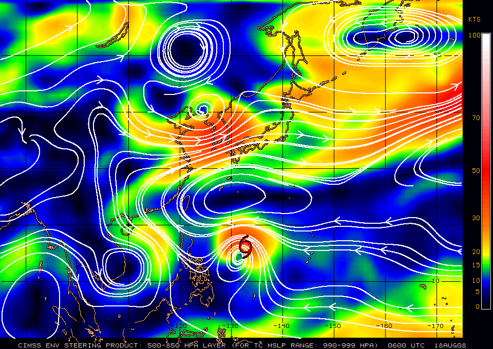
Figure 1 - Steering chart at 14 HKT, August 18th

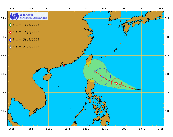

Figures 2a to d - Initlal forecast tracks of NURI by various agencies (JTWC, CWB, HKO and JMA in order)
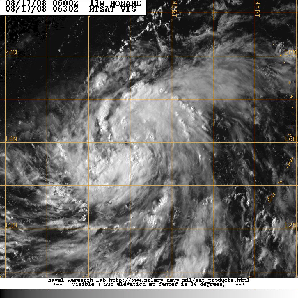
Figure 3 - Image of NURI at 14:30 HKT on August 17th
| Storm Development |
The subtropical ridge remained intact in the next few days, extending westward at the same time which was in agreement with the situation projected by models. Indeed, the 500 hPa geopotential height near the centres of the high pressures remained above 5,900 metres before NURI crossed the Luzon Strait. As this strong ridge was positioned to the north of the system, NURI moved quickly westward to west-northwestward in the next three days, at a speed between 13 and 18 knots (24 and 33 km/h). It skirted past the northern tip of Luzon on August 20th and made its way into the South China Sea.

Figure 4 - Steering chart at 14 HKT, August 20th


Figures 5a to d - Forecast track of NURI by various agencies (JTWC, CWB, HKO and JMA in order) at 14 HKT on August 20th
As for NURI's intensity, it benefited from good equatorward outflow and high water heat content and intensified successively into a severe tropical storm and a typhoon at 20 HKT on August 18th and 02 HKT on August 19th respectively (JMA 10-minute standard). It reached peak intensity as it crossed Luzon Strait as a category 3 typhoon (100 knots [185 km/h] in JTWC 1-minute standard**). NURI caused some damages to the northern provinces of the Philippines; 12 people were killed, 13 injured and 17 went missing as a result of the storm. Widespread heavy rain was observed in the whole Luzon.
** Revised upward from 95 knots.

Figure 6 - NURI at peak intensity
| NURI in the South China Sea and Preparations in Hong Kong |
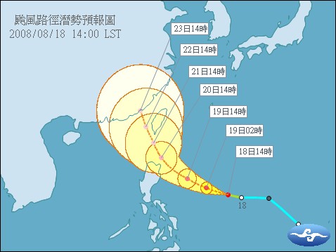
As a result of land interactions with the Philippine terrain, NURI moved nearly due west just before crossing Luzon Strait, and a northwestern movement was observed briefly as it moved into the South China Sea. The ridge started to weaken at this time, and this slowed down NURI's movement. This decelerated NW movement, together with anticipated gradual weakening of the subtropical ridge, prompted agencies to adjust the location of landfall further to the east. However, as land interaction diminished and the strength of the ridge in China was maintained, NURI moved due west again in the small hours on August 21st and agencies subsequently turned their tracks westward, depicting a landfall in the vicinity of Hong Kong in the afternoon forecasts (on August 21st).
As NURI came within 800 km of Hong Kong, the HKO issued the Standby Signal number 1 at 18:15 HKT on August 20th when NURI was 760 km ESE of the territory. Vertical wind shear in the South China Sea has strengthened significantly since NURI neared Luzon due to the diminishing influence of the subtropical ridge. NURI failed to gain strength as predicted earlier, but still it was a significant tropical cyclone that was threatening the South China coast.
NURI's strength fluctuated during the later parts of August 20th and in the morning of August 21st, but eventually succumbed to the strong shear to begin its weakening trend. NURI maintained a stable WNW movement for the rest of August 21st, and the Observatory raised the alert to the Strong Wind Signal number 3 at 20:40 HKT on the same day. This Strong Wind Signal was again deemed precautionary as winds in the territory did not reach strong force levels before August 22nd. Since the HKO started to predict a direct hit, significantly heightened alert was observed among the general public since the afternoon of August 21st. Services at cargo terminal were suspended (Chinese link) and the HKO indicated in the tropical cyclone bulletin that "the chance of the Gale or Storm Signal number 8 cannot be ruled out" but was unlikely during the early morning.


(left) Figure 7 - Vertical wind shear in the South China Sea at 14 HKT, August 21st
(right) Figure 8 - HKO's direct hit prediction at 16 HKT, August 21st

Figure 9 - Forecasts by various agencies, 14 HKT August 21st. The pink and pale red regions indicate 50% (or above) probability of gales in Victoria Harbour for typhoons and severe tropical storms respectively.
Winds picked up after midnight on August 22nd, and by sunrise winds reached strong force in urban areas and gale force on high grounds and in offshore waters. The Observatory issued the Pre-no. 8 Special Announcement at 05:50 HKT when the storm was 190 km SE of Hong Kong, indicating that the number 8 signal would be issued before 08 HKT. Ferry services within the territory and those between Hong Kong and Macau were gradually suspended in the morning and all day schools were also suspended on August 22nd.
The Observatory issued the Number 8 Northwest Gale or Storm Signal at 07:40 HKT when NURI was 160 km SE of Hong Kong, and stated that the chance of a direct hit could not be ruled out.
| Direct Hit on Hong Kong |
Pressure dropped sharply during the morning of August 22nd. Being the closest available station to NURI, Waglan Island's sea level pressure dropped to 989 hPa near 09 HKT and further to 985 hPa at 11 HKT. North to northwesterly winds continued to strengthen in the territory with a direct hit becoming more and more likely. In light of this situation, the Observatory issued the Increasing Gale or Storm Signal number 9 at 13:40 HKT, the first issuance since Typhoon Dujuan in 2003. Storm force winds were recorded at several stations at that time with the storm being 40 km away from the HKO Headquarters. In a media interview with Edwin Ginn, Senior Scientific Officer of the HKO, it was mentioned that the chance of the Hurricane Signal number 10 could not be ruled out if NURI edged closer and maintained intensity.
However real-time wind speed data were not sufficient to support hurricane force winds within Hong Kong at sea level, and thus the HKO downgraded NURI into a severe tropical storm at 17 HKT, literally wiping out the chance of the hurricane signal. In the next hour, NURI turned to a westerly motion and traversed Kowloon from east to west, entering the seas between Hong Kong Island and Tsing Yi. NURI then turned northwestward and approached Tuen Mun at near 20 HKT, and went north into Deep Bay at 21 HKT. It skirted the western part of Shenzhen and crossed the Pearl River estuary to the western coast, weakening gradually in the meantime.
During the passage of NURI, winds subsided in some urban areas but was later on replaced by strong southwesterly winds. Waglan Island (with elevation in excess of 80 m) recorded hurricane force southwesterly winds as NURI moved to northwestern parts of Hong Kong, and Cheung Chau recorded storm force winds. Therefore the number 9 signal was justified as it alerted the public about the rapidly strengthening winds at night.
The following table shows the location of NURI between 14 HKT and 23 HKT on August 22nd (Coordinates extracted from HKO tropical cyclone bulletins):
Time (on August 22nd) |
Coordinates |
Bearing and distance from HKO |
Location |
14 HKT |
22.1N 114.5E |
ESE 40 km |
--- |
15 HKT |
22.3N 114.4E |
E 20 km |
Seas near Sai Kung |
16 HKT |
22.3N 114.4E |
E 20 km |
Seas near Sai Kung |
17 HKT |
22.3N 114.3E |
E 15 km |
Sai Kung |
18 HKT |
22.3N 114.1E |
W 10 km |
Seas between HK Island and Tsing Yi |
19 HKT |
22.3N 114.0E |
W 20 km |
Northeastern corner of Lantau Island |
20 HKT |
22.4N 114.0E |
WNW 20 km |
Tuen Mun |
21 HKT |
22.5N 114.0E |
NW 30 km |
Deep Bay |
22 HKT |
22.6N 113.9E |
NW 40 km |
Western Shenzhen |
23 HKT |
22.7N 113.6E |
NW 70 km |
Northwestern corner of Pearl River estuary |
It is worth noting that if the intermediate positions are linearly interpolated, it will represent a direct hit on the Observatory (22.3N 114.2E correct to 1 decimal place). In HKO's report on Nuri, Nuri passed Tsim Sha Tsui and was closest to the Observatory at 17:20 HKT when it was less than 1 kilometre south of the headquarters.

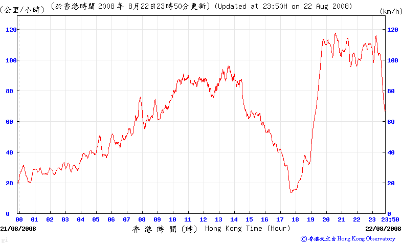

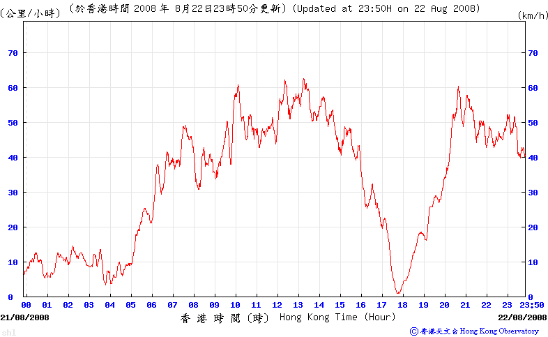

Figures 10a to e - Wind speed time series for Cheung Chau, Green Island, Peng Chau, Tsing Yi (Shell Oil Depot) and Waglan Island respectively
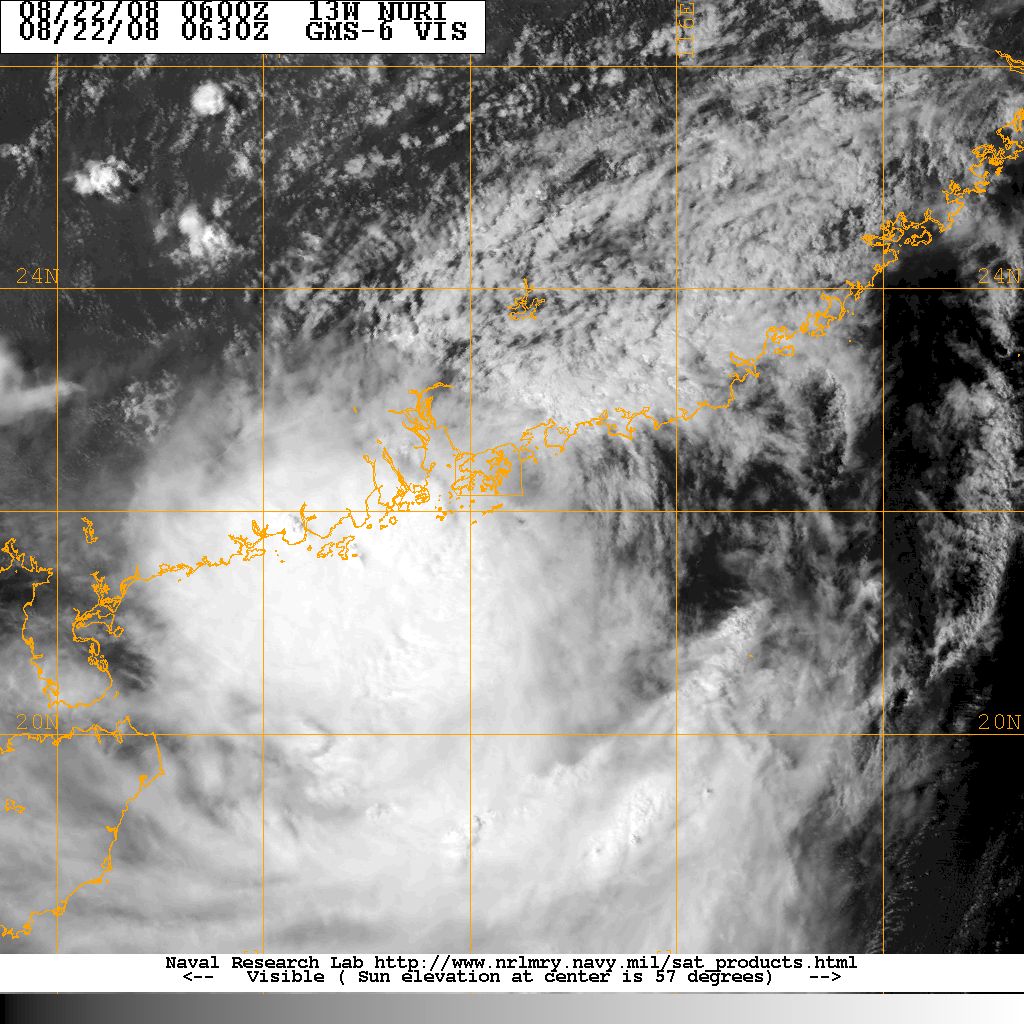
Figure 11 - NURI near landfall at Hong Kong

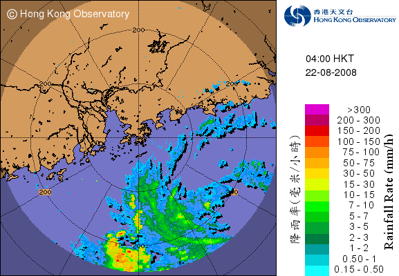


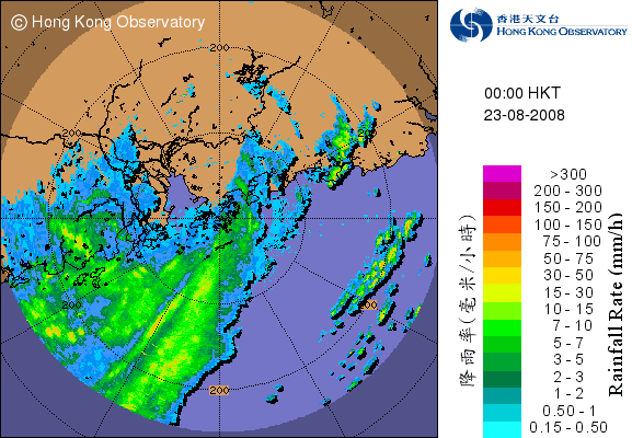
Figures 12a to g - RADAR images from 00 HKT August 22nd to 00 HKT August 23rd at 4-hour intervals.

Figure 13 - NURI's track near Hong Kong

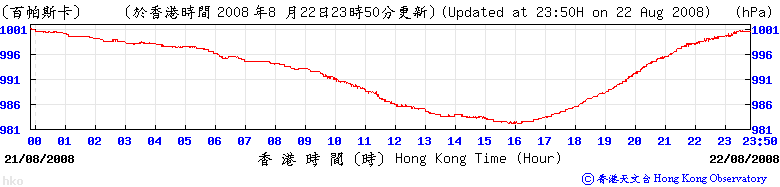

Figures 14a to c - Mean sea level pressure during August 22nd at Cheung Chau, HKO and Waglan Island respectively
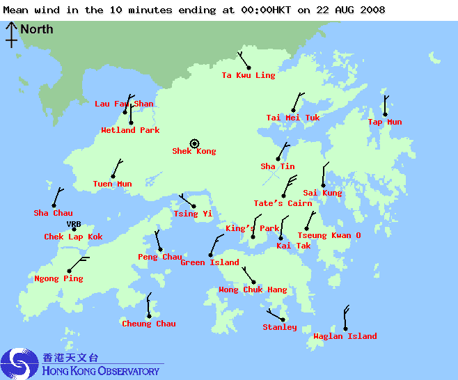


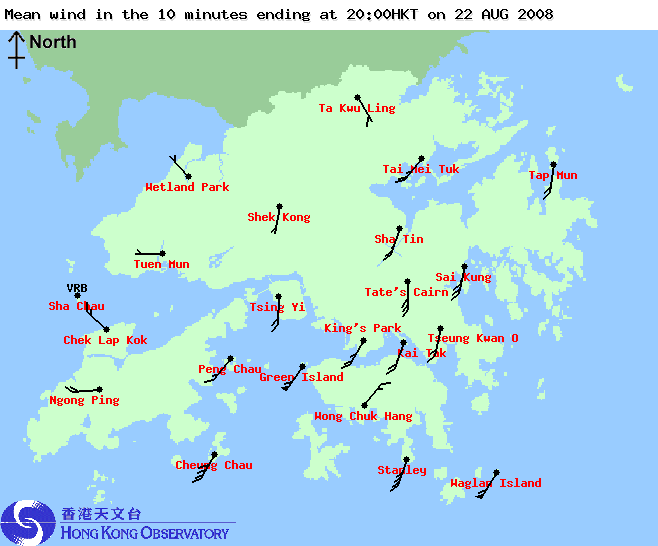
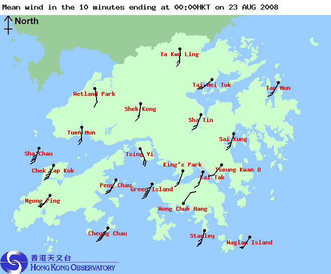
Figures 15a to g - Wind directions and speeds in Hong Kong from 00 HKT August 22nd to 00 HKT August 23rd, at 4-hour intervals.

Figure 16 - Judging from this wind distribution image, the centre of NURI should be very close to the Observatory at 17:10 HKT
| NURI's Weakening and Dissipation |
NURI travelled WNW and skirted Guangzhou near midnight, August 23rd. Due to greatly reduced water content, NURI weakened rapidly and the Observatory downgraded NURI into a tropical storm, tropical depression and finally an area of low pressure at 02 HKT, 09 HKT and 13 HKT respectively.
As for tropical cyclone signals, the Observatory replaced the number 9 signal with the number 8 Southwest Gale or Storm Signal at 00:40 HKT on August 23rd as wind speeds ceased to be "increasing". It was lowered to the Strong Wind Signal number 3 at 02:40 HKT when gales were confined on high grounds and offshore waters. The Standby Signal number 1 was issued at 09:40 HKT as gales faded away in the territory, and all signals were cancelled at 11:15 HKT when NURI no longer posed a threat to Hong Kong.
There are two points that are worth mentioning concerning the approach of NURI:
- NURI made landfall on Hong Kong instead of skirting south of the territory. As the large centre of NURI passed over Hong Kong winds were relatively light. If instead NURI swept past the southern Hong Kong waters, Hong Kong would be affected by the easterly winds in NURI's northern circulation. As most places in Hong Kong are exposed to the east and Hong Kong would then be inside the "dangerous" semicircle of the storm, winds could be considerably higher and the Hurricane Signal might would have been necessary in that case.
- NURI's strongest rainbands were in its southern semicircle. If NURI continued to travel north after traversing Hong Kong those rainbands would approach the territory and the squalls that accompanied the rainbands might push wind speeds much higher than that actually observed as NURI moved into the Pearl River estuary. Therefore in the case of NURI, Hong Kong avoided the dangerous easterly winds when it was approaching, and also avoided the squalls when it was leaving.
| Incidents Related to NURI |
Three issues arose as NURI affected Hong Kong:
-
On August 21st, emails regarding the exact times that different tropical cyclone signals were to be issued spread all over Hong Kong, and SMS's about the same information were sent throughout the territory. The message was, of course, fake and the Observatory stated that they did not release anything of this kind to any organization. They advised the public to refer to official reports disseminated through radio stations, TV stations and the Observatory's website. [Link to the relevant news (in Chinese)]

Figure 17 - The fake SMS message
- The use of the word "qingchen" (lit. "clear morning") to represent times in the region between 1 a.m. and 5 a.m. The word "qingchen" in Chinese has evolved from meaning the early hours after midnight to representing times near sunrise, and therefore ambiguity exists and people may interpret this word in different ways. The Observatory has therefore agreed to abandon this word together with the English counterpart "early morning", and will use the word "lingchen" in Chinese and "in the small hours" in English to represent times between midnight and sunrise. Please click the following links to read more on this:
- HKO-Director's Blog (published on September 1st, 2008): Chinese | English
- RTHK news report: Chinese only
- Several pictures that claimed to be the "eye" of NURI were taken by enthusiasts in the eastern part of Hong Kong when NURI passed in its vicinity. However, as NURI was not a strong system and its centre was very unclear and cloud-filled in satellite imageries as it approached Hong Kong, it would be better to describe the blue sky in those photos a clear region within the centre, and it would be technically unsuitable to describe it as an eye. Nevertheless, NURI was one of the strongest systems that crossed Hong Kong in the daytime since 2000, and the rarity of such photos have prompted the Observatory to include one in its tropical cyclone report. [Link to the relevant news (in Chinese, accessible using HK IP addresses only)]
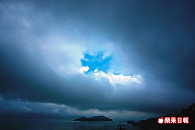
Figure 18 - Blue "eye" within the centre of NURI (click on the above link for the news article from Apple Daily)
| Charts and Figures |
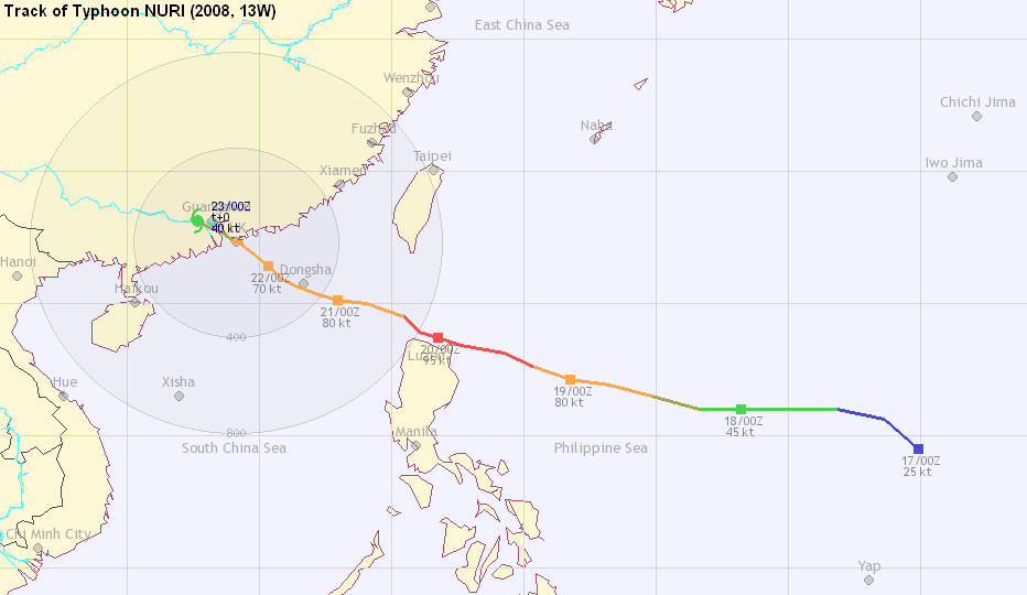
Table 1: Track data from HKWW:
YYMMDDZZ Lat Long Wind |
Table 2: Maximum gust and 60-minute average wind speed recorded in Hong Kong from HKO:
| Station | Maximum Gust | Maximum Hourly Wind | ||||||
| Direction | Speed (km/h) | Date/Month | Time | Direction | Speed (km/h) | Date/Month | Time | |
| Bluff Head (Stanley) | SSW | 118 | 22/8 | 19:54 | SSW | 75 | 22/8 | 20:00 |
| Central Pier | WNW | 90 | 22/8 | 11:44 | NW | 43 | 22/8 | 12:00 |
| Cheung Chau | SSW | 126 | 22/8 | 22:18 | SSW | 88 | 22/8 | 23:00 |
| Cheung Sha Wan | SW | 96 | 23/8 | 00:10 | SW | 54 | 22/8 | 21:00 |
| Green Island | SSW | 144 | 22/8 | 23:06 | SW | 110 | 22/8 | 21:00 |
| Hong Kong International Airport | SSW | 112 | 23/8 | 01:11 | SSW | 76 | 23/8 | 01:00 |
| Kai Tak | N | 118 | 22/8 | 13:08 | N | 47 | 22/8 | 13:00 |
| King's Park | NNE | 118 | 22/8 | 10:51 | SSW | 49 | 22/8 | 21:00 |
| Lau Fau Shan | N | 92 | 22/8 | 08:28 | N | 49 | 22/8 | 09:00 |
| Ngong Ping | SW | 196 | 22/8 | 23:31 | SW | 128 | 23/8 | 01:00 |
| North Point | NNE | 110 | 22/8 | 12:02 | NNE | 54 | 22/8 | 14:00 |
| Peng Chau | N | 112 | 22/8 | 10:32 | NNW | 62 | 22/8 | 12:00 |
| NNW | 62 | 22/8 | 14:00 | |||||
| Ping Chau | ENE | 108 | 22/8 | 13:32 | E | 34 | 22/8 | 15:00 |
| Sai Kung | NNE | 148 | 22/8 | 13:33 | NNE | 87 | 22/8 | 14:00 |
| Sha Chau | NNW | 128 | 22/8 | 12:36 | N | 94 | 22/8 | 15:00 |
| SSW | 128 | 23/8 | 01:12 | |||||
| Sha Lo Wan | SW | 135 | 23/8 | 01:10 | SW | 65 | 23/8 | 02:00 |
| Sha Tin | SW | 101 | 22/8 | 21:27 | SSW | 45 | 22/8 | 21:00 |
| Shek Kong | NNE | 76 | 22/8 | 14:10 | N | 38 | 22/8 | 15:00 |
| Star Ferry (Kowloon) | WSW | 104 | 22/8 | 20:00 | S | 34 | 22/8 | 21:00 |
| SW | 104 | 22/8 | 21:12 | |||||
| Ta Kwu Ling | NNE | 87 | 22/8 | 13:26 | N | 40 | 22/8 | 14:00 |
| Tai Mei Tuk | SW | 144 | 22/8 | 20:25 | NE | 79 | 22/8 | 14:00 |
| Tai Mo Shan | SSW | 144 | 22/8 | 20:53 | N | 96 | 22/8 | 13:00 |
| Tap Mun | NE | 121 | 22/8 | 13:33 | NE | 62 | 22/8 | 14:00 |
| Tate's Cairn | N | 193 | 22/8 | 13:45 | N | 122 | 22/8 | 14:00 |
| Tsak Yue Wu | NNE | 106 | 22/8 | 11:48 | NNE | 45 | 22/8 | 12:00 |
| Tseung Kwan O | N | 90 | 22/8 | 12:08 | N | 31 | 22/8 | 13:00 |
| Tsing Yi Shell Oil Depot | NNW | 101 | 22/8 | 10:06 | NNW | 56 | 22/8 | 13:00 |
| Tuen Mun Government Offices | SSW | 96 | 23/8 | 02:39 | S | 36 | 23/8 | 01:00 |
| S | 36 | 23/8 | 02:00 | |||||
| Waglan Island | SSW | 157 | 22/8 | 19:32 | SSW | 115 | 22/8 | 20:00 |
| Wetland Park | N | 94 | 22/8 | 12:08 | N | 41 | 22/8 | 14:00 |
| Wong Chuk Hang | N | 88 | 22/8 | 11:32 | NNW | 31 | 22/8 | 13:00 |
Table 3: Rainfall contributed by NURI from HKO (figures in brackets are based on incomplete hourly data):
| Station | 20 Aug | 21 Aug | 22 Aug | 23 Aug | Total | |
| Hong Kong Observatory | 0.0 | Trace | 61.6 | 36.9 | 98.5 | |
| Cheung Chau (CCH) | 0.0 | 0.0 | 34.5 | 15.0 | 49.5 | |
| Hong Kong International Airport (HKA) | 0.0 | Trace | 69.8 | 34.9 | 104.7 | |
| H12 | Mid Levels | [0.0] | [0.0] | [47.0] | [39.0] | [86.0] |
| H19 | Shau Kei Wan | 0.0 | 0.0 | 53.0 | 38.0 | 91.0 |
| H21 | Repulse Bay | 0.0 | 0.0 | 20.5 | 29.5 | 50.0 |
| K04 | Jordan Valley | [0.0] | [0.0] | [56.5] | [29.5] | [86.0] |
| K06 | So Uk Estate | [0.0] | [0.0] | [51.0] | [26.0] | [77.0] |
| N05 | Fanling | 0.0 | 0.0 | 21.5 | 23.0 | 44.5 |
| N06 | Kwai Chung | 0.0 | 0.0 | 49.0 | 35.0 | 84.0 |
| N09 | Sha Tin | [0.0] | [0.0] | [58.0] | 36.5 | [94.5] |
| N12 | Yuen Long | 0.0 | 0.0 | 26.0 | 20.0 | 46.0 |
| N13 | High Island | 0.0 | 0.0 | 40.5 | 24.0 | 64.5 |
| N17 | Tung Chung | 0.0 | 0.0 | 106.0 | 66.5 | 172.5 |
| R21 | Tap Shek Kok | 0.0 | 5.5 | 26.0 | 19.5 | 51.0 |
| R26 | Shek Kong | 0.0 | 0.0 | 33.5 | 18.5 | 52.0 |
| R31 | Tai Mei Tuk | 0.0 | 0.0 | 35.0 | 15.0 | 50.0 |
Last Accessed: Tue Apr 16 2024 20:29:02 HKT
Last Modified: Mon Jul 24 2023
