
TC Watch > Selected TC Review > 200818W (HAGUPIT) [Refresh]
 200818W (HAGUPIT) - Profile 200818W (HAGUPIT) - Profile |
(First issued on October 7th, 2008, final version issued on October 24th, 2008)
Brief profile of HAGUPIT:
| JTWC number | 18W |
| International number | 0814 |
| Period of existence | 19 September, 2008 02 HKT to 24 September, 2008 20 HKT |
| Lifetime | 5.75 days |
| Maximum 1-minute wind (JTWC) | 120 knots |
| Minimum pressure (JTWC) | 933 hPa |
| Highest TC signal by HKO (if applicable) | 8 (Gale or Storm Signal, directions: NE and SE in order) |
| Closest point of approach by HKO (if applicable) | SSW 180 km (real-time warning and TC report) |
| Time of closest approach by HKO (if applicable) | 23 September, 2008 22 HKT (real-time warning) / 22-23 HKT (TC report) |
| Lowest pressure recorded at HKO (if applicable) | 992.2 hPa (23 September, 2008 17:49 to 18:57 HKT) |
TC signals for Hong Kong & Track:
Table:
Signal |
Date and time |
Distance from HK |
Predicted movement |
Max. 10-min winds |
 |
2008/09/22 (MON) 18:40 HKT |
ESE 790 km |
W/WNW at 30 km/h |
157 km/h (85 knots, CAT. 2) |
 |
2008/09/23 (TUE) 10:25 HKT |
SE 380 km |
W/WNW at 28 km/h |
176 km/h (95 knots, CAT. 2) |
 |
2008/09/23 (TUE) 18:00 HKT |
SSE 210 km |
W/WNW at 28 km/h |
176 km/h (95 knots, CAT. 2) |
 |
2008/09/24 (WED) 00:40 HKT |
SW 200 km |
W/WNW at 28 km/h |
176 km/h (95 knots, CAT. 2) |
|
2008/09/24 (WED) 06:30 HKT |
WSW 330 km |
W/WNW at 28 km/h |
176 km/h (95 knots, CAT. 2) |
 |
2008/09/24 (WED) 12:50 HKT |
W 460 km |
W/WNW at 16 km/h |
130 km/h (70 knots, CAT. 1) |
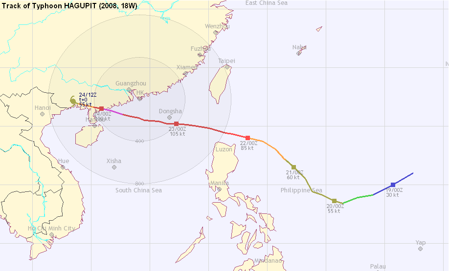
Figure: (Track courtesy of Lorenzo. Data from HKO.)

IR imagery animation 紅外線雲圖動畫:
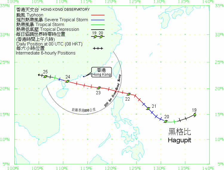
TC track from HKWW:
TC tracks from HKO:

| Past HKWW Bulletins on HAGUPIT |
Please click here for bulletins on HAGUPIT.
| Storm Formation and Development |
HAGUPIT was the strongest cyclone to enter the South China Sea and to make landfall in Southern China so far this year.
An area of low pressure persisted to the east of Philippines in mid-September. This disturbance slowly organized and was upgraded to a tropical depression by various agencies on early September 19th, and the JTWC gave the storm the temporary number 18W. At that time a strong subtropical ridge was situated to the north of the system, which was expected to weaken and re-strengthen again later to allow a WNW to NW motion throughout. This forecast track resembled those "classic tracks" that crossed Luzon Strait and had a major impact on Hong Kong.
Shear was light at that time. Together with very warm seas with sufficient moisture, 18W organized itself into a tropical storm later that day and the JMA named it HAGUPIT at 20 HKT, a name contributed by the Philippines which means "to lash". This is the second storm name that necessitated tropical cyclone warning signals from the HKO twice in the two cyclones that was assigned this name (the first time the name "HAGUPIT" was used was in September 2002), the first being KAMMURI (affected Hong Kong in August 2002 and August 2008). At this time, most agencies were predicting a landfall much east of Hong Kong, but as it turned out the subtropical ridge was stronger than expected and westward shifts were made almost bulletin by bulletin.

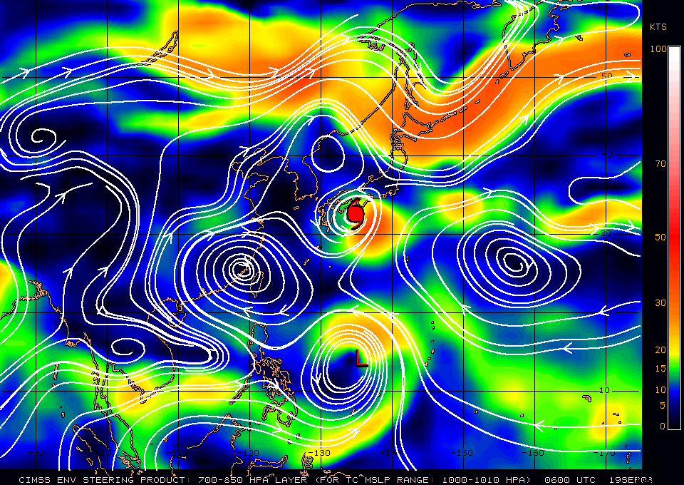
Figures 1 and 2 - Satellite image of HAGUPIT at 14:30 HKT on September 19 (left); Steering chart at 14 HKT, September 19th (right)

Figure 3 - Initial forecast tracks by various agencies
| Approaching Luzon Strait |
HAGUPIT moved west-southwestward on September 19th and early 20th, but resumed a NW track in response to a slight weakness induced in the subtropical ridge by a passing mid-latitude trough. As outflow continued to improve, the JMA upgraded HAGUPIT into a severe tropical storm at 08 HKT on September 20th, and the HKO followed suit at noon. Intensification slowed down at this point, and it was not until late September 21st that HAGUPIT was upgraded into a typhoon.
In light of the approach of HAGUPIT, the CWB of Taiwan issued the "sea warning for typhoon" at 14:30 HKT on September 21st, and upgraded it to a "land warning" 12 hours later.
After the passage of the weak trough, the subtropical ridge re-strengthened again and HAGUPIT turned to a WNW direction early September 22nd. At that time HAGUPIT's centre has passed 18.5 degrees north and therefore it was able to traverse Luzon Strait without touching any major landmass. The effect of HAGUPIT on Taiwan was not as severe as predicted as the subtropical ridge remained stronger than forecast (HAGUPIT was originally predicted to enter Luzon Strait at a higher latitude of 20+ degrees north). Intensification resumed and a round eye was developed; HAGUPIT's strength was estimated to be 80 knots by the HKO, 85 knots by the JMA and 90 knots by the JTWC (1-min average) at 14 HKT on September 22nd.


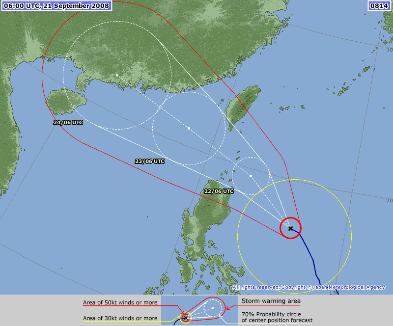
Figures 4a to 4d - Direct hit forecast by various agencies (HKO, CWB, JMA and JTWC in order)

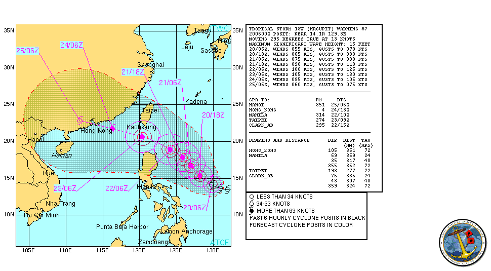
Figure 5 - HAGUPIT crossing Luzon Strait at a strength of 90 knots (JTWC)
| HAGUPIT in South China Sea and Conditions in Hong Kong |
Affected by HAGUPIT's subsidence, Hong Kong experienced hazy and very hot weather on September 22nd. Temperatures in most parts of the territory reached 34 degrees, with a number of places reaching 36 degrees or higher. The intensity of the haze and the rise in temperature showed that HAGUPIT was a strong system associated with heavy subsidence.
As a fast-moving system, the HKO issued the Number 1 Standby Signal as soon as it came within 800 km from Hong Kong at 18:40 HKT (the distance from Hong Kong, at the instant of issuance, was 790 km). The Observatory mentioned explicitly in its tropical cyclone report that HAGUPIT was a fast-moving system and was a mature typhoon, and that the Number 3 Strong Wind Signal may be necessary during day time the day after (September 23rd).
HAGUPIT travelled steadily west-northwestward and the Observatory issued the Number 3 Strong Wind Signal at 10:25 HKT on September 23rd, and added that they would consider the need for higher signals near dusk that day. Services at cargo terminal were gradually suspended after noon and the HKO announced for the first time a specified time period for considering the Number 8 Signal, namely between 16 HKT and 20 HKT.
Winds picked up gradually in the afternoon and Waglan Island first recorded gale force winds (10-min average) shortly after 14 HKT. The HKO issued the pre-no. 8 special announcement at 16 HKT, indicating the Number 8 Signal would be issued before 18 HKT. Wind speeds rose much more significantly after the issuance of the pre-no. 8 announcement, and Waglan Island recorded storm force winds just shortly afterwards. Ferry services were suspended near sunset.
The Number 8 Northeast Gale or Storm Signal was issued at 18 HKT when HAGUPIT was 210 km SSE of Hong Kong, but was deemed a bit late or "nowcast" in the local community as winds were already very strong in offshore waters like Cheung Chau (66 km/h), Sai Kung and Peng Chau (both 63 km/h). Waglan Island was blowing northeasterly winds at 104 km/h at 17:40 HKT. Since HAGUPIT was a strong typhoon (90 knots by the JMA, 95 knots by the HKO and 105 knots by the JTWC) and was expected to remain over water for quite some period, the HKO added in their report that the Number 8 Signal would remain in force overnight.
HAGUPIT was closest to Hong Kong at 22 HKT that night when it was situated 180 km SSW of the Observatory. Winds were strongest near midnight, with 10-minute sustained winds reaching hurricane force at Tate's Cairn and Ngong Ping; storm force at Cheung Chau, Ping Chau, Tai Mei Tuk and Waglan Island; gale force at 7 stations including Kai Tak and Sai Kung; and strong force in 6 urban stations during the hour from 22:31 HKT to 23:30 HKT on September 23rd.
As HAGUPIT passed to the south of Hong Kong, wind direction turned clockwise from northeast to southeast at around midnight, and the Observatory replaced the northeast signal by the southeast one at 00:40 HKT on September 24th. Due to the incidence of high tide, the Observatory warned against flooding in low-lying areas including Sheung Wan. The Observatory also mentioned that the signal would be in force till at least 06 HKT the same day, which was the first time that the HKO mentioned exact timing in their tropical cyclone reports.

Figure 15 - Hazy weather on September 22nd (image from Apple Daily)

Figure 6 - HAGUPIT's track between September 23rd and 24th

Figure 7 - Wind field calculated as of 20 HKT on September 23rd. Note that the gale force field (>35 knots) encompassed the whole Hong Kong while the Lantau Island was estimated to be situated within the storm force field (>50 knots)
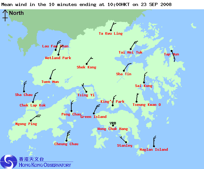


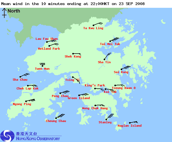
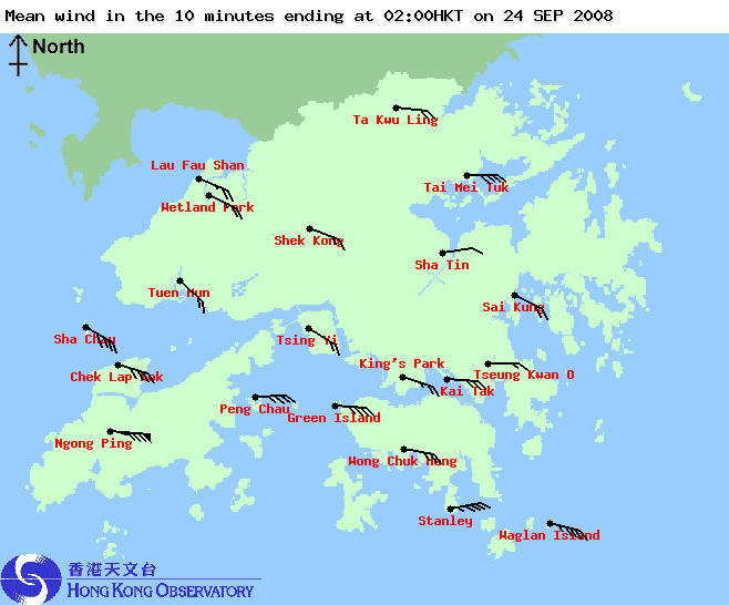

Figures 8a to 8f - Wind speed and direction in Hong Kong, at 4-hour intervals from 10 HKT on September 23rd to 06 HKT on September 24th.


Figures 9a to 9f - RADAR images at 4-hour intervals from 10 HKT on September 23rd to 06 HKT on September 24th. Note the excellent structure of the eyewall.

Figure 10 - Pressure reading at Waglan Island on September 23rd


Figures 11a to 11c - Wind speed data on September 23rd at Cheung Chau, Waglan Island and Stanley

Figure 12a - Colour enhanced infra-red image of HAGUPIT at its closest point of approach (CPA) to Hong Kong
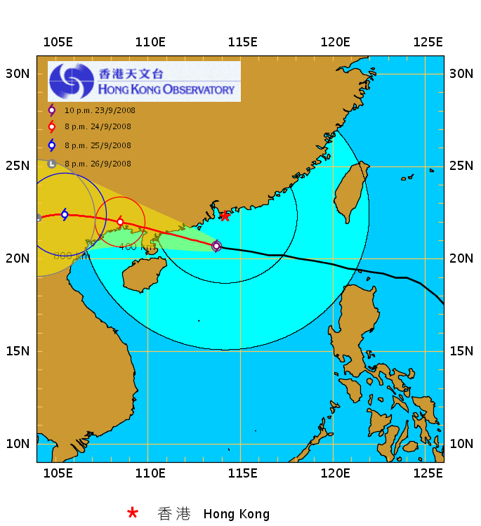
Figure 12b - Track of HAGUPIT at CPA to Hong Kong
| Making Landfall in Western Guangdong and Weakening Trend |
Wind speeds dropped during the early hours of September 26th and the Observatory decided to replace the signal between 06 and 07 HKT. Due to adverse weather conditions the Education Bureau (EDB) suspended all whole-day and morning schools at 05:30 HKT. The Number 3 Strong Wind Signal was issued at 06:30 HKT when the storm was about 330 km WSW of Hong Kong. HAGUPIT made landfall in Dianbai (電白) at about 06:45 HKT; the strength given by the JTWC was 120 knots (category 4). It was very unusual as the storm could keep its intensifying trend in the South China Sea till the moment of landfall. The Chinese authorities mentioned HAGUPIT as the strongest typhoon to make landfall in Guangdong in 12 years (after Typhoon Sally in 1996).
As the Number 8 Signal was cancelled, traffic in Hong Kong resumed near 07 HKT. Later in the morning HAGUPIT's rainband swept past Hong Kong and the Observatory issued the Amber Rainstorm Warning Signal at 11:05 HKT. The EDB announced at around 11 HKT that all schools would be suspended for the rest of the day as weather conditions were still poor. As winds in Hong Kong subsided, the Number 3 Signal was cancelled at 12:50 HKT. The Amber Rainstorm Warning was in force for a longer duration until 16:20 HKT as rain continued in the region near noon and in early afternoon.

Figure 13 - HAGUPIT at maximum intensity (JTWC: 120 knots)
| Major Damage in Hong Kong Caused by HAGUPIT |
Apart from flight delays, Tai O was severely affected by flooding with water reaching chest in the early hours of September 24th, the most serious flooding there in 60 to 70 years. One resident even reported water reaching the bed while sleeping. Authorities said that no problems were found in the drainage system and the flooding was caused by the impact of high tides. Meanwhile, foundations of some houses in Cheung Chau were damaged as sand was removed by waves. 58 people were reported to have injured in Hong Kong as a result of the storm. However, out of expectation, flooding-prone Wing Lok Street in Sheung Wan was spared from major damage this time with only two inches of water on the street.
Although HAGUPIT was a powerful typhoon, its relatively far CPA kept Hong Kong from suffering catastrophic damage. Should HAGUPIT was 100 km closer to Hong Kong, not only the terminal signal (Number 10) would be needed, the damage could be far worse than that during Typhoon YORK in 1999.

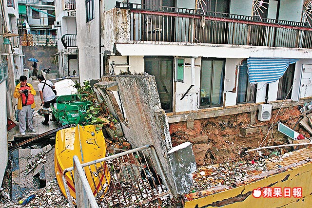
Figures 14a and 14b - Scenes at Tai O and Cheung Chau after the passage of HAGUPIT (images from Apple Daily)
| Charts and Figures |
Table 1: Track data from HKWW:
YYMMDDZZ Lat Long Wind |
Table 2: Maximum gust and 60-minute average wind speed recorded in Hong Kong from HKO:
| Station | Maximum Gust | Maximum Hourly Wind | ||||||
| Direction | Speed (km/h) | Date/Month | Time | Direction | Speed (km/h) | Date/Month | Time | |
| Bluff Head (Stanley) | NE | 131 | 23/9 | 18:55 | E | 77 | 24/9 | 02:00 |
| Central Pier | ENE | 118 | 23/9 | 19:55 | E | 76 | 23/9 | 23:00 |
| Cheung Chau | NE | 153 | 23/9 | 22:40 | - | 108 | 24/9 | 02:00 |
| Cheung Sha Wan | ENE | 133 | 23/9 | 22:08 | ENE | 40 | 23/9 | 23:00 |
| Green Island | NE | 157 | 23/9 | 20:55 | NNE | 70 | 23/9 | 17:00 |
| Hong Kong International Airport | E | 121 | 23/9 | 22:53 | E | 76 | 24/9 | 03:00 |
| Kai Tak | ENE | 131 | 24/9 | 00:19 | E | 54 | 24/9 | 00:00 |
| King's Park | NE | 112 | 23/9 | 20:22 | ESE | 49 | 24/9 | 02:00 |
| Lau Fau Shan | E | 112 | 23/9 | 22:55 | E | 59 | 23/9 | 23:00 |
| Ngong Ping | E | 194 | 24/9 | 01:47 | E | 148 | 24/9 | 02:00 |
| North Point | E | 130 | 23/9 | 21:30 | E | 65 | 23/9 | 23:00 |
| Peng Chau | ENE | 137 | 23/9 | 22:14 | ENE | 90 | 23/9 | 23:00 |
| Ping Chau | E | 101 | 23/9 | 21:19 | E | 45 | 23/9 | 21:00 |
| Sai Kung | ENE | 117 | 23/9 | 19:41 | ENE | 72 | 23/9 | 22:00 |
| Sha Chau | SE | 115 | 24/9 | 02:30 | ESE | 77 | 24/9 | 03:00 |
| Sha Lo Wan | ENE | 126 | 23/9 | 23:54 | E | 70 | 23/9 | 23:00 |
| Sha Tin | NE | 96 | 23/9 | 21:59 | ENE | 34 | 23/9 | 23:00 |
| Shek Kong | ESE | 103 | 23/9 | 23:09 | E | 52 | 24/9 | 01:00 |
| Star Ferry (Kowloon) | E | 108 | 23/9 | 23:21 | E | 62 | 24/9 | 01:00 |
| Ta Kwu Ling | ENE | 88 | 23/9 | 22:29 | E | 38 | 24/9 | 03:00 |
| E | 38 | 24/9 | 04:00 | |||||
| Tai Mei Tuk | ENE | 137 | 23/9 | 22:42 | ENE | 96 | 23/9 | 23:00 |
| Tai Mo Shan | E | 173 | 23/9 | 22:57 | E | 113 | 24/9 | 01:00 |
| Tate's Cairn | - | 171 | 23/9 | 19:17 | - | 110 | 23/9 | 23:00 |
| Tsak Yue Wu | E | 77 | 24/9 | 00:42 | NE | 25 | 23/9 | 18:00 |
| ESE | 77 | 24/9 | 03:03 | |||||
| Tseung Kwan O | NE | 101 | 23/9 | 18:10 | NNE | 36 | 23/9 | 18:00 |
| Tsing Yi Shell Oil Depot | ESE | 99 | 24/9 | 01:53 | ESE | 40 | 24/9 | 00:00 |
| ESE | 40 | 24/9 | 02:00 | |||||
| Tuen Mun Government Offices | SE | 101 | 24/9 | 02:21 | SE | 36 | 24/9 | 04:00 |
| Waglan Island | ENE | 139 | 23/9 | 21:59 | NE | 108 | 23/9 | 19:00 |
| Wetland Park | E | 103 | 23/9 | 22:49 | E | 43 | 23/9 | 23:00 |
| Wong Chuk Hang | SE | 126 | 23/9 | 23:23 | ESE | 58 | 24/9 | 01:00 |
Table 3: Rainfall contributed by HAGUPIT from HKO (figures in brackets are based on incomplete hourly data):
| Station | 22-Sep | 23-Sep | 24-Sep | Total | |
| Hong Kong Observatory | 0.0 | 34.1 | 43.7 | 77.8 | |
| Cheung Chau (CCH) | 0.0 | [13.0] | 106.5 | [119.5] | |
| Hong Kong International Airport (HKA) | 0.0 | 38.8 | 110.8 | 149.6 | |
| H12 | Mid Levels | [0.0] | [36.5] | [88.0] | [124.5] |
| H19 | Shau Kei Wan | 0.0 | 32.0 | 11.0 | 43.0 |
| H21 | Repulse Bay | 0.0 | 40.0 | 33.0 | 73.0 |
| K04 | Jordan Valley | [0.0] | [15.0] | [40.0] | [55.0] |
| K06 | So Uk Estate | [0.0] | [11.0] | [17.0] | [28.0] |
| N05 | Fanling | 0.0 | [0.0] | 48.0 | [48.0] |
| N06 | Kwai Chung | 0.0 | 30.0 | 83.5 | 113.5 |
| N09 | Sha Tin | [0.0] | 30.5 | 23.0 | [53.5] |
| N12 | Yuen Long | 0.0 | 47.0 | 63.5 | 110.5 |
| N13 | High Island | 0.0 | [22.5] | [8.0] | [30.5] |
| N17 | Tung Chung | 0.0 | 38.5 | 135.5 | 174.0 |
| R21 | Tap Shek Kok | 0.0 | 32.5 | 124.0 | 156.5 |
| R26 | Shek Kong | 0.0 | [43.5] | [111.5] | [155.0] |
| R31 | Tai Mei Tuk | 0.0 | 11.5 | 12.5 | 24.0 |
Last Accessed: Sat Apr 20 2024 06:48:04 HKT
Last Modified: Mon Jul 24 2023
