
TC Watch / 熱帶氣旋 > Selected TC Review / 重要熱帶氣旋回顧 > 200915W (CHOI-WAN 彩雲) [Refresh 更新]
 200915W (CHOI-WAN 彩雲) - Profile 檔案 200915W (CHOI-WAN 彩雲) - Profile 檔案 |
(Iissued on October 10th, 2009)
(於 2009 年 10 月 10 日發出)
Brief profile of CHOI-WAN 彩雲小檔案:
| JTWC number 聯合颱風警報中心 (JTWC) 號碼 | 15W |
| International number 國際編號 | 0914 |
| Period of existence 生存時期 (JTWC) | 12 September, 2009 08 HKT to 20 September, 2009 08 HKT |
| Lifetime 壽命 (JTWC) | 8.00 days 日 |
| Maximum 1-minute wind (JTWC) JTWC 一分鐘平均最高中心風速 | 140 knots 節 (Category 5 Super Typhoon 五級超級颱風) |
| Minimum pressure (JTWC) JTWC 最低氣壓 | 918 hPa 百帕 |
| Highest TC signal by HKO (if applicable) 香港天文台發出最高熱帶氣旋警告信號 |
N/A 不適用 |
| Closest point of approach by HKO (if applicable) 香港天文台所示之最接近距離 (如適用) |
N/A 不適用 |
| Time of closest approach by HKO (if applicable) 香港天文台所示之最接近時間 (如適用) |
N/A 不適用 |
| Lowest pressure recorded at HKO (if applicable) 香港天文台錄得的最低氣壓 (如適用) |
N/A 不適用 |
TC track from HKWW 本站的熱帶氣旋路徑圖:
| Past HKWW Bulletins on CHOI-WAN 本站有關彩雲的發佈 |
Please click here for bulletins on CHOI-WAN. 請按這裡。
| Storm Summary 氣旋摘要 |
CHOI-WAN is the first super typhoon and category 5 tropical cyclone in 2009.
A disturbance east of 150°E intensified into tropical depression status on September 12, and the JTWC assigned the number 15W to this system. Since its formation model outputs and forecast tracks from official agencies have converged to the resolution that this system was to recurve along a weakness that was expected to develop within the subtropical ridge.
15W developed quickly in a generally favourable environment, and the JMA upgraded it into a tropical storm in its bulletin for 02 HKT on September 13, naming it CHOI-WAN. This name was contributed by Hong Kong, meaning (literally) colourful clouds in Chinese; it is also the name of a housing estate in Hong Kong. CHOI-WAN moved west in the next 24 hours, and its spiraling cloud bands tightened that day. It was upgraded by the JMA into a severe tropical storm at 02 HKT on September 14. As an eye developed near its centre, typhoon status was reached just 6 hours afterwards, at 08 HKT the same day. [The JTWC upgraded CHOI-WAN into a typhoon at 02 HKT, as it was using the 1-minute average standard]
CHOI-WAN turned northwest shortly after intensifying into a typhoon as the ridge to the north started to weaken. Saipan was spared from major damage as a result. Meanwhile, CHOI-WAN continued to deepen with a growing central dense overcast around the eye. A little more than a day afterwards the JTWC upgraded CHOI-WAN into a super typhoon with sustained winds of 240 km/h (130 knots) near its centre. At the same time, the JMA indicated that CHOI-WAN was packing winds of 175 km/h (95 knots), also close to the maximum during CHOI-WAN's existence.
CHOI-WAN resumed a west-northwestward track on September 15. Category 5 status was reached at 02 HKT on September 16, when CHOI-WAN was situated at 18.2°N 144.2°E, some 740 km (400 NM) south-southeast of Iwo Jima, with a central pressure of 918 hPa. The JMA, meanwhile, determined that CHOI-WAN was packing sustained winds of 185 km/h (100 knots) with pressure 915 hPa. Super typhoon status was also given by the CMA [CMA gave a maximum of 65 m/s (234 km/h, 126 knots) in 2-minute average standard. Also note that "super typhoon" in CMA has different meaning. See TC Classification for more].
The subtropical ridge separated into two halves later on September 16, and CHOI-WAN started to move in a more poleward direction. It remained as a category 5 typhoon for 30 hours, and as cloud-top temperatures of the eyewall started to rise the JTWC adjusted its intensity downward at 08 HKT on September 17. The JMA also withheld the strength of 100 knots 6 hours afterwards.
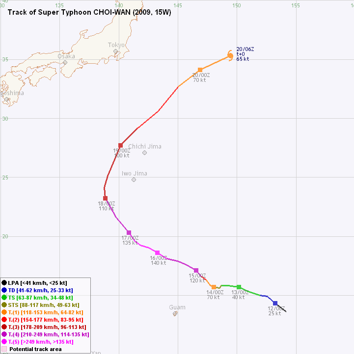
CHOI-WAN passed 140°E longitude at about 17 HKT that day, entering the area within which the HKO will mention the system and issue forecast tracks. It was also the first time that "super typhoon" was used as the strength of an existing tropical cyclone in the weather bulletin at 19:45 HKT that night since the implementation of such a classification system earlier this year. It was later revealed that the HKO assigned a wind speed of 210 km/h (113 knots) to CHOI-WAN at 20 HKT that day.
As environment deteriorated, CHOI-WAN's eyewall cloud-top temperatures continued to rise, and an eyewall replacement cycle began. The double eyewall feature was seen on September 18 with spiraling bands diminishing in the periphery. By then, CHOI-WAN had already crossed the ridge axis and started to move in a north-northeasterly direction. CHOI-WAN's track speed increased as it was influenced by the westerlies, and extratropical transition started in late September 19. CHOI-WAN's eye disintegrated and the system became an extratropical cyclone on September 20.
彩雲為 2009 年度首個五級超級颱風。
一個於東經 150 度以東的熱帶擾動於 9 月 12 日增強為熱帶低氣壓,JTWC 給予臨時編號 15W。從 15W 形成起,數值預報模式和各官方路徑已大致相同,皆為預料副熱帶高壓脊將退卻並令 15W 於副高弱點轉向。
15W 於良好環境中快速發展,JMA (日本氣象廳) 於 13 日上午 2 時的發佈中把其升格為熱帶風暴,並命名為彩雲。此名稱由香港提供,為本港一屋邨的名稱。彩雲於其後 24 小時向偏西方向移動,而其螺旋雲帶逐漸變得緊密。JMA 於 14 日上午 2 時升格彩雲為強烈熱帶風暴,而隨著彩雲於稍後發展出一風眼,它於 6 小時後 (即上午 8 時) 增強為颱風。 (使用一分鐘平均風速的 JTWC 則於上午 2 時把彩雲升格為颱風。)
隨著副高開始減弱,彩雲於增強為颱風後改向西北移動,塞班島因而倖免於難。同時,彩雲繼續增強,風眼附近發展出圓渾的中心密集雲層區。稍多於一日後 JTWC 把其定為超級颱風,估計中心持續風力達每小時 240 公里 (130 節)。同時,JMA 把彩雲的強度定為每小時 175 公里 (95 節),與其巔峰強度相近。
彩雲於 9 月 15 日恢復西北偏西之路徑。它於 16 日上午 2 時達至五級超級颱風強度,當時彩雲位於北緯 18.2 度,東經 144.2 度附近,約於硫磺島東南偏南 740 公里 (400 海里),而氣壓估計為 918 百帕斯卡。同時,JMA 所給予的強度為每小時 185 公里 (100 節),中心氣壓為 915 百帕斯卡。中國氣象局也把其定為超強颱風,兩分鐘平均風力估計為每秒 65 米 (每小時 234 公里或 126 海里)。
副高於 16 日斷開,彩雲因而循弱點移動並採取較北的路徑。彩雲維持五級超級颱風強度達 30 小時,於 17 日上午 8 時結束。JMA 則於 6 小時後調低彩雲的強度。
彩雲於當天下午約 5 時經過東經 140 度,進入香港天文台路徑發佈範圍。天文台於下午 7 時 45 分的天氣報告中使用超強颱風的字眼,為於年初引進新分類系統後的首次。從當晚稍後所發出的位置資料可以看到天文台於當晚 8 時對彩雲所定的強度為每小時 210 公里 (113 節)。
隨著週邊環境轉差,彩雲眼牆雲頂溫度升高,眼牆置換周期開始。彩雲於 18 日出現雙重眼壁結構,中心密集雲區外的螺旋雲帶亦趨減少。當時彩雲已橫過副高脊線,開始向東北偏北移動。受西風帶影響,彩雲前進速度增加,而它於 19 日後期開始溫帶氣旋轉化。彩雲的風眼逐漸變得模糊,它亦於 20 日完全轉化為溫帶氣旋。
| Figures 圖片 |

Figure 1 - Visible imagery at 11:30 HKT on September 12
圖 1 - 9 月 12 日上午 11 時 30 分之可見光雲圖

Figure 2 - Official forecast tracks at 14 HKT on September 16
圖 2 - 9 月 16 日下午 2 時之官方預測路徑

Figure 3 - Steering flow chart at 14 HKT on September 16
圖 3 - 9 月 16 日下午 2 時之駛流圖


Figures 4a and 4b - CHOI-WAN at peak intensity. The IR image on the right shows that CHOI-WAN's T-number at that time should be about 7.0, corresponding to a 1-minute average strength of 260 km/h (140 knots).
圖 4a 及 4b - 彩雲接近巔峰強度時的衛星圖片。從右邊的紅外光雲圖所見,當時彩雲的 T 值達 7.0,即強度大約為每小時 260 公里 (140 節) (一分鐘平均標準)

Figure 5 - HKO weather chart at 08 HKT on September 16. The wording "Super T." was used for the first time.
圖 5 - 香港天文台於 9 月 16 日上午 8 時之天氣圖。"超強颱風" 一詞為首次使用

Figure 6 - Calculated wind field at 20 HKT on September 16. Regions of 125-knot winds (230 km/h) were spotted.
圖 6 - 於 9 月 16 日下午 8 時所計算出的風場圖。留意風眼附近區域風速達 125 節 (每小時 230 公里)

Figure 7 - CHOI-WAN exhibiting double eyewall feature
圖 7 - 彩雲出現雙重眼壁結構

Figure 8 - CHOI-WAN during transformation into extratropical cyclone
圖 8 - 彩雲正轉化為溫帶氣旋
| Other Data 其他數據 |
Table 1: Track data from HKWW:
表一 : 香港天氣觀測站之路徑資料
| YYMMDDZZ Lat Long Wind 09091118 136N1542E 020 09091200 143N1533E 025 09091206 149N1526E 030 09091212 150N1520E 035 09091218 153N1510E 035 09091300 157N1502E 040 09091306 158N1493E 045 09091312 158N1487E 055 09091318 156N1486E 060 09091400 157N1481E 070 09091406 158N1478E 080 09091412 163N1474E 090 09091418 166N1470E 115 09091500 171N1466E 120 09091506 176N1457E 130 09091512 179N1450E 135 09091518 181N1441E 140 09091600 186N1433E 140 09091606 190N1426E 140 09091612 192N1419E 140 09091618 196N1414E 140 09091700 203N1409E 135 09091706 210N1403E 130 09091712 216N1398E 125 09091718 225N1393E 115 09091800 232N1389E 110 09091806 241N1388E 110 09091812 251N1391E 105 09091818 265N1397E 100 09091900 277N1402E 100 09091906 291N1416E 090 09091912 306N1434E 085 09091918 327N1451E 075 09092000 341N1469E 070 09092006 353N1495E 065 |
Table 2: Track data from JTWC:
表二 : 聯合颱風警報中心之路徑資料
ID Name YYMMDD ZZZZ Lat Long Basin Wind Pres 15W CHOI-WAN 090920 0000 33.9N 146.8E WPAC 60 978 |
Last Accessed 最近訪問日期: Fri Apr 19 2024 10:57:54 HKT
Last Modified 最近修訂日期: Mon Jul 24 2023
