
TC Watch / 熱帶氣旋 > Selected TC Review / 重要熱帶氣旋回顧 > 201106W (HAIMA 海馬) [Refresh 更新]
 201106W (HAIMA 海馬) - Profile 檔案 201106W (HAIMA 海馬) - Profile 檔案 |
(First draft issued on July 10, 2011; final version issued on July 12, 2011)
(初稿於 2011 年 7 月 10 日發出,最後版本於 7 月 12 日上載)
Additional Information 附加資料 : Wind Speed Data for TCs that Have Affected Hong Kong 影響香港氣旋之風速數據
Brief profile of HAIMA 海馬小檔案:
| JTWC number 聯合颱風警報中心 (JTWC) 號碼 | 06W |
| International number 國際編號 | 1104 |
| Period of existence 生存時期 (JTWC) | 2011/06/17 02 HKT - 2011/06/25 02 HKT |
| Lifetime 壽命 (JTWC) | 8.00 days 日 |
| Maximum 1-minute wind (JTWC) JTWC 一分鐘平均最高中心風速 | 35 knots 節 (Tropical Storm 熱帶風暴) |
| Minimum pressure (JTWC) JTWC 最低氣壓 | 993 hPa 百帕 |
| Highest TC signal by HKO (if applicable) 香港天文台發出最高熱帶氣旋警告信號 |
3 (Strong Wind Signal 強風信號) |
| Closest point of approach by HKO (if applicable) 香港天文台所示之最接近距離 (如適用) |
SSW 240 km (real-time warning 實時報告 / TC Report 熱帶氣旋報告) |
| Time of closest approach by HKO (if applicable) 香港天文台所示之最接近時間 (如適用) |
2011/06/22 Nighttime 晚間 (real-time warning 實時報告) / 20 HKT (TC Report 熱帶氣旋報告) |
| Lowest pressure recorded at HKO (if applicable) 香港天文台錄得的最低氣壓 (如適用) |
995.2 hPa 百帕 (2011/06/22 16:31 HKT) |
TC signals for Hong Kong & Track 香港曾經生效的熱帶氣旋警告和路徑圖:
Table 表:
| Signal 信號 |
Date and time 日期和時間 |
Distance from HK 與香港的距離 |
Predicted movement 預測移動方向和速度 |
Max. 10-min winds 中心最高十分鐘平均風速 |
 |
2011/06/20 (MON) 21:35 HKT |
SE 420 km |
W at 12 km/h |
55 km/h (30 knots, TD) |
 |
2011/06/22 (WED) 05:45 HKT |
S 320 km |
WNW at 12 km/h |
55 km/h (30 knots, TD) |
|
2011/06/23 (THU) 10:25 HKT |
WSW 310 km |
WNW at 14 km/h |
85 km/h (45 knots, TS) |
 |
2011/06/23 (THU) 20:45 HKT |
WSW 430 km |
W at 14 km/h |
65 km/h (35 knots, TS) |
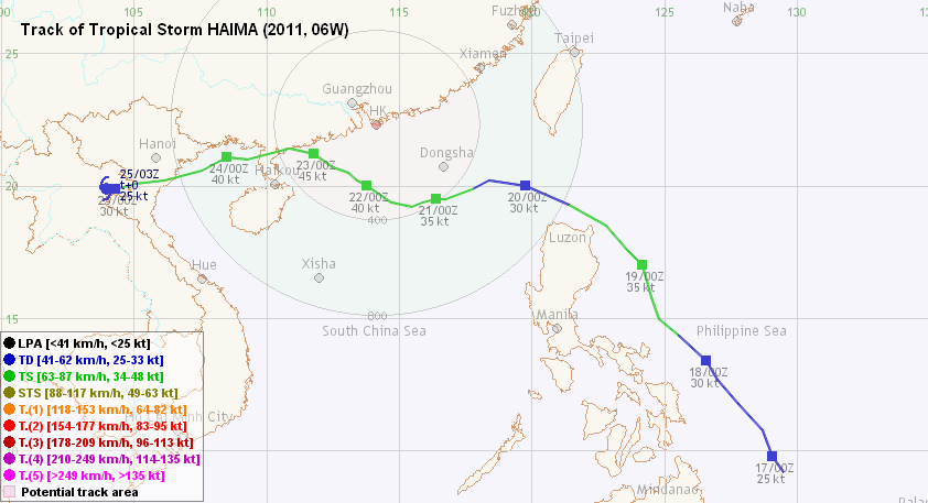
Figure 圖:
(Track courtesy of Lorenzo. Data from HKO. 鳴謝 Lorenzo 提供路徑圖,資料取自天文台)
IR imagery animation 紅外線雲圖動畫:
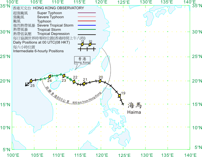
TC track from HKWW 本站的熱帶氣旋路徑圖:
TC track from HKO 天文台的熱帶氣旋路徑圖:
| Past HKWW Bulletins on HAIMA 本站有關海馬的發佈 |
Please click here for bulletins on HAIMA. 請按這裡。
| Storm Formation and Development 氣旋形成和發展 |
Unless otherwise stated, all times below are in Hong Kong Standard Time (UTC+8)
除非特別註明,下文時間均為香港標準時間 (協調世界時加 8 小時)
HAIMA necessitated the first Strong Wind Signal this year.
After the passage of SARIKA earlier in June, the intertropical convergence zone east of the Philippines became active again. An area of low pressure persisted in that region, which gradually intensified into tropical depression 06W on June 17. At that time most numerical forecasts predicted a consistent motion towards the NNW, hitting Taiwan in a few days' time. However, models from China predicted a gradual turn towards the west into the northern part of the South China Sea. As for strength prediction, almost all numerical models were not optimistic. In its initial forecast, the JTWC adopted the model concensus that 06W would travel towards Taiwan as a tropical depression or a minimal tropical storm.
06W remained as a tropical depression in the next 24 hours. Convections developed could not persist for long before dissipating, and tracking the centre using infrared satellite images was almost impossible. However, it could roughly be seen that the storm was moving NW to NNW in general, agreeing to the steering pattern that 06W was at the southwestern periphery of the subtropical ridge. 06W's inability to develop was believed to be linked to a tropical upper tropospheric trough to the north of the storm that was creating subsidence.
On June 18, visible satellite imagery showed that 06W's convections concentrated to the west of the low-level circulation centre, which was almost fully exposed. Forecast philosophy had also changed significantly - instead of predicting a consistent NW to NNW movement, the ridge was believed to extend westward, causing a WNW turn into the South China Sea through the Luzon Strait. The ridge would then retreat to allow 06W to resume its NW movement.
As 06W's structure improved (albeit slightly), the HKO upgraded it into a tropical depression at 21 HKT on June 18, after hinting at tropical cyclone formation in its weather bulletins for almost one and a half days. The HKO also shifted the predicted track westward on June 19, reaching areas within 200 km of Hong Kong in the next few days.
熱帶氣旋海馬令天文台發出本年首個三號強風信號。
莎莉嘉於六月較早前消散後,菲律賓以東的熱帶輻合帶再度變得活躍。一個低壓區逐漸發展,並於 6 月 17 日增強為熱帶低氣壓 06W。當時多數數值預報模式預測 06W 大致向西北偏北移動,趨向台灣,唯獨中國氣象台之模式預測 06W 於稍後轉向較西的方向移動並進入南海北部。至於強度預測方面,幾乎所有模式均對06W 的強度發展不樂觀。JTWC 的首佈跟隨多數模式預報之情況,即 06W 大致趨向台灣,強度為熱帶低氣壓至熱帶風暴下限。
06W 於未來 24 小時維持熱帶低氣壓強度。其中心附近雖有對流發展,但往往很快便消散,紅外線衛星雲圖更無法確認 06W 的中心,但大致上整個氣旋向西北至西北偏北移動,與駛流圖上 06W 處於副熱帶高壓脊西南面的格局相應。06W 未能發展,某程度上是因為風暴北面之一個熱帶對流層上部槽令該區輻散被抑制,不利 06W 增強。
6 月 18 日的可見光衛星雲圖顯示 06W 的對流集中在低層環流中心西面,環流中心則幾乎完全外露。預測方向亦明顯改變,由先前預計 06W 穩定移向台灣改為預測副高將稍為增強並令 06W 路徑偏西進入南海北部,其後才轉回向西北移動。
隨著 06W 的結構稍為轉好,天文台於 18 日晚 9 時將其升格為熱帶低氣壓,在此之前天文台已連續約一天半預計有熱帶氣旋形成。天文台於 19 日將其預測路徑西調,預測 06W 於未來數天將逐漸靠近,進入香港 200 公里範圍。
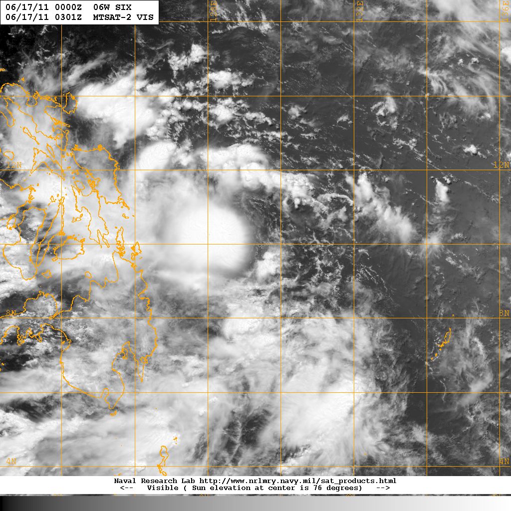
Figure 1 - Visible satellite imagery at 11 HKT, June 17
圖 1 - 6 月 17 日上午 11 時的可見光衛星雲圖

Figure 2 - Model forecast tracks at 08 HKT, June 16
圖 2 - 6 月 16 日上午 8 時之數值模式預測路徑圖

Figure 3 - Initial forecast track by JTWC
圖 3 - JTWC 之初始預報圖

Figure 4 - Steering flow chart at 14 HKT, June 19
圖 4 - 6 月 19 日下午 2 時之駛流圖


Figures 5a and 5b- HKO's forecast tracks at two different times
圖 5a 及 5b - 香港天文台於兩個不同時間之預測路徑圖
| Entering South China Sea 進入南中國海 |
Restricted divergence and moderate shear continued to inhibit 06W's intensification. By June 19, 06W had already moved to areas close to the northeastern tip of Luzon, but still without any signs of strengthening. Another possible reason for the slow intensification was that another disturbance developed just west of the Philippines, which was competiting with 06W the moisture from southwest monsoon that was needed to fuel the storm. As a result of the slight extension of the ridge and the interaction with this disturbance, 06W turned WNW and entered the South China Sea on June 20. At one time, the JTWC predicted a direct hit on Hong Kong as 06W's northward track component was expected to increase.
06W and the disturbance started to merge as they were in close proximity to each other. During the merger, 06W's centre was dragged slightly south, and multiple vortices appeared among the large patch of convections. Overall 06W moved WSW on June 20. Seeing 06W as a potential threat, the HKO issued the Standby Signal at 21:35 HKT on June 20, when 06W was 420 km SE of Hong Kong. The Observatory also mentioned that 06W was restructuring its convections, which could lead to changes in its future track.
Both shear and divergence conditions improved gradually. On June 21 06W started to decelerate. Its southward motion also stopped as the merger completed. Spiraling features became prominent in the afternoon. As a result, the JMA upgraded 06W into a tropical storm, naming it HAIMA. The name was contributed by China, meaning seahorse. All agencies predicted a WNW motion, possibly under the influence of a lower-level ridge in southern China. It was interesting to note that the HKO did not upgrade 06W into tropical storm status until the following day.
高風切和輻散被抑制令 06W 無法增強。6 月 19 日,06W 移至呂宋東北角對開海域,但仍未有任何增強跡象。06W 增強緩慢的另一個原因可能是由於呂宋西部的一個擾動正與 06W 爭奪由西南季候風帶來的水氣。隨著副高西伸及受該擾動影響,06W 於 20 日轉為向西北偏西移動。JTWC 曾經於其中一佈預料 06W 將於稍後回復較西北的路徑,並於香港登陸。
06W 靠近該擾動,兩者開始合併。合併期間 06W 主體被拉往南邊,在共同對流中出現多個漩渦。整體來說 06W 再 6 月 20 日向西南偏西移動。由於 06W 有機會對香港構成威脅,天文台在當晚 9 時 35 分發出一號戒備信號,當時 06W 集結於香港東南約 420 公里。天文台亦強調 06W 正在重組,對其路徑或會有影響。
此時風切和輻散環境逐步轉好。6 月 21 日,06W 開始減速。隨著合併完結,06W 停止向南移。下午 06W 的螺旋性增加,JMA 將其升格為熱帶風暴,並把其命名為海馬.。海馬一名由中國提供。所有預報機構均預測海馬向西北偏西移動,這可能是受到華南一低層高壓的影響。值得注意的是,天文台並沒有立即跟隨其他機構升格海馬為熱帶風暴,而只於隨後一日這樣做。

Figure 6 - Satellite imagery at 08 HKT, June 20. HAIMA was just off the northeastern tip of Luzon at that time
圖 6 - 6 月 20 日上午 8 時之衛星圖,當時海馬正於呂宋東北角對開海面

Figure 7 - Satellite imagery at 14 HKT, June 21. HAIMA was integrating with the disturbance to its south
圖 7 - 6 月 21 日下午 2 時之衛星圖,當時海馬正與其南面的擾動整合
| Intensification and Landfall 增強和登陸 |
From wind field charts, it could be clearly seen that HAIMA's strongest winds occurred at its periphery rather than its centre, a typical characteristic of monsoon depressions. For this reason, winds in Hong Kong strengthened steadily in the latter part of June 21 especially for areas exposed to the east, although HAIMA was still quite far away from the territory. For example, the 10-minute average wind speeds at Stanley and Waglan Island reached 40 and 60 km/h respectively near midnight, June 22.
HAIMA's convections diminished during the night, but the general centre could still be identified consistently on satellite imageries. It had also started to pick up a W/WNW track.
As winds in Hong Kong continued to strengthen, the HKO issued the Strong Wind Signal at 05:45 HKT on June 22. Strong winds were observed mainly near offshore waters and on high grounds, but by daytime Victoria Harbour stations had also started recording strong force easterlies. Hong Kong was also affected by occasional squally showers, but the intensity was mild.
HAIMA regained some convections in the next 12 hours, but they were mainly concentrated in the southern semicircle. The HKO upgraded HAIMA into a tropical storm at 10 HKT, and agencies gradually adjusted their intensities upward during the day. However, JTWC insisted that HAIMA was a tropical depression and the estimated intensity was just 25 knots (46 km/h), near the lower bound of a tropical cyclone.
HAIMA continued to edge closer to Hong Kong during the day. It was closest to Hong Kong in the night of June 22, when it was situated 240 km SSW of the territory. This roughly corresponds to the time when the strongest winds were recorded. Storm force winds were blowing at Ngong Ping, gale force winds were registered at places like Cheung Chau, Tate's Cairn and Waglan Island, and many more were blowing strong force winds.
After brief periods of stagnation, HAIMA picked up speed again in the small hours of June 23. Local winds also weakened steadily on the first half of the day. According to Chinese agencies, HAIMA made landfall near Dianbai and Yangxi at 10:10 HKT, at an intensity of a moderate tropical storm (around 20 m/s or 72 km/h in 2-minute average). However, most agencies predicted that HAIMA would move due west or even WSW, so that re-entry into waters was possible. In fact, the CMA reported that HAIMA made its second landfall at Wuchuan at 16:50 HKT.
As for tropical cyclone signals in Hong Kong, the Strong Wind Signal was replaced by the Standby Signal at 10:25 HKT, and all signals were removed at 20:45 HKT when HAIMA's influence further diminished.
由風場圖可見,海馬最大風的區域處於其週邊地區,反而中心附近風速較低,這是季風低壓的一個特徵。正因為如此,雖然海馬距離香港尚遠,本港風速亦於 6 月 21 日晚徐徐上升,尤其是東面沒有阻擋的地方。赤柱和橫瀾島的風速於 22 日凌晨分別達到每小時 40 和 60 公里。
海馬的對流於晚間再度減弱,但中心仍可於衛星圖上辨認到。海馬亦開始向西至西北偏西移動。
由於本港風勢穩步增強,天文台於 22 日上午 5 時 45 分發出三號強風信號。當時強風集中於離岸和高地出現,但數小時後強風區已擴展至維港一帶。本港亦受狂風驟雨影響,但總雨量未算高。
海馬的對流於之後 12 小時增加,但主要集中在南半圓。天文台於上午 10 時升格海馬為熱帶風暴,而大多數氣象台均於當天逐步調高海馬的強度。可是,JTWC 仍然認為海馬為熱帶低氣壓,估計強度更只得熱帶低氣壓下限之 25 節 (每小時 46 公里)。
海馬於日間繼續靠近香港。它於 22 日晚間最接近本港,當時集結在香港西南偏南約 240 公里。香港最強的風速亦大約於此時錄得 -- 昂平吹暴風;長洲、大老山和橫瀾島等地吹烈風,而更多市區地方則吹強風。
一輪停滯過後,海馬於 23 日凌晨加速移動,本港風勢亦於當天早上逐步緩和。根據中國天氣網,海馬於上午 10 時 10 分於電白和陽西交界處登陸,兩分鐘最高持續風速約為每秒 20 米 (每小時 72 公里)。雖然海馬已登陸,大多數機構預料海馬將向西甚至西南偏西移動,因此可能再度進入洋面。事實上,中國天氣網稱海馬在當天下午 4 時 50 分在吳川一帶再度登陸。
至於香港熱帶氣旋信號方面,天文台於上午 10 時 25 分發出一號戒備信號,而其後在晚上 8 時 45 分取消該信號。

Figure 8 - Wind field chart at around 09:30 HKT, June 22
圖 8 - 6 月 22 日約上午 9 時半之風場圖


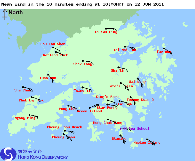

Figures 9a to 9d - Wind distribution in Hong Kong at 6-hour intervals
圖 9a 至 9d - 每 6 小時的平均風速風向分佈圖


Figures 10a and 10b- Mean wind speed at Cheung Chau on June 22 and June 23
圖 10a 及 10b - 長洲於 6 月 22 及 23 日所錄得的平均風速

Figure 11 - HAIMA near its closest approach to Hong Kong
圖 11 - 海馬於最接近香港處
| Returning to Sea and Final Landfall 重返海上及最後一次登陸 |
Possibly because of the low-level ridge, HAIMA moved due west on June 23, with some slight southward track component in the latter part of the day. After crossing the northern Leizhou Peninsula, it entered the Gulf of Tonkin near 20 HKT. HAIMA's structure improved as it regained energy, and some agencies raised its estimated strength. Both KMA and CMA regarded HAIMA as a strong tropical storm at 14 HKT on June 24, while HKO, JMA and CWB put it as a moderate one. The JTWC raised HAIMA's strength slightly, into a minimal tropical storm.
HAIMA made its final landfall in northern Vietnam at around 20 HKT on June 24. It continued to move west into northern Laos and dissipated on June 25.
可能受低層高壓影響,海馬於 6 月 23 日向西移動,後段時間更出現向南分量。經過雷州半島北部後,海馬於下午約 8 時進入北部灣。海馬重新獲得能量,結構亦因而鞏固起來,部分氣象台對其強度有所提升。至 24 日下午 2 時,中國中央氣象台 (CMA) 和韓國氣象廳 (KMA) 均估計海馬為較強之熱帶風暴,而香港天文台、日本氣象廳 (JMA) 和台灣中央氣象局 (CWB) 亦估計海馬達中等熱帶風暴強度。至於 JTWC 則略為提高海馬之強度為熱帶風暴下限。
海馬在當晚 8 時登陸越南北部。它其後繼續西移,進入老撾北部,並在 25 日消散。

Figure 12 - HAIMA about to make landfall in northern Vietnam
圖 12 - 海馬將於越南北部登陸
| Local Aircraft Reconnaissance 本地飛機偵察 |
As HKO later revealed in a press release, the Observatory collaborated with the Hong Kong Government Flying Service to collect meteorological data during the passage of HAIMA on June 22. This could be a possible reason for HKO not to upgrade HAIMA into a tropical storm until June 22, which was significantly later than other agencies including the CMA, JMA, CWB and KMA. For more details on the mission, please visit HKO Side Lights.
天文台其後表示曾在 6 月 22 日,即海馬在南海橫過時與政府飛行服務隊合作,派出飛機深入風暴中心以收集氣象數據。這可能是天文台比各大氣象台較遲升格海馬為熱帶風暴之原因。有關此任務之資訊,請參閱天文台動態。
| Winds Recorded at Reference Stations 參考站所錄得的風速 |
| Station 風速站 |
Max. 10-min avg. wind speed 最高十分鐘平均風速 |
Beaufort classification 蒲福氏風級分類 |
| Chek Lap Kok 赤鱲角 | 60 km/h | STRONG 強風 |
| Cheung Chau 長洲 | 84 km/h | GALE 烈風 |
| Kai Tak 啟德 | 49 km/h | STRONG 強風 |
| Sai Kung 西貢 | 52 km/h | STRONG 強風 |
| Sha Tin 沙田 | 30 km/h | Moderate 和緩 |
| Ta Kwu Ling 打鼓嶺 | 31 km/h | Fresh 清勁 |
| Tsing Yi (SHL) 青衣蜆殼油庫 | 32 km/h | Fresh 清勁 |
| Wetland Park 濕地公園 | 26 km/h | Moderate 和緩 |
| Number of stations recording at least STRONG force (force 6 - 7) winds: | 4 |
| Number of stations recording at least GALE force (force 8 - 9) winds: | 1 |
| Number of stations recording at least STORM force (force 10 - 11) winds: | 0 |
| Number of stations recording HURRICANE force (force 12) winds: | 0 |
| 錄得 強風 (6 - 7 級) 或更高風速的站數: | 4 |
| 錄得 烈風 (8 - 9 級) 或更高風速的站數: | 1 |
| 錄得 暴風 (10 - 11 級) 或更高風速的站數: | 0 |
| 錄得 颶風 (12 級) 風速的站數: | 0 |
| Charts and Figures 各項數據 |
Table 1: Track data from HKWW:
表一 : 香港天氣觀測站之路徑資料
YYMMDDZZ Lat Long Wind |
Table 2: Maximum gust and hourly average wind speed recorded in Hong Kong from HKO:
表二 : 香港天文台公佈的各站最高每小時平均風力和陣風數據
| Station | Maximum Gust |
Maximum Hourly Mean Wind |
||||||
| Station | Direction |
Speed (km/h) |
Date/Month |
Time |
Direction |
Speed (km/h) |
Date/Month |
Time |
| Bluff Head (Stanley) | SE |
92 |
22/6 |
22:58 |
SE |
56 |
22/6 |
22:00 |
| Central Pier | E |
70 |
22/6 |
21:29 |
E |
41 |
22/6 |
19:00 |
| Cheung Chau | SE |
104 |
22/6 |
22:02 |
SE |
77 |
22/6 |
23:00 |
SE |
77 |
23/6 |
00:00 |
|||||
| Cheung Chau Beach | E |
99 |
22/6 |
23:16 |
E |
68 |
23/6 |
00:00 |
| Green Island | - |
90 |
22/6 |
21:47 |
- |
49 |
23/6 |
03:00 |
| Hong Kong International Airport | ESE |
87 |
22/6 |
22:37 |
ESE |
52 |
22/6 |
23:00 |
ESE |
52 |
23/6 |
01:00 |
|||||
| Kai Tak | ESE |
77 |
22/6 |
23:19 |
E |
43 |
22/6 |
23:00 |
| King's Park | ESE |
68 |
22/6 |
22:12 |
ESE |
31 |
23/6 |
02:00 |
| Lau Fau Shan | E |
63 |
22/6 |
10:49 |
E |
31 |
22/6 |
11:00 |
| Ngong Ping | E |
146 |
23/6 |
08:38 |
E |
103 |
23/6 |
00:00 |
| North Point | E |
77 |
22/6 |
12:52 |
E |
40 |
22/6 |
14:00 |
| Peng Chau | E |
75 |
22/6 |
10:33 |
E |
45 |
22/6 |
15:00 |
| Ping Chau | E |
58 |
22/6 |
14:47 |
E |
16 |
22/6 |
16:00 |
| Sai Kung | SE |
75 |
22/6 |
22:30 |
SE |
43 |
22/6 |
23:00 |
| Sha Chau | ESE |
81 |
23/6 |
01:36 |
SE |
56 |
23/6 |
00:00 |
SSE |
81 |
23/6 |
10:28 |
|||||
| Sha Lo Wan | ESE |
99 |
23/6 |
08:32 |
ESE |
41 |
23/6 |
09:00 |
| Sha Tin | ENE |
56 |
22/6 |
17:57 |
SE |
25 |
23/6 |
05:00 |
ESE |
56 |
22/6 |
19:34 |
|||||
| Shek Kong | E |
70 |
23/6 |
10:12 |
E |
31 |
22/6 |
17:00 |
| Star Ferry (Kowloon) | ESE |
83 |
22/6 |
22:32 |
E |
47 |
22/6 |
23:00 |
| Ta Kwu Ling | ENE |
68 |
22/6 |
23:40 |
E |
27 |
22/6 |
21:00 |
| Tai Mei Tuk | ENE |
101 |
22/6 |
11:26 |
E |
58 |
22/6 |
17:00 |
| Tai Mo Shan | SE |
121 |
23/6 |
01:58 |
SE |
83 |
23/6 |
08:00 |
| Tap Mun | ESE |
72 |
22/6 |
21:50 |
SE |
45 |
23/6 |
08:00 |
| Tate's Cairn | E |
113 |
22/6 |
15:45 |
E |
67 |
22/6 |
11:00 |
| Tsak Yue Wu | E |
47 |
22/6 |
20:29 |
E |
13 |
23/6 |
01:00 |
E |
13 |
23/6 |
02:00 |
|||||
| Tseung Kwan O | SSE |
62 |
22/6 |
15:43 |
SE |
20 |
23/6 |
07:00 |
| Tsing Yi Shell Oil Depot | ESE |
76 |
22/6 |
22:27 |
ESE |
27 |
23/6 |
01:00 |
| Tuen Mun Government Offices | SE |
75 |
22/6 |
23:14 |
SE |
30 |
23/6 |
08:00 |
| Waglan Island | SE |
90 |
22/6 |
23:00 |
SE |
67 |
22/6 |
23:00 |
| Wetland Park | SE |
51 |
22/6 |
23:28 |
E |
22 |
22/6 |
17:00 |
| Wong Chuk Hang | ESE |
79 |
23/6 |
00:59 |
E |
31 |
23/6 |
03:00 |
Table 3: Rainfall (in millimetres) contributed by HAIMA from HKO (figures in brackets are based on incomplete hourly data):
表三 : 香港天文台公佈的各站雨量資料 (方括號內之數據由不完整之每小時資料擷取)
| Station | 20-Jun |
21-Jun |
22-Jun |
23-Jun |
Total (mm) |
|
| Hong Kong Observatory | 0.0 |
8.3 |
41.4 |
Trace |
49.7 |
|
| Cheung Chau (CCH) | [0.5] |
[3.5] |
[15.0] |
[0.0] |
[19.0] |
|
| Hong Kong International Airport (HKA) | 0.0 |
3.0 |
38.8 |
48.4 |
90.2 |
|
| N05 | Fanling | 0.0 |
0.5 |
52.0 |
7.0 |
59.5 |
| N13 | High Island | 0.0 |
8.5 |
45.5 |
0.0 |
54.0 |
| K04 | Jordan Valley | 0.0 |
9.5 |
48.5 |
0.0 |
58.0 |
| N06 | Kwai Chung | 0.0 |
3.5 |
73.5 |
0.0 |
77.0 |
| H12 | Mid Levels | 0.0 |
12.0 |
81.5 |
0.0 |
93.5 |
| H21 | Repulse Bay | 1.0 |
15.0 |
64.5 |
0.0 |
80.5 |
| N09 | Sha Tin | 0.0 |
6.5 |
65.0 |
0.0 |
71.5 |
| H19 | Shau Kei Wan | 0.0 |
15.5 |
39.5 |
0.0 |
55.0 |
| SEK | Shek Kong | 0.0 |
2.5 |
76.0 |
2.5 |
81.0 |
| K06 | So Uk Estate | 0.0 |
1.5 |
52.0 |
0.0 |
53.5 |
| R31 | Tai Mei Tuk | 0.0 |
4.5 |
44.5 |
0.5 |
49.5 |
| R21 | Tap Shek Kok | 0.0 |
0.5 |
51.5 |
11.0 |
63.0 |
| N17 | Tung Chung | 0.0 |
2.0 |
51.5 |
[54.5] |
[108.0] |
| R27 | Yuen Long | 1.5 |
4.0 |
51.0 |
1.0 |
57.5 |
Last Accessed 最近訪問日期: Fri Apr 19 2024 13:40:27 HKT
Last Modified 最近修訂日期: Mon Jul 24 2023
