
TC Watch / 熱帶氣旋 > Selected TC Review / 重要熱帶氣旋回顧 > 201110W (NOCK-TEN 洛坦) [Refresh 更新]
 201110W (NOCK-TEN 洛坦) - Profile 檔案 201110W (NOCK-TEN 洛坦) - Profile 檔案 |
(First draft issued on August 12, 2011; final version issued on August 15, 2011)
(初稿於 2011 年 8 月 12 日發出,最後版本於 8 月 15 日上載)
Additional Information 附加資料 : Wind Speed Data for TCs that Have Affected Hong Kong 影響香港氣旋之風速數據
Brief profile of NOCK-TEN 洛坦小檔案:
| JTWC number 聯合颱風警報中心 (JTWC) 號碼 | 10W |
| International number 國際編號 | 1108 |
| Period of existence 生存時期 (JTWC) | 2011/07/25 02 HKT - 2011/07/30 20 HKT |
| Lifetime 壽命 (JTWC) | 5.75 days 日 |
| Maximum 1-minute wind (JTWC) JTWC 一分鐘平均最高中心風速 | 65 knots 節 (Category 1 Typhoon 一級颱風) |
| Minimum pressure (JTWC) JTWC 最低氣壓 | 974 hPa 百帕 |
| Highest TC signal by HKO (if applicable) 香港天文台發出最高熱帶氣旋警告信號 |
3 (Strong Wind Signal 強風信號) |
| Closest point of approach by HKO (if applicable) 香港天文台所示之最接近距離 (如適用) |
SSW 450 km (real-time warning 實時報告) / SW 440 km (TC Report 熱帶氣旋報告) |
| Time of closest approach by HKO (if applicable) 香港天文台所示之最接近時間 (如適用) |
2011/07/29 15 HKT (real-time warning 實時報告) / 14 HKT (TC Report 熱帶氣旋報告) |
| Lowest pressure recorded at HKO (if applicable) 香港天文台錄得的最低氣壓 (如適用) |
1000.8 hPa 百帕 (2011/07/29 06:26 HKT) |
TC signals for Hong Kong & Track 香港曾經生效的熱帶氣旋警告和路徑圖:
Table 表:
| Signal 信號 |
Date and time 日期和時間 |
Distance from HK 與香港的距離 |
Predicted movement 預測移動方向和速度 |
Max. 10-min winds 中心最高十分鐘平均風速 |
 |
2011/07/28 (THU) 08:40 HKT |
SSE 560 km |
WNW at 20 km/h |
90 km/h (50 knots, STS) |
 |
2011/07/28 (THU) 18:45 HKT |
S 460 km |
WNW at 20 km/h |
90 km/h (50 knots, STS) |
|
2011/07/29 (FRI) 14:10 HKT |
SSW 460 km |
WNW at 18 km/h |
90 km/h (50 knots, STS) |
 |
2011/07/29 (FRI) 16:40 HKT |
SW 450 km |
WNW at 18 km/h |
90 km/h (50 knots, STS) |
Figure 圖:
(Track courtesy of Lorenzo. Data from HKO. 鳴謝 Lorenzo 提供路徑圖,資料取自天文台)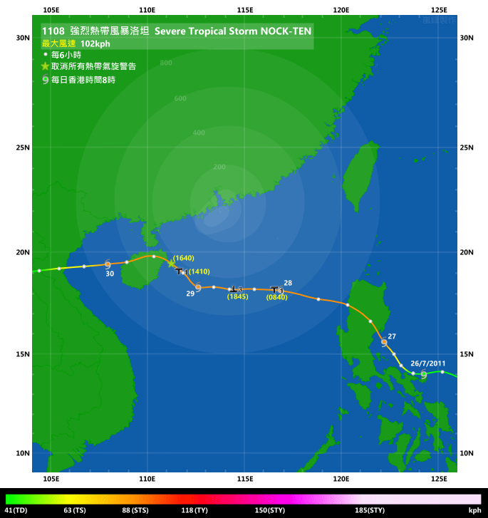
IR imagery animation 紅外線雲圖動畫:
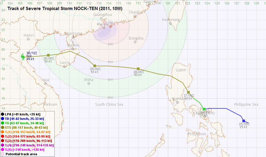
TC track from HKWW 本站的熱帶氣旋路徑圖:
TC track from HKO 天文台的熱帶氣旋路徑圖:

| Past HKWW Bulletins on NOCK-TEN 本站有關洛坦的發佈 |
Please click here for bulletins on NOCK-TEN. 請按這裡。
| Storm Formation and Development 氣旋形成和發展 |
Unless otherwise stated, all times below are in Hong Kong Standard Time (UTC+8)
除非特別註明,下文時間均為香港標準時間 (協調世界時加 8 小時)
Prior to the formation of NOCK-TEN, numerical models had been persistently predicting tropical cyclone formation east of the Philippines, which would then move into the South China Sea or (for some models) make landfall at Taiwan. In one ECMWF numerical forecast prediction a typhoon would make a direct hit on Hong Kong on July 29. It turned out that most of these projections put the storm much further north of its actual track.
The disturbance that would develop into NOCK-TEN intensified into tropical depression on July 24, and the JTWC designated the storm number 10W for it. In its initial track forecast, 10W would travel NW towards the northeastern tip of Luzon, and then resume WNW movement towards central Guangdong coast. This tropical depression remained rather disorganized on July 25, but convections tightened on the next day. The JMA upgraded 10W into a tropical storm at 08 HKT on July 26, naming it NOCK-TEN. This name was provided by Laos, meaning bird.
NOCK-TEN travelled west steadily instead of NW according to initial projections. Those projections were subsequently adjusted towards the west, and by afternoon all agencies were predicting that NOCK-TEN would make landfall at northern Hainan or Leizhou Peninsula. This is a result of the rather strong and zonal ridge that was expected to keep NOCK-TEN travelling west or WNW.
早於洛坦形成以前,不同數值預報模式均預測菲律賓以東海域將有一熱帶氣旋形成,隨後進入南海或登陸台灣。歐洲中期天氣預報更曾有一報預測一股達颱風強度的氣旋於 7 月 29 日直趨香港。可是,事實上大部分預測比實際路徑偏北。
該熱帶擾動於 7 月 24 日增強為熱帶低氣壓,JTWC 給予風暴編號 10W。最初預計路徑顯示 10W 向西北移動,掠過呂宋東北角,繼而向西北偏西移動並趨向廣東中部沿岸。此熱帶低氣壓於 25 日仍然卻乏組織,但對流於翌日收緊。日本氣象廳 (JMA) 於 26 日上午 8 時升格 10W 為熱帶風暴,並將其命名為洛坦。此名稱由老撾提供,意思為鳥。
洛坦並沒有像預測般向西北移動,而是一直西移,這使預測路徑西調,到下午各氣象台已開始預計洛坦將登陸海南北部或雷州半島。洛坦路徑偏西,很大程度上是由於副熱帶高壓脊強盛且呈帶狀,令洛坦沒有北上的空間。
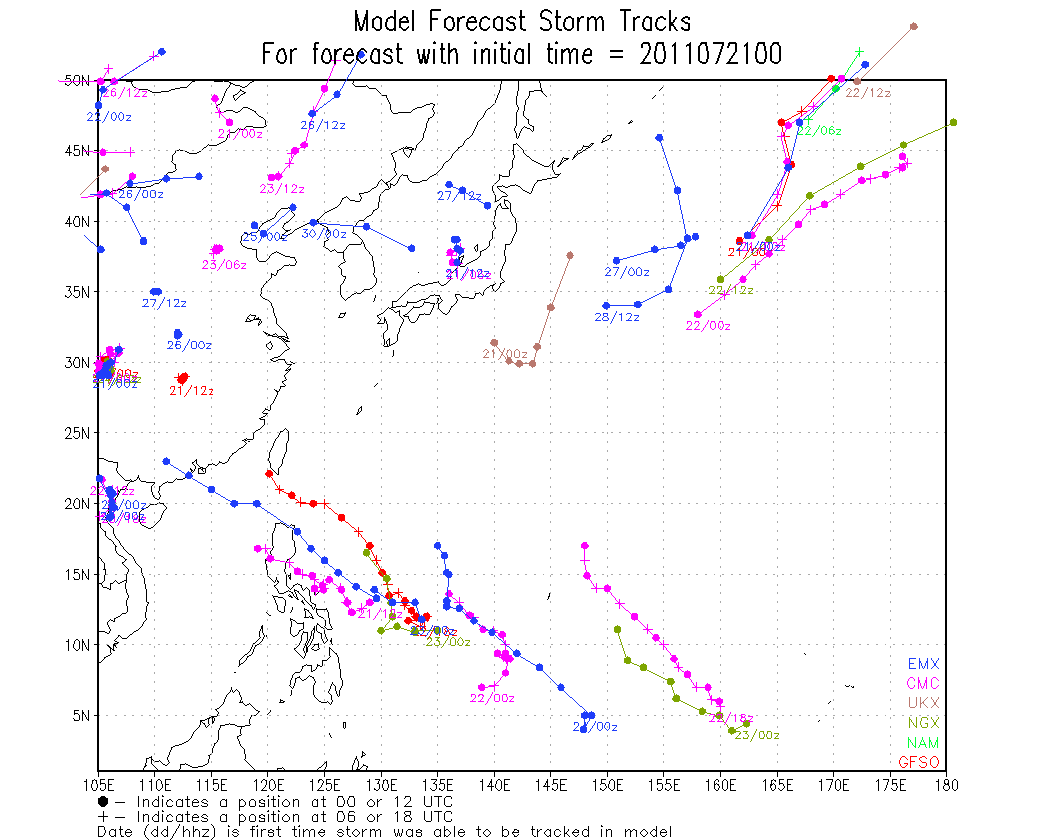
Figure 1 - Model forecast tracks at 08 HKT, July 21
圖 1 - 7 月 21 日上午 8 時之數值模式預測路徑圖


Figures 2a and 2b - Satellite images on July 24 and 26
圖 2a 及 2b - 7 月 24 及 26 日之衛星雲圖

Figure 3 - Steering flow chart at 14 HKT, July 26
圖 3 - 7 月 26 日下午 2 時之駛流圖

Figure 4 - Forecast tracks from different official agencies
圖 4 - 各官方氣象台之預測路徑
| First Landfall and Entering South China Sea 首次登陸及進入南中國海 |
Convections north of NOCK-TEN expanded on July 26, and spiraling bands became prominent by sunset. The storm had also turned NW but a landfall at Luzon seemed inevitable. Agencies upgraded NOCK-TEN into a severe tropical storm in the morning of July 27. The JTWC even upgraded it into a typhoon at 08 HKT as a banding eye seemed to be developing. The JTWC became the only agency that designated NOCK-TEN as a typhoon though, as the storm made landfall at Luzon just a few hours later. Predictably, the formative eye disappeared soon after landfall, but overall convective features were maintained. NOCK-TEN remained as a severe tropical storm in the whole process of crossing Luzon.
The storm travelled NW persistently as it crossed the mountainous territory. It entered the South China Sea at around 20 HKT, exiting the Philippines near San Fernando.
NOCK-TEN's lower level structure was somewhat destroyed by the terrains of Luzon. The destruction caused gradually became apparent in the next 12 hours. Due to the lack of visible satellite imagery, the low-level circulation centre could not be reliably determined. By daybreak, it started to become obvious that the centre had drifted westward at high speed --- from 20 HKT of July 27 to 08 HKT of July 28, the centre drifted around 370 km westward, or at a rate of more than 30 km/h. It was also evident that NOCK-TEN had reverted to its westerly motion.
洛坦的對流於 7 月 26 日擴展,日落前後螺旋性漸見明顯。它亦開始採取較西北的路徑,登陸呂宋已無可避免。各站於 27 日上午升格洛坦為強烈熱帶風暴,而由於一雲捲風眼正在發展,JTWC 更於上午 8 時將洛坦升格為颱風。但由於洛坦數小時後在呂宋登陸,JTWC 成為唯一一個將洛坦定為颱風的機構。初形成的風眼於登陸後不久消失,但整體對流特徵維持。洛坦於橫過呂宋期間維持強烈熱帶風暴強度。
洛坦穩定地向西北橫過呂宋,並於約晚上 8 時離開聖費南多市,進入南海。
洛坦的低層環流被呂宋高山破壞,破壞程度於其後 12 小時逐漸變得明顯。由於晚間缺乏可見光衛星影像,洛坦的低層環流中心未能被準確找到。到破曉時份,從雲圖上可見洛坦的中心於整晚以高速西移,由 27 日下午 8 時至 28 日上午 8 時共西移了約 370 公里,即時速高逾 30 公里。此亦證明洛坦已回復其西移軌跡。
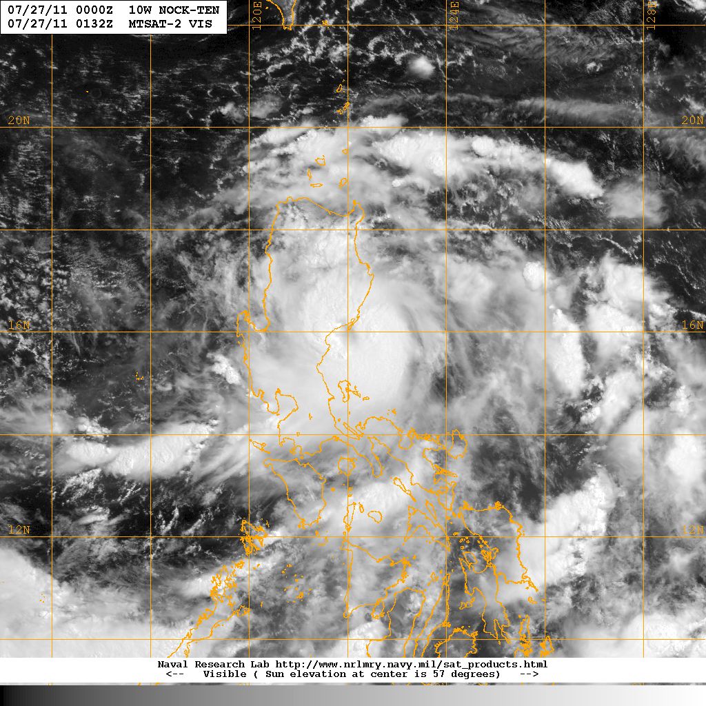
Figure 5 - NOCK-TEN making landfall at Luzon
圖 5 - 洛坦於呂宋登陸
| Traversing South China Sea and Second Landfall at Hainan Island 橫過南海並登陸海南 |
Affected by NOCK-TEN, local wind direction changed to north or northeast in the morning of July 28. NOCK-TEN's fast pace also meant that it got closer earlier than expected. The Hong Kong Observatory issued the #1 Standby Signal at 08:40 HKT. In fact, the storm was already 560 km SSE of Hong Kong when the signal was issued.
Easterly winds prevailed in the afternoon of July 28. Winds picked up gradually, and NOCK-TEN was slowly reorganizing its structure. Showers briefly affected the New Territories in the afternoon as well, but the weather was in general fine as Hong Kong was still too far away from the storm to be affected by its major rain bands. As the day progressed, winds reached strong force level at certain offshore locations like Cheung Chau and Waglan Island. Foreseeing a continual increase in wind speed, the Observatory issued the #3 Strong Wind Signal at 18:45 HKT, when NOCK-TEN was located 460 km south of Hong Kong. Signs of strengthening were also observed, and the Observatory raised its estimated strength from 90 km/h to 105 km/h at 20 HKT.
Strongest winds were generally observed in the small hours of July 29. However, NOCK-TEN did not move away significantly in the morning as it jogged NW briefly around noon that day. Nevertheless, possibly as a result of tightening wind radius, local winds eased off in the afternoon. Occasional squally showers were observed, but the total rainfall amount was generally mild. The Observatory replaced the Strong Wind Signal by the Standby Signal at 14:10 HKT and further cancelled all signals at 16:40 HKT. It is worth noting that NOCK-TEN was about 450 km SW of Hong Kong at 16 HKT, not far away from its closest point of approach (also around 450 km).
NOCK-TEN turned WNW as it approached Hainan Island. According to Chinese authorities, the storm made landfall at Wenchang (文昌) at 17:40 HKT, with maximum wind speed of around 28 m/s (101 km/h, 54 knots) and pressure 980 hPa.
受洛坦影響,本港風向於 28 日早上轉為北至東北。由於洛坦移動較預期快,它與香港的距離亦快速收窄。香港天文台於上午 8 時 40 分發出一號戒備信號,當時洛坦集結在香港東南偏南約 560 公里。
28 日下午,本港轉吹東風。風勢逐漸加強,而洛坦亦開始重整結構。驟雨短暫影響新界,但由於洛坦距離香港尚遠,本港下午天色仍然明朗。隨著時間過去,本港部分離岸地區如長洲和橫瀾島開始吹強風。由於預計風勢將增強,天文台於下午 6 時 45 分改發三號強風信號,當時洛坦於香港以南約 460 公里。天文台亦於晚上 8 時稍為調高洛坦的強度,由每小時 90 公里上調至 105 公里。
香港的風勢於 29 日凌晨到達最高點,但洛坦並未明顯移離,而是在當天中午多次北跳。雖然如此,可能由於洛坦風圈縮小,風力於下午開始減弱。雖然本港多處有幾陣狂風驟雨,但總雨量並不高。天文台於下午 2 時 10 分改發一號戒備信號,並於下午 4 時 40 分取消該信號。值得注意的是取消信號當時洛坦處於香港西南約 450 公里,約為最接近香港的距離 (同樣是 450 公里)。
洛坦於登陸海南島前轉回向西北偏西移動。根據中國官方報導,洛坦於 29 日下午 5 時 40 分在海南文昌一帶登陸,最高風速為每秒 28 米 (每小時 101 公里或 54 海里),海平面氣壓 980 百帕斯卡。

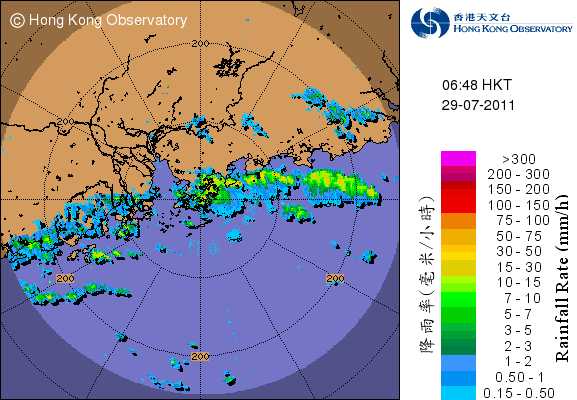

Figures 6a to 6c - Three different rain bands associated with NOCK-TEN that struck Hong Kong
圖 6a 至 6c - 與洛坦相關連的三條雨帶影響香港


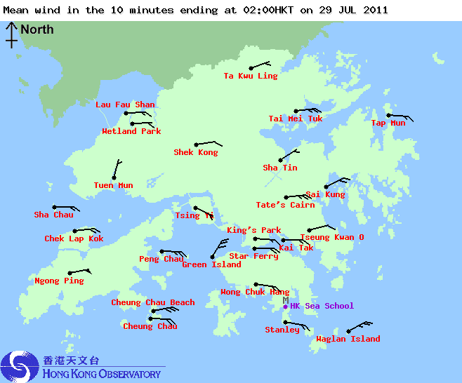

Figures 7a to 7d - Local wind distribution at 6-hour intervals
圖 7a 至 7d - 每 6 小時一幅之本地風勢分佈圖


Figures 8a and 8b- Mean wind speed at Cheung Chau on July 28 and 29
圖 8a 及 8b - 長洲於 7 月 28 及 29 日所錄得的平均風速

Figure 9 - NOCK-TEN at closest approach to Hong Kong
圖 9 - 洛坦於最接近香港時之位置

Figurs 10 - NOCK-TEN jogged NW prior to landfall at Hainan
圖 10 - 洛坦於海南登陸前向西北移動
| Final Landfall and Dissipation 最後一次登陸與消散 |
Northern Hainan is relatively flat, which means NOCK-TEN could traverse with ease and without losing much intensity. The storm deflected to the WSW as it reached Haikou (海口). It spent only a few hours on Hainan and entered the Gulf of Tonkin at around 02 HKT on July 30. Still, due to proximity to land, NOCK-TEN lost some intensity as it travelled inside the Gulf.
NOCK-TEN finally made landfall in northern Vietnam at around 20 HKT that night as a tropical storm. It quickly weakened and eventually dissipated early on July 31 in Laos, the origin of the storm's name.
由於海南北部相對較平坦,洛坦輕鬆通過,強度未有大幅下降。它於到達海口市前後向西南方偏折。數小時後洛坦離開海南,於 7 月 30 日約上午 2 時進入北部灣。由於離陸地不遠,洛坦再橫過北部灣時稍為減弱。
洛坦於 30 日晚約 8 時以熱帶風暴強度登陸越南北部。它快速減弱,最終於 31 日早上在其名稱發源地 --- 老撾消散。

Figure 11 - NOCK-TEN crossing the Gulf of Tonkin
圖 11 - 洛坦正橫過北部灣
| Winds Recorded at Reference Stations 參考站所錄得的風速 |
| Station 風速站 |
Max. 10-min avg. wind speed 最高十分鐘平均風速 |
Beaufort classification 蒲福氏風級分類 |
| Chek Lap Kok 赤鱲角 | 53 km/h | STRONG 強風 |
| Cheung Chau 長洲 | 61 km/h | STRONG 強風 |
| Kai Tak 啟德 | 40 km/h | Fresh 清勁 |
| Sai Kung 西貢 | 43 km/h | STRONG 強風 |
| Sha Tin 沙田 | 25 km/h | Moderate 和緩 |
| Ta Kwu Ling 打鼓嶺 | 25 km/h | Moderate 和緩 |
| Tsing Yi (SHL) 青衣蜆殼油庫 | 32 km/h | Fresh 清勁 |
| Wetland Park 濕地公園 | 32 km/h | Fresh 清勁 |
| Number of stations recording at least STRONG force (force 6 - 7) winds: | 3 |
| Number of stations recording at least GALE force (force 8 - 9) winds: | 0 |
| Number of stations recording at least STORM force (force 10 - 11) winds: | 0 |
| Number of stations recording HURRICANE force (force 12) winds: | 0 |
| 錄得 強風 (6 - 7 級) 或更高風速的站數: | 3 |
| 錄得 烈風 (8 - 9 級) 或更高風速的站數: | 0 |
| 錄得 暴風 (10 - 11 級) 或更高風速的站數: | 0 |
| 錄得 颶風 (12 級) 風速的站數: | 0 |
| Charts and Figures 各項數據 |
Table 1: Track data from HKWW:
表一 : 香港天氣觀測站之路徑資料
YYMMDDZZ Lat Long Wind |
Table 2: Maximum gust and hourly average wind speed recorded in Hong Kong from HKO:
表二 : 香港天文台公佈的各站最高每小時平均風力和陣風數據
Station |
Maximum Gust |
Maximum Hourly Mean Wind |
||||||
| Station | Direction |
Speed (km/h) |
Date/Month |
Time |
Direction |
Speed (km/h) |
Date/Month |
Time |
| Bluff Head (Stanley) | SE |
72 |
29/7 |
06:39 |
E |
38 |
29/7 |
05:00 |
| Central Pier | ENE
|
67
|
28/7
|
19:33
|
E |
45 |
29/7 |
02:00 |
E |
45 |
29/7 |
04:00 |
|||||
| Cheung Chau | SSE |
92 |
29/7 |
14:05 |
E |
52 |
29/7 |
06:00 |
| Cheung Chau Beach | ENE |
83 |
28/7 |
21:22 |
E
|
58
|
29/7
|
00:00
|
E |
83 |
28/7 |
23:02 |
|||||
E |
83 |
29/7 |
01:25 |
|||||
| Green Island | NE |
94 |
29/7 |
06:47 |
NNE |
56 |
29/7 |
02:00 |
| Hong Kong International Airport | NE |
85 |
28/7 |
17:13 |
E |
41 |
29/7 |
05:00 |
| Kai Tak | E |
79 |
29/7 |
00:29 |
E |
31 |
29/7 |
03:00 |
| King's Park | E |
65 |
29/7 |
00:11 |
ESE |
25 |
29/7 |
13:00 |
| Lau Fau Shan | SSE |
72 |
29/7 |
15:02 |
E |
31 |
29/7 |
01:00 |
| Ngong Ping | ENE |
122 |
29/7 |
00:31 |
E |
96 |
29/7 |
00:00 |
| North Point | E |
68 |
29/7 |
02:52 |
E |
38 |
29/7 |
01:00 |
| Peng Chau | E |
75 |
28/7 |
22:02 |
E |
45 |
29/7 |
01:00 |
| Ping Chau | E |
54 |
28/7 |
23:38 |
E
|
14
|
29/7
|
00:00
|
E |
54 |
29/7 |
02:55 |
|||||
| Sai Kung | ENE |
63 |
28/7 |
23:53 |
E |
38 |
29/7 |
06:00 |
| Sha Chau | NNE |
85 |
28/7 |
17:12 |
ESE |
34 |
29/7 |
15:00 |
| Sha Lo Wan | E |
68 |
28/7 |
23:11 |
E |
40 |
29/7 |
00:00 |
| Sha Tin | NNW |
52 |
29/7 |
05:20 |
NE |
20 |
29/7 |
00:00 |
| Shek Kong | NNE |
59 |
29/7 |
02:19 |
E |
23 |
29/7 |
08:00 |
| Star Ferry (Kowloon) | E |
75 |
29/7 |
06:42 |
E |
41 |
29/7 |
03:00 |
| Ta Kwu Ling | NE
|
51
|
29/7
|
04:25
|
E |
19 |
29/7 |
00:00 |
ENE |
19 |
29/7 |
02:00 |
|||||
| Tai Mei Tuk | E |
79 |
29/7 |
06:40 |
E |
51 |
29/7 |
07:00 |
| Tai Mo Shan | - |
96 |
29/7 |
06:03 |
- |
58 |
29/7 |
05:00 |
| Tap Mun | SE |
59 |
29/7 |
06:36 |
E |
31 |
29/7 |
00:00 |
| Tate's Cairn | ESE |
96 |
29/7 |
06:41 |
E |
58 |
29/7 |
04:00 |
| Tsak Yue Wu | NE |
43 |
29/7 |
12:20 |
E |
14 |
28/7 |
16:00 |
| Tseung Kwan O | E |
52 |
29/7 |
05:28 |
E |
16 |
29/7 |
02:00 |
| Tsing Yi Shell Oil Depot | SE
|
59
|
29/7
|
14:46
|
ESE |
22 |
28/7 |
23:00 |
ESE |
22 |
29/7 |
00:00 |
|||||
| Tuen Mun Government Offices | ESE |
54 |
29/7 |
14:58 |
SE |
22 |
29/7 |
15:00 |
| Waglan Island | E |
92 |
29/7 |
06:32 |
E |
52 |
29/7 |
05:00 |
| Wetland Park | NNE
|
70
|
28/7
|
16:44
|
E |
22 |
29/7 |
05:00 |
E |
22 |
29/7 |
06:00 |
|||||
| Wong Chuk Hang | E |
70 |
29/7 |
00:27 |
E |
31 |
29/7 |
01:00 |
Table 3: Rainfall (in millimetres) contributed by NOCK-TEN from HKO (figures in brackets are based on incomplete hourly data):
表三 : 香港天文台公佈的各站雨量資料 (方括號內之數據由不完整之每小時資料擷取)
| Station | 28-Jul |
29-Jul |
Total (mm) |
|
| Hong Kong Observatory | Trace |
12.4 |
12.4 |
|
| Hong Kong International Airport (HKA) | 0.2 |
27.9 |
28.1 |
|
| N26 | Cheung Chau | 0.0 |
22.5 |
22.5 |
| N05 | Fanling | 3.5 |
50.5 |
54.0 |
| N13 | High Island | 0.0 |
[7.0] |
[7.0] |
| K04 | Jordan Valley | 0.0 |
23.0 |
23.0 |
| N06 | Kwai Chung | 0.0 |
8.5 |
8.5 |
| H12 | Mid Levels | 0.0 |
29.5 |
29.5 |
| H21 | Repulse Bay | 0.5 |
21.0 |
21.5 |
| N09 | Sha Tin | 1.5 |
32.0 |
33.5 |
| H19 | Shau Kei Wan | 0.5 |
18.5 |
19.0 |
| SEK | Shek Kong | [5.0] |
22.5 |
[27.5] |
| K06 | So Uk Estate | 0.0 |
15.0 |
15.0 |
| R31 | Tai Mei Tuk | 0.0 |
4.5 |
4.5 |
| R21 | Tap Shek Kok | 8.5 |
24.0 |
32.5 |
| N17 | Tung Chung | 0.0 |
35.0 |
35.0 |
| R27 | Yuen Long | 6.0 |
29.5 |
35.5 |
Last Accessed 最近訪問日期: Sat Apr 20 2024 02:46:30 HKT
Last Modified 最近修訂日期: Mon Jul 24 2023
