
TC Watch / 熱帶氣旋 > Selected TC Review / 重要熱帶氣旋回顧 > 201120W (NESAT 納沙) [Refresh 更新]
 201120W (NESAT 納沙) - Profile 檔案 201120W (NESAT 納沙) - Profile 檔案 |
(Issued on October 12, 2011)
(於 2011 年 10 月 12 日發出)
Additional Information 附加資料 : Wind Speed Data for TCs that Have Affected Hong Kong 影響香港氣旋之風速數據
Brief profile of NESAT 納沙小檔案:
| JTWC number 聯合颱風警報中心 (JTWC) 號碼 | 20W |
| International number 國際編號 | 1117 |
| Period of existence 生存時期 (JTWC) | 2011/09/23 20 HKT - 2011/09/30 20 HKT |
| Lifetime 壽命 (JTWC) | 7.00 days 日 |
| Maximum 1-minute wind (JTWC) JTWC 一分鐘平均最高中心風速 | 105 knots 節 (Category 3 Typhoon 三級颱風) |
| Minimum pressure (JTWC) JTWC 最低氣壓 | 944 hPa 百帕 |
| Highest TC signal by HKO (if applicable) 香港天文台發出最高熱帶氣旋警告信號 |
8 (SE) (Gale or Storm Signal 烈風或暴風信號) |
| Closest point of approach by HKO (if applicable) 香港天文台所示之最接近距離 (如適用) |
SSW 350 km (real-time warning 實時報告 and 及 TC Report 熱帶氣旋報告) |
| Time of closest approach by HKO (if applicable) 香港天文台所示之最接近時間 (如適用) |
2011/09/29 07/09 HKT (real-time warning 實時報告) / 07 HKT (TC Report 熱帶氣旋報告) |
| Lowest pressure recorded at HKO (if applicable) 香港天文台錄得的最低氣壓 (如適用) |
999.0 hPa 百帕 (2011/09/29 03:29 HKT) |
TC signals for Hong Kong & Track 香港曾經生效的熱帶氣旋警告和路徑圖:
Table 表:
| Signal 信號 |
Date and time 日期和時間 |
Distance from HK 與香港的距離 |
Predicted movement 預測移動方向和速度 |
Max. 10-min winds 中心最高十分鐘平均風速 |
 |
2011/09/27 (TUE) 22:40 HKT |
SE 760 km |
W / WNW at 22 km/h |
130 km/h (70 knots, CAT. 1 / TY) |
 |
2011/09/28 (WED) 17:20 HKT |
SSE 540 km |
WNW at 22 km/h |
130 km/h (70 knots, CAT. 1 / TY) |
 |
2011/09/29 (THU) 04:40 HKT |
SSW 360 km |
WNW at 22 km/h |
130 km/h (70 knots, CAT. 1 / TY) |
|
2011/09/29 (THU) 16:10 HKT |
SW 430 km |
W / WNW at 20 km/h |
130 km/h (70 knots, CAT. 1 / TY) |
|
2011/09/30 (FRI) 00:20 HKT |
WSW 550 km |
WNW at 20 km/h |
130 km/h (70 knots, CAT. 1 / TY) |
 |
2011/09/30 (FRI) 06:25 HKT |
WSW 610 km |
WNW at 16 km/h |
120 km/h (65 knots, CAT. 1 / TY) |
Figure 圖:
(Track courtesy of Lorenzo. Data from HKO. 鳴謝 Lorenzo 提供路徑圖,資料取自天文台)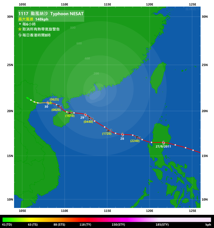
Percentile Ranks 百分等級:
Percentile rank among storms with #8 Signal (at compilation of this review)*: *This measures the relative wind strength in Hong Kong caused by this storm compared with others that share the same signal. 指標顯示此風暴相對於其他發出同樣信號的風暴為香港帶來之風力強度 For more information, please refer to Wind Speed Data for TCs that Have Affected Hong Kong. 更多資訊載於 影響香港氣旋之風速數據 頁 |
Overall: 總計: |
|
Moderate 中等 |
|||
| Component Ranks 分部等級 | ||||||
| Reference stations: 參考站: |
|
Moderately weak 中等偏弱 |
||||
| Victoria Harbour: 維多利亞港: |
|
Moderately strong 中等偏強 |
||||
| Urban: 市區: |
|
Moderate 中等 |
||||
| Offshore & high ground 離岸和高地: |
|
Moderate 中等 |
||||
IR imagery animation 紅外線雲圖動畫:
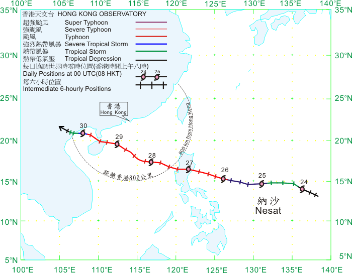
TC track from HKWW 本站的熱帶氣旋路徑圖:
TC track from HKO 天文台的熱帶氣旋路徑圖:
| Past HKWW Bulletins on NESAT 本站有關納沙的發佈 |
Please click here for bulletins on NESAT. 請按這裡。
| Storm Formation and Development 氣旋形成和發展 |
Unless otherwise stated, all times below are in Hong Kong Standard Time (UTC+8)
除非特別註明,下文時間均為香港標準時間 (協調世界時加 8 小時)
NESAT is the first tropical cyclone to necessitate the #8 tropical cyclone signal since KOPPU in 2009.
An area of low pressure developed some 500 km north of Yap on September 22. The system had decent spiraling structure at the early stages of formation. It was also the first storm in almost a month forecast to move west without recurving, as the subtropical ridge was expected to extend westward after the dissipation of ROKE. Still, early predictions by certain models like NGP and GFS depicted recurvature, but the more consistent performers like ECMWF projected a steady WNW track towards southern China, with some model runs indicating a direct hit on Hong Kong as a typhoon.
The JTWC issued a formation alert at 02 HKT on September 23, and upgraded the system into tropical depression 20W at 20 HKT. Initial forecast called for a stable westward motion under the southern periphery of the subtropical ridge, followed by a WNW track towards northern Luzon 4 days later as the ridge would then retreat. Such projections continued the next day, with more forecast tracks from agencies available as the JMA upgraded 20W into a tropical storm at 08 HKT on September 24. 20W was given the name NESAT. It was contributed by Cambodia, meaning fishing.
The subtropical ridge extended greatly to the west during the day --- by that night the western edge of the ridge had already reached Taiwan and Luzon Strait. Due to the high sea temperatures, NESAT intensified steadily. The JTWC estimated that NESAT carried winds of 50 knots, or the wind speeds of a minimal severe tropical storm.
NESAT moved faster than expected and it also started to move due west after noon on September 24. All these indicated that the subtropical ridge was indeed stronger than expected. With NESAT's fast pace and a strong ridge, model forecast started to shift NESAT's track west, from making landfall near Hong Kong to western Guangdong or even Hainan Island. Though, GFS still insisted that a more significant northward jog just west of Luzon would bring the storm to the Pearl River estuary. NESAT even dipped southward slightly in the small hours of September 25, making landfall at the mountainous Luzon inevitable. As it was almost certain that NESAT would enter the northern South China Sea, the Observatory started to put force 7 winds in their 7-day weather forecasts that day, indicating that a Strong Wind Signal would be quite likely later that week.
Intensification continued as NESAT entered an even warmer body of water. The JTWC upgraded NESAT into a typhoon on September 25, while other agencies that used 10 minute average wind speeds generally made the upgrade early on September 26. NESAT was only around 600 km from Manila at that time.
納沙是自 2009 年巨爵以來首個令天文台發出八號熱帶氣旋警告信號的風暴。
一個低壓區在 9 月 22 日於雅蒲島以北約 500 公里處發展,其旋捲性頗佳。隨著當時熱帶氣旋洛克遠離消散,副熱帶高壓脊西伸,這風暴亦是近一個月來第一個預料向西移而不會轉向的熱帶氣旋。雖然如此,部分數值預報模式如 NGP 和 GFS 均曾預測轉向,但發揮比較穩定的模式如 ECMWF 等則預料該低壓區將增強並向西北偏西穩定移動,趨向中國南部,部分時間更預測該低壓區會以颱風強度直趨香港。
JTWC 於 23 日上午 2 時對該低壓區發出熱帶氣旋形成警報,並於當晚 8 時將其升格為熱帶低氣壓 20W。初始預報指 20W 將在副高南沿穩定向西移動,五天後副高略為減弱令 20W 向西北偏西移,趨向呂宋北部。這樣的預測於翌日維持;而隨著日本氣象廳於 24 日早上 8 時升格 20W 為熱帶風暴,更多官方網站提供預測。20W 被命名為納沙,此名由柬埔寨提供,意思為捕魚。
副高於當天大舉西伸,24 日晚其西沿已到達台灣和呂宋海峽一帶。由於海溫較高,納沙穩定地增強,JTWC 估計其中心風力達 50 節,為強烈熱帶風暴下限。
納沙移動比預期快,亦於 24 日下午開始向正西移動,這意味著副高比預期強。由於納沙移速高而副高亦強,預報模式開始將納沙的路徑西移,由在香港附近登陸改為廣東西部甚至海南島。GFS 則仍然堅持預測納沙於呂宋以西將明顯西北移,令納沙得以靠近珠江口。納沙於 25 日凌晨甚至稍為南移,幾乎肯定登陸呂宋高山地區。由於納沙將很大機會橫過南海北部,香港天文台開始在其七天天氣預報中加入 7 級風速的預測,暗示該周較後時間或需發出強風信號。
納沙西移遇上更暖的海水,因而繼續增強。JTWC 於 25 日升格納沙為颱風,其他使用 10 分鐘平均風速為標準的氣象台則大多於 26 日早上升格。納沙當時已處於馬尼拉以東約 600 公里。

Figure 1 - NESAT at early stage of formation
圖 1 - 納沙形成初期

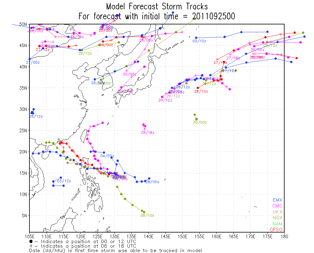
Figures 2a and 2b - Forecast tracks by different numerical models
圖 2a 及 2b - 各數值模式預測路徑

Figure 3 - Track predictions by various official agencies on September 24
圖 3 - 官方氣象台 9 月 24 日之預測路徑
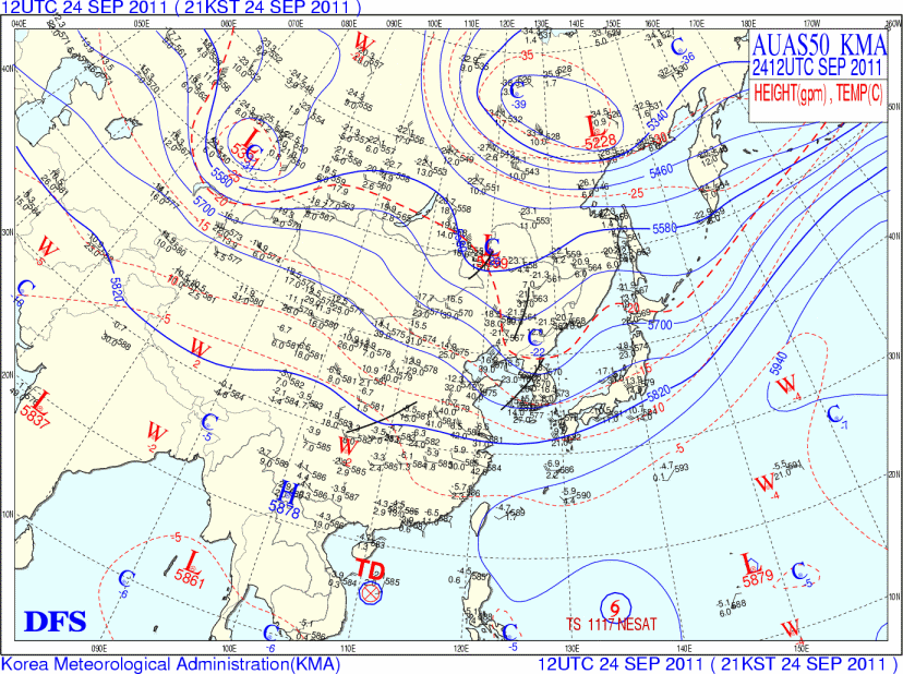
Figure 4 - 500 hPa upper-level weather map at 20 HKT, September 24
圖 4 - 9 月 24 日晚上 8 時之 500 百帕高空天氣圖

Figure 5 - Wind field scan showing NESAT's well-defined circulation
圖 5 - 風場掃描圖顯示納沙環流完整
| Reaching Luzon and Entering South China Sea 抵達呂宋和進入南海 |
The subtropical ridge lifted north slightly and allowed NESAT to travel WNW on September 26. At this stage essentially all agencies had adjusted their track forecast with second landfall at eastern Hainan.
NESAT managed to develop an eye later on September 26 and it became apparent on IR imageries that night. It made landfall at eastern Luzon at around 07 HKT on September 27 with intensity estimates ranging from 75 knots (139 km/h, HKO) to 105 knots (194 km/h, JTWC). As usual the eye disappeared quickly after landfall, and the storm's vertical alignment was destroyed as it passed through the mountains. The strong subtropical ridge is maintaining NESAT's momentum and allowed it to reach the South China Sea at around 17 HKT that day. NESAT's centre became difficult to track as it was hard to determine if the low-level circulation was at the same location as the upper-level circulation. Nevertheless, since it was close to Hong Kong's 800-km boundary, the Observatory mentioned that it would consider issuing the Standby Signal that night.
The #1 Standby Signal was issued at 22:40 HKT, when NESAT was 760 km southeast of Hong Kong. Since NESAT remained as a typhoon, it was understandable that the signal was issued soon after NESAT breached the boundary. From satellite imageries it could be seen that moisture kept spiraling into NESAT from the southern periphery, and this allowed the storm to maintain appreciable strength.
9 月 26 日副高稍為北跳,納沙重新向西北偏西移動。這時幾乎所有機構已將納沙第二次登陸點修訂至海南東部。
納沙於 26 日較後時間發展出風眼,其後風眼於紅外線衛星雲圖上可清楚見到。它於 27 日上午 7 時左右登陸呂宋東部,強度估算為 75 節 (每小時 139 公里,香港天文台) 至 105 節 (每小時 194 公里,聯合颱風警報中心)。與其他氣旋一樣,登陸呂宋令納沙的風眼於數小時內消失,風暴垂直結構亦隨它橫過高山而被破壞。強勁的副高令納沙保持較快的移速,它於當天下午約 5 時離開菲律賓,進入南海。由於高低層環流未必重疊,釐定納沙的中心位置變得更難,但仍大約可以見到納沙即將進入香港 800 公里範圍。天文台下午表示將於晚間考慮發出一號戒備信號。
一號戒備信號於當晚 10 時 40 分發出,當時納沙於香港東南約 760 公里。由於納沙離開呂宋後仍然維持颱風強度,這距離是可以理解的。從衛星雲圖上可見納沙南部不斷捲入濕潤的氣流作能量,令其保持一定強度。


Figures 6a and 6b - (left) NESAT about to make landfall at Luzon; (right) NESAT entering South China Sea
圖 6a 及 6b - (左) 納沙即將於呂宋登陸;(右) 納沙進入南海

Figure 7 - Track predictions by various official agencies on September 27
圖 7 - 官方氣象台 9 月 27 日之預測路徑
| Traversing South China Sea 橫過南海 |
NESAT was still moving W/WNW after entering South China Sea, but its wind radius was expanding. This could be seen from HKO's tropical cyclone warning for shipping where the estimated gale radius was increased from 180 NM (333 km) to 210 NM (389 km) in the morning of September 28. Locally, winds were strengthening steadily in the morning, prompting the Observatory to consider the Strong Wind Signal in the afternoon. NESAT also started to take a more northerly track in the afternoon. The #3 Strong Wind Signal was issued at 17:20 HKT when NESAT was 540 km SSE of Hong Kong. It was very rare for a storm at such distance to necessitate the Strong Wind Signal, especially in recent years. In the hour between 16:31 and 17:30 HKT, offshore stations like Cheung Chau, Green Island and Waglan Island recorded sustained strong force winds.
The first rainband associated with NESAT arrived at Hong Kong near 18:30 HKT. Rain was recorded in most areas of the territory, but intensity was generally light. In the next few hours after the Strong Wind Signal was issued, local winds strengthened appreciably. More stations like Chek Lap Kok, Sai Kung and Sha Chau started to record strong force winds at 21 HKT, while winds at the stations mentioned in the last paragraph had already reached gale force. Initially, the Observatory projected that NESAT's northward track component would diminish and the storm would have a closest point of approach of around 400 km. Under this scenario, the chance of higher signals that night would be low unless NESAT strengthened or had a more northerly track. As another hedge, the Observatory mentioned that it would monitor NESAT's movement closely, indicating that a higher signal could not be ruled out completely.
In fact, the ridge north of NESAT weakened a bit and NESAT's motion remained steady. It entered the 400-km circle at around 01 to 02 HKT on September 29. Winds at various stations also continued to strengthen. Two reference stations, Cheung Chau and Sai Kung, registered gale force winds near midnight or 01 HKT, while Chek Lap Kok, another reference station, was on the verge. Because of the very wide gale wind radius, strong easterly winds were observed in many areas (unlike in the case where storms had steep wind speed differential that would make parts of the territory extremely windy while very weak winds at others). Due to such continual increase in wind speeds, the Observatory remarked that a higher signal would be considered in its 01:45 HKT bulletin. The Pre-no. 8 Special Announcement, however, was issued at 03:10 HKT, announcing that the Gale or Storm Signal would be issued by 05:30 HKT the latest.
Chek Lap Kok eventually reached gale force winds after 03 HKT, and by then gales were observed in three out of the 8 reference stations (not at the same time though, as winds at Sai Kung never reached gale force since 02:10 HKT). Meanwhile, Ngong Ping registered hurricane force winds multiple times during the night, with gusts in excess of 160 km/h. The Observatory was rather late at changing the wind speed description in their forecasts --- it was only as late as 03:45 HKT did they eventually acknowledge that force 8 winds would be reached in urban areas. It was also worth mentioning that Huangmaozhou, an island just south of Hong Kong, recorded force 11 easterly winds (storm force) as indicated in the south china coastal waters weather report at 03:30 HKT.
News about the impending #8 Signal was spread across the city by various television and radio channels. However, most citizens were asleep and unaware of this, having the impression that the signal was not likely given NESAT's (large) distance to Hong Kong. Not long after the Pre-no. 8 warning was issued, it was announced that cargo handling would be suspended at 05 HKT.
The #8 Southeast Gale or Storm Signal was issued at 04:40 HKT, almost one hour earlier than their prespecified deadline. At that time winds were still coming from the east or east-northeast, but the wind direction was expected to change to southeast during daytime. Immediately after the announcement, the Education Bureau suspended classes of all day schools. Public transport essentially came to a halt, but the MTR was maintaining every train in 10 minutes at most lines. Ferry services within the territory as well as those between Hong Kong and Macau were also suspended soon after the issuance of the #8 Signal. Macau issued the #8 NE Signal at 06:00 HKT, which was replaced by the #8 SE Signal at 10:30 HKT.
Winds weakened at around 06 HKT, but strengthened again near 08 HKT. Some stations recorded the strongest winds shortly after 08 HKT, but for others winds did not strengthen that much as wind direction started to turn to SE. Only very few high altitude stations managed to reach sustained storm force winds; this probably indicates that although the gale radius was wide, the storm radius was a lot smaller.
納沙進入南海後繼續向西至西北偏西移動,但其風圈則逐漸擴闊。天文台為船舶提供的熱帶氣旋警告中估算納沙的烈風圈半徑在 9 月 28 日上午由 180 海里 (333 公里) 增至 210 海里 (389 公里)。本地風勢上午穩步上揚,天文台隨即表示將於下午考慮改發三號強風信號。納沙路徑中午過後出現較大向北分量。天文台最終於下午 5 時 20 分發出三號強風信號,當時納沙於香港東南偏南約 540 公里處。熱帶氣旋距本港逾 500 公里而令天文台發出三號信號是相對地罕見的,尤以近年為甚。由下午 4 時 31 分至 5 時 30 分的一小時內,離岸氣象站如長洲、青洲和橫瀾島均錄得持續強風。
與納沙相關連的首條雨帶在約 6 時 30 分到達本港。香港大多數地區錄得降雨,但雨勢不大。三號信號發出後的首數小時,本港風勢明顯增強,赤鱲角、西貢和沙洲亦於晚上 9 時開始錄得強風,而先前提到的測風站已達烈風風速。初時天文台預計納沙路徑的偏北分量將減少,風暴將於本港約 400 公里處掠過。在此情況,除非納沙增強或路徑偏北,否則當晚改發更高信號的機會不大。但由於納沙路徑確有比預期北之勢,天文台稍後表示將密切留意納沙的發展,似乎暗示更高信號未能完全排除。
由於納沙以北的脊場稍為減弱,納沙保持較北的移動路徑。它於 29 日上午 1 至 2 時進入本港 400 公里範圍,香港多處風勢進一步增強。八個參考站中的其中兩個 --- 長洲和西貢 --- 在午夜至 1 時左右錄得烈風,而另一參考站赤鱲角亦測得接近烈風風速。由於納沙烈風風圈廣闊,本港多處吹偏東強風 (不像風圈較窄的熱帶氣旋只令部分地區吹強風而其他地方風勢微弱)。由於風勢強勁且有繼續增強之勢,天文台於凌晨 1 時 45 分表示將於未來數小時考慮改發更高熱帶氣旋警告信號,而預警八號熱帶氣旋警告信號之特別報告則於 3 時 10 分發出,表示上午 5 時 30 分或以前將改發八號信號。
赤鱲角終在上午 3 時過後錄得烈風,即八個參考站中有三個已曾錄得烈風風速 (但並不是同時達標,因西貢自上午 2 時 10 分已再沒有錄得烈風)。另一邊廂,昂坪於晚間多次錄得颶風風速,陣風更達每小時 160 公里。天文台於天氣報告中的風速描述則較遲修訂,在 3 時 45 分才表示市區出現 8 級風。值得一提的是本港以南的黃茅洲於 3 時 30 分發出的華南海域天氣報告中指出正吹 11 級東風,接近暴風上限。
八號信號預警發出後,各大傳媒紛紛發放相關天氣消息,但由於大部分市民已經入睡,它們的印象大多還停留在較早時天文台指出 (當晚) 更高信號機會不大的字眼。其後,多間貨櫃碼頭公司表示將於上午 5 時停止所有貨櫃交收。
八號東南烈風或暴風信號於上午 4 時 40 分發出,比預計期限早接近一小時。當時風向仍介乎東至東北偏東,但預料將於日間轉向東南。教育局隨即宣佈所有日校將停課一天。大多數公共交通工具停止運作,但港鐵主要線路仍維持每 10 分鐘一班列車。港內及港澳渡輪服務亦於八號信號發出後不久停止。澳門則先於上午 6 時發出八號東北風球,繼而於上午 10 時 30 分改發八號東南風球。
本地風力於上午 6 時稍為減弱,但在 8 時再度加強。部分氣象站於 8 時左右錄得最強風速,但由於風向轉變,其它則未達先前高位。只有很少數站能錄得持續暴風風力 (主要為高地站),這可能顯示雖然納沙烈風圈廣闊,暴風圈則明顯較細。

Figure 8 - HKO's tropical cyclone warning for shipping depicts a wide gale radius (pink)
圖 8 - 天文台為船舶提供的熱帶氣旋警告中顯示納沙烈風圈 (粉紅色) 頗大
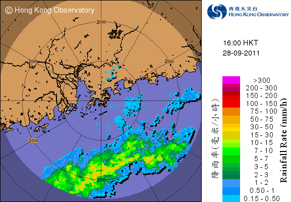
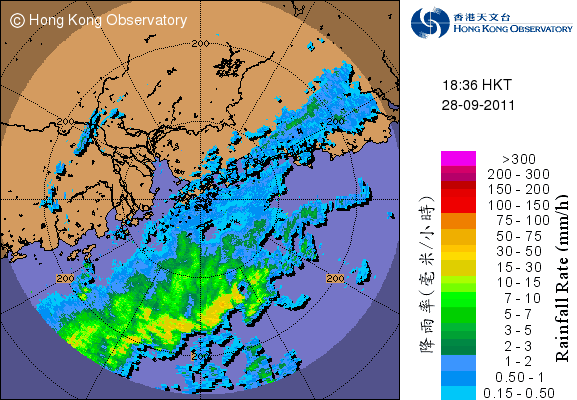
Figures 9a and 9b - Rainbands associated with NESAT hitting Hong Kong
圖 9a 及 9b - 與納沙相關連的雨帶影響香港


Figures 10a to 10d - Wind speed time series at Chek Lap Kok, Cheung Chau, Ngong Ping and Sai Kung
圖 10a 至 10d - 赤鱲角、長洲、昂坪和西貢的風速時間序列圖


Figures 11a to 11d - Local weather elements at different stations
圖 11a 至 11d - 本港不同氣象站之氣象要素

Figure 12 - Sea level pressure at Cheung Chau
圖 12 - 長洲之海平面氣壓

Figure 13 - NESAT at closest approach to Hong Kong
圖 13 - 納沙於最接近香港之位置


Figures 14a and 14b - Satellite images at 02 and 14 HKT, September 29
圖 14a 及 14b - 9 月 29 日上午 2 時和下午 2 時之衛星雲圖

Figure 15 - Calculated wind field at 08 HKT, September 29. Notice that NESAT's gale radius was very large especially in the northeastern quadrant
圖 15 - 9 月 29 日上午 8 時估算所得風場圖,留意納沙的烈風圈非常廣闊,尤其是東北面
| Weakening Winds 風勢減弱 |
NESAT gradually moved to the southwest of Hong Kong and made its closest point of approach in the morning when it was 350 km away. A major rainband reached Hong Kong at about 10 HKT. However it was also short-lived and did not produce high amount of precipitation. Winds started to diminish after 10 HKT, but persistent gales were observed at the offshore stations. For this reason the Observatory said in their tropical cyclone report that the #8 Signal would remain in force for most of the time during the day (i.e. daytime). This made September 29 the first day since August 22, 2008 (tropical cyclone NURI) that most citizens enjoyed a full day off.
The distance between NESAT and Hong Kong started to increase after 11 HKT. Within the next two hours, winds eased substantially and gales were confined to the southern part of the territory. The Observatory mentioned in their 13:45 HKT report that the Strong Wind Signal would be issued in a few hours' time. That signal was eventually issued at 16:10 HKT, replacing the #8 Signal that was in force for almost 12 hours. Public transport services resumed at around 17 HKT, while cargo handling was resumed at 19 HKT. Although winds had subsided, the Observatory warned that flooding might occur at low-lying areas during high tide at around 23 HKT that night.
As for NESAT's track, it made landfall at Wenchang, Hainan at around 14:30 HKT. The CMA briefly upgraded NESAT into a severe typhoon prior to landfall, while other agencies generally recognized NESAT as a typhoon. It resumed its westward movement and hit Haikou later that day. The CMA also mentioned that another landfall was made at Xuwen, Guangdong at around 21:15 HKT that night, meaning that the storm had passed through the Qiongzhou Strait. Although it was tracking further away from Hong Kong, strong winds were observed at a number of stations long after the re-issuance of the #3 Signal. The Strong Wind Signal remained in force until 00:20 HKT on September 30, which was replaced by the Standby Signal. All signals were cancelled at 06:25 HKT.
納沙於 29 日早上到達最接近香港的位置 (約 350 公里) 後開始遠離本港。另一條主要雨帶在 29 日上午 10 時到達本港,但影響時間不長,總雨量亦不高。各區風勢於上午 10 時過後明顯減弱,但離岸仍持續地錄得烈風。天文台因此於熱帶氣旋報告中表示八號信號將於日間大部分時間生效,這令 9 月 29 日成為自 2008 年 8 月 22 日熱帶氣旋鸚鵡襲港以來的首天全日停工停課。
納沙與香港的距離於上午 11 時開始明顯增加。其後兩小時,風力進一步放緩,烈風只限於本港南部出現。天文台在下午 1 時 45 分宣佈將於數小時內改發三號強風信號。該信號於下午 4 時 10 分發出,取代發出接近半日的八號信號。公共交通服務於下午 5 時左右逐步恢復正常,貨櫃交收亦於下午 7 時恢復。雖然風力已明顯減弱,天文台亦提醒市民低窪地區可能於晚上 11 時漲潮時出現水浸。
路徑方面,納沙於約下午 2 時 30 分在海南文昌市登陸。中國氣象部門於納沙登陸前將其升格為強颱風,而其他機構則大多維持颱風強度。納沙轉向偏西,其後吹襲海口。納沙於晚上 9 時 15 分在廣東徐聞再度登陸,亦即納沙早前曾通過瓊州海峽。雖然納沙已遠離本港,但三號信號發出長時間後本港部分地區仍錄得強風。該信號最終於 30 日凌晨零時 20 分被一號戒備信號取代,而所有熱帶氣旋警告信號則於上午 6 時 25 分取消。

Figure 16 - NESAT making landfall at Hainan
圖 16 - 納沙於海南登陸
| Final Landfall and Dissipation 最後一次登陸與消散 |
NESAT entered the Gulf of Tonkin at around midnight on September 30. Due to land interaction and previous landfall at Hainan, the storm's structure deteriorated and clouds were getting thinner. It was downgraded into a severe tropical storm during the day, and further into a tropical storm in the afternoon. It made its final landfall at northern Vietnam near sunset, and scored a direct hit at Hanoi. The storm gradually lost its source of energy and dissipated early on October 1.
納沙在 9 月 30 日約凌晨時份進入北部灣。受登陸海南和地形影響,納沙的結構轉差,雲層亦開始轉薄。它在日間減弱為強烈熱帶風暴,午後更被降格為熱帶風暴。納沙在 30 日日落前後登陸越南北部,並直趨河內。它逐步失去能量,於 10 月 1 日早上消散。
| Damage and Disruptions Caused by NESAT 納沙帶來的破壞和擾亂 |
NESAT caused widespread damage in Hong Kong, but fortunately no one was severely injured.
- A floating dock got loose near Chai Wan and drifted towards Heng Fa Chuen, eventually hitting the embankment just outside Block 49 of the estate. The dock was damaged and water filled part of it, making it difficult to be towed away. A protrusion of the barge on the floating dock swayed towards the wall of the housing estate, causing residents there to evacuate briefly in the morning on September 29 when the #8 Signal was just issued.
- Because of the "sudden" announcement of the #8 Signal, a number of passengers were stranded at the Hong Kong - Macau Ferry Terminal at Sheung Wan, most of which were visitors from the mainland. Ferry services resumed only after the #8 Signal at Macau was cancelled, or at 18:30 HKT.
- It was the first time that the stock market was closed for the whole day on the futures settlement day. It was decided that those contracts would be settled on September 30.
- On September 29, 489 flights arriving or departing Hong Kong were delayed, 41 were cancelled while 40 were diverted to other airports.
- More than 400 cases of falling trees and scaffolding were reported. A few glass panels at Heng Seng Bank Headquarters in Central were found shattered and fell off the street.
- Classes of all day schools as well as some public examinations were cancelled. The dates for submitting Primary One application forms for discretionary places were also postponed.
納沙為香港帶來廣泛破壞和影響,可幸沒有人因此嚴重受傷。
- 柴灣一個浮塢錨鍊斷裂,浮塢於海面漂浮至杏花邨 49 座對開岸邊,浮塢損毀入水,使其更難被拖走。浮塢上一艘工程船伸出的起卸裝備傾向樓宇一側,幾乎打中牆身,居民於八號信號發出後不久曾短暫疏散。
- 由於八號信號發出相對突然,部分乘客於港澳碼頭滯留,其中多數為內地遊客。渡輪服務於 9 月 29 日下午 6 時 30 分澳門改發三號風球後恢復。
- 此為首次在期指結算日整日停市,港交所宣佈結算日將順延至 9 月 30 日。
- 機管局宣佈,9 月 29 日共有 489 班離港及抵港航班延遲,41 班取消,另外 40 班轉飛其他機場。
- 當局接獲超過 400 宗塌樹和棚架報告,中環恆生銀行總行數塊玻璃幕牆爆裂並飛墮地面。
- 所有日校停課,部分公開考試亦需取消。遞交小一自行分配學位申請表的日期亦因颱風關係順延。

Figure 17 - The floating dock and barge mentioned above. Image from Apple Daily.
圖 17 - 在海面漂浮的浮塢和工程船。圖片取自蘋果日報

Figure 18 - Glass panels missing at Heng Seng Bank Headquarters. Image from Apple Daily.
圖 18 - 恆生銀行總行玻璃幕牆脫落。圖片取自蘋果日報
| Winds Recorded at Reference Stations 參考站所錄得的風速 |
| Station 風速站 |
Max. 10-min avg. wind speed 最高十分鐘平均風速 |
Beaufort classification 蒲福氏風級分類 |
| Chek Lap Kok 赤鱲角 | 78 km/h | GALE 烈風 |
| Cheung Chau 長洲 | 85 km/h | GALE 烈風 |
| Kai Tak 啟德 | 53 km/h | STRONG 強風 |
| Sai Kung 西貢 | 66 km/h | GALE 烈風 |
| Sha Tin 沙田 | 36 km/h | Fresh 清勁 |
| Ta Kwu Ling 打鼓嶺 | 35 km/h | Fresh 清勁 |
| Tsing Yi (SHL) 青衣蜆殼油庫 | 39 km/h | Fresh 清勁 |
| Wetland Park 濕地公園 | 38 km/h | Fresh 清勁 |
| Number of stations recording at least STRONG force (force 6 - 7) winds: | 4 |
| Number of stations recording at least GALE force (force 8 - 9) winds: | 3 |
| Number of stations recording at least STORM force (force 10 - 11) winds: | 0 |
| Number of stations recording HURRICANE force (force 12) winds: | 0 |
| 錄得 強風 (6 - 7 級) 或更高風速的站數: | 4 |
| 錄得 烈風 (8 - 9 級) 或更高風速的站數: | 3 |
| 錄得 暴風 (10 - 11 級) 或更高風速的站數: | 0 |
| 錄得 颶風 (12 級) 風速的站數: | 0 |
| Charts and Figures 各項數據 |
Table 1: Track data from HKWW:
表一 : 香港天氣觀測站之路徑資料
YYMMDDZZ Lat Long Wind |
Table 2: Maximum gust and hourly average wind speed recorded in Hong Kong from HKO:
表二 : 香港天文台公佈的各站最高每小時平均風力和陣風數據
| Station | Maximum Gust |
Maximum Hourly Mean Wind |
||||||
Direction |
Speed (km/h) |
Date/Month |
Time |
Direction |
Speed (km/h) |
Date/Month |
Time |
|
| Bluff Head (Stanley) | ESE |
103 |
29/9 |
03:04 |
SE |
58 |
29/9 |
11:00 |
| Central Pier | E |
94 |
29/9 |
04:04 |
E |
63 |
29/9 |
05:00 |
| Cheung Chau | -
|
121
|
29/9
|
10:05
|
E |
79 |
29/9 |
05:00 |
E |
79 |
29/9 |
11:00 |
|||||
| Cheung Chau Beach | E |
137 |
29/9 |
02:32 |
E |
85 |
29/9 |
05:00 |
| Green Island | - |
122 |
29/9 |
04:34 |
- |
76 |
29/9 |
03:00 |
| Hong Kong International Airport | E |
110 |
29/9 |
03:15 |
E |
62 |
29/9 |
09:00 |
| Kai Tak | ENE |
96 |
29/9 |
02:31 |
E |
47 |
29/9 |
18:00 |
| King's Park | E |
87 |
29/9 |
05:27 |
E |
34 |
29/9 |
05:00 |
| Lau Fau Shan | E |
104 |
29/9 |
02:41 |
E |
49 |
29/9 |
04:00 |
| Ngong Ping | ENE |
167 |
29/9 |
03:15 |
ENE |
124 |
29/9 |
04:00 |
| North Point | E
|
96
|
29/9
|
02:14
|
E |
51 |
29/9 |
03:00 |
E |
51 |
29/9 |
05:00 |
|||||
| Peng Chau | E |
110 |
29/9 |
02:11 |
E |
76 |
29/9 |
03:00 |
| Ping Chau | E |
121 |
29/9 |
04:12 |
E |
30 |
29/9 |
05:00 |
| Sai Kung | ENE |
104 |
29/9 |
02:05 |
E |
58 |
29/9 |
05:00 |
| Sha Chau | E |
85 |
29/9 |
04:25 |
SE |
58 |
29/9 |
19:00 |
| Sha Lo Wan | E |
96 |
29/9 |
05:00 |
E |
56 |
29/9 |
05:00 |
| Sha Tin | N |
79 |
29/9 |
03:17 |
NE |
27 |
29/9 |
04:00 |
| Shek Kong | E |
96 |
29/9 |
14:13 |
E |
36 |
29/9 |
09:00 |
| Star Ferry (Kowloon) | ESE
|
92
|
29/9
|
18:19
|
E |
54 |
29/9 |
05:00 |
E |
54 |
29/9 |
10:00 |
|||||
| Ta Kwu Ling | E
|
70
|
29/9
|
16:42
|
ENE |
27 |
29/9 |
04:00 |
ENE |
27 |
29/9 |
06:00 |
|||||
| Tai Mei Tuk | E |
108 |
29/9 |
10:12 |
E |
77 |
29/9 |
05:00 |
| Tai Mo Shan | ESE |
149 |
29/9 |
09:47 |
SE |
96 |
29/9 |
15:00 |
| Tap Mun | E |
96 |
29/9 |
02:03 |
E |
49 |
29/9 |
01:00 |
| Tate's Cairn | E |
131 |
29/9 |
04:58 |
E |
87 |
29/9 |
05:00 |
| Tsak Yue Wu | ENE
|
62
|
29/9
|
03:22
|
E |
20 |
29/9 |
03:00 |
ENE |
20 |
29/9 |
05:00 |
|||||
| Tseung Kwan O | ENE |
72 |
29/9 |
02:09 |
NE |
25 |
29/9 |
03:00 |
| Tsing Yi Shell Oil Depot | ESE |
79 |
29/9 |
07:46 |
E |
31 |
29/9 |
09:00 |
| Tuen Mun Government Offices | SE |
96 |
29/9 |
18:01 |
SE |
36 |
29/9 |
19:00 |
| Waglan Island | E |
110 |
29/9 |
01:14 |
E |
83 |
29/9 |
03:00 |
| Wetland Park | E |
77 |
29/9 |
04:47 |
E |
31 |
29/9 |
04:00 |
| Wong Chuk Hang | E |
96 |
29/9 |
07:04 |
E |
41 |
29/9 |
03:00 |
Table 3: Rainfall (in millimetres) contributed by NESAT from HKO (figures in brackets are based on incomplete hourly data):
表三 : 香港天文台公佈的各站雨量資料 (方括號內之數據由不完整之每小時資料擷取)
Station |
27-Sep |
28-Sep |
29-Sep |
30-Sep |
Total (mm) |
|
| Hong Kong Observatory | Trace |
2.5 |
30.8 |
2.7 |
36.0 |
|
| Hong Kong International Airport (HKA) | 0.0 |
3.7 |
53.6 |
28.3 |
85.6 |
|
| N26 | Cheung Chau | 0.0 |
3.0 |
46.0 |
13.0 |
62.0 |
| N05 | Fanling | 0.0 |
8.0 |
20.0 |
13.5 |
41.5 |
| N13 | High Island | 0.0 |
3.5 |
9.0 |
3.0 |
15.5 |
| K04 | Jordan Valley | 0.0 |
3.0 |
29.5 |
1.5 |
34.0 |
| N06 | Kwai Chung | 0.0 |
4.5 |
45.0 |
1.0 |
50.5 |
| H12 | Mid Levels | 0.0 |
4.0 |
38.5 |
13.0 |
55.5 |
| H21 | Repulse Bay | 0.0 |
3.5 |
34.5 |
9.5 |
47.5 |
| N09 | Sha Tin | 0.0 |
7.5 |
10.0 |
7.5 |
25.0 |
| H19 | Shau Kei Wan | 0.0 |
2.0 |
25.0 |
1.0 |
28.0 |
| SEK | Shek Kong | 0.0 |
6.0 |
68.0 |
7.0 |
81.0 |
| K06 | So Uk Estate | 0.0 |
4.0 |
49.5 |
0.5 |
54.0 |
| R31 | Tai Mei Tuk | 0.0 |
7.0 |
11.5 |
10.5 |
29.0 |
| R21 | Tap Shek Kok | 0.0 |
6.0 |
59.5 |
8.5 |
74.0 |
| N17 | Tung Chung | 0.0 |
5.5 |
63.5 |
31.0 |
100.0 |
| R27 | Yuen Long | 0.0 |
5.0 |
59.0 |
6.5 |
70.5 |
Last Accessed 最近訪問日期: Thu Apr 25 2024 18:37:56 HKT
Last Modified 最近修訂日期: Mon Jul 24 2023
