TC Watch / 熱帶氣旋 > Latest TC Info 最新熱帶氣旋資訊 [Refresh 更新]

Quick links 快速連結: Current Storm Info 實時氣旋資料 Past Storm Info 過去氣旋資料
HKO Storm Info 天文台之熱帶氣旋資訊 TC Archive 熱帶氣旋資料庫
Official TC Track Info 官方熱帶氣旋路徑資料 Selected TC Review 重要熱帶氣旋回顧
Tracks from Non-Governmental Agencies 民辦網站預測路徑圖 TC Finder 熱帶氣旋尋找工具
Active Tropical Cyclone(s) 正活躍之熱帶氣旋

Current TC Map 即時氣旋資訊Current TC information

Tropical Cyclone Report 熱帶氣旋報告 [Our partner site's TC report 按此看友站的氣旋報告]

1. 13W (KIROGI 鴻雁)

Name of System 系統名稱

TS KIROGI 熱帶風暴 鴻雁


JTWC No. / Int'l No. JTWC 編號 / 國際編號 13W / 1212
Bulletin Number 發佈編號 #6 FINAL BULLETIN 最後發佈
Time of Report 報告時間

2012/08/10, 19:00 HKT (11:00 UTC)

Time of Observation 觀測時間 2012/08/10, 14:00 HKT (06:00 UTC)
Position 位置 44.2°N, 148.1°E
Maximum Gust 最高陣風 50 knots 節 (90 km/h 公里每小時)
1-min. Average Wind Speed 1分鐘平均風速 40 knots 節 (75 km/h 公里每小時)
10-min. Average Wind Speed 10分鐘平均風速 35 knots 節 (65 km/h 公里每小時)
Pressure 氣壓 996 hPa 百帕斯卡
Past 6-hr Movement 過去6小時移向和移速 NNW 西北偏北 (336°) at 29 knots 節 (53 km/h 公里每小時)
Area(s) affected 受影響地區 Kuril Islands 千島群島

Forecast Track 預測路徑圖

Forecast Positions 預測位置資料

Tau
時間差
HK Time
香港時間
Lat.
緯度
Long.
經度
Movement
移動速度和方向
1-min Average Strength
一分鐘平均強度
t+008/10 (Fri) 14:0044.2°N148.1°EN 北 (355°) 54 km/h40 kt (74 km/h)TS 熱帶風暴
t+1208/11 (Sat) 02:0050.0°N147.3°EN/A40 kt (74 km/h)Ext Cyclone 溫帶氣旋

Overview 總覽

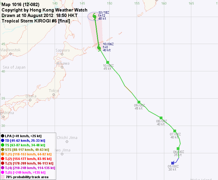
KIROGI is now approaching the Kuril Islands. At 14 HKT, KIROGI was centred about 560 km (300 NM) ENE of Sapporo.

鴻雁正趨向千島群島。在下午 2 時,鴻雁集結在札幌東北偏東約 560 公里 (300 海里)。

TC Naming 氣旋命名

KIROGI is the third name in the tropical cyclone name list. It was contributed by North Korea, meaning wild goose. This name was used in 2000 and 2005.

鴻雁為熱帶氣旋名稱列表中第 3 個名字,由北韓提供。此名字曾於 2000 及 2005 年使用。

Movement Analysis 路徑分析

KIROGI will move NNW to N along the western periphery of the subtropical ridge.

鴻雁將沿副熱帶高壓脊西部向北或西北偏北移動。

Intensity Analysis 強度分析

Current T-number: T2.5/3.0/W0.5/18 HRS
As KIROGI travels north, increase in wind shear will accelerate its transition into an extratropical cyclone.

現時的 T 號碼: T2.5/3.0/W0.5/18 HRS
隨鴻雁北上,風切開始增加,預料將加快溫帶氣旋轉化過程。

Effects on Hong Kong 對香港的影響

No threat to Hong Kong is expected within the next 72 hours.

鴻雁於未來的 72 小時將不會對香港構成任何影響。

Next Update 下次更新

This is the final bulletin on KIROGI.

這是本站對鴻雁的最後一次發佈。

Other Images 其他圖像
JTWC Track 聯合颱風警報中心路徑圖
JMA Track 日本氣象廳路徑圖
HKO Satellite 香港天文台衛星圖
HKO Track 香港天文台路徑圖
Probabilities of TC Signals from HKO 香港天文台 (已) 發出 / 取消熱帶氣旋警告信號的機率
N/A 不適用


Past Bulletins (click on the bulletin no. for the contents) 過往報告 (請按發佈編號顯示內容)

+13W (KIROGI 鴻雁) Bulletin 發佈 #5 (2012/08/09, 22:15 HKT)

Name of System 系統名稱

TS KIROGI 熱帶風暴 鴻雁


JTWC No. / Int'l No. JTWC 編號 / 國際編號 13W / 1212
Bulletin Number 發佈編號 #5
Time of Report 報告時間

2012/08/09, 22:15 HKT (14:15 UTC)

Time of Observation 觀測時間 2012/08/09, 20:00 HKT (12:00 UTC)
Position 位置 37.3°N, 152.8°E
Maximum Gust 最高陣風 55 knots 節 (100 km/h 公里每小時)
1-min. Average Wind Speed 1分鐘平均風速 45 knots 節 (85 km/h 公里每小時)
10-min. Average Wind Speed 10分鐘平均風速 40 knots 節 (75 km/h 公里每小時)
Pressure 氣壓 992 hPa 百帕斯卡
Past 6-hr Movement 過去6小時移向和移速 NW 西北 (322°) at 17 knots 節 (31 km/h 公里每小時)
Area(s) affected 受影響地區 N/A 不適用

Forecast Track 預測路徑圖

Forecast Positions 預測位置資料

Tau
時間差
HK Time
香港時間
Lat.
緯度
Long.
經度
Movement
移動速度和方向
1-min Average Strength
一分鐘平均強度
t+0 08/09 (Thu) 20:00 37.3°N 152.8°E NNW 西北偏北 (331°) 39 km/h 45 kt (83 km/h) TS 熱帶風暴
t+12 08/10 (Fri) 08:00 40.9°N 150.1°E NNW 西北偏北 (342°) 44 km/h 45 kt (83 km/h) TS 熱帶風暴
t+24 08/10 (Fri) 20:00 45.4°N 148.0°E N/A 40 kt (74 km/h) Subtropical Low 副熱帶低壓

Overview 總覽

KIROGI continued to move NW. At 20 HKT, KIROGI was centred about 1160 km (630 NM) ESE of Sapporo.

鴻雁繼續向西北移動。在下午 8 時,鴻雁集結在札幌東南偏東約 1160 公里 (630 海里)。

TC Naming 氣旋命名

KIROGI is the third name in the tropical cyclone name list. It was contributed by North Korea, meaning wild goose. This name was used in 2000 and 2005.

鴻雁為熱帶氣旋名稱列表中第 3 個名字,由北韓提供。此名字曾於 2000 及 2005 年使用。

Movement Analysis 路徑分析

The subtropical ridge northeast of KIROGI is NW-SE oriented and this should allow KIROGI to move NW to NNW.

鴻雁東北方的副熱帶高壓脊呈西北-東南向,預料鴻雁將向西北至西北偏北移動。

Intensity Analysis 強度分析

Current T-number: T3.0/3.0/D0.5/24 HRS
Wind shear near KIROGI is not high, but sea temperatures are rather low. It appears that KIROGI will gradually turn into a subtropical low as it travels further north where water temperatures cannot sustain tropical cyclone development.

現時的 T 號碼: T3.0/3.0/D0.5/24 HRS
鴻雁附近風切不高,但海溫偏低。隨著鴻雁北移,其所在之處海溫將不足以支持熱帶氣旋發展,風暴或會轉化為一副熱帶低壓。

Effects on Hong Kong 對香港的影響

No threat to Hong Kong is expected within the next 72 hours.

鴻雁於未來的 72 小時將不會對香港構成任何影響。

Next Update 下次更新

2012/08/10 (Fri 五), night 晚間 (or earlier 或更早)

Other Images 其他圖像
JTWC Track 聯合颱風警報中心路徑圖
JMA Track 日本氣象廳路徑圖
HKO Satellite 香港天文台衛星圖
HKO Track 香港天文台路徑圖
Probabilities of TC Signals from HKO 香港天文台 (已) 發出 / 取消熱帶氣旋警告信號的機率
N/A 不適用

+13W (KIROGI 鴻雁) Bulletin 發佈 #4 (2012/08/08, 18:15 HKT)

Name of System 系統名稱

TS KIROGI 熱帶風暴 鴻雁


JTWC No. / Int'l No. JTWC 編號 / 國際編號 13W / 1212
Bulletin Number 發佈編號 #4 REISSUED 重新發佈
Time of Report 報告時間

2012/08/08, 18:15 HKT (10:15 UTC)

Time of Observation 觀測時間 2012/08/08, 14:00 HKT (06:00 UTC)
Position 位置 32.0°N, 158.4°E
Maximum Gust 最高陣風 50 knots 節 (90 km/h 公里每小時)
1-min. Average Wind Speed 1分鐘平均風速 40 knots 節 (75 km/h 公里每小時)
10-min. Average Wind Speed 10分鐘平均風速 35 knots 節 (65 km/h 公里每小時)
Pressure 氣壓 998 hPa 百帕斯卡
Past 6-hr Movement 過去6小時移向和移速 WNW 西北偏西 (303°) at 11 knots 節 (21 km/h 公里每小時)
Area(s) affected 受影響地區 N/A 不適用

Forecast Track 預測路徑圖

Forecast Positions 預測位置資料

Tau
時間差
HK Time
香港時間
Lat.
緯度
Long.
經度
Movement
移動速度和方向
1-min Average Strength
一分鐘平均強度
t+0 08/08 (Wed) 14:00 32.0°N 158.4°E NW 西北 (310°) 22 km/h 40 kt (74 km/h) TS 熱帶風暴
t+12 08/09 (Thu) 02:00 33.5°N 156.2°E NNW 西北偏北 (327°) 25 km/h 40 kt (74 km/h) TS 熱帶風暴
t+24 08/09 (Thu) 14:00 35.7°N 154.4°E NNW 西北偏北 (337°) 29 km/h 40 kt (74 km/h) TS 熱帶風暴
t+36 08/10 (Fri) 02:00 38.6°N 152.8°E NNW 西北偏北 (343°) 33 km/h 35 kt (65 km/h) TS 熱帶風暴
t+48 08/10 (Fri) 14:00 42.0°N 151.4°E N/A 30 kt (56 km/h) TD 熱帶低氣壓

Overview 總覽

13W's convections improved this morning. It was even upgraded by the JMA into a tropical storm and named KIROGI. Considering these factors bulletins are reissued for this system. At 14 HKT, KIROGI was centred about 1940 km (1050 NM) SE of Sapporo.

13W 今早對流有所爆發,更被日本氣象廳升格為熱帶風暴,命名為鴻雁。基於此等原因,本站將對此系統繼續提供發佈。在下午 2 時,鴻雁集結在札幌東南約 1940 公里 (1050 海里)。

TC Naming 氣旋命名

KIROGI is the third name in the tropical cyclone name list. It was contributed by North Korea, meaning wild goose. This name was used in 2000 and 2005.

鴻雁為熱帶氣旋名稱列表中第 3 個名字,由北韓提供。此名字曾於 2000 及 2005 年使用。

Movement Analysis 路徑分析

The subtropical ridge is well-established to the northeast of KIROGI. The storm will move NW turning to NNW as it approaches the ridge axis at around 40°N.

副熱帶高壓脊於鴻雁東北面,預料鴻雁將向西北移動,於到達在北緯 40 度附近的脊線時轉向西北偏北。

Intensity Analysis 強度分析

Current T-number: T2.5/2.5/S0.0/18 HRS
As KIROGI travels north, sea temperatures will become hostile (below 24 degrees) and this will lead to its weakening into a tropical depression.

現時的 T 號碼: T2.5/2.5/S0.0/18 HRS
鴻雁北移將進入冷洋面 (低於 24 度海溫),屆時將開始減弱為熱帶低氣壓。

Effects on Hong Kong 對香港的影響

No threat to Hong Kong is expected within the next 72 hours.

鴻雁於未來的 72 小時將不會對香港構成任何影響。

Next Update 下次更新

2012/08/09 (Thu 四), night 晚間 (or earlier 或更早)

Other Images 其他圖像
JTWC Track 聯合颱風警報中心路徑圖
JMA Track 日本氣象廳路徑圖
HKO Satellite 香港天文台衛星圖
HKO Track 香港天文台路徑圖
Probabilities of TC Signals from HKO 香港天文台 (已) 發出 / 取消熱帶氣旋警告信號的機率
N/A 不適用

+13W Bulletin 發佈 #3 (2012/08/07, 22:45 HKT)

Name of System 系統名稱

TS 13W 熱帶風暴 13W


JTWC No. / Int'l No. JTWC 編號 / 國際編號 13W / ----
Bulletin Number 發佈編號 #3 FINAL BULLETIN 最後發佈
Time of Report 報告時間

2012/08/07, 22:45 HKT (14:45 UTC)

Time of Observation 觀測時間 2012/08/07, 20:00 HKT (12:00 UTC)
Position 位置 30.2°N, 160.9°E
Maximum Gust 最高陣風 45 knots 節 (85 km/h 公里每小時)
1-min. Average Wind Speed 1分鐘平均風速 35 knots 節 (65 km/h 公里每小時)
10-min. Average Wind Speed 10分鐘平均風速 30 knots 節 (55 km/h 公里每小時)
Pressure 氣壓 1002 hPa 百帕斯卡
Past 6-hr Movement 過去6小時移向和移速 NW 西北 (319°) at 5 knots 節 (10 km/h 公里每小時)
Area(s) affected 受影響地區 N/A 不適用

Forecast Track 預測路徑圖

Forecast Positions 預測位置資料

Tau
時間差
HK Time
香港時間
Lat.
緯度
Long.
經度
Movement
移動速度和方向
1-min Average Strength
一分鐘平均強度
t+0 08/07 (Tue) 20:00 30.2°N 160.9°E NW 西北 (315°) 16 km/h 35 kt (65 km/h) TS 熱帶風暴
t+12 08/08 (Wed) 08:00 31.4°N 159.5°E NW 西北 (320°) 16 km/h 30 kt (56 km/h) TD 熱帶低氣壓
t+24 08/08 (Wed) 20:00 32.7°N 158.2°E N/A 25 kt (46 km/h) TD 熱帶低氣壓

Overview 總覽

13W has been moving NW in the past 12 hours. At 20 HKT, 13W was centred about 1340 km (720 NM) NNW of Wake Island.

13W 於過去 12 小時向西北移動。在下午 8 時,13W 集結在威克島西北偏北約 1340 公里 (720 海里)。

TC Naming 氣旋命名

N/A 不適用

Movement Analysis 路徑分析

13W is expected to move NW in the southwestern periphery of the subtropical ridge.

13W 將沿副熱帶高壓脊西南部向西北移動。

Intensity Analysis 強度分析

Current T-number: T2.5/2.5/S0.0/24 HRS
13W has entered a region of cooler seas, and is expected to weaken in the next 24 hours.

現時的 T 號碼: T2.5/2.5/S0.0/24 HRS
13W 進入較冷洋面,預料將於未來 24 小時減弱。

Effects on Hong Kong 對香港的影響

No threat to Hong Kong is expected within the next 72 hours.

13W 於未來的 72 小時將不會對香港構成任何影響。

Next Update 下次更新

This is the final bulletin on 13W.

這是本站對 13W 的最後一次發佈。

Other Images 其他圖像
JTWC Track 聯合颱風警報中心路徑圖
JMA Track 日本氣象廳路徑圖
HKO Satellite 香港天文台衛星圖
HKO Track 香港天文台路徑圖
Probabilities of TC Signals from HKO 香港天文台 (已) 發出 / 取消熱帶氣旋警告信號的機率
N/A 不適用

+13W Bulletin 發佈 #2 (2012/08/06, 17:15 HKT)

Name of System 系統名稱

TS 13W 熱帶風暴 13W


JTWC No. / Int'l No. JTWC 編號 / 國際編號 13W / ----
Bulletin Number 發佈編號 #2
Time of Report 報告時間

2012/08/06, 17:15 HKT (09:15 UTC)

Time of Observation 觀測時間 2012/08/06, 14:00 HKT (06:00 UTC)
Position 位置 26.7°N, 163.0°E
Maximum Gust 最高陣風 45 knots 節 (85 km/h 公里每小時)
1-min. Average Wind Speed 1分鐘平均風速 35 knots 節 (65 km/h 公里每小時)
10-min. Average Wind Speed 10分鐘平均風速 30 knots 節 (55 km/h 公里每小時)
Pressure 氣壓 1002 hPa 百帕斯卡
Past 6-hr Movement 過去6小時移向和移速 NNE 東北偏北 (022°) at 10 knots 節 (18 km/h 公里每小時)
Area(s) affected 受影響地區 N/A 不適用

Forecast Track 預測路徑圖

Forecast Positions 預測位置資料

Tau
時間差
HK Time
香港時間
Lat.
緯度
Long.
經度
Movement
移動速度和方向
1-min Average Strength
一分鐘平均強度
t+0 08/06 (Mon) 14:00 26.7°N 163.0°E N 北 (357°) 17 km/h 35 kt (65 km/h) TS 熱帶風暴
t+12 08/07 (Tue) 02:00 28.5°N 162.9°E NNW 西北偏北 (344°) 17 km/h 35 kt (65 km/h) TS 熱帶風暴
t+24 08/07 (Tue) 14:00 30.3°N 162.3°E NW 西北 (322°) 19 km/h 35 kt (65 km/h) TS 熱帶風暴
t+36 08/08 (Wed) 02:00 31.9°N 160.8°E NW 西北 (320°) 19 km/h 30 kt (56 km/h) TD 熱帶低氣壓
t+48 08/08 (Wed) 14:00 33.5°N 159.2°E NW 西北 (324°) 20 km/h 25 kt (46 km/h) TD 熱帶低氣壓
t+72 08/09 (Thu) 14:00 37.0°N 156.0°E N/A 20 kt (37 km/h) LPA 低壓區

Overview 總覽

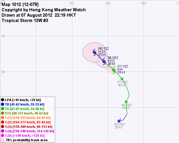
13W continues to move north. At 14 HKT, 13W was centred about 900 km (490 NM) NNW of Wake Island.

13W 繼續北移。在下午 2 時,13W 集結在威克島西北偏北約 900 公里 (490 海里)。

TC Naming 氣旋命名

N/A 不適用

Movement Analysis 路徑分析

The ridge to the west of 13W has weakened. As 13W travels north, the subtropical ridge northeast of the storm will assume steering influence and 13W will turn NW.

13W 西面的脊場已經減弱。隨著 13W 北移,它將受東北面的副熱帶高壓脊影響而逐漸轉為向西北移動。

Intensity Analysis 強度分析

Current T-number: T2.5/2.5/D0.5/24 HRS
13W is expected to maintain strength initially but weaken gradually later, as sea temperature continues to drop.

現時的 T 號碼: T2.5/2.5/D0.5/24 HRS
預料 13W 將於初期維持強度,其後受較冷海水影響而逐漸減弱。

Effects on Hong Kong 對香港的影響

No threat to Hong Kong is expected within the next 72 hours.

13W 於未來的 72 小時將不會對香港構成任何影響。

Next Update 下次更新

2012/08/07 (Tue 二), night 晚間 (or earlier 或更早)

Other Images 其他圖像
JTWC Track 聯合颱風警報中心路徑圖
JMA Track 日本氣象廳路徑圖
HKO Satellite 香港天文台衛星圖
HKO Track 香港天文台路徑圖
Probabilities of TC Signals from HKO 香港天文台 (已) 發出 / 取消熱帶氣旋警告信號的機率
N/A 不適用

+13W Bulletin 發佈 #1 (2012/08/05, 16:00 HKT)

Name of System 系統名稱

TD 13W 熱帶低氣壓 13W


JTWC No. / Int'l No. JTWC 編號 / 國際編號 13W / ----
Bulletin Number 發佈編號 #1
Time of Report 報告時間

2012/08/05, 16:00 HKT (08:00 UTC)

Time of Observation 觀測時間 2012/08/05, 14:00 HKT (06:00 UTC)
Position 位置 23.3°N, 162.2°E
Maximum Gust 最高陣風 40 knots 節 (75 km/h 公里每小時)
1-min. Average Wind Speed 1分鐘平均風速 30 knots 節 (55 km/h 公里每小時)
10-min. Average Wind Speed 10分鐘平均風速 25 knots 節 (45 km/h 公里每小時)
Pressure 氣壓 1004 hPa 百帕斯卡
Past 6-hr Movement 過去6小時移向和移速 ENE 東北偏東 (070°) at 6 knots 節 (11 km/h 公里每小時)
Area(s) affected 受影響地區 N/A 不適用

Forecast Track 預測路徑圖

Forecast Positions 預測位置資料

Tau
時間差
HK Time
香港時間
Lat.
緯度
Long.
經度
Movement
移動速度和方向
1-min Average Strength
一分鐘平均強度
t+0 08/05 (Sun) 14:00 23.3°N 162.2°E NNE 東北偏北 (024°) 10 km/h 30 kt (56 km/h) TD 熱帶低氣壓
t+12 08/06 (Mon) 02:00 24.3°N 162.7°E N 北 (007°) 14 km/h 35 kt (65 km/h) TS 熱帶風暴
t+24 08/06 (Mon) 14:00 25.8°N 162.9°E N 北 (003°) 15 km/h 35 kt (65 km/h) TS 熱帶風暴
t+36 08/07 (Tue) 02:00 27.4°N 163.0°E N 北 (354°) 15 km/h 40 kt (74 km/h) TS 熱帶風暴
t+48 08/07 (Tue) 14:00 29.0°N 162.8°E NW 西北 (324°) 13 km/h 40 kt (74 km/h) TS 熱帶風暴
t+72 08/08 (Wed) 14:00 31.2°N 160.9°E N/A 40 kt (74 km/h) TS 熱帶風暴

Overview 總覽

Tropical disturbance 90W was upgraded to depression 13W earlier today. At 14 HKT, 13W was centred about 640 km (350 NM) NW of Wake Island.

熱帶擾動 90W 今天較早時被升格為熱帶低氣壓 13W。在下午 2 時,13W 集結在威克島西北約 640 公里 (350 海里)。

TC Naming 氣旋命名

N/A 不適用

Movement Analysis 路徑分析

13W is moving irregularly as it is steered by the ridges to its west, southeast and northeast. The western ridge is expected to weaken, and the eastern ridges will gradually drive the storm north. The northeastern ridge may strengthen later so that 13W's track should become more equatorward by t+72.

受到西面、東南面和東北面脊場的影響,13W 現時移動路徑較不規則。預料西面脊場將減弱,從而令 13W 受東面高壓脊帶動而往北移。預報模式顯示 13W 東北面的高壓或於預測期後段增強,令 13W 路徑於 72 小時後較為偏西。

Intensity Analysis 強度分析

Current T-number: T2.0/2.0/INT OBS
Sea temperatures are marginal for storm development. As 13W travels north seas will get even cooler, and should not be favourable for 13W to intensify.

現時的 T 號碼: T2.0/2.0/INT OBS
13W 附近海溫尚可,但隨著它北移海溫將進一步降低,這將會令 13W 的發展受限制。

Effects on Hong Kong 對香港的影響

No threat to Hong Kong is expected within the next 72 hours.

13W 於未來的 72 小時將不會對香港構成任何影響。

Next Update 下次更新

2012/08/06 (Mon 一), night 晚間 (or earlier 或更早)

Other Images 其他圖像
JTWC Track 聯合颱風警報中心路徑圖
JMA Track 日本氣象廳路徑圖
HKO Satellite 香港天文台衛星圖
HKO Track 香港天文台路徑圖
Probabilities of TC Signals from HKO 香港天文台 (已) 發出 / 取消熱帶氣旋警告信號的機率
N/A 不適用

Track Data from HKWW 本站之路徑資料

YYMMDDZZ Lat Long Wind
12080418 235N1618E 025
12080500 231N1616E 030
12080506 233N1622E 030
12080512 241N1627E 035
12080518 251N1626E 035
12080600 258N1626E 035
12080606 267N1630E 035
12080612 275N1628E 035
12080618 286N1623E 040
12080700 290N1620E 040
12080706 298N1613E 040
12080712 302N1609E 035
12080718 305N1604E 035
12080800 314N1595E 040
12080806 320N1584E 040
12080812 327N1572E 040
12080818 334N1566E 040
12080900 343N1554E 045
12080906 360N1541E 050
12080912 373N1528E 045
12080918 392N1518E 045
12081000 416N1497E 045
12081006 442N1481E 040