
TC Watch / 熱帶氣旋 > Selected TC Review / 重要熱帶氣旋回顧 > 201209W (VICENTE 韋森特) [Refresh 更新]
 201209W (VICENTE 韋森特) - Profile 檔案 201209W (VICENTE 韋森特) - Profile 檔案 |
(First draft issued on August 11, 2012; final version issued on December 25, 2012)
(初稿於 2012 年 8 月 11 日發出,最後版本於 12 月 25 日上載)
Brief profile of VICENTE 韋森特小檔案:
| JTWC number 聯合颱風警報中心 (JTWC) 號碼 | 09W |
| International number 國際編號 | 1208 |
| Period of existence 生存時期 (JTWC) | 2012/07/21 02 HKT - 2012/07/24 08 HKT* |
| Lifetime 壽命 (JTWC) | 3.25 days 日* |
| Maximum 1-minute wind (JTWC) JTWC 一分鐘平均最高中心風速 | 115 knots 節 (Category 4 Typhoon 四級颱風) |
| Minimum pressure (JTWC) JTWC 最低氣壓 | 937 hPa 百帕 |
| Highest TC signal by HKO (if applicable) 香港天文台發出最高熱帶氣旋警告信號 |
10 (Hurricane Signal 颶風信號) |
| Closest point of approach by HKO (if applicable) 香港天文台所示之最接近距離 (如適用) |
SW 100 km (real-time warning 實時報告 / TC report 熱帶氣旋報告) |
| Time of closest approach by HKO (if applicable) 香港天文台所示之最接近時間 (如適用) |
Around 約 2012/07/24 01 HKT (real-time warning 實時報告) / 01-02 HKT (TC report 熱帶氣旋報告) |
| Lowest pressure recorded at HKO (if applicable) 香港天文台錄得的最低氣壓 (如適用) |
986.0 hPa 百帕 (2012/07/24 00:53 HKT) |
*The JTWC issued final bulletin once VICENTE made landfall before its dissipation. 聯合颱風警報中心於韋森特登陸後不久發出最後警報,當時韋森特還未完全消散。
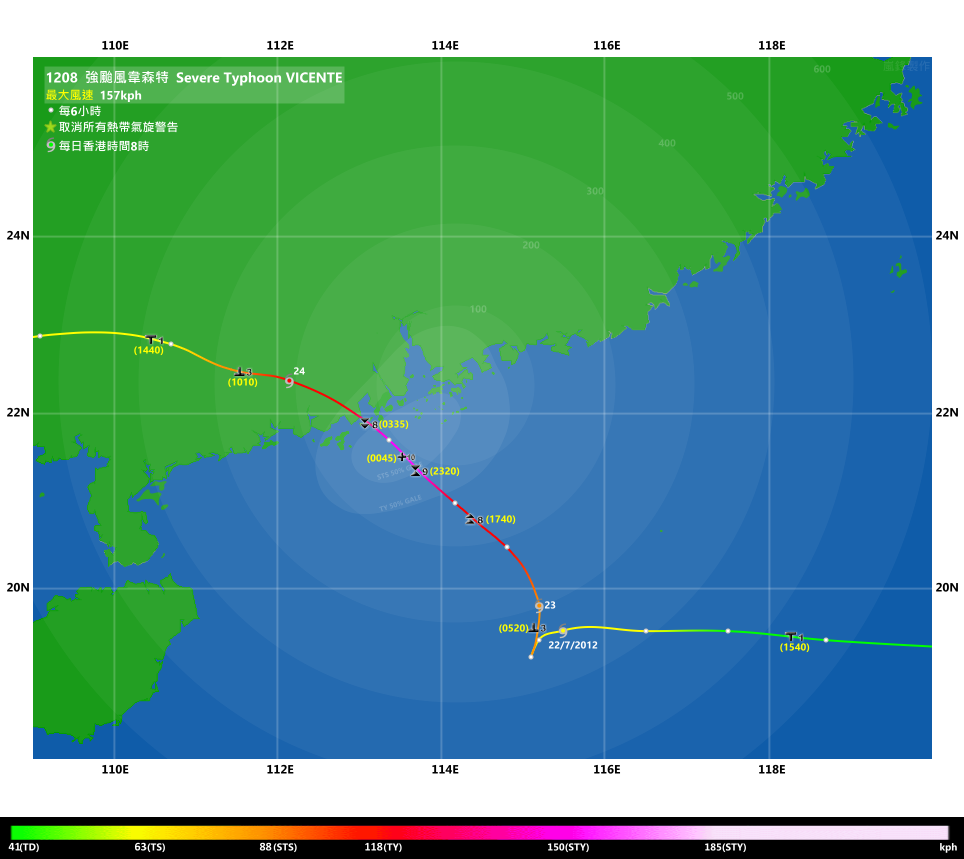
TC signals for Hong Kong & Track 香港曾經生效的熱帶氣旋警告和路徑圖:
Table 表:
| Signal 信號 |
Date and time 日期和時間 |
Distance from HK 與香港的距離 |
Predicted movement 預測移動方向和速度 |
Max. 10-min winds 中心最高十分鐘平均風速 |
 |
2012/07/21 (SAT) 15:40 HKT | SE 550 km | WNW at 18 km/h | 55 km/h (30 knots, TD) |
 |
2012/07/23 (MON) 05:20 HKT | SSE 330 km | N slowly at first | 90 km/h (50 knots, STS) |
 |
2012/07/23 (MON) 17:40 HKT | S 170 km | WNW at 20 km/h | 120 km/h (65 knots, CAT. 1 / TY) |
 |
2012/07/23 (MON) 23:20 HKT | SSW 130 km | NW/WNW at 20 km/h | 130 km/h (70 knots, CAT. 1 / TY) |
 |
2012/07/24 (TUE) 00:45 HKT | SW 100 km | NW at 20 km/h → WNW | 155 km/h (85 knots, CAT. 2 / ST) |
 |
2012/07/24 (TUE) 03:35 HKT | WSW 120 km | NW at 20 km/h → WNW | 155 km/h (85 knots, CAT. 2 / ST) |
|
2012/07/24 (TUE) 10:10 HKT | W 230 km | WNW at 22 km/h | 110 km/h (60 knots, STS) |
|
2012/07/24 (TUE) 14:40 HKT | W 380 km | W at 22 km/h | 85 km/h (45 knots, TS) |
 |
2012/07/24 (TUE) 23:15 HKT^ | W 600 km | W/WSW at 25 km/h | 65 km/h (35 knots, TS) |
^The Strong Monsoon Signal was issued one minute after the cancellation of the Standby Signal.
^強烈季候風信號於一號戒備信號取消後一分鐘發出。
Figure 圖:
(Track courtesy of Lorenzo. Data from HKO. 鳴謝 Lorenzo 提供路徑圖,資料取自天文台)
Percentile Ranks 百分等級:
Note: Since only two tropical cyclones necessitated the #10 Hurricane Signal since 1986, the following percentile ranks are obtained taking all tropical cyclones necessitating at least the #3 Strong Wind Signal into account.
注意:由於 1986 年起只有兩個熱帶氣旋令天文台發出十號颶風信號,下列百分等級是對應期間所有令天文台發出三號或更高信號之熱帶氣旋帶來的風力。
Percentile rank among all storms necessitating at least the #3 Strong Wind Signal from 1986 to 2012 (at compilation of this review)*: *This measures the relative wind strength in Hong Kong caused by this storm compared with others. 指標顯示此風暴相對於其他氣旋為香港帶來之風力強度 For more information, please refer to Wind Speed Data for TCs that Have Affected Hong Kong. 更多資訊載於 影響香港氣旋之風速數據 頁 |
Overall: 總計: |
|
Strong 強 |
|||
| Component Ranks 分部等級 | ||||||
| Reference stations: 參考站: |
|
Strong 強 |
||||
| Victoria Harbour: 維多利亞港: |
|
Strongest 最強 |
||||
| Urban: 市區: |
|
Strong 強 |
||||
| Offshore & high ground 離岸和高地: |
|
Strong 強 |
||||
Cyclones that attained similar rating: YORK (1999) 相近級別之熱帶氣旋:約克 (1999) |
||||||
IR imagery animation 紅外線雲圖動畫:
TC track from HKWW 本站的熱帶氣旋路徑圖:
TC track from HKO 天文台的熱帶氣旋路徑圖:
| Past HKWW Bulletins on VICENTE 本站有關韋森特的發佈 |
Please click here for bulletins on VICENTE. 請按這裡。
| Storm Formation and Development 氣旋形成和發展 |
Unless otherwise stated, all times below are in Hong Kong Standard Time (UTC+8)
除非特別註明,下文時間均為香港標準時間 (協調世界時加 8 小時)
VICENTE necessitated the first No. 10 Hurricane Signal since typhoon YORK in 1999. It is also the first such signal issued in July since 1946. The storm developed off the tail of convections left by tropical cyclone KHANUN that recurved towards the Korean Peninsula in mid-July. The patch of convections drifted southwards towards the seas east of the Philippines, where the system gradually picked up strength. The HKO upgraded the low pressure area into a tropical depression at 13 HKT on July 20, while the JTWC issued the tropical cyclone formation alert 1 hour later. The spread among different model predictions was wide; although the subtropical ridge northeast of the storm means a general WNW movement, the mainstream prediction shifted west gradually from forecasting landfall at Taiwan to Leizhou Peninsula in two days, responding to the storm's rapid westward movement. There were some outliers that predicted an abrupt northward turn, which turned out to be true.
Initial intensity estimation was modest as conditions were moderately favourable for development, but the storm was not expected to remain long at sea. Indeed the storm's convections were constantly being sheared to the west like DOKSURI that approached the territory in June, and the situation did not improve after the storm skirted northern Luzon and entered South China Sea. The JTWC upgraded the system into tropical depression 09W at 02 HKT on July 21 when it was crossing northern Luzon.
韋森特是自 1999 年颱風約克以來第一個令天文台發出十號颶風信號的熱帶氣旋。此十號信號亦是自 1946 年來首次於 7 月發出。韋森特從 7 月中旬轉向趨向朝鮮半島的熱帶氣旋卡努留下的對流雲團發展起來。該團對流向南飄移至菲律賓以東海域,並逐漸增強。天文台於 7 月 20 日下午 1 時升格該低壓區為熱帶低氣壓,而聯合颱風警報中心 (JTWC) 則於一小時後發佈熱帶氣旋形成警報。各數值預報模式預測的分歧頗大;雖然副熱帶高壓脊處於風暴東北面意味著向西北偏西移的整體路徑,但隨著該熱帶低氣壓快速向偏西移動,預測於兩日內從吹襲台灣西調至雷州半島。當時部分模式預測風暴會突然轉北,結果「爆冷」實現。
縱使大氣環境整體上支持風暴發展,但由於預測該系統不會於海上停留太久,該氣旋形成初期的強度預測較為保守。實際上,這個熱帶低氣壓的對流明顯向西切離,就如 6 月吹襲本港的氣旋杜蘇芮那樣,情況於該熱帶低氣壓掠過呂宋北部進入南海以後仍未見好轉。JTWC 於 21 日凌晨 2 時,即氣旋經過呂宋北部時升格該系統為熱帶低氣壓 09W。

Figure 1 - Satellite image of VICENTE at formation
圖 1 - 韋森特形成時的衛星圖片

Figure 2 - Initial forecast track issued by the HKO
圖 2 - 天文台首個預測路徑
| Entering South China Sea and Stagnation 進入南海並滯留 |
09W slowed down a bit and consolidated in the second half of July 21. Its spiraling feature became more prominent, although the northeastern half was still devoid of deep convections. The No. 1 Standby Signal was issued at 15:40 HKT when 09W was 550 km SE of the territory. Influenced by the subsidence of 09W, southern China experienced a very hot afternoon. In Hong Kong, almost all stations reached 33 degrees and a maximum temperature of 37.6 degrees was recorded at Sheung Shui, followed by 37.1 degrees at Happy Valley. The extreme hot weather induced convective activities and intense thunderstorms were detected in the afternoon. The convective patch approached from the northeast and arrived at Hong Kong at around 17:20 HKT. The HKO issued the Amber Rainstorm Warning at 17:35 HKT to warn the public. Nevertheless the rainfall was short-lived as the rain-bearing clouds moved southwest rapidly, missing western Hong Kong altogether. The Amber Rainstorm Warning was cancelled at 18:40 HKT.
09W showed signs of intensification and the JMA upgraded it into a tropical storm at 20 HKT. The name given to 09W is VICENTE, which was contributed by the United States and is a Chamorro male name. Various agencies were putting VICENTE's landfall position near Leizhou Peninsula, so that the storm would just miss the 200-km boundary. The subtropical ridge steering VICENTE was weakened heavily by the arriving troughs in central and northern China. That same series of troughs was responsible for the record-breaking rainfall in Beijing which killed at least 77. In response, VICENTE decelerated further on July 22 and stopped moving altogether in the afternoon. The storm stopped losing longitude and dipped southwards slightly towards the evening. According to HKO's storm locations in its live bulletins, VICENTE only moved 10 km from 14 to 21 HKT. This slow movement provided time for VICENTE to absorb energy. The HKO also delayed the time for considering higher signals, from "later today" in the bulletins issued at early July 22 to "when VICENTE starts to take on a steady track towards the South China coast or local winds strengthen significantly" in the afternoon, showing the uncertainty in future storm movement. Apart from a few showers, the weather was generally stable throughout July 22. Wind direction at some stations backed from the east to northeast during the day.
09W 於 7 月 21 日稍為減慢且逐漸整合,其旋捲性漸趨明顯,但東北部仍然缺乏深層對流。天文台於下午 3 時 40 分發出一號戒備信號,當時 09W 在本港東南約 550 公里處。受 09W 的下沉氣流影響,華南當天下午天氣酷熱。在本港,幾乎所有氣象站錄得高於 33 度,上水和跑馬地的高溫更分別達 37.6 及 37.1 度。酷熱天氣令對流活動變得活躍,猛烈雷暴於下午發展。積雨雲從東北面飄來,在下午 5 時 20 分左右到達香港。天文台於下午 5 時 35 分發出黃色暴雨警告信號以作警示,但雷雨持續時間不長,雲雨帶快速向西南移動,完全避開香港西部。黃色暴雨警告信號遂於下午 6 時 40 分取消。
09W 當晚有跡象增強,日本氣象廳於晚上 8 時升格 09W 為熱帶風暴,並將其命名為韋森特。此名字由美國提供,為一查摩洛男性名字。各官方機構預測韋森特於雷州半島一帶登陸,風暴將於本港 200 公里以外不遠處掠過。帶領韋森特的副熱帶高壓脊受中國中北部連串西風槽侵襲而大幅減弱;該西風槽令北京錄得破紀錄雨量,導致最少 77 人死亡。副高減弱令韋森特於 22 日進一步減慢,中午開始更停滯不前。韋森特停止西移,於傍晚稍為南移。按照天文台熱帶氣旋警報中的氣旋位置,韋森特於當天下午 2 至 9 時只移動 10 公里。慢速移動令韋森特有充足時間在海面上吸收能量。天文台亦因為韋森特移動緩慢而推遲考慮更高信號的時間,由 22 日早段發佈所表示之「今日稍後」改為下午發佈的「當韋森特開始穩定移向華南沿岸或本港風力顯著增強時」,顯示其路徑的不確定性。除一兩陣驟雨外,22 日天氣大致穩定,當天部分地方風向由偏東逆轉至東北。

Figure 3 - Maximum air temperature on July 21
圖 3 - 7 月 21 日本港各地最高氣溫

Figure 4 - Intense thunderstorms approached eastern Hong Kong on July 21
圖 4 - 猛烈雷暴於 7 月 21 日靠近香港東部

Figure 5 - Distribution of local lightning strokes
圖 5 - 本地閃電分布圖

Figure 6 - Satellite image of VICENTE when it was upgraded into a tropical storm by the JMA
圖 6 - 日本氣象廳升格韋森特為熱帶風暴時的衛星雲圖

Figure 7 - Steering flow chart at 14 HKT, July 22
圖 7 - 7 月 22 日下午 2 時之駛流圖

Figure 8 - Vertical wind shear chart at 14 HKT, July 22
圖 8 - 7 月 22 日下午 2 時之垂直風切變分布圖

Figure 9 - Wind field analysis at 09:43 HKT, July 22
圖 9 - 7 月 22 日上午 9 時 43 分之風場分析圖
| Northward Turn 轉向北移 |
After some southward movement, VICENTE stopped again and turned north near midnight, July 23. Convections in the eastern semicircle had improved, but the spiraling bands became disorganized in the northern periphery. The void, however, was quickly filled as VICENTE intensified into a severe tropical storm near dawn. As VICENTE started moving and could be edging closer to Hong Kong than expected, the HKO issued the No. 3 Strong Wind Signal at 05:20 HKT when the storm was 330 km SSE of Hong Kong. The HKO was very careful in its wordings, saying that higher signals would not be likely during daytime unless VICENTE's speed increased.
Forecast tracks were adjusted northwards again as it was clear that the subtropical ridge had retreated. VICENTE continued to intensify in the morning. Shortly after noon, VICENTE passed in the vicinity of an oil platform operated by China National Offshore Oil Corporation. The platform registered a minimum station pressure of 960.3 hPa. By comparing pressures, the barometer was estimated to be around 50 metres from sea level, so that the equivalent sea level pressure was around 966 hPa. This and the 10-minute sustained wind measurement of 126 km/h when the eyewall swept across that platform are definitive evidence that VICENTE had reached typhoon strength. As described in a later media report, the HKO again collaborated with the Government Flying Service to send a plane into VICENTE for collecting wind and pressure data near noon on July 23. At that time a strength of 75 knots (139 km/h) was detected, although the report did not specify the exact height where the measurement was made. The Observatory eventually upgraded VICENTE into a typhoon at 14 HKT, adding that the No. 8 Signal would be considered between 17 and 20 HKT.
Some westward track component set in near noon, but VICENTE had been maintaining a general NW track that would bring the storm to within 150 km of Hong Kong. Locally, northeasterly winds picked up slightly in the early afternoon, while rain had become more persistent. Winds surged suddenly after 15:30 HKT following the arrival of another rainband. By 16 HKT, gale force winds were recorded at stations like Waglan Island, Cheung Chau and Green Island, whereas strong winds were recorded at some other stations including Tai Mei Tuk, Sha Chau and Sai Kung. The HKO issued the Pre-No. 8 Special Announcement at 15:45 HKT which indicated the No. 8 Signal would be issued by 18 HKT the latest. Cargo handling services were suspended at 16 HKT, and ferry companies announced service suspensions from dusk; in particular, the Star Ferry service between Tsim Sha Tsui and Central/Wan Chai would be suspended from 19 HKT, while jetfoil services between Hong Kong and Macau would be terminated at 17 or 18 HKT.
At that time, the annual Book Fair was being held at the Hong Kong Convention and Exhibition Centre. Following the HKO's prediction of higher signals, the organizer announced that the venue would be closed at 17:45 HKT. Loads of commuters hurried back home and caused increased burden on public transport.
稍為南移後,韋森特於 7 月 23 日約午夜時份再度停留並改向北移。韋森特東面的對流有所改善,但北面的螺旋雲帶較為鬆散。雖然如此,該空位迅速被填滿,韋森特於日出前增強為強烈熱帶風暴。由於韋森特已明顯開始移動且可能比預期更為靠近香港,天文台於上午 5 時 20 分發出三號強風信號,韋森特當時於本港東南偏南約 330 公里。天文台用字審慎,表示除非韋森特速度加快,否則日間發出八號信號的機會不大。
各台預測路徑因應副熱帶高壓脊減弱東退而逐步北調。韋森特於 23 日早上繼續增強,於中午過後掠過中國海洋石油於南海的一個油台,錄得最低氣壓 960.3 百帕。經氣壓比對,油台上氣壓計估計離海面約 50 米,得出當時海平面氣壓約為 966 百帕。該油台於韋森特眼牆掠過時曾錄得最高 10 分鐘持續風速達每小時 126 公里,此兩項數據皆證明韋森特已達颱風強度。由事後媒體報導得知,當天接近正午時份天文台聯同政府飛行服務隊派遣飛機到達風暴中心附近搜集風速和氣壓等資料,當時錄得風速為 75 節 (每小時 139 公里),但高度未有明確表示。天文台最終於下午 2 時升格韋森特為颱風,並表示將於下午 5 至 8 時考慮改發八號信號。
韋森特路徑中午過後出現偏西分量,但風暴大致向西北移動,按此路徑將進入本港 150 公里範圍。香港下午初段東北風開始增強,降雨亦變得較為持續。一道雨帶於下午約 3 時 30 分靠近,風速順勢上升。至下午 4 時,部分地方如橫瀾島、長洲及青洲開始吹烈風,而大美督、沙洲及西貢等則吹強風。天文台於下午 3 時 45 分發出預警八號熱帶氣旋警告信號之特別報告,表示將於下午 6 時或之前發出八號信號。貨櫃交收服務於下午 4 時暫停,而各渡輪公司宣布服務將於下午較後至日落時份開始暫停,其中天星小輪尖沙嘴至中環及灣仔航線於晚上 7 時暫停服務,而連接香港及澳門的噴射飛航則於下午 5 至 6 時停航。
至於當時於會展舉行的書展,主辦機構宣布場館將於下午 5 時 45 分關閉。本港各處都是希望盡快趕回家的下班人士,為公共交通增添很大負擔。


Figures 10a and 10b - Forecast tracks from various official agencies on July 22 and July 23
圖 10a 及 10b - 7 月 22 及 23 日各官方台預測路徑
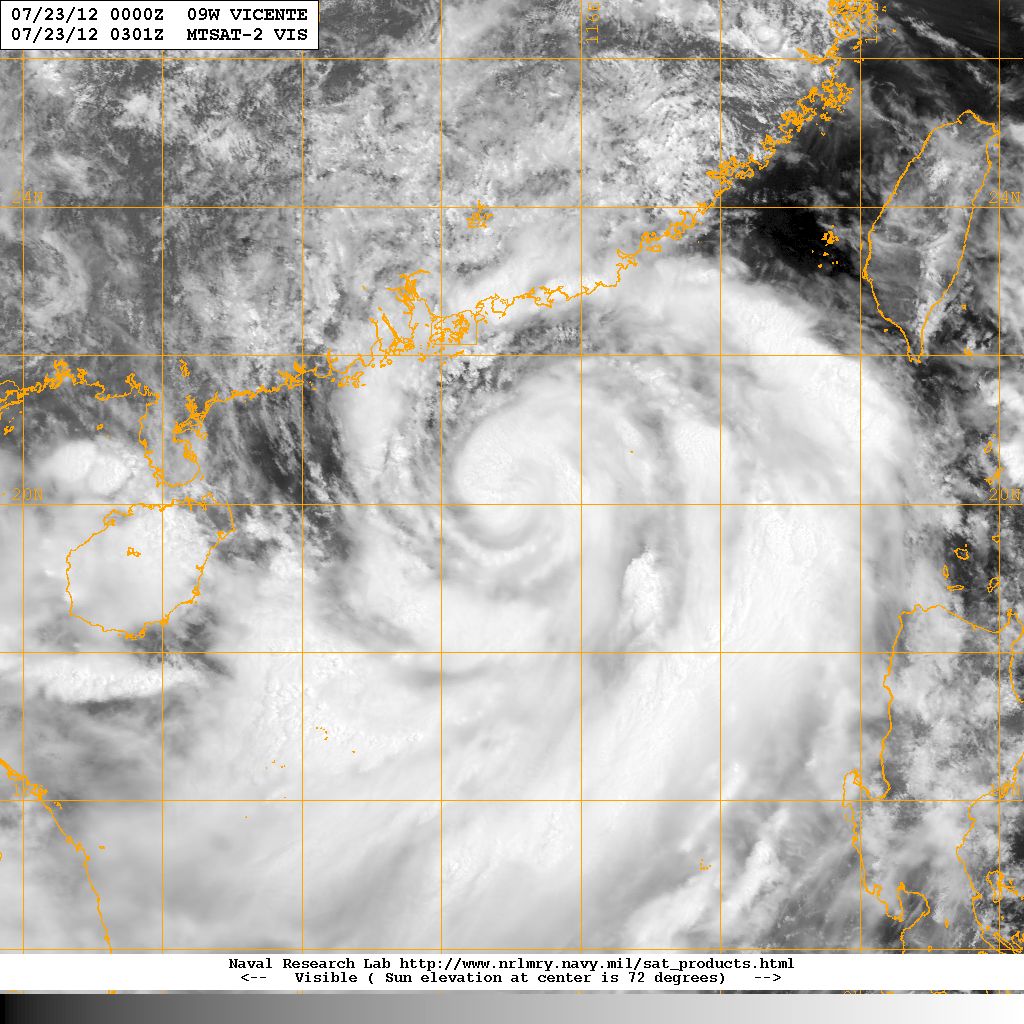
Figure 11 - Visible satellite image of VICENTE on July 23. VICENTE was intensifying into a typhoon at that time.
圖 11 - 7 月 23 日之可見光衛星雲圖,當時韋森特正增強為一颱風

Figure 12 - Pressure (hPa), wind speed (km/h) and wind direction (true bearing) recorded at the oil platform on July 23. Sea level pressure is calculated assuming a height of 50 metres.
圖 12 - 油台於 7 月 23 日錄得的氣壓 (百帕)、風速 (公里每小時) 及風向 (真方位角) 數據。海平面氣壓估算假設油台離海面 50 米高
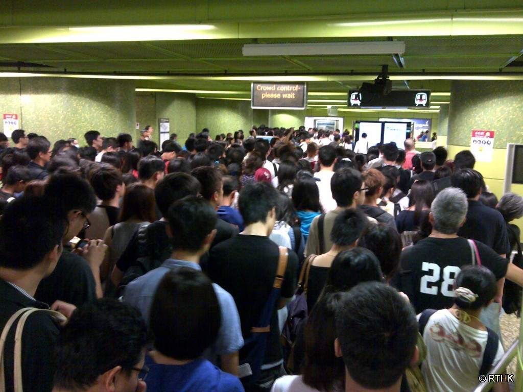
Figure 13 - Commuters rushing home after the Pre-No. 8 announcement. Photo credit: RTHK
圖 13 - 八號信號預警發出後下班人士趕回家的情況。圖片來源:香港電台
| Rapid Intensification and Approaching HK 急速增強並靠近香港 |
On radar and satellite images, VICENTE's appearance looked better hour after hour. As it travelled north, it entered a region of even less vertical wind shear while sea temperatures remained high. In the South China Coastal Waters weather bulletin issued at 16:30 HKT on July 23, the Observatory mentioned that force 12 winds would be observed in southern areas within Hong Kong adjacent seas. The No. 8 Northeast Gale or Storm Signal was issued at 17:40 HKT, with VICENTE just 170 km south of Hong Kong and still moving in a northwesterly direction. The westward turn that most agencies had predicted was happening at a much gradual pace. Probably because of the greater distance between the storm and Macau, the enclave did not see the No. 8 Signal hoisted until 19 HKT.
Two hours after the issuance of the No. 8 Signal, bus services were also reduced, and only MTR remained regular service. Except for special routes, all bus services were terminated at 20:40 HKT. Winds were still strengthening from the northeast and another major increment was observed near 20 to 21 HKT, when wind speeds at a number of stations surged by 20 km/h or more. By 21:30 HKT, stations like Waglan Island, Tate's Cairn, Green Island, Cheung Chau had recorded storm force winds; Sai Kung was blowing gale force winds and some other urban stations observed strong force winds.
VICENTE's eye became clearer during the first half of the night of July 23, becoming increasingly easier to discern on infrared satellite images. Various agencies were putting VICENTE's strength as a minimal typhoon (65 to 70 knots) in their 20 HKT intensity estimations. Although the storm had reached Hong Kong's longitude, it was still approaching the territory due to its northwestward movement. This means that winds would very likely continue to strengthen, and this prompted the Observatory to mention that higher signals may be needed in its 21 HKT bulletin.
Although the rain was persistent, the intensity was not very high. Nevertheless the Observatory warned that flooding may occur at low-lying areas at high tide near 02 HKT on July 24 due to the storm surge created by VICENTE. The strong winds had also compromised electricity system, as intermittent disruptions were detected.
A significant number of trees were uprooted by VICENTE's fierce winds. Winds surged suddenly between 22 HKT and 23 HKT; in addition to the above stations, storm force winds were also observed at Peng Chau and Tai Mei Tuk. Winds at Ngong Ping had already gone up to hurricane force and even stations that are relatively insensitive like Ta Kwu Ling, King's Park and Sha Tin started to observe strong force winds. Wind direction started to change from northeast to east, especially at eastern Hong Kong. The Observatory issued the No. 9 Increasing Gale or Storm Signal at 23:20 HKT to signal such deterioration. VICENTE was approaching the 100-km radius at that time. Some agencies were also revising VICENTE's central wind speed upwards in response to the clear eye that popped out in satellite images. The HKO first revised its estimated wind speed from 120 km/h to 130 km/h at 21 HKT, and then upgraded it to a severe typhoon with sustained winds of up to 155 km/h at midnight of July 24. The revision made by the JTWC was even more dramatic --- the agency amended its 20 HKT bulletin near 01 HKT, upgrading the storm from a 70-knot (130 km/h) category 1 typhoon to a 120-knot (222 km/h) category 4 typhoon. Satellite fix bulletin also indicated a huge jump in the associated T-number to T6.5 due to its excellent eyewall structure. A NASA article later explained that the presence of hot towers evident from satellite images was hinting at such rapid intensification.
從雷達和衛星雲圖可見,韋森特的外貌一小時比一小時完整。隨著韋森特北移,它進入風切較低的區域,而海溫仍然較高。在 7 月 23 日下午 4 時 30 分發出的華南海域天氣報告中,天文台預計香港鄰近海域南部將吹 12 級颶風。天文台在下午 5 時 40 分發出八號東北烈風或暴風信號,韋森特當時於香港以南 170 公里,並向西北移動。各台先前預計的西轉幅度比實際大。可能由於韋森特與澳門的距離較遠,當地於下午 7 時才懸掛八號風球。
八號信號發出兩小時後,巴士服務開始減少,只有港鐵維持正常服務。除特別路線外,所有巴士路線於晚上 8 時 40 分暫停服務。本地東北風進一步增強,風力於晚上 8 至 9 時急增,部分風速站錄得超過每小時 20 公里的上升。至晚上 9 時 30 分,橫瀾島、大老山、青洲、長洲均曾錄得持續暴風,西貢等吹烈風而一些市區站亦吹強風。
韋森特的風眼於 23 日晚間前半部漸趨明顯,於紅外線衛星雲圖上清晰可見。大部分官方預測台於晚上 8 時估算韋森特的風力約為 65 至 70 節,即颱風下限強度。雖然韋森特已到達香港的經度,但由於它向西北移動,它其實仍然正在靠近本港,這暗示風勢很可能會進一步增強,因而天文台於晚上 9 時的熱帶氣旋警報中指出可能要考慮更高熱帶氣旋警告信號。
雖然降雨連綿不斷,但雨勢不強。天文台警告低窪地區可能於翌日凌晨 2 時潮漲時因風暴潮出現海水倒灌引起水浸。強風亦令供電出現問題,晚間曾多次出現電壓驟降。
韋森特的狂風令不少樹木倒塌。風力於晚上 10 至 11 時突然急速上升。除上述地方外,坪洲及大美督亦開始錄得暴風,而昂坪則已錄得颶風。部分較不當風的地方如打鼓嶺、京士柏及沙田也吹起強風。風向逐漸由東北順轉至偏東,特別是香港東部地區。因應風勢增強,天文台於晚上 11 時 20 分改發九號烈風或暴風增強信號,韋森特正逐漸靠近本港 100 公里範圍。隨著清晰風眼於衛星圖上出現,部分官方機構上調韋森特的中心風力。天文台首先於晚上 9 時將風力由每小時 120 公里上升至 130 公里,繼而在 24 日午夜升格韋森特為強颱風,風力為每小時 155 公里。JTWC 更於凌晨 1 時由原先晚上 8 時發佈的 70 節 (每小時 130 公里、一級颱風) 一下子修訂至 120 節 (每小時 222 公里) 的四級颱風強度,而定位發佈中的 T 指數亦因眼牆結構極佳而急升至 T6.5。美國太空總署其後一篇文章指出,韋森特當時發展出熱塔,為氣旋急速增強的徵兆。


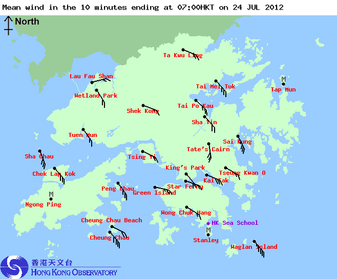
Figures 14a to 14f - Wind directions and speeds across Hong Kong at 16, 19 and 22 HKT of July 23, and 01, 04 and 07 HKT of July 24
圖 14a 至 14f - 7 月 23 日下午 4 、7 和 10 時,以及 24 日上午 1 、4 和 7 時之風向和風速分布圖

Figure 15 - JTWC's amendment to its bulletin at 20 HKT, July 23
圖 15 - JTWC 修訂 7 月 23 日晚上 8 時的發佈

Figure 16 - Wind field analysis at 22:10 HKT, July 23. Storm force winds were affecting Hong Kong
圖 16 - 7 月 23 日晚上 10 時 10 分之風場分析圖,暴風正影響香港


Figures 17a and 17b - Satellite images of VICENTE at 22:40 HKT on July 23 (left) and 01:32 HKT on July 24 (right), clearly showing VICENTE's well-defined eye
圖 17a 及 17b - 韋森特於 7 月 23 日晚上 10 時 40 分 (左) 及 24 日凌晨 1 時 32 分 (右) 的衛星雲圖,其完整風眼清晰可見
| The Number 10 Hurricane Signal 十號颶風信號 |
Shortly after the No. 9 Signal was issued, MTR train services involving open tracks were gradually suspended. Following a break of power cable by a falling tree near Tai Po Market in the East Rail Line, passengers were immediately stranded. The ensuing handling of the matter and MTR's failure to provide shuttle buses for passengers stranded at various stations sparked controversy, but the rebuttal that providing road transport at such adverse conditions was much more dangerous seems justified.
VICENTE's rainbands continued to strike Hong Kong, but its innermost eyewall was never close enough to touch the territory. Still winds continued to strengthen after midnight, with sustained winds at Cheung Chau touching hurricane force for the first time at around 00:10 HKT on July 24. Around that time, a few lightning strokes were detected and flashes could even be seen in the sky. The Thunderstorm Warning was issued at 00:15 HKT. Such thunderstorm activity is believed to be associated with the violent convective activity near the centre of the cyclone.
The historic moment arrived at 00:45 when the No. 10 Hurricane Signal was issued. This is the first Hurricane Signal issued in 13 years, and it would turn out that VICENTE broke the record for the most distant storm necessitating the ultimate signal, the previous record being 70 km during the approach of an unnamed typhoon in 1946. At that time, sustained winds at Cheung Chau were fluctuating close to the margin of hurricane force winds (118 km/h) while that of Cheung Chau Beach, a station close to the Cheung Chau main station but is more sensitive to northeasterly winds and at a much lower altitude, were above the threshold for around half an hour in the past 60 minutes. Thus it is believed that the situation at Cheung Chau was a deciding factor in the issuance of the No. 10 Signal, possibly together with some other undisclosed data obtained from certain stations in southwestern Hong Kong. In the next tropical cyclone bulletin issued at 01 HKT, the Observatory warned that VICENTE, at around 100 km from the Headquarters, would be closest to Hong Kong in the next few hours. Southwestern Hong Kong, which is very close to VICENTE's eyewall, would be under the impact of hurricane force winds.
At most unobscured stations, winds were the strongest between midnight and 02 HKT, generally coming in from the east. However, apart from Cheung Chau, none of the disclosed near-sea-level stations managed to record hurricane force winds; even Waglan Island, a station known to be unobscured in the eastern semicircle, fell short of the threshold by 5 km/h. This showed that VICENTE's hurricane force wind radius was not wide enough to cover the whole of southern Hong Kong. Normally very obscured stations like Tsing Yi and Wetland Park also managed to register strong force winds; this is the first time since Typhoon Hagupit in 2008 that all 8 reference stations experienced sustained strong force winds during the passage of a tropical cyclone. The incessant rain also prompted the Observatory to issue the Landslip Warning at 01:10 HKT, and the Amber Rainstorm Warning as well as the Special Announcement on Flooding in the Northern New Territories (Special Announcement) at 01:55 HKT. The Amber Rainstorm Warning and the Special Announcement were effective until 10:40 HKT and 12:25 HKT respectively, while the Landslip Warning remained in force until 15 HKT. According to the Observatory's Tropical Cyclone Warning for Shipping issued for 02 HKT, the hurricane, storm and gale radii of the storm were 45 (83), 60 (111) and 90 (167) NM (km) in the northeastern quadrant respectively. At VICENTE's distance of 100 km from the Observatory, this means that the hurricane radius touched parts of the southwestern Hong Kong, while the storm radius was large enough to cover the Observatory.
After the No. 10 Signal was issued, essentially all public transport services were suspended. It is worth noticing that although the storm was closer to Macau than to Hong Kong, there the meteorological department only raised to the No. 9 Signal at 02:15 HKT, and did not hoist the No. 10 Signal at all. The Director later explained that winds at Macau were not as strong as that in Hong Kong, due to two factors: 1) Unlike in southwestern Hong Kong, Macau was not affected by the strongest rainbands continuously; in other words, Macau was for most period within the region of weaker winds in the uneven wind gradient, and 2) The eyewall did not touch Macau although the storm was only 40 km from the city at its closest point of approach. The Director also pointed out that the No. 10 Signal would only be issued when the centre passed through areas sufficiently close to Macau in addition to the wind speed requirement. This is a stronger condition than that in Hong Kong and resulted in the disparity.
Wind direction gradually changed to the southeast as VICENTE made its closest point of approach to Hong Kong between 01 and 02 HKT when it was 100 km southwest of the Observatory. Obscured to the southeast, Cheung Chau Beach saw a dramatic decrease in wind speed from 01:30 to 03:00 HKT back to strong force. Meanwhile, at Cheung Chau main station, the highest 10-minute sustained wind speed was 141 km/h from the ESE recorded shortly before 01:30 HKT, gusting at 184 km/h recorded earlier. The anemometer at Ngong Ping apparently malfunctioned after clocking a sustained wind speed of almost 200 km/h at midnight. Winds at Cheung Chau headed south after 01:30 HKT and hurricane force winds were last recorded at 02:40 HKT. The Observatory lowered the No. 10 Signal to the No. 8 Southeast Gale or Storm Signal at 03:35 HKT. The Hurricane Signal was in force for 2 hours and 50 minutes, the second shortest among the 14 times that this Signal was issued in the post-war period.
九號信號發出後不久,港鐵地面及架空路段服務陸續暫停。另外東鐵線近大埔墟站有大樹倒下壓毀電纜,乘客即時滯留於車廂中。港鐵處理手法和未有派接駁巴士到來引起批評,但被反駁指在此情況動用陸上交通會更為危險。
韋森特的雨帶繼續掃過香港,但其最接近中心的眼牆並沒有觸及。風勢於午夜過後繼續增強,長洲於 24 日零時 10 分首度出現 10 分鐘平均風速達颶風程度。同時,本港部分地區偵察到有雷暴,更可見閃電,天文台遂在零時 15 分發出雷暴警告。這次雷暴相信與風暴近中心的猛烈上升對流活動有關。
天文台於零時 45 分改發 13 年來首個十號颶風信號。事後韋森特成為有紀錄以來最遠的風暴令天文台發出該信號,先前的紀錄保持者為 1946 年的颱風,於本港 70 公里掠過。發出十號信號時,長洲主站風速於颶風邊沿 (每小時 118 公里) 徘徊,但對東北風較敏感且於較低高度的長洲泳灘站於過去 60 分鐘有超過一半時間錄得颶風,因此一般認為長洲吹持續颶風為是次發出十號信號的其中一個重要因素。在之後上午 1 時發出的熱帶氣旋警報中,天文台指出於總部 100 公里附近的韋森特將於未來數小時最接近本港,而較接近眼牆的西南部將受颶風吹襲。
於大多當風測風站,風勢於午夜至凌晨 2 時最為猛烈,風向為偏東,但只得長洲能錄得近海平面颶風;就連東面無阻的橫瀾島亦差每小時 5 公里才達颶風標準。這顯示韋森特的颶風圈未能完全覆蓋香港南部。較不當風的地方如青衣及濕地公園亦於那時吹強風,這是自 2008 年颱風黑格比吹襲以來首次所有 8 個參考站在熱帶氣旋影響下先後錄得強風。未曾停止的降雨令天文台於凌晨 1 時 10 分發出山泥傾瀉警告,並於 1 時 55 分同時發出黃色暴雨警告及新界北部水浸特別報告。此兩警告分別維持至上午 10 時 40 分及下午 12 時 25 分,而山泥傾瀉警告則於下午 3 時除下。根據天文台於凌晨 2 時為船舶提供的熱帶氣旋警告,當時估計韋森特東北象限的颶風、暴風及烈風圈半徑分別為 45 (83)、60 (111) 及 90 (167) 海里 (公里)。由於韋森特距天文台總部 100 公里,這表示颶風風圈覆蓋本港西南部,而暴風風圈則剛好覆蓋天文台一帶。
十號信號發出後,幾乎所有交通工具停止服務。值得一提的是雖然澳門比香港較接近風暴中心,澳門只於凌晨 2 時 15 分懸掛九號風球,而十號風球則並未懸掛。氣象局局長其後解釋澳門風力遜於香港原因有二:一是澳門不像香港西南部那樣持續被最強的雲雨帶侵襲,亦即是說澳門一直處於不均勻的風場間風勢較弱的地區;二是雖然韋森特最近澳門時只距離 40 公里,澳門未被其眼牆直接掃過。他亦指出除風速達標外,亦須風暴中心於非常接近澳門處掠過或登陸才會懸掛十號風球,比香港只要求風速達標更難達到,於是出現兩地的分歧。
隨著韋森特於凌晨 1 至 2 時最接近香港並於天文台西南 100 公里處掠過,本港風向逐步轉為東南。長洲泳灘站由於東南面較不當風,風勢於凌晨 1 時 30 分至 3 時急劇下降至強風程度。同時,長洲主站的 10 分鐘持續風速於凌晨 1 時 30 分前錄得最高每小時 141 公里,陣風於較早前達每小時 184 公里。於昂坪的風速計在午夜前後錄得接近每小時 200 公里的持續風速後失靈。長洲的風力於凌晨 1 時 30 分後開始減弱,颶風於 2 時 40 分後不復見。天文台於上午 3 時 35 分改發八號東南烈風或暴風信號。總計十號信號共生效 2 小時 50 分,為戰後 14 次發出此信號第二短的。

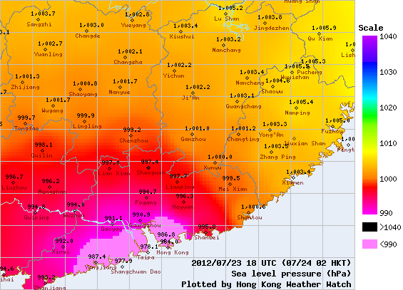
Figures 18a and 18b - VICENTE's wind radii (left) and sea-level pressure readings in southern China (right) at 02 HKT, July 24
圖 18a 及 18b - 7 月 24 日凌晨 2 時之韋森特風圈圖 (左) 及華南各地海平面氣壓讀數 (右)


Figures 19a to 19e - Wind speed time series of Cheung Chau, Cheung Chau Beach, Ngong Ping, Kowloon Star Ferry Pier and Waglan Island
圖 19a 至 19e - 長洲、長洲海灘、昂坪、九龍天星碼頭及橫瀾島的風速時間序列圖


Figures 20a to 20c - Sea level pressure at Cheung Chau, Hong Kong Observatory and Waglan Island
圖 20a 至 20c - 長洲、香港天文台及橫瀾島的海平面氣壓


Figures 21a to 21f - Radar images at 16, 19 and 22 HKT of July 23, and 01, 04 and 07 HKT of July 24. VICENTE was clearly intensifying as it neared land
圖 21a 至 21f - 7 月 23 日下午 4 、7 和 10 時,以及 24 日上午 1 、4 和 7 時之雷達圖。韋森特明顯在登陸前增強

Figure 22 - Weather chart at 05 HKT, July 24
圖 22 - 7 月 24 日上午 5 時的天氣圖

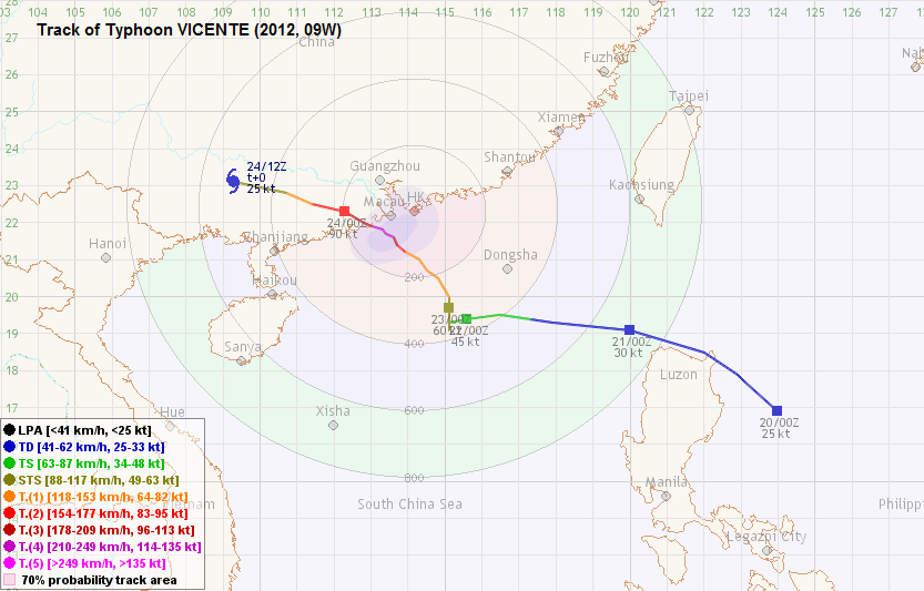
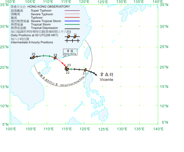
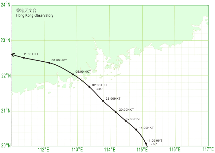
Figure 23 - VICENTE's track near Hong Kong
圖 23 - 韋森特於香港附近的路徑
| Landfall and Dissipation 登陸及消散 |
VICENTE reached its maximum strength not long before touching land. According to Chinese authorities, VICENTE made landfall at Chixi Town of Taishan City at around 04:15 HKT on July 24. The estimated 2-minute sustained wind speed of 40 m/s (144 km/h) appeared to be rather conservative as Cheung Chau's maximum 10-minute wind speed was already 141 km/h. VICENTE also accelerated and took a more westerly course after landfall, and its eye disappeared from satellite images soon after. The HKO downgraded VICENTE into a typhoon at 05 HKT, and mentioned that the No. 8 Signal would remain in force for some time. Winds at Cheung Chau dropped to gale force near sunrise. In response, the Observatory signalled in their 08 HKT bulletin that the No. 8 Signal would be replaced by the No. 3 Signal at around 10 HKT. This also meant that workers would not enjoy a half-day off and would need to travel to their workplace once public transport resumed. As daylight arrived, the damage that VICENTE brought to the territory could be seen - trees were uprooted, while debris and scaffolding was scattered around streets that would take long to clear.
The No. 3 Strong Wind Signal was issued at 10:10 HKT when winds at Cheung Chau failed to reach gale force level. VICENTE was downgraded into a severe tropical storm and was already 260 km west of the territory due to its rapid movement to the WNW inland. Public transport gradually resumed and the stock market was open in the afternoon, but schools remained closed for the day.
VICENTE travelled WNW across Guangdong and entered Guangxi in the morning. The No. 3 Signal was replaced by the No. 1 Standby Signal at 14:40 HKT when winds generally fell to below strong force level and VICENTE was downgraded into a tropical storm. Occasional squally showers were still affecting Hong Kong, but the rain intensity was not high. However, winds did not die down at various offshore locations; the Standby Signal was in force until 23:15 that night and the Strong Monsoon Signal was issued one minute later instead. It was explained that the sustained strong winds were not directly caused by VICENTE since it was already 600 km from the territory; instead they were caused by the enhancement of the southeasterly winds in the southwestern periphery of the subtropical ridge.
VICENTE later weakened into a tropical depression and turned to the southwest. The storm degenerated into a low pressure area at around 16 HKT on July 25 in northern Vietnam. During VICENTE's track on land, it produced heavy downpours and strong gusts, and was responsible for at least 5 deaths in Guangdong while 6 other went missing. The economic loss was estimated at 845 million yuan.
韋森特於登陸前不久到達顛峰強度。根據中國的資料,韋森特於 7 月 24 日上午約 4 時 15 分在台山市赤溪鎮登陸。該台估計風暴最大兩分鐘平均風力為每秒 40 米 (144 公里),但因長洲 10 分鐘平均風速已達每小時 141 公里,此估計似乎較為保守。韋森特於登陸後加速並採取較為偏西的路徑,風眼不久於衛星雲圖上消失。天文台於上午 5 時將韋森特降格為颱風,並表示八號信號將會維持一段時間。隨著長洲風力於日出前後跌至烈風程度,天文台於上午 8 時表示將於 10 時前後改發三號信號,意味著打工仔將未能得到半天休息而需於交通恢復後回到工作地點。日光到來令韋森特徹夜狂風帶來的破壞更加明顯,各區大樹倒塌,廣告牌、棚架及其他雜物碎屑佈滿一地,需長時間才能清理好。
三號強風信號最終於上午 10 時 10 分發出,長洲風速跌穿烈風下限。韋森特減弱為強烈熱帶風暴,並繼續向西北偏西快速移動,與香港的距離已增加至 260 公里。公共交通工具服務陸續恢復,股市下午重開,但學校繼續停課。
韋森特向西北偏西移動,橫過廣東,並於早上進入廣西。三號信號於下午 2 時 40 分被一號戒備信號取代,本港風勢減弱至強風以下,韋森特亦被降格為熱帶風暴。香港間中受狂風驟雨影響,但雨勢不大。此後風力沒有明顯下降,一號信號維持至晚上 11 時 15 分取消,一分鐘後發出強烈季候風信號,天文台指部分地區仍然錄得持續強風是因為副熱帶高壓脊西南沿的東南氣流疊加所致,而不是直接由韋森特帶來。
韋森特隨後減弱為熱帶低氣壓,並轉向西南移動,其後於 25 日下午 4 時在越南北部減弱為低壓區。韋森特陸上一程為所經之處帶來狂風暴雨,於廣東造成最少 5 人死亡、6 人失蹤,經濟損失估計達 8.45 億人民幣。

Figure 24 - VICENTE dissipating at northern Vietnam
圖 24 - 韋森特於越南北部消散
| Damage in Hong Kong Caused by VICENTE 韋森特為香港帶來的破壞 |
Perhaps it was fortunate that VICENTE struck Hong Kong at night. Among the more than 130 injured during the storm, 72 were admitted to hospital while none died as a result. There were more than a thousand reports of collapsing trees, amounting to more than 4,700 trees in total. Flight services were disrupted and around 136 flights were cancelled, delayed or diverted. Around a hundred passengers were stranded in the Macau side when Hong Kong-Macau jetfoil service was suspended on July 23.
Windows were shattered at some residential units over different parts of Hong Kong during the night and there were numerous accounts of flooding and water seepage. A few electricity interruptions occurred and TVB signals were also disrupted briefly due to malfunction of a transmitting station.
On August 4, the media reported that six cargos, owned by Sinopec and carrying more than 150 tonnes of plastic pellets, were blown into the sea. Although the pellets themselves were not poisonous, they could absorb poisonous substances while they were floating in the sea and may end up being consumed by humans as they went up along the food chain. The government was criticized for its slow reaction and it later set up an inter-departmental working group which focussed on the retrieval of and processing these pellets.
On the positive side, VICENTE brought the rainfall level in July back to normal after it contributed more than 300 mm of rain or around 65% of the monthly rainfall during its passage. Local weather was unstable and did not improve until July 28.
較為幸運的是韋森特於夜間來襲,傷亡得以減低。風暴中超過 130 人受傷到急症室求診,其中 72 人需留院,但沒有人死亡。政府共接獲千餘宗塌樹報告,為數約 4,700 棵樹倒塌。航空服務於風暴期間受阻,共 136 班機取消、延誤或轉飛其他地方。來往港澳的飛航服務於 7 月 23 日下午暫停後,約 100 人滯留澳門外港碼頭。
香港部分地方住宅窗戶當晚於狂風中損毀並滲水,亦有多個水浸報告。電力供應曾多次不穩,無線電視一個發射站故障令信號短暫受影響。
8 月 4 日,傳媒報導中石化 6 個載有膠粒、共重超過 150 噸的貨櫃在風暴吹襲期間墮海,膠粒隨海流漂浮至其他地方。雖然膠粒本身無毒,但在漂浮期間可能吸收毒素,隨食物鏈進入人體。政府因為反應遲緩而受批評,其後設立跨部門工作小組負責撈起膠粒及善後工作。
另一方面,韋森特襲港期間共帶來超過 300 毫米雨量,為全月的百分之 65,令 7 月雨量達正常水平。本地天氣於風暴吹襲後仍不穩定,直至 28 日才見好轉。

Figure 25 - Collapsed trees at Quarry Bay. Source: here
圖 25 - 鰂魚涌有樹木被狂風吹倒。圖片來源:按此

Figure 26 - Traffic sign collapsed on a taxi at Ngau Chi Wan. Source: AM730
圖 26 - 牛池灣有路牌擊中的士。圖片來源:AM730

Figure 27 - Plastic pellets retrieved on a beach. Source: here
圖 27 - 於海灘上撈獲的膠粒。圖片來源:按此
| Winds Recorded at Reference Stations 參考站所錄得的風速 |
| Station 風速站 |
Max. 10-min avg. wind speed 最高十分鐘平均風速 |
Beaufort classification 蒲福氏風級分類 |
| Chek Lap Kok 赤鱲角 | 95 km/h | STORM 暴風 |
| Cheung Chau 長洲 | 141 km/h | HURRICANE 颶風 |
| Kai Tak 啟德 | 85 km/h | GALE 烈風 |
| Sai Kung 西貢 | 82 km/h | GALE 烈風 |
| Sha Tin 沙田 | 46 km/h | STRONG 強風 |
| Ta Kwu Ling 打鼓嶺 | 47 km/h | STRONG 強風 |
| Tsing Yi (SHL) 青衣蜆殼油庫 | 51 km/h | STRONG 強風 |
| Wetland Park 濕地公園 | 50 km/h | STRONG 強風 |
| Number of stations recording at least STRONG force (force 6 - 7) winds: | 8 |
| Number of stations recording at least GALE force (force 8 - 9) winds: | 4 |
| Number of stations recording at least STORM force (force 10 - 11) winds: | 2 |
| Number of stations recording HURRICANE force (force 12) winds: | 1 |
| 錄得 強風 (6 - 7 級) 或更高風速的站數: | 8 |
| 錄得 烈風 (8 - 9 級) 或更高風速的站數: | 4 |
| 錄得 暴風 (10 - 11 級) 或更高風速的站數: | 2 |
| 錄得 颶風 (12 級) 風速的站數: | 1 |
| Charts and Figures 各項數據 |
Table 1: Track data from HKWW:
表一 : 香港天氣觀測站之路徑資料
YYMMDDZZ Lat Long Wind |
Table 2: Maximum gust and hourly average wind speed recorded in Hong Kong from HKO:
表二 : 香港天文台公佈的各站最高每小時平均風力和陣風數據
| Station |
Maximum Gust |
Maximum Hourly Mean Wind |
||||||
Direction |
Speed (km/h) |
Date/Month |
Time |
Direction |
Speed (km/h) |
Date/Month |
Time |
|
| Central Pier | ENE |
122 |
23/7 |
22:39 |
E |
76 |
23/7 |
23:00 |
| Cheung Chau | E |
184 |
24/7 |
00:17 |
SE |
126 |
24/7 |
02:00 |
| Cheung Chau Beach | E |
171 |
23/7 |
23:54 |
E |
115 |
24/7 |
00:00 |
| Green Island | NE |
155 |
23/7 |
23:20 |
NE |
92 |
23/7 |
21:00 |
| Hong Kong International Airport | E |
133 |
24/7 |
01:34 |
E |
85 |
24/7 |
01:00 |
| Kai Tak | E |
135 |
24/7 |
01:34 |
ESE |
67 |
24/7 |
07:00 |
| King's Park | ESE |
110 |
24/7 |
01:26 |
ESE |
52 |
24/7 |
02:00 |
| Lau Fau Shan | - |
106 |
24/7 |
00:27 |
- |
59 |
24/7 |
00:00 |
| Ngong Ping | ENE |
256 |
23/7 |
23:48 |
E |
153 |
24/7 |
02:00 |
| North Point | E |
130 |
24/7 |
00:33 |
E |
65 |
24/7 |
00:00 |
E |
65 |
24/7 |
01:00 |
|||||
| Peng Chau | ESE |
128 |
24/7 |
01:28 |
E |
90 |
24/7 |
01:00 |
| Ping Chau | E |
121 |
23/7 |
21:09 |
E |
41 |
23/7 |
22:00 |
| Sai Kung | ENE |
121 |
23/7 |
21:26 |
ENE |
72 |
23/7 |
22:00 |
| Sha Chau | SSE |
126 |
24/7 |
03:31 |
SE |
85 |
24/7 |
03:00 |
| Sha Lo Wan | E |
149 |
24/7 |
02:06 |
E |
76 |
24/7 |
02:00 |
| Sha Tin | SSE |
88 |
24/7 |
02:54 |
SE |
41 |
24/7 |
05:00 |
| Shek Kong | ENE |
121 |
24/7 |
01:33 |
E |
58 |
24/7 |
02:00 |
| Star Ferry (Kowloon) | E |
122 |
24/7 |
00:33 |
E |
83 |
24/7 |
00:00 |
| Ta Kwu Ling | ENE |
94 |
24/7 |
01:11 |
E |
40 |
24/7 |
03:00 |
| Tai Mei Tuk | ENE |
146 |
23/7 |
19:20 |
E |
96 |
24/7 |
01:00 |
| Tai Mo Shan | ESE |
196 |
24/7 |
01:01 |
ESE |
135 |
24/7 |
01:00 |
| Tate's Cairn | ESE |
166 |
23/7 |
23:45 |
E |
115 |
24/7 |
00:00 |
| Tseung Kwan O | ESE |
101 |
24/7 |
01:58 |
ESE |
36 |
24/7 |
05:00 |
| Tsing Yi Shell Oil Depot | SE |
106 |
24/7 |
01:42 |
ESE |
43 |
24/7 |
01:00 |
| Tuen Mun Government Offices | ESE |
128 |
24/7 |
02:26 |
ESE |
43 |
24/7 |
03:00 |
| Waglan Island | ESE |
149 |
23/7 |
22:10 |
E |
106 |
23/7 |
22:00 |
| Wetland Park* | E |
94 |
24/7 |
01:06 |
E |
40 |
24/7 |
01:00 |
E |
40 |
24/7 |
02:00 |
|||||
SE |
40 |
24/7 |
04:00 |
|||||
| Wong Chuk Hang | E |
124 |
24/7 |
01:18 |
ESE |
51 |
24/7 |
01:00 |
* Backup station of Wetland Park 濕地公園後備測風站
Table 3: Rainfall (in millimetres) contributed by VICENTE from HKO (figures in brackets are based on incomplete hourly data):
表三 : 香港天文台公佈的各站雨量資料 (方括號內之數據由不完整之每小時資料擷取)
| Station | 21-Jul |
22-Jul |
23-Jul |
24-Jul |
Total(mm) |
|
| Hong Kong Observatory | 2.2 |
1.0 |
112.0 |
99.5 |
214.7 |
|
| Hong Kong International Airport (HKA) | 2.6 |
1.7 |
98.4 |
162.2 |
264.9 |
|
| Cheung Chau (N26) | 1.0 |
1.5 |
85.0 |
117.5 |
205.0 |
|
| N05 | Fanling | 2.0 |
6.5 |
101.5 |
106.0 |
216.0 |
| N13 | High Island | 21.5 |
5.5 |
81.5 |
44.5 |
153.0 |
| K04 | Jordan Valley | 5.5 |
3.0 |
130.0 |
119.0 |
257.5 |
| N06 | Kwai Chung | 1.5 |
4.0 |
139.5 |
125.5 |
270.5 |
| H12 | Mid Levels | 5.5 |
4.5 |
138.5 |
135.0 |
283.5 |
| N09 | Sha Tin | 9.0 |
10.0 |
176.0 |
155.0 |
350.0 |
| H19 | Shau Kei Wan | 4.5 |
4.0 |
72.5 |
59.0 |
140.0 |
| SEK | Shek Kong | 1.0 |
9.0 |
169.0 |
175.5 |
354.5 |
| K06 | So Uk Estate | 1.5 |
4.0 |
158.0 |
132.0 |
295.5 |
| R31 | Tai Mei Tuk | 8.5 |
6.0 |
116.0 |
80.0 |
210.5 |
| R21 | Tap Shek Kok | 0.0 |
2.0 |
92.0 |
141.5 |
235.5 |
| N17 | Tung Chung | 2.0 |
4.0 |
116.0 |
207.5 |
329.5 |
| R27 | Yuen Long | 0.0 |
3.5 |
118.5 |
134.0 |
256.0 |
Last Accessed 最近訪問日期: Fri Apr 19 2024 19:50:29 HKT
Last Modified 最近修訂日期: Mon Jul 24 2023
