
TC Watch / 熱帶氣旋 > Selected TC Review / 重要熱帶氣旋回顧 > 201215W (TEMBIN 天秤) [Refresh 更新]
 201215W (TEMBIN 天秤) - Profile 檔案 201215W (TEMBIN 天秤) - Profile 檔案 |
(Issued on December 31, 2012)
(於 2012 年 12 月 31 日發出)
Brief profile of TEMBIN 天秤小檔案:
| JTWC number 聯合颱風警報中心 (JTWC) 號碼 | 15W |
| International number 國際編號 | 1214 |
| Period of existence 生存時期 (JTWC) | 2012/08/19 08 HKT - 2012/08/30 08 HKT |
| Lifetime 壽命 (JTWC) | 11.00 days 日 |
| Maximum 1-minute wind (JTWC) JTWC 一分鐘平均最高中心風速 | 115 knots 節 (Category 4 Typhoon 四級颱風) |
| Minimum pressure (JTWC) JTWC 最低氣壓 | 937 hPa 百帕 |
| Highest TC signal by HKO (if applicable) 香港天文台發出最高熱帶氣旋警告信號 |
1 (Standby Signal 戒備信號) |
| Closest point of approach by HKO (if applicable) 香港天文台所示之最接近距離 (如適用) |
ESE 300 km (real-time warning 實時報告) / 290 km (TC report 熱帶氣旋報告) |
| Time of closest approach by HKO (if applicable) 香港天文台所示之最接近時間 (如適用) |
Around 約 2012/08/26 01-02 HKT (real-time warning 實時報告) / 01 HKT (TC report 熱帶氣旋報告) |
| Lowest pressure recorded at HKO (if applicable) 香港天文台錄得的最低氣壓 (如適用) |
999.6 hPa 百帕 (2012/08/26 16:26 HKT) |
TC signals for Hong Kong & Track 香港曾經生效的熱帶氣旋警告和路徑圖:
Table 表:
| Signal 信號 |
Date and time 日期和時間 |
Distance from HK 與香港的距離 |
Predicted movement 預測移動方向和速度 |
Max. 10-min winds 中心最高十分鐘平均風速 |
 |
2012/08/24 (FRI) 22:40 HKT | E 530 km | W / WSW at 10 km/h | 120 km/h (65 knots, CAT. 1 / TY) |
 |
2012/08/26 (SUN) 16:45 HKT | ESE 330 km | S slowly → E at 10 km/h | 145 km/h (78 knots, CAT. 1 / TY) |
Figure 圖:
(Track courtesy of Lorenzo. Data from HKO. 鳴謝 Lorenzo 提供路徑圖,資料取自天文台)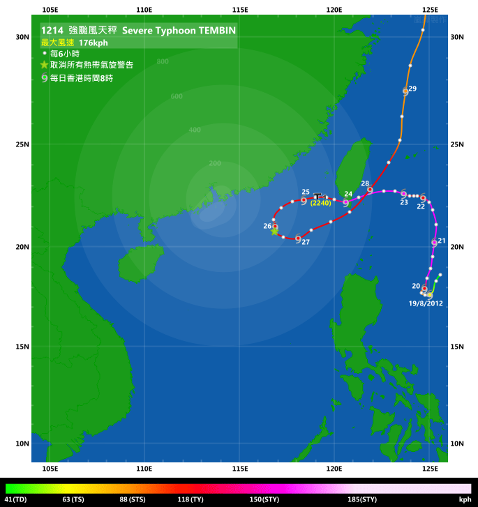
Percentile Ranks 百分等級:
Percentile ranks are only available for cyclones that necessitated at least the No. 3 Strong Wind Signal. 百分等級只適用於曾令天文台發出三號強風信號 (或更高) 的熱帶氣旋。IR imagery animation 紅外線雲圖動畫:
TC track from HKWW 本站的熱帶氣旋路徑圖:
Not available as no bulletins were issued. 由於本網並未對此熱帶氣旋作出發佈,路徑圖未能提供。
TC track from HKO 天文台的熱帶氣旋路徑圖:

| Past HKWW Bulletins on TEMBIN 本站有關天秤的發佈 |
No bulletins were issued for the storm. 本網並未對天秤作出發佈。
| Storm Formation and Development 氣旋形成和發展 |
Unless otherwise stated, all times below are in Hong Kong Standard Time (UTC+8). Bulletins of TEMBIN from WTW and HKWWSIC were referenced during the compilation of this review; the webmaster thanks the operators of the two sites for their generous support.
除非特別註明,下文時間均為香港標準時間 (協調世界時加 8 小時)。網主於撰寫此回顧時曾參考世界熱帶氣旋網及香港惡劣天氣訊息站對天秤的發佈,謹此致謝。
TEMBIN's track was arguably one of the most unusual this year. The cyclone experienced cycles of intensification and weakening, and was the sole storm in 2012 that necessitated only the No. 1 Standby Signal.
A tropical disturbance persisted east of Luzon just as KAI-TAK struck western Guangdong in mid-August. The disturbance was upgraded by the JTWC into tropical depression 15W at 8 am on August 19 while moving southwards under the influence of a ridge west of the system. Initial prediction called for a reversal in direction as the subtropical ridge east of 15W strengthened, followed by a gradual turn to the west as the ridge would then extend rapidly. Meanwhile, the JMA upgraded 15W into tropical storm status at the same time, naming it TEMBIN. It is the Japanese name for the constellation Libra.
TEMBIN benefited from high sea temperatures, low wind shear and good divergence aloft, and consolidated quickly. On August 20, an eye emerged from TEMBIN's central dense overcast, prompting agencies to make successive upgrades. The JTWC's strength estimate jumped from 55 knots at 2 am to 110 knots at 8 pm, while the JMA's upgrade was from 45 knots to 90 knots. The HKO upgraded TEMBIN into a severe tropical storm at 9 pm August 19, then a typhoon at 6 am August 20, and further into severe typhoon at 4 pm the same day.
By August 20, it was clear from steering charts that the eastern ridge resumed steering influence, and TEMBIN slowly made its way to the north. The extension of the subtropical ridge was blocked by another developing cyclone BOLAVEN. TEMBIN drifted northwards steadily on August 21, with forecasts depicting a sharp turn to the west and approaching the vicinity of Hong Kong 4 to 5 days later.
天秤的路徑可算是今年較為奇特的一條。風暴經歷多次增強減弱週期,亦為本年唯一一個令香港天文台只發出一號戒備信號的熱帶氣旋。
颱風啟德於八月中侵襲廣東的同時,一個熱帶擾動於呂宋以東海域形成。該擾動於 8 月 19 日早上 8 時被 JTWC 升格為熱帶低氣壓 15W,當時它正受西面脊場影響而南移。該台首佈預計 15W 東面的副熱帶高壓脊即將增強,令 15W 轉為向北移,隨後副高大舉西伸令 15W 向西移動。與此同時,JMA 將 15W 升格為熱帶風暴,並將之命名為天秤。該名稱由日本提供,意思為天秤座。
天秤受惠於高海溫,低風切及良好高空輻散而快速整合。它於 20 日在中心密集雲區裡發展出風眼,各機構紛紛多次調高強度。JTWC 於凌晨 2 時的強度估值為 55 節,至當晚 8 時調升至 110 節,而 JMA 則由 45 節逐步調高至 90 節。天文台於 19 日晚 9 時升格天秤為強烈熱帶風暴,20 日早上 6 時為颱風,同日下午 4 時更升為強颱風。
至 20 日,從駛流圖已明顯見到東面脊場成為主要驅動力,天秤開始緩慢北移,而副高的西伸受另一正發展氣旋布拉萬阻礙。天秤於 21 日穩定北移,路徑預測為天秤急轉西移,並於 4 至 5 日後靠近香港。


Figures 1a and 1b - Satellite images of TEMBIN on August 20 and 22. The developing cyclone to its right is BOLAVEN.
圖 1a 及 1b - 天秤於 8 月 20 及 22 日的衛星雲圖,在其右面發展的是氣旋布拉萬。

Figure 2 - TEMBIN at peak intensity
圖 2 - 天秤達到巔峰強度

Figure 3 - JTWC's forecast showing TEMBIN would reach seas near Hong Kong on August 26
圖 3 - JTWC 預測天秤於 8 月 26 日靠近香港鄰近海域
| Approaching Taiwan and South China Sea 靠近台灣及南海 |
The ridge extended rapidly westwards into China on August 21. TEMBIN responded by making a 90-degree turn to the west early on August 22, approaching southern Taiwan slowly. However, due to blocked outflow channels, the storm weakened significantly during August 21 and 22 as the storm became slightly asymmetrical. TEMBIN accelerated on August 23 and dipped southwards slightly due to the shape of the ridge. It intensified again prior to landfall with the development of a clear eye, and many agencies upgraded the storm back to levels attained on August 20. It was perhaps strange that the JMA never acknowledged such re-intensification, fixing its strength at 75 knots which was significantly lower than the estimates of other agencies and was probably underestimated.
TEMBIN made landfall at Mudan, Pingtung at around 5 am on August 24. Due to the low latitude of its landfall, TEMBIN entered sea again three hours later at Fangshan, Pingtung. However, this brief landfall was already sufficient to weaken the system considerably. The effect was seen more fully after TEMBIN entered South China Sea with convections becoming loose in its western periphery. By that time all agencies were predicting Fujiwara effect between TEMBIN and BOLAVEN, as the latter, now being more intense and larger, approached the Ryukyu Islands. TEMBIN, being the western storm, would loop anticlockwise while BOLAVEN travelled northwards. After BOLAVEN left, the subtropical ridge east of TEMBIN would extend and push TEMBIN northwards as well.
Locally, it was very hot starting from August 24 as TEMBIN's subsidence affected the territory. Winds turned northerly, bringing hot continental air mass and hazy weather. As TEMBIN moved west and edged closer to Hong Kong, the Observatory issued the No. 1 Standby Signal at 10:40 pm on August 24. At that time, TEMBIN was situated around 530 km east of Hong Kong as a marginal typhoon. Although there was high certainty that TEMBIN would eventually retreat, it was uncertain how far into the South China Sea it would dig and the Signal was issued to warn the public of such potential danger.
TEMBIN continued to move west steadily, approaching the 400-km circle at around noon on August 25. After that the storm started to move southwest, but its distance to Hong Kong was still decreasing slowly. Fresh north to northwesterly winds were observed in some parts of the territory, but the weather remained fine and hazy. TEMBIN decelerated late on August 25 and made its closest point of approach at around 1 am on August 26 at around 290 km to the east-southeast.
副高於 21 日大幅西伸至中國,天秤於 22 日早上轉為西移,慢慢靠近台灣。但是,由於輻散通道受阻,天秤於 21 及 22 日明顯減弱,風暴變得稍不對稱。天秤於 23 日加速,受副高型態影響而稍微南移。它於登陸前再度增強,風眼清晰可見,多個站台提升其強度至 20 日前後所達到的巔峰。可是,JMA 並沒有提高強度估值,只維持於減弱後的 75 節,明顯比其他機構為低並可能低估其強度。
天秤於 24 日約上午 5 時在屏東牡丹登陸。由於登陸緯度低,天秤於三小時後便於屏東枋山入海,但短暫登陸已足以令其大幅減弱。天秤進入南海後其減弱趨勢漸變明顯,西面對流變得鬆散。那時各機構均預測天秤將與布拉萬發生藤原效應,隨著布拉萬增強變大並靠近琉球群島,處於西面的天秤將逆時針打轉,至布拉萬北上離開後副高西伸並使天秤北移。
本地方面,自 24 日開始受天秤周邊的下沉氣流影響吹偏北風,大陸氣團為香港帶來酷熱有煙霞的天氣。隨著天秤西移並靠近本港,天文台於 24 日下午 10 時 40 分發出一號戒備信號,當時天秤處於香港以東約 530 公里,強度為颱風下限。雖然幾乎肯定天秤最終會東退,但未能肯定它深入南海的幅度,戒備信號正能警告公眾此不確定性。
天秤繼續西移,於 25 日中午前後到達香港 400 公里範圍,隨後風暴轉為向西南移,但繼續慢慢靠近香港。本地部分地方吹清勁北至西北風,但天色仍然明朗並有煙霞。天秤於 25 日較後時間減速,於 26 日凌晨約 1 時最接近香港,當時它位處本港東南偏東約 290 公里。


Figures 4a and 4b - Forecast tracks from different agencies on August 22 and 24
圖 4a 及 4b - 各站於 8 月 22 及 24 日的預測路徑

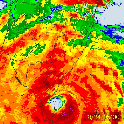
Figures 5a and 5b - Radar images from CWB showing TEMBIN's eye as it made landfall at southern Taiwan on August 24. Images saved by HKSON.
圖 5a 及 5b - CWB 於 8 月 24 日的雷達圖顯示天秤的風眼並登陸台灣南部。影像由 HKSON 儲存。

Figure 6 - Steering chart at 14 HKT, August 25. TEMBIN and BOLAVEN were interacting with each other.
圖 6 - 8 月 25 日下午 2 時之駛流圖,當時天秤及布拉萬正互相影響。

Figure 7 - Radar image at the time of closest approach
圖 7 - 天秤最接近香港時之雷達圖像

Figure 8 - Wind field plot at 6:32 am, August 26
圖 8 - 8 月 26 日早上 6 時 32 分之風場圖
| Leaving South China Sea and Northward Journey 離開南海及北上 |
Interaction between TEMBIN and BOLAVEN became apparent on August 26 as TEMBIN reversed its direction, and the anticyclone that developed at low latitudes in the Philippine Sea also appeared to help in such reversal. TEMBIN also re-intensified into a category 3 typhoon that afternoon as its eye emerged again on satellite images. However this intensification was brief and, as a result of restricted outflow and supply of moisture due to the presence of BOLAVEN, TEMBIN's eastern semicircle was almost devoid of deep convections just half a day later. In Hong Kong, the Standby Signal was lifted at 4:40 pm on August 26 as it was clear that TEMBIN would not approach the territory further.
Although TEMBIN lacked deep convections in its eastern periphery, its low-level structure was good and it maintained typhoon strength on August 27 as it turned northeastward, approaching Taiwan for the second time. At this position Hong Kong was again affected by very hot and hazy weather. The temperature at the Observatory rose to 34.5 degrees on August 28, the highest of the year. By that time BOLAVEN had moved to above 30°N and the subtropical ridge could extend westwards at TEMBIN's latitude. TEMBIN skirted just off the coast of Hengchun on August 28 and started to accelerate northwards. Shear increased significantly and TEMBIN appeared looser than before. It weakened into a severe tropical storm that day and travelled along the East China Sea on August 29. Some previous forecasts put the storm into eastern China but this scenario never materialized as the ridge did not extend that far. TEMBIN eventually turned north-northeast and made landfall at southwestern South Korea at around 10 am on August 30 as a tropical storm. This brought more rainfall to the Korean Peninsula, having just struck by BOLAVEN a few days ago. TEMBIN completed extratropical transition later that day as it moved to the eastern side of the Peninsula.
天秤與布拉萬之間的相互影響於 26 日變得明顯,天秤當天開始退出南海,於菲律賓以東海域的一個反氣旋亦助其東移。天秤的風眼再次展現,風暴增強為三級颱風,但增強趨勢短暫。布拉萬的存在令輻散及水氣供應轉差,天秤東半圓於半日後幾乎沒有深層對流。香港方面,天文台於肯定天秤不會繼續靠近本港後,在 26 日下午 4 時 40 分取消一號戒備信號。
雖然天秤東面缺乏深層對流,但其低層結構還是非常緊密,它於 27 日維持颱風強度並轉向東北移動,再度靠近台灣。天秤於此地令香港繼續受酷熱煙霞天氣影響,天文台於 28 日錄得最高氣溫 34.5 度,為本年的最高紀錄。布拉萬當時已移至北緯 30 度以北,副高終能於天秤緯度一帶西伸。天秤於 28 日在恆春近海掠過,並開始向北加速。由於垂直風切變明顯提升,天秤呈減弱之勢,組織變得鬆散。它於當天減弱為強烈熱帶風暴,於 29 日沿東海北上。先前部分預測預計天秤會登陸中國東部,但由於副高並未如此大幅西伸而未有實現。天秤最終轉向東北偏北,於 30 日上午約 10 時在南韓西南部以熱帶風暴強度登陸。天秤為繼布拉萬後數天內第二個熱帶氣旋侵襲朝鮮半島,再次為該區帶來大雨。天秤於當天稍後移至朝鮮半島東面,並轉化為溫帶氣旋。

Figure 9 - Satellite image of TEMBIN and BOLAVEN on August 26. TEMBIN had re-intensified.
圖 9 - 衛星雲圖顯示天秤及布拉萬的位置,當時天秤已再次增強。

Figure 10 - TEMBIN neared Taiwan for the second time on August 28. Its low-level structure was still compact.
圖 10 - 天秤於 8 月 28 日再次靠近台灣,其低層結構仍然緊密。

Figure 11 - Distance (km) and bearing of TEMBIN from BOLAVEN during August 22 - 29. The anticlockwise revolution is clear.
圖 11 - 天秤於 8 月 22 至 29 日相對布拉萬的距離 (公里) 及方位角,明顯可見兩者以逆時針方向旋轉。

Figure 12 - TEMBIN making landfall in South Korea on August 30
圖 12 - 天秤於 8 月 30 日登陸南韓
| Winds Recorded at Reference Stations 參考站所錄得的風速 |
(Except for special cases, this section is not available for cyclones that only necessitated the Standby Signal 除非特別情況,否則此部只當氣旋令天文台發出三號或更高信號時提供)
| Charts and Figures 各項數據 |
Table 1: Track data from JTWC:
表一 : 聯合颱風警報中心之路徑資料
ID Name YYMMDD ZZZZ Lat Long Basin Wind Pres 15W TEMBIN 120830 0600 35.5N 127.6E WPAC 35 996 |
Table 2: Maximum gust and hourly average wind speed recorded in Hong Kong from HKO:
表二 : 香港天文台公佈的各站最高每小時平均風力和陣風數據
| Station | Maximum Gust |
Maximum Hourly Mean Wind |
||||||
Direction |
Speed (km/h) |
Date/Month |
Time |
Direction |
Speed (km/h) |
Date/Month |
Time |
|
| Bluff Head (Stanley) | N |
36 |
26/8 |
02:29 |
NW |
13 |
25/8 |
14:00 |
| Central Pier | W |
36 |
25/8 |
13:01 |
W |
22 |
25/8 |
08:00 |
| Cheung Chau | NNE |
47 |
25/8 |
22:45 |
NNE |
30 |
26/8 |
00:00 |
| Cheung Chau Beach | NE |
45 |
25/8 |
22:43 |
NE |
22 |
26/8 |
00:00 |
| Green Island | NNE |
54 |
25/8 |
22:59 |
N |
36 |
26/8 |
10:00 |
| Hong Kong International Airport | NNW |
36 |
25/8 |
09:46 |
NNW |
31 |
25/8 |
11:00 |
| Kai Tak | N |
49 |
26/8 |
02:05 |
WNW |
20 |
25/8 |
08:00 |
N |
20 |
25/8 |
23:00 |
|||||
| King's Park | NNE |
40 |
25/8 |
23:04 |
NNE |
16 |
25/8 |
23:00 |
NE |
40 |
26/8 |
04:13 |
|||||
| Lau Fau Shan | N |
43 |
25/8 |
23:02 |
WNW |
25 |
25/8 |
18:00 |
| Ngong Ping | N |
51 |
25/8 |
06:33 |
NE |
30 |
26/8 |
00:00 |
| North Point | NNE |
38 |
25/8 |
22:51 |
W |
20 |
25/8 |
16:00 |
| Peng Chau | N |
47 |
25/8 |
22:32 |
NW |
25 |
25/8 |
15:00 |
| Ping Chau | NNE |
30 |
26/8 |
00:25 |
NW |
7 |
25/8 |
06:00 |
| Sai Kung | N |
47 |
26/8 |
10:55 |
N |
25 |
26/8 |
11:00 |
| Sha Chau | NNW |
47 |
25/8 |
09:17 |
N |
31 |
26/8 |
08:00 |
| Sha Lo Wan | N |
31 |
25/8 |
22:33 |
NNE |
13 |
26/8 |
00:00 |
| Sha Tin | NE |
34 |
26/8 |
12:07 |
N |
14 |
26/8 |
11:00 |
| Shek Kong | WNW |
30 |
26/8 |
14:33 |
NW |
13 |
25/8 |
15:00 |
| Star Ferry (Kowloon) | W |
34 |
25/8 |
13:12 |
W |
25 |
25/8 |
13:00 |
| Ta Kwu Ling | N |
27 |
26/8 |
12:51 |
N |
12 |
26/8 |
12:00 |
| Tai Mei Tuk | NNE |
47 |
26/8 |
08:50 |
NNE |
23 |
25/8 |
23:00 |
NNE |
23 |
26/8 |
00:00 |
|||||
| Tai Mo Shan | NNE |
63 |
26/8 |
03:22 |
NNE |
47 |
25/8 |
23:00 |
| Tai Po Kau | WNW |
36 |
25/8 |
09:52 |
NW |
16 |
25/8 |
14:00 |
| Tap Mun | N |
34 |
26/8 |
11:27 |
WNW |
19 |
25/8 |
08:00 |
| Tate's Cairn | NNW |
70 |
26/8 |
02:42 |
N |
45 |
25/8 |
23:00 |
| Tseung Kwan O | E |
31 |
26/8 |
05:34 |
N |
13 |
26/8 |
13:00 |
NNW |
13 |
26/8 |
15:00 |
|||||
| Tsing Yi Shell Oil Depot | NW |
36 |
26/8 |
12:04 |
NNW |
16 |
26/8 |
12:00 |
| Tuen Mun Government Offices | WNW |
41 |
25/8 |
12:23 |
WNW |
14 |
25/8 |
14:00 |
| Waglan Island | N |
45 |
26/8 |
06:01 |
N |
38 |
26/8 |
07:00 |
| Wetland Park | NNW |
27 |
26/8 |
14:02 |
NNW |
13 |
25/8 |
13:00 |
| Wong Chuk Hang | N |
38 |
26/8 |
10:04 |
NNW |
14 |
26/8 |
14:00 |
Table 3: Rainfall (in millimetres) contributed by TEMBIN from HKO (figures in brackets are based on incomplete hourly data):
表三 : 香港天文台公佈的各站雨量資料 (方括號內之數據由不完整之每小時資料擷取)
| Station | 24 Aug | 25 Aug | 26 Aug | Total (mm) |
| Hong Kong Observatory | 0.0 | Trace | 0.0 | Trace |
| Tai Mo Shan | 0.5 | 0.0 | 0.0 | 0.5 |
| Sok Kwu Wan | 0.0 | 2.5 | 0.0 | 2.5 |
No rainfall at other stations. 其他雨量站並無錄得降雨。
Last Accessed 最近訪問日期: Thu Apr 18 2024 15:09:48 HKT
Last Modified 最近修訂日期: Mon Jul 24 2023
