
TC Watch / 熱帶氣旋 > Selected TC Review / 重要熱帶氣旋回顧 > 201226W (BOPHA 寶霞) [Refresh 更新]
 201226W (BOPHA 寶霞) - Profile 檔案 201226W (BOPHA 寶霞) - Profile 檔案 |
(Issued on December 23, 2012)
(於 2012 年 12 月 23 日發出)
Brief profile of BOPHA 寶霞小檔案:
| JTWC number 聯合颱風警報中心 (JTWC) 號碼 | 26W |
| International number 國際編號 | 1224 |
| Period of existence 生存時期 (JTWC) | 2012/11/26 02 HKT - 2012/12/09 08 HKT |
| Lifetime 壽命 (JTWC) | 13.25 days 日 |
| Maximum 1-minute wind (JTWC) JTWC 一分鐘平均最高中心風速 | 140 knots 節 (Category 5 Super Typhoon 五級超級颱風) |
| Minimum pressure (JTWC) JTWC 最低氣壓 | 918 hPa 百帕 |
| Highest TC signal by HKO (if applicable) 香港天文台發出最高熱帶氣旋警告信號 |
N/A 不適用 |
| Closest point of approach by HKO (if applicable) 香港天文台所示之最接近距離 (如適用) |
N/A 不適用 |
| Time of closest approach by HKO (if applicable) 香港天文台所示之最接近時間 (如適用) |
N/A 不適用 |
| Lowest pressure recorded at HKO (if applicable) 香港天文台錄得的最低氣壓 (如適用) |
N/A 不適用 |
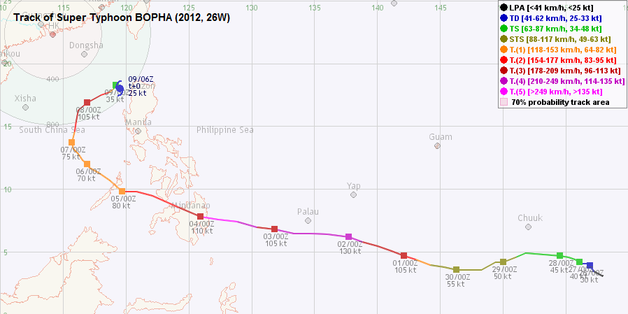
TC track from HKWW 本站的熱帶氣旋路徑圖:
| Past HKWW Bulletins on BOPHA 本站有關寶霞的發佈 |
Please click here for bulletins on BOPHA. 請按這裡。
| Storm Summary 氣旋摘要 |
Unless otherwise stated, all times below are in Hong Kong Standard Time (UTC+8)
除非特別註明,下文時間均為香港標準時間 (協調世界時加 8 小時)
BOPHA is the third category 5 super typhoon in the northwest Pacific Ocean this year.
The cyclone originated from a very low latitude. A disturbance southeast of Chuuk was spotted and it became this year's 26th tropical depression early on November 26 at a latitude of 3.6°N. It was generally expected that 26W would have significant potential of becoming a severe storm as it was not projected to recurve early; rather it would stay at low latitudes where ocean heat content was high enough. At its formation, 26W was too south to be influenced by the subtropical ridge north of it, and therefore initial movement was slow.
26W's structure gradually stabilized and it was upgraded into tropical storm status by the JMA at 2 am on November 27. The name assigned was BOPHA. Contributed by Cambodia, BOPHA could mean either flower or a little girl. BOPHA was forecast to move west at increasing speed as more influence from the subtropical ridge would be expected as BOPHA gained latitude. However, due to the orientation of the ridge, BOPHA started to lose latitude on November 28, going back to around 4°N. BOPHA did not gain much intensity during these two days despite being in a favourable environment, which might be due to a lack of Coriolis force necessary to sustain the cyclonic motion.
As a result of the southward movement, agencies shifted their forecast track westwards and predicted landfall at southern Philippines. BOPHA eventually intensified into a severe tropical storm on November 29 in 1-minute average wind standard or November 30 in 10-minute standard. The subtropical ridge extended southwards east of the storm, and BOPHA started to move WNW. Still below 5°N, BOPHA intensified into a typhoon later on November 30 as it developed a central dense overcast and its eye emerged. The storm underwent its first rapid deepening early on December 1 when it intensified from category 1 (70 knots) to category 4 (115 knots) in 12 hours, according to the JTWC. BOPHA's central dense overcast expanded in size with decreasing cloud top temperatures, while peripheral spiraling bands diminished. The JMA's estimated strength at 8 am on December 1 was 90 knots, while Chinese authorities were estimating BOPHA's strength at around 50 m/s (97 knots). The estimated intensities were revised upwards during the day, with the JTWC upgrading the storm into a super typhoon (130 knots). However, the eye became smaller towards the end of the day and cloud top temperature increased. The storm weakened substantially on December 2 but maintained category 3 strength. With forecasts then extending to the South China Sea, models and agencies agreed that the subtropical ridge would weaken and that BOPHA would travel increasingly poleward at reduced speeds while in the Sea.
BOPHA turned westwards again late on December 2. As a result Palau was spared a direct hit, with damages much more minor than anticipated. However, BOPHA's eye re-emerged and intensified again on December 3, reaching category 5 status (140 knots) at 8 pm that day. Colour-enhanced satellite images showed a symmetric and very well-defined central dense overcast with embedded eye. JMA's strength estimate was 100 knots, while CMA's estimate was 60 m/s (117 knots). At 7.4°N, BOPHA is the closest storm to the equator at such a strength according to JTWC's best track, the previous record being Typhoon LOUISE at 7.8°N on November 17, 1964 [See Note 1]. The storm made landfall in the province of Baganga at around 3 am on December 4 at its peak strength. The eye disappeared an hour after landfall, and BOPHA resumed WNW motion. BOPHA crossed Mindanao and entered sea again near Iligan City at 2 pm, as a category 2 typhoon. Terrain effect caused BOPHA's movement to become erratic, but it eventually turned NW on December 5 as it crossed Palawan. Due to the strength of the storm, BOPHA caused severe damage to southern Philippines with death toll surpassing 1,000 and another 800 missing.
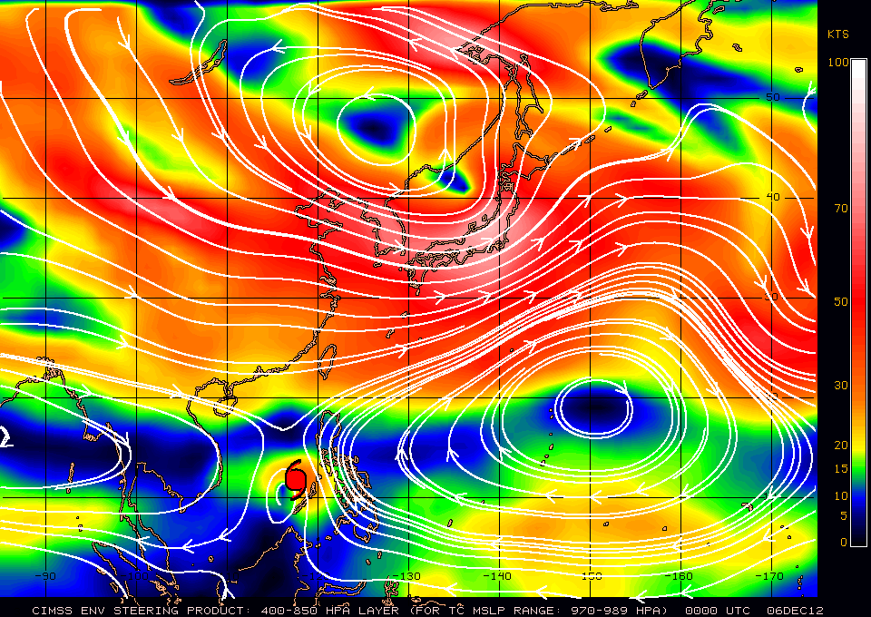
By December 6 the western edge of the subtropical ridge had retreated to western Philippines. This positioned BOPHA in a pressure col and its speed of movement slowed down to around 12 to 15 km/h. An intense surge of northeast monsoon was spreading southwards in southern China at that time; this added uncertainty to BOPHA's track as it was uncertain whether BOPHA would loop and turn southwards, much like Typhoon CIMARON in 2006 and Severe Tropical Storm MAYSAK in 2008, or it could recurve in the South China Sea.
Improved divergence associated with the mid-latitude trough that caused the ridge to retreat helped ventilation and BOPHA intensified again as it moved northwards on December 7. Due to the rapid appearance of the eye and the brief period that it persisted, it was rather difficult to tell BOPHA's exact peak strength in the South China Sea attained at around 8 pm that day, but estimates from JMA, HKO and CMA were close to 90 knots and that from JTWC was 110 knots (category 3), this being revised to 115 knots (category 4) afterwards. However, BOPHA was at that time facing increasing shear as the low-level northeasterly winds did not match the high-level southerly airstream. It started to weaken on December 8 while recurving and its eye was gradually filled by clouds during the day. The system also shrank in size as most of its deep convections were sheared to the northeast, and rapid weakening took place during the small hours of December 9. By dawn visible light imageries depicted an exposed low-level circulation centre with little deep convection. BOPHA started to lose latitude during the day, and dissipated soon afterwards without making another landfall at the Philippines.
Note 1: On this page, it is stated that BOPHA is the second closest as LOUISE attained category 5 at 7.3°N, although the author did not mention the source of this information.
寶霞是今年西北太平洋上第三個五級超級颱風。
這氣旋於非常低的緯度形成。在楚克島東南面的一個擾動於 11 月 26 日增強為本年第 26 個熱帶低氣壓,其位置為北緯 3.6 度。由於預計 26W 將長時間逗留於低緯度高海洋熱含量的地方,當時一般預計 26W 有潛力成為猛烈風暴。由於 26W 形成於較南的海域,它未受北面副熱帶高壓脊明顯影響而移動緩慢。
26W 的結構逐漸穩定下來,於 27 日凌晨 2 時被日本氣象廳 (JMA) 升格為熱帶風暴,並被命名為寶霞。此名稱由柬埔寨提供,意思為花卉或小女孩。隨著寶霞緯度增加,機構大多預測它將更受副高帶動而加速。但是,副高形態使寶霞於 28 日南移至約北緯 4 度。雖然寶霞處於有利環境中,但它於形成頭兩天並未大幅增強,這可能是因為寶霞所在位置太南,因而缺乏維持氣旋式運動所需的科氏力。
由於寶霞南移,各機構均將其預測路徑西調至登陸菲律賓南部。以一分鐘平均風速標準,寶霞於 29 日增強為強烈熱帶風暴,而以 10 分鐘標準則要到 30 日才達該強度。副高於寶霞東面南伸,令其開始向西北偏西移動。寶霞於 30 日在北緯 5 度以南增強為颱風,它建立出中心密集雲區,風眼開始出現。風暴於 12 月 1 首次大幅增強,根據聯合颱風警報中心 (JTWC),它於 12 小時間由一級颱風 (70 節) 增強為四級颱風 (115 節);中心密集雲區擴展而雲頂溫度降低,至於風暴外圍螺旋對流稍為減少。JMA 於 1 日上午 8 時之估算強度為 90 節,而中國氣象局 (CMA) 的則約為每秒 50 米 (97 節)。隨著寶霞增強,估算強度亦不斷提升,JTWC 更將其升格為超級颱風 (130 節)。可是寶霞的風眼於晚間收縮,而周邊雲頂溫度明顯提升。風暴於 2 日顯著減弱,但仍維持三級颱風強度。隨著路徑預測已深入南海,多數模式與站台均預料副高會減弱,令寶霞逐漸轉向偏北移動,速度減慢。
寶霞於 2 日後期再次轉向西移,帛琉因此避過其正面侵襲,破壞比預期小。寶霞的風眼於 3 日再度於衛星雲圖出現,它於當晚 8 時增強為五級超級颱風 (140 節)。色調強化衛星雲圖顯示寶霞發展出一對稱扎實的中心密集雲區,風眼嵌於其中。JMA 估算強度為 100 節,CMA 的則為每秒 60 米 (117 節)。寶霞於北緯 7.4 度增強至此強度,根據 JTWC 的最佳路徑資料這是歷來最近赤道的五級超級颱風,先前紀錄為颱風露爾斯於 1964 年 11 月 17 日的北緯 7.8 度 [見註一]。寶霞於 4 日凌晨約 3 時以巔峰強度登陸巴岡阿,其風眼於登陸後一小時消失.而寶霞亦開始向西北偏西移。寶霞橫過棉蘭老島,於下午 2 時在伊利甘市一帶再次入海,當時它為二級颱風。地形影響令寶霞的移動路徑不穩定,但它最終於 5 日橫過巴拉望時開始轉向西北。由於寶霞以巔峰強度登陸菲律賓,該地遭受嚴重破壞,死亡人數超過一千,另八百多人失蹤。
副高西沿於 6 日退至菲律賓西部,這令寶霞處於氣壓鞍中,其移動速度減慢至每小時 12 至 15 公里。與此同時,一股強烈東北季候風正於中國南部向南擴展,為寶霞的未來動向增添變數。其中一個可能性是如 2006 年颱風西馬侖及 2008 年強烈熱帶風暴美莎克般打轉並南退,亦有可能順利完成轉向。
西風槽前良好輻散令寶霞於 7 日在南海北移時再一次增強。由於風眼快速發展但不能維持,寶霞該段時期的巔峰強度較難判定。JMA,CMA 及香港天文台於當晚 8 時的強度估算皆接近 90 節,而 JTWC 則估計有 110 節 (三級颱風),其後更上調為 115 節 (四級颱風)。寶霞當時正開始受強烈垂直風切變影響:低層吹東北風,但高層則吹南風。它於 8 日轉向時開始減弱,日間風眼逐漸被填塞。同時,由於深層環流被持續切離至東北方,系統尺度逐漸縮小。寶霞於 9 日凌晨急速減弱,到破曉時從可見光衛星雲圖可見低層環流中心已完全暴露,系統幾乎沒有深層對流。寶霞當天終於開始南移,並於較後時間消散,最終並未再一次登陸菲律賓。
註一:此頁認為露爾斯於北緯 7.3 度成為五級超級颱風,寶霞未能打破紀錄,但作者未有提供資料來源。
| Figures 圖片 |

Figures 1a and 1b - Steering flow charts at 8 am on December 3 and 6
圖 1a 及 1b - 12 月 3 及 6 日上午 8 時之駛流場圖

Figure 2 - Wind field at 9:14 pm on December 3
圖 2 - 12 月 3 日下午 9 時 14 分之風場圖


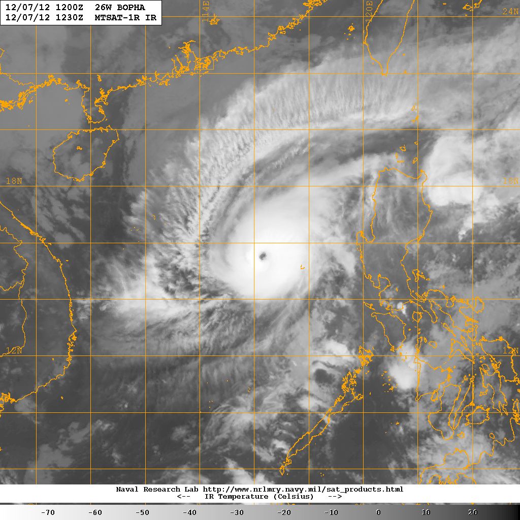
Figures 3a and 3b - BOPHA at peak intensity. Note the very low eyewall cloud top temperatures
圖 3a 及 3b - 寶霞接近巔峰強度時的衛星圖片,留意眼牆雲頂溫度非常低

Figure 4 - BOPHA about to make landfall at Mindanao with full fury
圖 4 - 寶霞即將以巔峰強度在棉蘭老島登陸


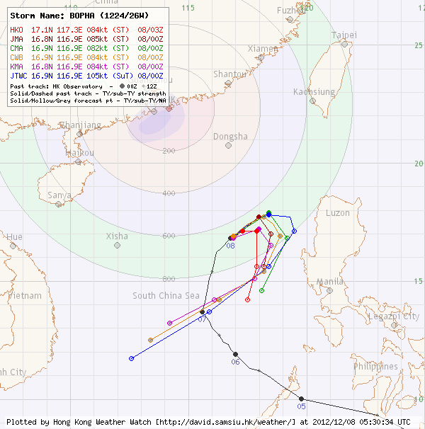
Figures 5a to 5c - Forecast tracks from various official agencies on December 4, 6 and 8
圖 5a 至 5c - 12 月 4、6 及 8 日各官方氣象台預測路徑圖

Figure 6 - Wind shear chart at 8 am on December 8
圖 6 - 12 月 8 日上午 8 時之垂直風切變分佈圖


Figures 7a to 7c - BOPHA weakening rapidly between late December 7 and December 9
圖 7a 至 7c - 寶霞於 12 月 7 日後段至 9 日快速減弱
| Other Data 其他數據 |
Table 1: Track data from HKWW:
表一 : 香港天氣觀測站之路徑資料
| YYMMDDZZ Lat Long Wind 12112512 031N1579E 020 12112518 035N1572E 025 12112600 039N1569E 030 12112606 041N1567E 030 12112612 041N1565E 030 12112618 041N1562E 035 12112700 042N1561E 040 12112706 044N1557E 040 12112712 045N1555E 040 12112718 046N1552E 040 12112800 047N1545E 045 12112806 048N1532E 045 12112812 049N1518E 045 12112818 046N1510E 050 12112900 042N1500E 050 12112906 042N1494E 050 12112912 036N1483E 050 12112918 036N1473E 050 12113000 036N1463E 055 12113006 038N1453E 060 12113012 040N1442E 065 12113018 044N1430E 085 12120100 047N1421E 105 12120106 051N1411E 105 12120112 055N1400E 110 12120118 058N1388E 125 12120200 062N1377E 130 12120206 064N1360E 125 12120212 065N1346E 125 12120218 065N1333E 115 12120300 068N1318E 105 12120306 070N1304E 115 12120312 074N1288E 140 12120318 076N1273E 140 12120400 078N1259E 110 12120406 086N1241E 095 12120412 095N1221E 085 12120418 098N1208E 085 12120500 098N1197E 080 12120506 107N1187E 080 12120512 113N1178E 075 12120518 117N1171E 070 12120600 120N1169E 070 12120606 123N1165E 070 12120612 128N1162E 070 12120618 132N1158E 070 12120700 137N1157E 075 12120706 146N1159E 085 12120712 154N1160E 110 12120718 163N1162E 110 12120800 169N1169E 105 12120806 175N1180E 095 12120812 177N1187E 070 12120818 180N1190E 045 12120900 183N1192E 035 12120906 180N1195E 025 |
Table 2: Track data from JTWC:
表二 : 聯合颱風警報中心之路徑資料
ID Name YYMMDD ZZZZ Lat Long Basin Wind Pres 26W BOPHA 121209 1800 16.9N 119.3E WPAC 20 1007 |
Last Accessed 最近訪問日期: Sat Apr 20 2024 10:38:47 HKT
Last Modified 最近修訂日期: Mon Jul 24 2023
