SONAMU is the seventeenth name in the tropical cyclone name list. It was contributed by North Korea, meaning pine. This name was used in 2000 and 2006.
SONAMU is the seventeenth name in the tropical cyclone name list. It was contributed by North Korea, meaning pine. This name was used in 2000 and 2006.
SONAMU is expected to move SW slowly under the influence of low-level northeasterlies.
清松將受低層東北風影響而向西南緩慢移動。
Intensity
Analysis 強度分析
Current T-number: T2.0/2.5/W0.5/24 HRS
SONAMU's low-level circulation centre becomes completely exposed as convections are constantly sheared away. Under such unfavourable condition, SONAMU will weaken and is expected to dissipate over water by t+36.
現時的 T 號碼: T2.0/2.5/W0.5/24 HRS
清松的低層環流中心完全外露,對流持續被切離。在此較差的大氣環境下,預料清松會繼續減弱,於 36 小時後在海上消散。
Effects on
Hong Kong 對香港的影響
No threat to Hong Kong is expected within the next 72 hours.
清松於未來的 72 小時將不會對香港構成任何影響。
Next Update
下次更新
2013/01/08 (Tue 二), afternoon 下午 (or earlier 或更早)
Other Images
其他圖像
JTWC Track 聯合颱風警報中心路徑圖
JMA Track 日本氣象廳路徑圖
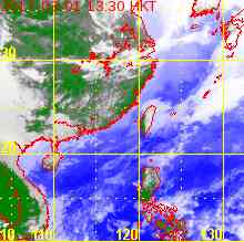
HKO Satellite 香港天文台衛星圖
>
HKO Track 香港天文台路徑圖
Probabilities
of TC Signals from HKO 香港天文台發出 / 取消熱帶氣旋警告信號的機率
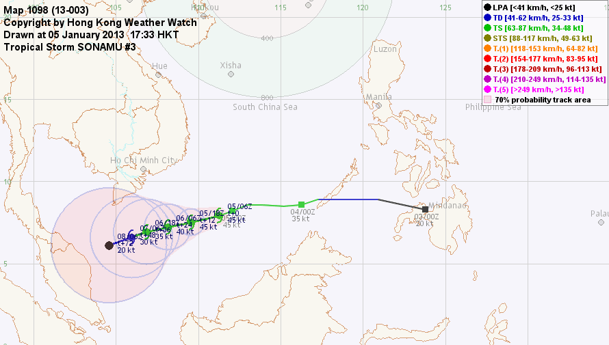
SONAMU has decelerated significantly. At 14 HKT, SONAMU was centred about 520 km (280 NM) SE of Ho Chi Minh City.
清松明顯減速。在下午 2 時,清松集結在胡志明市東南約 520 公里 (280 海里)。
TC
Naming 氣旋命名
SONAMU is the seventeenth name in the tropical cyclone name list. It was contributed by North Korea, meaning pine. This name was used in 2000 and 2006.
SONAMU will move WSW under the influence of low-level northeasterlies.
清松將受低層東北風影響而向西南偏西移動。
Intensity
Analysis 強度分析
Current T-number: T2.5/3.0/W0.5/24 HRS
SONAMU's convections appear looser than yesterday. As it enters a region of higher shear and lower sea temperatures, the storm is expected to weaken and dissipate over water.
現時的 T 號碼: T2.5/3.0/W0.5/24 HRS
清松的對流較昨日鬆散。隨著清松進入較高風切及較低海溫地區,它將逐漸減弱並於海上消散。
Effects on
Hong Kong 對香港的影響
No threat to Hong Kong is expected within the next 72 hours.
清松於未來的 72 小時將不會對香港構成任何影響。
Next Update
下次更新
2013/01/07 (Mon 一), afternoon 下午 (or earlier 或更早)
Other Images
其他圖像
JTWC Track 聯合颱風警報中心路徑圖
JMA Track 日本氣象廳路徑圖
HKO Satellite 香港天文台衛星圖
>
HKO Track 香港天文台路徑圖
Probabilities
of TC Signals from HKO 香港天文台發出 / 取消熱帶氣旋警告信號的機率
SONAMU is the seventeenth name in the tropical cyclone name list. It was contributed by North Korea, meaning pine. This name was used in 2000 and 2006.
SONAMU is expected to move WSW as it is influenced by low-level northeasterlies. The ridge has already been weakened and thus SONAMU should decelerate gradually.
清松將受低層東北風影響而向西南偏西移動。副熱帶高壓脊已經減弱,清松的速度將會減慢。
Intensity
Analysis 強度分析
Current T-number: T3.0/3.0/D0.5/24 HRS
SONAMU's convections are still sheared to the west. The storm is expected to weaken gradually as it enters regions with lower sea temperatures and moderate to high shear.
現時的 T 號碼: T3.0/3.0/D0.5/24 HRS
清松的對流仍然被切離至系統西面。隨著清松進入較低海溫洋面而風切維持於中等至較高水平,它將逐漸減弱。
Effects on
Hong Kong 對香港的影響
No threat to Hong Kong is expected within the next 72 hours.
清松於未來的 72 小時將不會對香港構成任何影響。
Next Update
下次更新
2013/01/06 (Sun 日), afternoon 下午 (or earlier 或更早)
Other Images
其他圖像
JTWC Track 聯合颱風警報中心路徑圖
JMA Track 日本氣象廳路徑圖
HKO Satellite 香港天文台衛星圖
>
HKO Track 香港天文台路徑圖
Probabilities
of TC Signals from HKO 香港天文台發出 / 取消熱帶氣旋警告信號的機率
93W was upgraded into 01W by the JTWC last night. It later intensified into a tropical storm and was named SONAMU. At 14 HKT, SONAMU was centred about 970 km (520 NM) ESE of Ho Chi Minh City.
SONAMU is the seventeenth name in the tropical cyclone name list. It was contributed by North Korea, meaning pine. This name was used in 2000 and 2006.
SONAMU is expected to move WSW as it is influenced by low-level northeasterlies. As the ridge weakens, track speed is expected to decrease.
清松將受低層東北風影響而向西南偏西移動。隨著副熱帶高壓脊減弱,清松的速度將會減慢。
Intensity
Analysis 強度分析
Current T-number: T2.5/2.5/D1.0/24 HRS
SONAMU has intensified but its convections are apparently sheared to the west. The storm is not expected to intensify much before weakening due to lower sea temperatures and persistent shear.
現時的 T 號碼: T2.5/2.5/D1.0/24 HRS
清松略為增強,但對流明顯被切離至系統西面。預料清松增強空間有限,隨後受較低海溫及持續風切影響而減弱。
Effects on
Hong Kong 對香港的影響
No threat to Hong Kong is expected within the next 72 hours.
清松於未來的 72 小時將不會對香港構成任何影響。
Next Update
下次更新
2013/01/05 (Sat 六), afternoon 下午 (or earlier 或更早)
Other Images
其他圖像
JTWC Track 聯合颱風警報中心路徑圖
JMA Track 日本氣象廳路徑圖
HKO Satellite 香港天文台衛星圖
>
HKO Track 香港天文台路徑圖
Probabilities
of TC Signals from HKO 香港天文台發出 / 取消熱帶氣旋警告信號的機率
Tropical disturbance 93W has intensified into the first tropical depression in 2013 in NW Pacific. At 14 HKT, 93W was centred about 630 km (340 NM) S of Manila.
93W is moving W to WNW rapidly under the steering from the subtropical ridge. The storm is expected to move W quickly, followed by a WSW motion as it is expected to be affected by low-level northeasterlies later. Track speed should decrease at that time.
Current T-number: T1.5/1.5/INT OBS
93W's convective wrapping is developing. Some intensification is possible under warm seas, but sea temperatures will decrease as 93W moves west. Shear is likely to impede development as well.
現時的 T 號碼: T1.5/1.5/INT OBS
93W 螺旋雲帶正在發展,預料它在溫暖的海域將能稍為增強,但隨著其西移海溫將下降,且風切亦會阻礙 93W 的發展。
Effects on
Hong Kong 對香港的影響
No threat to Hong Kong is expected within the next 72 hours.
93W 於未來的 72 小時將不會對香港構成任何影響。
Next Update
下次更新
2013/01/04 (Fri 五), afternoon 下午 (or earlier 或更早)
Other Images
其他圖像
JTWC Track 聯合颱風警報中心路徑圖
JMA Track 日本氣象廳路徑圖
HKO Satellite 香港天文台衛星圖
HKO Track 香港天文台路徑圖
Probabilities
of TC Signals from HKO 香港天文台發出 / 取消熱帶氣旋警告信號的機率
 Active Tropical Cyclone(s) 正活躍之熱帶氣旋