TC Watch / 熱帶氣旋 > Latest TC Info 最新熱帶氣旋資訊 [Refresh 更新]

Quick links 快速連結: Current Storm Info 實時氣旋資料 Past Storm Info 過去氣旋資料
HKO Storm Info 天文台之熱帶氣旋資訊 TC Archive 熱帶氣旋資料庫
Official TC Track Info 官方熱帶氣旋路徑資料 Selected TC Review 重要熱帶氣旋回顧
Tracks from Non-Governmental Agencies 民辦網站預測路徑圖 TC Finder 熱帶氣旋尋找工具
Active Tropical Cyclone(s) 正活躍之熱帶氣旋

Current TC Map 即時氣旋資訊Current TC information

Tropical Cyclone Report 熱帶氣旋報告 [Our partner site's TC report 按此看友站的氣旋報告]

1. 05W (BEBINCA 貝碧嘉)

Name of System 系統名稱

TD BEBINCA 熱帶低氣壓 貝碧嘉


JTWC No. / Int'l No. JTWC 編號 / 國際編號 05W / 1305
Bulletin Number 發佈編號 #5 FINAL BULLETIN 最後發佈
Time of Report 報告時間

2013/06/25, 01:00 HKT (06/24 17:00 UTC)

Time of Observation 觀測時間 2013/06/24, 08:00 HKT (00:00 UTC)
Position 位置 20.8°N, 106.4°E
Maximum Gust 最高陣風 40 knots 節 (75 km/h 公里每小時)
1-min. Average Wind Speed 1分鐘平均風速 30 knots 節 (55 km/h 公里每小時)
10-min. Average Wind Speed 10分鐘平均風速 25 knots 節 (45 km/h 公里每小時)
Pressure 氣壓 1000 hPa 百帕斯卡
Past 6-hr Movement 過去6小時移向和移速 N 北 (360°) at 1 knot 節 (2 km/h 公里每小時)
Area(s) affected 受影響地區 Northern Vietnam 越南北部

Forecast Track 預測路徑圖

Forecast Positions 預測位置資料

Tau
時間差
HK Time
香港時間
Lat.
緯度
Long.
經度
Movement
移動速度和方向
1-min Average Strength
一分鐘平均強度
Distance/Bearing from HK
與香港的距離和方位角
t+006/24 (Mon) 08:0020.8°N106.4°ENNE 東北偏北 (020°) 5 km/h30 kt (56 km/h)TD 熱帶低氣壓W 西 820 km
t+1206/24 (Mon) 20:0021.3°N106.6°ENNE 東北偏北 (029°) 5 km/h25 kt (46 km/h)TD 熱帶低氣壓W 西 789 km
t+2406/25 (Tue) 08:0021.8°N106.9°EN/A20 kt (37 km/h)LPA 低壓區W 西 751 km
Overview 總覽

BEBINCA made landfall at northern Vietnam last morning. At 8 am, BEBINCA was centred about 65 km (35 NM) ESE of Hanoi.

貝碧嘉昨早登陸越南北部。在上午 8 時,貝碧嘉集結在河內東南偏東約 65 公里 (35 海里)。

TC Naming 氣旋命名

BEBINCA is the 21st name in the tropical cyclone name list. It was contributed by Macau, and is the name of the Macanese milk pudding. This name was used in 2000 and 2006, with the former occurrence necessitating a #1 Standby Signal.

貝碧嘉為熱帶氣旋名稱列表中第 21 個名字,由澳門提供,為當地一種牛奶布丁的名稱。此名曾於 2000 及 2006 年使用,前者令天文台發出一號戒備信號。

Movement Analysis 路徑分析

BEBINCA is expected to move NNE further inland along the northwestern periphery of the subtropical ridge.

貝碧嘉將沿副熱帶高壓脊西北部向東北偏北移動並深入內陸。

Intensity Analysis 強度分析

Current T-number: N/A
As it moves further inland, BEBINCA is expected to dissipate very soon.

現時的 T 號碼: 不適用
隨著貝碧嘉深入內陸,它將於短期內消散。

Effects on Hong Kong 對香港的影響

N/A 不適用

Next Update 下次更新

This is the final bulletin on BEBINCA.

這是本站對貝碧嘉的最後一次發佈。

Other Images 其他圖像
JTWC Track 聯合颱風警報中心路徑圖
JMA Track 日本氣象廳路徑圖
HKO Satellite 香港天文台衛星圖
HKO Track 香港天文台路徑圖
Probabilities of TC Signals from HKO 香港天文台發出 / 取消熱帶氣旋警告信號的機率
N/A 不適用


Past Bulletins (click on the bulletin no. for the contents) 過往報告 (請按發佈編號顯示內容)

+05W (BEBINCA 貝碧嘉) Bulletin 發佈 #4 (2013/06/23, 12:00 HKT)

Name of System 系統名稱

TS BEBINCA 熱帶風暴 貝碧嘉


JTWC No. / Int'l No. JTWC 編號 / 國際編號 05W / 1305
Bulletin Number 發佈編號 #4
Time of Report 報告時間

2013/06/23, 12:00 HKT (04:00 UTC)

Time of Observation 觀測時間 2013/06/23, 08:00 HKT (00:00 UTC)
Position 位置 19.6°N, 107.2°E
Maximum Gust 最高陣風 55 knots 節 (100 km/h 公里每小時)
1-min. Average Wind Speed 1分鐘平均風速 45 knots 節 (85 km/h 公里每小時)
10-min. Average Wind Speed 10分鐘平均風速 40 knots 節 (75 km/h 公里每小時)
Pressure 氣壓 990 hPa 百帕斯卡
Past 6-hr Movement 過去6小時移向和移速 WNW 西北偏西 (295°) at 7 knots 節 (13 km/h 公里每小時)
Area(s) affected 受影響地區 Gulf of Tonkin 北部灣

Forecast Track 預測路徑圖

Forecast Positions 預測位置資料

Tau
時間差
HK Time
香港時間
Lat.
緯度
Long.
經度
Movement
移動速度和方向
1-min Average Strength
一分鐘平均強度
Distance/Bearing from HK
與香港的距離和方位角
t+0 06/23 (Sun) 08:00 19.6°N 107.2°E NW 西北 (321°) 10 km/h 45 kt (83 km/h) TS 熱帶風暴 WSW 西南偏西 783 km
t+12 06/23 (Sun) 20:00 20.4°N 106.5°E N 北 (353°) 7 km/h 40 kt (74 km/h) TS 熱帶風暴 WSW 西南偏西 821 km
t+24 06/24 (Mon) 08:00 21.2°N 106.4°E N 北 (007°) 7 km/h 30 kt (56 km/h) TD 熱帶低氣壓 W 西 811 km
t+36 06/24 (Mon) 20:00 22.0°N 106.5°E NE 東北 (034°) 12 km/h 25 kt (46 km/h) TD 熱帶低氣壓 W 西 790 km
t+48 06/25 (Tue) 08:00 23.1°N 107.3°E N/A 20 kt (37 km/h) LPA 低壓區 W 西 710 km
Overview 總覽

BEBINCA travelled across Hainan yesterday and is now in the Gulf of Tonkin. At 8 am, BEBINCA was centred about 780 km (420 NM) WSW of Hong Kong.

貝碧嘉昨日橫過海南,現處於北部灣。在上午 8 時,貝碧嘉集結在香港西南偏西約 780 公里 (420 海里)。

TC Naming 氣旋命名

BEBINCA is the 21st name in the tropical cyclone name list. It was contributed by Macau, and is the name of the Macanese milk pudding. This name was used in 2000 and 2006, with the former occurrence necessitating a #1 Standby Signal.

貝碧嘉為熱帶氣旋名稱列表中第 21 個名字,由澳門提供,為當地一種牛奶布丁的名稱。此名曾於 2000 及 2006 年使用,前者令天文台發出一號戒備信號。

Movement Analysis 路徑分析

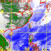
The subtropical ridge is extending at low latitudes. BEBINCA is expected to turn poleward and make landfall at northern Vietnam in the next 12 hours.

副熱帶高壓脊正於低緯度西伸,預料貝碧嘉將轉北移,於未來 12 小時登陸越南北部。

Intensity Analysis 強度分析

Current T-number: T2.5/2.5/S0.0/24 HRS
BEBINCA's strongest convections are still displaced to its southwest. The storm will weaken gradually due to land interaction, and as it makes landfall it will degenerate into an area of low pressure.

現時的 T 號碼: T2.5/2.5/S0.0/24 HRS
貝碧嘉最強的對流集中在其西南部。受陸地影響預料貝碧嘉將逐漸減弱,登陸後進一步減弱為低壓區。

Effects on Hong Kong 對香港的影響

N/A 不適用

Next Update 下次更新

2013/06/24 (Mon 一) nighttime to 晚間至 2013/06/25 (Tue 二) morning 清晨 (or earlier 或更早)

Other Images 其他圖像
JTWC Track 聯合颱風警報中心路徑圖
JMA Track 日本氣象廳路徑圖
HKO Satellite 香港天文台衛星圖
HKO Track 香港天文台路徑圖
Probabilities of TC Signals from HKO 香港天文台發出 / 取消熱帶氣旋警告信號的機率
N/A 不適用

+05W (BEBINCA 貝碧嘉) Bulletin 發佈 #3 (2013/06/22, 10:45 HKT)

Name of System 系統名稱

TS BEBINCA 熱帶風暴 貝碧嘉


JTWC No. / Int'l No. JTWC 編號 / 國際編號 05W / 1305
Bulletin Number 發佈編號 #3
Time of Report 報告時間

2013/06/22, 10:45 HKT (02:45 UTC)

Time of Observation 觀測時間 2013/06/22, 08:00 HKT (00:00 UTC)
Position 位置 19.5°N, 111.7°E
Maximum Gust 最高陣風 55 knots 節 (100 km/h 公里每小時)
1-min. Average Wind Speed 1分鐘平均風速 45 knots 節 (85 km/h 公里每小時)
10-min. Average Wind Speed 10分鐘平均風速 40 knots 節 (75 km/h 公里每小時)
Pressure 氣壓 990 hPa 百帕斯卡
Past 6-hr Movement 過去6小時移向和移速 W 西 (279°) at 12 knots 節 (23 km/h 公里每小時)
Area(s) affected 受影響地區 Hainan Island 海南島

Forecast Track 預測路徑圖

Forecast Positions 預測位置資料

Tau
時間差
HK Time
香港時間
Lat.
緯度
Long.
經度
Movement
移動速度和方向
1-min Average Strength
一分鐘平均強度
Distance/Bearing from HK
與香港的距離和方位角
t+0 06/22 (Sat) 08:00 19.5°N 111.7°E W 西 (279°) 19 km/h 45 kt (83 km/h) TS 熱帶風暴 SW 西南 403 km
t+12 06/22 (Sat) 20:00 19.8°N 109.6°E WNW 西北偏西 (285°) 14 km/h 40 kt (74 km/h) TS 熱帶風暴 WSW 西南偏西 549 km
t+24 06/23 (Sun) 08:00 20.2°N 108.0°E NW 西北 (317°) 11 km/h 40 kt (74 km/h) TS 熱帶風暴 WSW 西南偏西 680 km
t+36 06/23 (Sun) 20:00 21.1°N 107.1°E NNW 西北偏北 (341°) 11 km/h 35 kt (65 km/h) TS 熱帶風暴 W 西 742 km
t+48 06/24 (Mon) 08:00 22.2°N 106.7°E N 北 (006°) 8 km/h 25 kt (46 km/h) TD 熱帶低氣壓 W 西 768 km
t+72 06/25 (Tue) 08:00 23.9°N 106.9°E N/A 20 kt (37 km/h) LPA 低壓區 WNW 西北偏西 764 km
Overview 總覽

BEBINCA is moving west towards Hainan Island. At 8 am, BEBINCA was centred about 400 km (220 NM) SW of Hong Kong. The #3 Strong Wind Signal was in force from 8:20 pm last night to 9:10 am today, and has since then been replaced by the #1 Standby Signal. UPDATE AT 11:30 AM: All tropical cyclone signals were lifted at 11:15 am.

貝碧嘉向西移動,趨向海南島一帶。在上午 8 時,貝碧嘉集結在香港西南約 400 公里 (220 海里)。三號強風信號於昨晚 8 時 20 分至今早 9 時 10 分生效,其後天文台改發一號戒備信號。上午 11 時 30 分更新:所有熱帶氣旋警告信號已於上午 11 時 15 分解除。

TC Naming 氣旋命名

BEBINCA is the 21st name in the tropical cyclone name list. It was contributed by Macau, and is the name of the Macanese milk pudding. This name was used in 2000 and 2006, with the former occurrence necessitating a #1 Standby Signal.

貝碧嘉為熱帶氣旋名稱列表中第 21 個名字,由澳門提供,為當地一種牛奶布丁的名稱。此名曾於 2000 及 2006 年使用,前者令天文台發出一號戒備信號。

Movement Analysis 路徑分析

BEBINCA will move west in the next 24 hours under the influence of a ridge in China. The subtropical ridge may extend at low latitudes later on (and retreating at higher latitudes), pushing the storm towards the north.

受於中國的高壓脊影響,貝碧嘉將於未來 24 小時向西移動。其後副熱帶高壓脊可能於低緯度西伸但高緯度東退,令貝碧嘉轉向偏北移動。

Intensity Analysis 強度分析

Current T-number: T2.5/2.5/S0.0/18 HRS
BEBINCA's intensity has not changed much in the past 12 hours. The storm is expected to weaken as it crosses Hainan, and further after it makes landfall at northern Vietnam.

現時的 T 號碼: T2.5/2.5/S0.0/18 HRS
貝碧嘉的強度於過去 12 小時無大變化。預料風暴橫過海南時會減弱,登陸越南北部後減弱速度加快。

Effects on Hong Kong 對香港的影響

During BEBINCA's passage, strong force winds were observed at some areas in Hong Kong. Winds will gradually subside today, but the weather will remain unstable for the rest of today and tomorrow.

貝碧嘉掠過期間,本港部分地區錄得強風。預料風勢將於今天緩和,但今明兩天的天氣仍不穩定。

Next Update 下次更新

2013/06/23 (Sun 日), afternoon 下午 (or earlier 或更早)

Other Images 其他圖像
JTWC Track 聯合颱風警報中心路徑圖
JMA Track 日本氣象廳路徑圖
HKO Satellite 香港天文台衛星圖
HKO Track 香港天文台路徑圖
Probabilities of TC Signals from HKO 香港天文台發出 / 取消熱帶氣旋警告信號的機率
Signal 信號
t+12
t+24
t+36
t+48
t+60
t+72
Standby 戒備 #1 (Cnl. 取消)
High 高
Very High 極高
Very High 極高
Very High 極高
Very High 極高
Very High 極高
Strong Wind 強風 #3
Gale/Storm 烈或暴風 #8
G/S Incr. 烈或暴風增強 #9
Hurricane 颶風 #10

Notes 註:
1) For issuance, "Signal" column represents having issued that signal or above. 有關發出機率,首欄指已發出該信號或更高信號。
2) "Low" = Probability from 5 to 20 per cent; "Medium" = 20 to 50%; "High" = 50 to 80%; "V High" = 80% or above.
"低" = 5% - 20% 的機率; "中等" = 20 - 50%; "高" = 50 - 80%; "極高" = 80% 或以上。

+05W (BEBINCA 貝碧嘉) Bulletin 發佈 #2 (2013/06/21, 16:30 HKT)

Name of System 系統名稱

TS BEBINCA 熱帶風暴 貝碧嘉


JTWC No. / Int'l No. JTWC 編號 / 國際編號 05W / 1305
Bulletin Number 發佈編號 #2
Time of Report 報告時間

2013/06/21, 16:30 HKT (08:30 UTC)

Time of Observation 觀測時間 2013/06/21, 14:00 HKT (06:00 UTC)
Position 位置 18.5°N, 115.3°E
Maximum Gust 最高陣風 50 knots 節 (95 km/h 公里每小時)
1-min. Average Wind Speed 1分鐘平均風速 40 knots 節 (75 km/h 公里每小時)
10-min. Average Wind Speed 10分鐘平均風速 35 knots 節 (65 km/h 公里每小時)
Pressure 氣壓 995 hPa 百帕斯卡
Past 6-hr Movement 過去6小時移向和移速 WNW 西北偏西 (300°) at 10 knots 節 (18 km/h 公里每小時)
Area(s) affected 受影響地區 Northern South China Sea 南海北部

Forecast Track 預測路徑圖

Forecast Positions 預測位置資料

Tau
時間差
HK Time
香港時間
Lat.
緯度
Long.
經度
Movement
移動速度和方向
1-min Average Strength
一分鐘平均強度
Distance/Bearing from HK
與香港的距離和方位角
t+0 06/21 (Fri) 14:00 18.5°N 115.3°E WNW 西北偏西 (301°) 18 km/h 40 kt (74 km/h) TS 熱帶風暴 SSE 東南偏南 438 km
t+12 06/22 (Sat) 02:00 19.5°N 113.5°E WNW 西北偏西 (290°) 19 km/h 40 kt (74 km/h) TS 熱帶風暴 SSW 西南偏南 319 km
t+24 06/22 (Sat) 14:00 20.2°N 111.4°E WNW 西北偏西 (287°) 20 km/h 45 kt (83 km/h) TS 熱帶風暴 SW 西南 370 km
t+36 06/23 (Sun) 02:00 20.8°N 109.2°E WNW 西北偏西 (290°) 19 km/h 45 kt (83 km/h) TS 熱帶風暴 WSW 西南偏西 540 km
t+48 06/23 (Sun) 14:00 21.5°N 107.1°E NW 西北 (304°) 11 km/h 40 kt (74 km/h) TS 熱帶風暴 W 西 734 km
t+72 06/24 (Mon) 14:00 22.8°N 105.0°E N/A 20 kt (37 km/h) LPA 低壓區 W 西 943 km
Overview 總覽

94W was given the number 05W by the JTWC. It has intensified into a tropical storm and was named BEBINCA by the JMA. At 2 pm, BEBINCA was centred about 440 km (240 NM) SSE of Hong Kong. The #1 Standby Signal was issued at 7:40 am today.

94W 被聯合颱風警報中心給予編號 05W,該系統並增強為熱帶風暴,被日本氣象廳命名為貝碧嘉。在下午 2 時,貝碧嘉集結在香港東南偏南約 440 公里 (240 海里)。天文台於今早 7 時 40 分發出一號戒備信號。

TC Naming 氣旋命名

BEBINCA is the 21st name in the tropical cyclone name list. It was contributed by Macau, and is the name of the Macanese milk pudding. This name was used in 2000 and 2006, with the former occurrence necessitating a #1 Standby Signal.

貝碧嘉為熱帶氣旋名稱列表中第 21 個名字,由澳門提供,為當地一種牛奶布丁的名稱。此名曾於 2000 及 2006 年使用,前者令天文台發出一號戒備信號。

Movement Analysis 路徑分析

BEBINCA has turned to the WNW under the influence of the subtropical ridge. That and another ridge in central China will continue to push BEBINCA towards the WNW towards Leizhou Peninsula. Some models predict that the continental ridge will weaken at later taus, leading to a slowdown and poleward turn.

貝碧嘉受副熱帶高壓脊的影響已轉向西北偏西移動。在它及於中國中部的大陸高壓脊之推動下預料貝碧嘉將繼續向西北偏西移,趨向雷州半島一帶。部分模式預料大陸高壓會於預測後期減弱,令貝碧嘉速度減慢並轉北。

Intensity Analysis 強度分析

Current T-number: T2.5/2.5/D0.5/24 HRS
BEBINCA's low-level circulation is intact but exposed due to moderate shear. In decent sea temperatures (above 28 degrees) the storm may intensify slightly before making landfall, and rapid weakening is expected afterwards.

現時的 T 號碼: T2.5/2.5/D0.5/24 HRS
貝碧嘉的低層環流完整但因垂直風切變不低而較為外露。在良好海溫 (28 度以上) 的環境下預料貝碧嘉可於登陸前稍為增強,其後快速減弱。

Effects on Hong Kong 對香港的影響

BEBINCA's outer rainbands will soon affect Hong Kong. Winds will strengthen from the northeast, veering to southeast tomorrow. The storm is expected to be closest to the territory early tomorrow. Squally showers will persist on Sunday.

貝碧嘉的外圍雨帶即將影響本港。東北風將會增強,並於明天順轉為東南風。預測貝碧嘉將於明日早段最接近香港,但狂風驟雨將於周日持續。

Next Update 下次更新

2013/06/22 (Sat 六), afternoon 下午 (or earlier 或更早)

Other Images 其他圖像
JTWC Track 聯合颱風警報中心路徑圖
JMA Track 日本氣象廳路徑圖
HKO Satellite 香港天文台衛星圖
HKO Track 香港天文台路徑圖
Probabilities of TC Signals from HKO 香港天文台發出 / 取消熱帶氣旋警告信號的機率
Signal 信號
t+12
t+24
t+36
t+48
t+60
t+72
Standby 戒備 #1 (Cnl. 取消)
Medium 中等
High 高
Very High 極高
Very High 極高
Strong Wind 強風 #3
High 高
High 高
Low 低
Gale/Storm 烈或暴風 #8
Low 低
G/S Incr. 烈或暴風增強 #9
Hurricane 颶風 #10

Notes 註:
1) For issuance, "Signal" column represents having issued that signal or above. 有關發出機率,首欄指已發出該信號或更高信號。
2) "Low" = Probability from 5 to 20 per cent; "Medium" = 20 to 50%; "High" = 50 to 80%; "V High" = 80% or above.
"低" = 5% - 20% 的機率; "中等" = 20 - 50%; "高" = 50 - 80%; "極高" = 80% 或以上。

+94W Bulletin 發佈 #1 (2013/06/20, 16:45 HKT)

Name of System 系統名稱

TD 94W 熱帶低氣壓 94W


JTWC No. / Int'l No. JTWC 編號 / 國際編號 94W / ----
Bulletin Number 發佈編號 #1
Time of Report 報告時間

2013/06/20, 16:45 HKT (08:45 UTC)

Time of Observation 觀測時間 2013/06/20, 14:00 HKT (06:00 UTC)
Position 位置 16.2°N, 117.5°E
Maximum Gust 最高陣風 40 knots 節 (75 km/h 公里每小時)
1-min. Average Wind Speed 1分鐘平均風速 30 knots 節 (55 km/h 公里每小時)
10-min. Average Wind Speed 10分鐘平均風速 25 knots 節 (45 km/h 公里每小時)
Pressure 氣壓 998 hPa 百帕斯卡
Past 6-hr Movement 過去6小時移向和移速 NE 東北 (044°) at 7 knots 節 (13 km/h 公里每小時)
Area(s) affected 受影響地區 Central South China Sea 南海中部

Forecast Track 預測路徑圖

Forecast Positions 預測位置資料

Tau
時間差
HK Time
香港時間
Lat.
緯度
Long.
經度
Movement
移動速度和方向
1-min Average Strength
一分鐘平均強度
Distance/Bearing from HK
與香港的距離和方位角
t+0 06/20 (Thu) 14:00 16.2°N 117.5°E N 北 (008°) 13 km/h 30 kt (56 km/h) TD 熱帶低氣壓 SSE 東南偏南 762 km
t+12 06/21 (Fri) 02:00 17.6°N 117.7°E NNW 西北偏北 (336°) 13 km/h 35 kt (65 km/h) TS 熱帶風暴 SE 東南 639 km
t+24 06/21 (Fri) 14:00 18.9°N 117.1°E WNW 西北偏西 (303°) 14 km/h 40 kt (74 km/h) TS 熱帶風暴 SE 東南 485 km
t+36 06/22 (Sat) 02:00 19.7°N 115.8°E WNW 西北偏西 (291°) 16 km/h 40 kt (74 km/h) TS 熱帶風暴 SSE 東南偏南 335 km
t+48 06/22 (Sat) 14:00 20.3°N 114.1°E WNW 西北偏西 (292°) 18 km/h 45 kt (83 km/h) TS 熱帶風暴 S 南 222 km
t+72 06/23 (Sun) 14:00 21.7°N 110.3°E N/A 40 kt (74 km/h) TS 熱帶風暴 W 西 404 km
Overview 總覽

Tropical disturbance 94W west of the Philippines has intensified into a tropical depression. At 14 HKT, 94W was centred about 760 km (410 NM) SSE of Hong Kong.

在菲律賓以西的熱帶擾動 94W 已增強為熱帶低氣壓。在下午 2 時,94W 集結在香港東南偏南約 760 公里 (410 海里)。

TC Naming 氣旋命名

N/A 不適用

Movement Analysis 路徑分析

94W is moving N to NNE along the western periphery of the subtropical ridge and the low-level southwesterly airstream. After the passage of LEEPI the ridge is expected to extend westwards, and together with the presence of a ridge over eastern China 94W will turn to the NW or WNW in 24 to 36 hours' time.

94W 正沿副熱帶高壓脊西端及低層西南氣流向北至東北偏北移動。隨著麗琵移離副高將得以西伸,加上於中國東部的脊場的影響,94W 將於 24 至 36 小時後轉向西北或西北偏西移動。

Intensity Analysis 強度分析

Current T-number: T2.0/2.0/INT OBS
Abundant moisture is feeding into the system from the south. Shear is moderate near 94W but rather high in the rest of the South China Sea. 94W is expected to consolidate and intensify into a tropical storm soon.

現時的 T 號碼: T2.0/2.0/INT OBS
充足的濕潤空氣由系統的南部進入。94W 附近垂直風切變中等,但南海其餘地區風切較高。預料 94W 會逐步整固,短期內增強為熱帶風暴。

Effects on Hong Kong 對香港的影響

94W's subsidence is bringing very hot weather to the territory. As the storm intensifies and draws near, northeasterly winds will strengthen tomorrow and are expected to veer to southeast over the weekend. 94W's rainbands are likely to produce squally showers to Hong Kong on Saturday and Sunday.

94W 的下沉氣流正為本港帶來酷熱的天氣。隨著 94W 增強並靠近,東北風將於明天增強,預計會於周末期間順轉至東南風。94W 的雨帶可能於周六及周日為本港帶來狂風驟雨。

Next Update 下次更新

2013/06/21 (Fri 五), afternoon 下午 (or earlier 或更早)

Other Images 其他圖像
JTWC Track 聯合颱風警報中心路徑圖
JMA Track 日本氣象廳路徑圖
HKO Satellite 香港天文台衛星圖
HKO Track 香港天文台路徑圖
Probabilities of TC Signals from HKO 香港天文台發出 / 取消熱帶氣旋警告信號的機率
Signal 信號
t+12
t+24
t+36
t+48
t+60
t+72
Standby 戒備 #1
Medium 中等
High 高
Very High 極高
Very High 極高
High 高
Medium 中等
Strong Wind 強風 #3
Low 低
High 高
Medium 中等
Low 低
Gale/Storm 烈或暴風 #8
Low 低
Low 低
G/S Incr. 烈或暴風增強 #9
Hurricane 颶風 #10

Notes 註:
1) For issuance, "Signal" column represents having issued that signal or above. 有關發出機率,首欄指已發出該信號或更高信號。
2) "Low" = Probability from 5 to 20 per cent; "Medium" = 20 to 50%; "High" = 50 to 80%; "V High" = 80% or above.
"低" = 5% - 20% 的機率; "中等" = 20 - 50%; "高" = 50 - 80%; "極高" = 80% 或以上。

Track Data from HKWW 本站之路徑資料

YYMMDDZZ Lat Long Wind
13062000 157N1170E 025
13062006 162N1175E 030
13062012 168N1175E 030
13062018 174N1172E 035
13062100 180N1162E 035
13062106 185N1153E 040
13062112 191N1145E 045
13062118 193N1130E 045
13062200 195N1117E 045
13062206 191N1101E 045
13062212 191N1088E 040
13062218 193N1079E 040
13062300 196N1072E 045
13062306 199N1069E 045
13062312 204N1064E 040
13062318 207N1064E 035
13062400 208N1064E 030