TC Watch / 熱帶氣旋
> Latest TC Info 最新熱帶氣旋資訊 [Refresh 更新 ]
Current
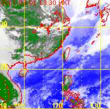
TC Map 即時氣旋資訊
2. 18W
Name of System 系統名稱
TD 18W 熱帶低氣壓 18W
JTWC No. / Int'l No. JTWC
編號 / 國際編號
18W / ----
Bulletin Number 發佈編號
#2 FINAL BULLETIN 最後發佈
Time of
Report 報告時間
2013/09/19, 08:15 HKT (00:15 UTC)
Time of
Observation 觀測時間
2013/09/19,
08:00 HKT (00:00 UTC)
Position 位置
16.3°N, 107.8°E
Maximum Gust 最高陣風
35 knots 節 (65 km/h 公里每小時)
1-min. Average Wind Speed 1分鐘平均風速
25 knots 節 (45 km/h 公里每小時)
10-min. Average Wind Speed 10分鐘平均風速
25 knots 節 (45 km/h 公里每小時)
Pressure 氣壓
1000 hPa 百帕斯卡
Past 6-hr Movement 過去6小時移向和移速
W 西 (262°) at 7 knots 節 (13 km/h 公里每小時)
Area(s) affected 受影響地區
Central Vietnam 越南中部
Forecast
Track 預測路徑圖
Forecast
Positions 預測位置資料
Tau HK Time Lat. Long. Movement 1-min Average Strength Distance/Bearing from HK t+0 09/19 (Thu) 08:00 16.3°N 107.8°E WSW 西南偏西 (258°) 14 km/h 25 kt (46 km/h) TD 熱帶低氣壓 SW 西南 944 km t+12 09/19 (Thu) 20:00 16.0°N 106.3°E N/A 20 kt (37 km/h) LPA 低壓區 SW 西南 1082 km
Overview
總覽
18W has made landfall in central Vietnam. At 8 am, 18W was centred about 55 km (30 NM) WNW of Da Nang.
18W 已於越南中部登陸。在上午 8 時,18W 集結在峴港西北偏西約 55 公里 (30 海里)。
TC
Naming 氣旋命名
N/A 不適用
Movement
Analysis 路徑分析
18W is expected to track W to WSW along the southern periphery of the subtropical ridge.
18W 將沿副熱帶高壓脊南部向西或西南偏西移動。
Intensity
Analysis 強度分析
Current T-number: N/A
現時的 T 號碼: 不適用
Effects on
Hong Kong 對香港的影響
No threat to Hong Kong is expected within the next 72 hours.
預料 18W 於未來的 72 小時將不會對香港構成任何影響。
Next Update
下次更新
This is the final bulletin on 18W.
這是本站對 18W 的最後一次發佈。
Other Images
其他圖像
Probabilities
of TC Signals from HKO 香港天文台發出 / 取消熱帶氣旋警告信號的機率
N/A 不適用
Name of System 系統名稱
TD 18W 熱帶低氣壓 18W
JTWC No. / Int'l No. JTWC
編號 / 國際編號
18W / ----
Bulletin Number 發佈編號
#1
Time of
Report 報告時間
2013/09/18, 15:45 HKT (07:45 UTC)
Time of
Observation 觀測時間
2013/09/18,
14:00 HKT (06:00 UTC)
Position 位置
16.4°N, 110.4°E
Maximum Gust 最高陣風
40 knots 節 (75 km/h 公里每小時)
1-min. Average Wind Speed 1分鐘平均風速
30 knots 節 (55 km/h 公里每小時)
10-min. Average Wind Speed 10分鐘平均風速
25 knots 節 (45 km/h 公里每小時)
Pressure 氣壓
998 hPa 百帕斯卡
Past 6-hr Movement 過去6小時移向和移速
WNW 西北偏西 (293°) at 5 knots 節 (10 km/h 公里每小時)
Area(s) affected 受影響地區
W South China Sea 南海西部
Forecast
Track 預測路徑圖
Forecast
Positions 預測位置資料
Tau
HK Time
Lat.
Long.
Movement
1-min Average Strength
Distance/Bearing from HK
t+0
09/18 (Wed) 14:00
16.4°N
110.4°E
W 西 (281°) 10 km/h
30 kt (56 km/h)
TD 熱帶低氣壓
SSW 西南偏南 765 km
t+12
09/19 (Thu) 02:00
16.6°N
109.3°E
W 西 (270°) 12 km/h
30 kt (56 km/h)
TD 熱帶低氣壓
SW 西南 813 km
t+24
09/19 (Thu) 14:00
16.6°N
107.9°E
W 西 (266°) 12 km/h
25 kt (46 km/h)
TD 熱帶低氣壓
SW 西南 912 km
t+36
09/20 (Fri) 02:00
16.5°N
106.6°E
N/A
20 kt (37 km/h)
LPA 低壓區
SW 西南 1022 km
Overview
總覽
Tropical disturbance 90W in the South China Sea has intensified into tropical depression 18W. At 2 pm, 18W was centred about 230 km (130 NM) E of Da Nang.
於南海的熱帶擾動 90W 已增強為熱帶低氣壓 18W。在下午 2 時,18W 集結在峴港以東約 230 公里 (130 海里)。
TC
Naming 氣旋命名
N/A 不適用
Movement
Analysis 路徑分析
18W is expected to track W along the southern periphery of the subtropical ridge, making landfall in central Vietnam tomorrow.
18W 將沿副熱帶高壓脊南部向西移動,於明日登陸越南中部。
Intensity
Analysis 強度分析
Current T-number: T2.0/2.0/INT OBS
現時的 T 號碼: T2.0/2.0/INT OBS
Effects on
Hong Kong 對香港的影響
No threat to Hong Kong is expected within the next 72 hours.
預料 18W 於未來的 72 小時將不會對香港構成任何影響。
Next Update
下次更新
2013/09/19 (Thu 四), afternoon 下午 (or earlier 或更早)
Other Images
其他圖像
Probabilities
of TC Signals from HKO 香港天文台發出 / 取消熱帶氣旋警告信號的機率
N/A 不適用
YYMMDDZZ Lat Long Wind
 Active Tropical Cyclone(s) 正活躍之熱帶氣旋