WUTIP briefly intensified into a category 2 typhoon yesterday but has weakened since then. At 8 am, WUTIP was centred about 130 km (70 NM) NNE of Da Nang.
WUTIP is the 35th name in the tropical cyclone name list. It was contributed by Macau, meaning butterfly. This name was used in 2001 and 2007.
蝴蝶為熱帶氣旋名稱列表中第 35 個名字,由澳門提供。此名曾於 2001 及 2007 年使用。
Movement
Analysis 路徑分析
The subtropical ridge has extended westwards and WUTIP is acceleraing towards W/WNW. The storm will continue to move W/WNW and make landfall before t+12.
副熱帶高壓脊已經西伸,蝴蝶加速向西至西北偏西移動。預計此路徑將維持,風暴會於 t+12 前登陸。
Intensity
Analysis 強度分析
Current T-number: T4.0/4.5/W0.5/24 HRS
WUTIP's eye enlarged but convections remain compact. As WUTIP makes landfall at Vietnam, it will move inland and weaken rapidly..
現時的 T 號碼: T4.0/4.5/W0.5/24 HRS
蝴蝶的風眼擴大但對流仍然緊密。隨著蝴蝶登陸越南,它將移入內陸並快速減弱。
Effects on
Hong Kong 對香港的影響
Due to the combined effect of the northeast monsoon and WUTIP, strong northeasterly winds and rain will persist today.
受東北季候風及蝴蝶的共同影響,本港今天將繼續吹東北強風並有雨。
Next Update
下次更新
2013/10/01 (Tue 二), afternoon 下午 (or earlier 或更早)
Other Images
其他圖像
JTWC Track 聯合颱風警報中心路徑圖
JMA Track 日本氣象廳路徑圖
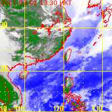
HKO Satellite 香港天文台衛星圖
HKO Track 香港天文台路徑圖
Probabilities
of TC Signals from HKO 香港天文台發出 / 取消熱帶氣旋警告信號的機率
WUTIP has intensified into a typhoon. At 8 am, WUTIP was centred about 640 km (340 NM) SSW of Hong Kong.
蝴蝶已增強為颱風。在上午 8 時,蝴蝶集結在香港西南偏南約 640 公里 (340 海里)。
TC
Naming 氣旋命名
WUTIP is the 35th name in the tropical cyclone name list. It was contributed by Macau, meaning butterfly. This name was used in 2001 and 2007.
蝴蝶為熱帶氣旋名稱列表中第 35 個名字,由澳門提供。此名曾於 2001 及 2007 年使用。
Movement
Analysis 路徑分析
The subtropical ridge is expected to extend westwards after t+24, allowing WUTIP to accelerate towards the west. The storm is expected to make landfall at central Vietnam between t+36 and t+48.
Current T-number: T4.5/4.5/D1.0/24 HRS
WUTIP has developed a central dense overcast and a clear eye is emerging. The storm should continue to intensify in the next 24 hours in warm seas with very good divergence aloft, impacting Vietnam as a significant typhoon.
現時的 T 號碼: T4.5/4.5/D1.0/24 HRS
蝴蝶發展出中心密集雲區,風眼逐漸變得清晰。在高海溫及輻散較好的環境下,預料風暴將於未來 24 小時繼續增強,並會以較高颱風強度登陸越南。
Effects on
Hong Kong 對香港的影響
WUTIP will enhance the pressure gradient in northern South China Sea leading to stronger northeasterly winds in Hong Kong today and tomorrow. The Cuming effect associated with WUTIP will lead to rainy weather.
蝴蝶會增加南海北部的氣壓梯度,本港今明兩天東北風將較強。受奎明效應影響,香港將會有雨。
Next Update
下次更新
2013/09/30 (Mon 一), afternoon 下午 (or earlier 或更早)
Other Images
其他圖像
JTWC Track 聯合颱風警報中心路徑圖
JMA Track 日本氣象廳路徑圖
HKO Satellite 香港天文台衛星圖
HKO Track 香港天文台路徑圖
Probabilities
of TC Signals from HKO 香港天文台發出 / 取消熱帶氣旋警告信號的機率
WUTIP is the 35th name in the tropical cyclone name list. It was contributed by Macau, meaning butterfly. This name was used in 2001 and 2007.
蝴蝶為熱帶氣旋名稱列表中第 35 個名字,由澳門提供。此名曾於 2001 及 2007 年使用。
Movement
Analysis 路徑分析
WUTIP is now moving slowly due to competing steering influence from the subtropical ridge to the east and a high pressure cell to the west. The storm is expected to turn W and then WNW gradually as the ridge re-strengthens and extends westwards later.
Current T-number: T3.5/3.5/D1.5/24 HRS
WUTIP has strengthened significantly over the past 24 hours and an eye can be seen forming. The storm should continue to intensify in warm seas with very good divergence aloft, impacting Vietnam as a typhoon between t+48 and t+72.
WUTIP may enhance the pressure gradient in northern South China Sea leading to stronger northeasterly winds in Hong Kong. There is a chance that WUTIP enters the Cuming area at later taus, leading to rainy weather in Hong Kong.
蝴蝶會增加南海北部的氣壓梯度,本港東北風會增強。蝴蝶於預測後期可能進入奎明範圍,香港將會有雨。
Next Update
下次更新
2013/09/29 (Sun 日), afternoon 下午 (or earlier 或更早)
Other Images
其他圖像
JTWC Track 聯合颱風警報中心路徑圖
JMA Track 日本氣象廳路徑圖
HKO Satellite 香港天文台衛星圖
HKO Track 香港天文台路徑圖
Probabilities
of TC Signals from HKO 香港天文台發出 / 取消熱帶氣旋警告信號的機率
Signal 信號
t+12
t+24
t+36
t+48
t+60
t+72
Standby 戒備 #1
Low 低
Low 低
Strong Wind 強風 #3
Gale/Storm 烈或暴風 #8
G/S Incr. 烈或暴風增強 #9
Hurricane 颶風 #10
Notes 註:
1) For issuance, "Signal" column represents having issued that signal or above. 有關發出機率,首欄指已發出該信號或更高信號。
2) "Low" = Probability from 5 to 20 per cent; "Medium" = 20 to 50%; "High" = 50 to 80%; "V High" = 80% or above.
"低" = 5% - 20% 的機率; "中等" = 20 - 50%; "高" = 50 - 80%; "極高" = 80% 或以上。
A tropical disturbance west of the Philippines has intensified into tropical depression 20W. At 8 am, 20W was centred about 790 km (430 NM) SSE of Hong Kong.
20W is expected to turn W and dip south near t+24 to t+48 due to the shape of the subtropical ridge. The ridge is forecast to weaken later and reorients, allowing the storm to turn WNW again.
Current T-number: T2.0/2.0/INT OBS
20W should intensify steadily in a low shear environment with high sea temperatures.
現時的 T 號碼: T2.0/2.0/INT OBS
20W 將於低垂直風切變及高海溫的環境下穩定增強。
Effects on
Hong Kong 對香港的影響
20W may enhance the pressure gradient in northern South China Sea leading to stronger winds in Hong Kong. There is a chance that 20W enters the Cuming area at later taus, leading to rainy weather in Hong Kong.
 Active Tropical Cyclone(s) 正活躍之熱帶氣旋