NARI has made landfall in central Vietnam. At 8 am, NARI was centred about 25 km (15 NM) WSW of Da Nang.
百合已於越南中部登陸。在上午 8 時,百合集結在峴港西南偏西約 25 公里 (15 海里)。
TC
Naming 氣旋命名
NARI is the 39th name in the tropical cyclone name list. It was contributed by South Korea, meaning lily. This name was used in 2001 and 2007, with the former necessitating the #3 Strong Wind Signal.
NARI is the 39th name in the tropical cyclone name list. It was contributed by South Korea, meaning lily. This name was used in 2001 and 2007, with the former necessitating the #3 Strong Wind Signal.
A ridge extension and the northeast monsoon will together bring NARI westwards towards central Vietnam.
高壓脊的延伸及東北季候風將帶動百合西移,趨向越南中部。
Intensity
Analysis 強度分析
Current T-number: T5.0/5.0/S0.0/24 HRS
NARI's intensity remains stable. The storm should maintain strength in the next 12 hours, and weaken thereafter as land interaction sets in. Rapid weakening is expected after landfall.
現時的 T 號碼: T5.0/5.0/S0.0/24 HRS
百合的強度大致維持。預料風暴會於未來 12 小時維持強度,其後受陸地影響而減弱。百合減弱速度會於登陸後加快。
Effects on
Hong Kong 對香港的影響
Due to the combined effects of the northeast monsoon and NARI, stronger northeasterly winds are observed in Hong Kong with rain. The weather will improve on Wednesday.
受東北季候風及百合的共同影響,本港東北風會較強並有雨。天氣會於周三改善。
Next Update
下次更新
2013/10/15 (Tue 二), afternoon 下午 (or earlier 或更早)
Other Images
其他圖像
JTWC Track 聯合颱風警報中心路徑圖
JMA Track 日本氣象廳路徑圖
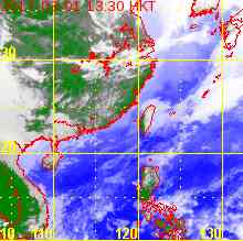
HKO Satellite 香港天文台衛星圖
HKO Track 香港天文台路徑圖
Probabilities
of TC Signals from HKO 香港天文台發出 / 取消熱帶氣旋警告信號的機率
NARI moves west steadily across South China Sea. At 8 am, NARI was centred about 780 km (420 NM) S of Hong Kong.
百合穩定地西移,橫過南海。在上午 8 時,百合集結在香港以南約 780 公里 (420 海里)。
TC
Naming 氣旋命名
NARI is the 39th name in the tropical cyclone name list. It was contributed by South Korea, meaning lily. This name was used in 2001 and 2007, with the former necessitating the #3 Strong Wind Signal.
The steering ridge has weakened slightly, but is sill strong enough for NARI to maintain a westward movement. It is expected NARI will move W or WNW towards central Vietnam.
帶動百合西移的脊場稍為減弱,但仍然偏強。預料百合將向西或西北偏西移動,趨向越南中部。
Intensity
Analysis 強度分析
Current T-number: T5.0/5.0/D1.0/24 HRS
NARI re-strengthened and has a solid central dense overcast. The storm is expected to intensify slightly before weakening due to land interaction. It will weaken rapidly after landfall.
現時的 T 號碼: T5.0/5.0/D1.0/24 HRS
百合重新增強,其中心密集雲帶扎實。預料百合能稍為增強,隨後受地形影響而減弱。百合減弱速度會於登陸後加快。
Effects on
Hong Kong 對香港的影響
NARI will enhance the pressure gradient in South China Sea and will lead to stronger northeasterly winds in Hong Kong today and tomorrow. Cuming effect may also kick in, leading to rain.
百合將令南海氣壓梯度增加,香港今明兩天東北風會較強,而奎明效應或會出現,為香港帶來有雨的天氣。
Next Update
下次更新
2013/10/14 (Mon 一), afternoon 下午 (or earlier 或更早)
Other Images
其他圖像
JTWC Track 聯合颱風警報中心路徑圖
JMA Track 日本氣象廳路徑圖
HKO Satellite 香港天文台衛星圖
HKO Track 香港天文台路徑圖
Probabilities
of TC Signals from HKO 香港天文台發出 / 取消熱帶氣旋警告信號的機率
Signal 信號
t+12
t+24
t+36
t+48
t+60
t+72
Standby 戒備 #1
Low 低
Strong Wind 強風 #3
Gale/Storm 烈或暴風 #8
G/S Incr. 烈或暴風增強 #9
Hurricane 颶風 #10
Notes 註:
1) For issuance, "Signal" column represents having issued that signal or above. 有關發出機率,首欄指已發出該信號或更高信號。
2) "Low" = Probability from 5 to 20 per cent; "Medium" = 20 to 50%; "High" = 50 to 80%; "V High" = 80% or above.
"低" = 5% - 20% 的機率; "中等" = 20 - 50%; "高" = 50 - 80%; "極高" = 80% 或以上。
NARI crossed Luzon last night and early today, and is now tracking through the South China Sea. At 8 am, NARI was centred about 250 km (140 NM) WNW of Manila.
NARI is the 39th name in the tropical cyclone name list. It was contributed by South Korea, meaning lily. This name was used in 2001 and 2007, with the former necessitating the #3 Strong Wind Signal.
NARI will move W along the southern periphery of the continental ridge in the next 24 hours. After that the ridge is expected to weaken resulting in a decrease in track speed, and some poleward track component. The storm is expected to make landfall in central/northern Vietnam 3 to 4 days later.
Current T-number: T4.0/5.0/W0.5/24 HRS; W1.0/12 HRS
NARI lost some strength while crossing Luzon. However, the atmospheric condition in South China Sea should allow NARI to re-intensify as it crosses the Sea, reaching category 2 strength. As it nears Vietnam, lower sea temperatures and land interaction will cause the storm to weaken.
現時的 T 號碼: T4.0/5.0/W0.5/24 HRS; W1.0/12 HRS
百合於橫過呂宋時減弱,但由於南海大氣形勢頗佳,預料百合將能於橫過南海再度增強為二級颱風。隨著百合靠近越南,較低海溫及陸地影響將令其減弱。
Effects on
Hong Kong 對香港的影響
NARI will enhance the pressure gradient in South China Sea and will lead to stronger northeasterly winds in Hong Kong early next week. Cuming effect may also kick in, leading to rain.
百合將令南海氣壓梯度增加,香港下周初東北風會增強,而奎明效應或會出現,為香港帶來有雨的天氣。
Next Update
下次更新
2013/10/13 (Sun 日), afternoon 下午 (or earlier 或更早)
Other Images
其他圖像
JTWC Track 聯合颱風警報中心路徑圖
JMA Track 日本氣象廳路徑圖
HKO Satellite 香港天文台衛星圖
HKO Track 香港天文台路徑圖
Probabilities
of TC Signals from HKO 香港天文台發出 / 取消熱帶氣旋警告信號的機率
Signal 信號
t+12
t+24
t+36
t+48
t+60
t+72
Standby 戒備 #1
Low 低
Low 低
Low 低
Strong Wind 強風 #3
Gale/Storm 烈或暴風 #8
G/S Incr. 烈或暴風增強 #9
Hurricane 颶風 #10
Notes 註:
1) For issuance, "Signal" column represents having issued that signal or above. 有關發出機率,首欄指已發出該信號或更高信號。
2) "Low" = Probability from 5 to 20 per cent; "Medium" = 20 to 50%; "High" = 50 to 80%; "V High" = 80% or above.
"低" = 5% - 20% 的機率; "中等" = 20 - 50%; "高" = 50 - 80%; "極高" = 80% 或以上。
NARI has intensified into a typhoon. At 8 am, NARI was centred about 380 km (210 NM) ENE of Manila.
百合已增強為颱風。在上午 8 時,百合集結在馬尼拉東北偏東約 380 公里 (210 海里)。
TC
Naming 氣旋命名
NARI is the 39th name in the tropical cyclone name list. It was contributed by South Korea, meaning lily. This name was used in 2001 and 2007, with the former necessitating the #3 Strong Wind Signal.
NARI will move W along the southern periphery of the subtropical ridge in the next 48 hours. After that the ridge is expected to weaken resulting in a decrease in track speed. The storm is still expected to move in a westerly direction under the influence from the northeast monsoon, but with some increase in latitude.
Current T-number: T4.5/4.5/D1.0/24 HRS
NARI is developing its eyewall. The storm is expected to intensify in the next 12 hours, and after that Luzon terrain will cause the storm to weaken appreciably as it passes through the Philippines. The atmospheric condition in South China Sea should allow NARI to re-intensify after it enters the Sea.
現時的 T 號碼: T4.5/4.5/D1.0/24 HRS
百合的眼牆逐漸成形。預料百合會於未來 12 小時繼續增強,之後受呂宋地形影響明顯減弱,但預料百合仍然能維持颱風強度。由於南海大氣形勢頗佳,百合將能於南海重拾強度。
Effects on
Hong Kong 對香港的影響
NARI will enhance the pressure gradient in South China Sea and will lead to stronger northeasterly winds in Hong Kong early next week.
百合將令南海氣壓梯度增加,香港下周初東北風會增強。
Next Update
下次更新
2013/10/12 (Sat 六), afternoon 下午 (or earlier 或更早)
Other Images
其他圖像
JTWC Track 聯合颱風警報中心路徑圖
JMA Track 日本氣象廳路徑圖
HKO Satellite 香港天文台衛星圖
HKO Track 香港天文台路徑圖
Probabilities
of TC Signals from HKO 香港天文台發出 / 取消熱帶氣旋警告信號的機率
Signal 信號
t+12
t+24
t+36
t+48
t+60
t+72
Standby 戒備 #1
Low 低
Medium 中等
Strong Wind 強風 #3
Low 低
Gale/Storm 烈或暴風 #8
G/S Incr. 烈或暴風增強 #9
Hurricane 颶風 #10
Notes 註:
1) For issuance, "Signal" column represents having issued that signal or above. 有關發出機率,首欄指已發出該信號或更高信號。
2) "Low" = Probability from 5 to 20 per cent; "Medium" = 20 to 50%; "High" = 50 to 80%; "V High" = 80% or above.
"低" = 5% - 20% 的機率; "中等" = 20 - 50%; "高" = 50 - 80%; "極高" = 80% 或以上。
NARI is the 39th name in the tropical cyclone name list. It was contributed by South Korea, meaning lily. This name was used in 2001 and 2007, with the former necessitating the #3 Strong Wind Signal.
NARI will move W along the southern periphery of the subtropical ridge in the next 72 hours. After that the ridge is expected to weaken resulting in a decrease in track speed. The storm is still expected to move in a westerly direction under the influence from the northeast monsoon, but with some increase in latitude.
Current T-number: T3.5/3.5/D1.5/24 HRS
NARI intensified quickly in the last 24 hours. The storm is expected to intensify gradually in warm seas with low vertical wind shear, making landfall at Luzon as a typhoon. It will weaken appreciably as it passes through the Philippines, but is expected to re-intensify in South China Sea.
現時的 T 號碼: T3.5/3.5/D1.5/24 HRS
百合於過去 24 小時以較快速度增強。在高海溫及低垂直風切變的環境下,預料風暴會逐漸增強,以颱風強度登陸呂宋。橫過菲律賓將令百合明顯減弱,但預料它會於南海再度增強。
Effects on
Hong Kong 對香港的影響
No significant threat to Hong Kong is expected within the next 72 hours.
預料百合於未來的 72 小時將不會對香港構成明顯影響。
Next Update
下次更新
2013/10/11 (Fri 五), afternoon 下午 (or earlier 或更早)
Other Images
其他圖像
JTWC Track 聯合颱風警報中心路徑圖
JMA Track 日本氣象廳路徑圖
HKO Satellite 香港天文台衛星圖
HKO Track 香港天文台路徑圖
Probabilities
of TC Signals from HKO 香港天文台發出 / 取消熱帶氣旋警告信號的機率
Signal 信號
t+12
t+24
t+36
t+48
t+60
t+72
Standby 戒備 #1
Low 低
Strong Wind 強風 #3
Gale/Storm 烈或暴風 #8
G/S Incr. 烈或暴風增強 #9
Hurricane 颶風 #10
Notes 註:
1) For issuance, "Signal" column represents having issued that signal or above. 有關發出機率,首欄指已發出該信號或更高信號。
2) "Low" = Probability from 5 to 20 per cent; "Medium" = 20 to 50%; "High" = 50 to 80%; "V High" = 80% or above.
"低" = 5% - 20% 的機率; "中等" = 20 - 50%; "高" = 50 - 80%; "極高" = 80% 或以上。
24W is expected to move west along the southern periphery of the subtropical ridge in the next 72 hours.
預料 24W 將於未來 72 小時沿副熱帶高壓脊南部向西移動。
Intensity
Analysis 強度分析
Current T-number: T2.0/2.0/INT OBS
24W has started to develop convective bands but convections remain sparse in its northern semicircle. The storm is expected to intensify gradually in warm seas with low vertical wind shear.
現時的 T 號碼: T2.0/2.0/INT OBS
24W 開始發展螺旋雲帶,但北部對流較為稀疏。在高海溫及低垂直風切變的環境下,預料風暴會逐漸增強。
Effects on
Hong Kong 對香港的影響
No threat to Hong Kong is expected within the next 72 hours.
預料 24W 於未來的 72 小時將不會對香港構成任何影響。
Next Update
下次更新
2013/10/10 (Thu 四), afternoon 下午 (or earlier 或更早)
Other Images
其他圖像
JTWC Track 聯合颱風警報中心路徑圖
JMA Track 日本氣象廳路徑圖
HKO Satellite 香港天文台衛星圖
HKO Track 香港天文台路徑圖
Probabilities
of TC Signals from HKO 香港天文台發出 / 取消熱帶氣旋警告信號的機率
 Active Tropical Cyclone(s) 正活躍之熱帶氣旋