
TC Watch / 熱帶氣旋 > Selected TC Review / 重要熱帶氣旋回顧 > 201305W (BEBINCA 貝碧嘉) [Refresh 更新]
 201305W (BEBINCA 貝碧嘉) - Profile 檔案 201305W (BEBINCA 貝碧嘉) - Profile 檔案 |
(First draft issued on July 7, 2013; final version issued on August 5, 2013)
(初稿於 2013 年 7 月 7 日發出,最後版本於 2013 年 8 月 5 日上載)
Brief profile of BEBINCA 貝碧嘉小檔案:
| JTWC number 聯合颱風警報中心 (JTWC) 號碼 | 05W |
| International number 國際編號 | 1305 |
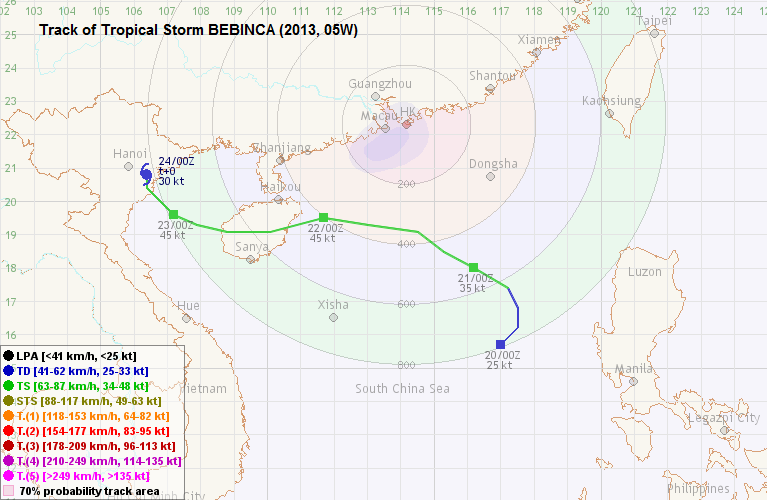
| Period of existence 生存時期 (JTWC) | 2013/06/20 20 HKT - 2013/06/23 14 HKT |
| Lifetime 壽命 (JTWC) | 2.75 days 日 |
| Maximum 1-minute wind (JTWC) JTWC 一分鐘平均最高中心風速 | 35 knots 節 (Tropical Storm 熱帶風暴) |
| Minimum pressure (JTWC) JTWC 最低氣壓 | 996 hPa 百帕 |
| Highest TC signal by HKO (if applicable) 香港天文台發出最高熱帶氣旋警告信號 |
3 (Strong Wind Signal 強風信號) |
| Closest point of approach by HKO (if applicable) 香港天文台所示之最接近距離 (如適用) |
SSW 340 km (real-time warning 實時報告 / TC report 熱帶氣旋報告) |
| Time of closest approach by HKO (if applicable) 香港天文台所示之最接近時間 (如適用) |
2013/06/22 00 HKT (real-time warning 實時報告 / TC report 熱帶氣旋報告) |
| Lowest pressure recorded at HKO (if applicable) 香港天文台錄得的最低氣壓 (如適用) |
1000.3 hPa 百帕 (2013/06/21 17:40 HKT) |
TC signals for Hong Kong & Track 香港曾經生效的熱帶氣旋警告和路徑圖:
Table 表:
| Signal 信號 |
Date and time 日期和時間 |
Distance from HK 與香港的距離 |
Predicted movement 預測移動方向和速度 |
Max. 10-min winds 中心最高十分鐘平均風速 |
 |
2013/06/21 (FRI) 07:40 HKT | SSE 530 km | NW at 18 km/h | 45 km/h (25 knots, TD) |
 |
2013/06/21 (FRI) 20:20 HKT | S 350 km | NW/WNW at 18 km/h | 75 km/h (40 knots, TS) |
|
2013/06/22 (SAT) 09:10 HKT | SW 410 km | W at 18 km/h | 85 km/h (45 knots, TS) |
 |
2013/06/22 (SAT) 11:15 HKT | SW 450 km | W at 22 km/h | 85 km/h (45 knots, TS) |
Figure 圖:
(Track courtesy of Lorenzo. Data from HKO. 鳴謝 Lorenzo 提供路徑圖,資料取自天文台)
Percentile rank among storms with #3 Signal (at compilation of this review)*: *This measures the relative wind strength in Hong Kong caused by this storm compared with others that share the same signal. 指標顯示此風暴相對於其他發出同樣信號的風暴為香港帶來之風力強度 For more information, please refer to Wind Speed Data for TCs that Have Affected Hong Kong. 更多資訊載於 影響香港氣旋之風速數據 頁 |
Overall: 總計: |
|
Moderately weak 中等偏弱 |
|||
| Component Ranks 分部等級 | ||||||
| Reference stations: 參考站: |
|
Weak 弱 |
||||
| Victoria Harbour: 維多利亞港: |
|
Moderate 中等 |
||||
| Urban: 市區: |
|
Moderately weak 中等偏弱 |
||||
| Offshore & high ground 離岸和高地: |
|
Moderately weak 中等偏弱 |
||||
Cyclones that attained similar rating (with signal #3): SOUDELOR (2009), WUKONG (2000), noname (2000/6) 相近級別之熱帶氣旋 (三號信號):蘇迪羅 (2009)、悟空 (2000)、無名 (2000/6) |
||||||
IR imagery animation 紅外線雲圖動畫:
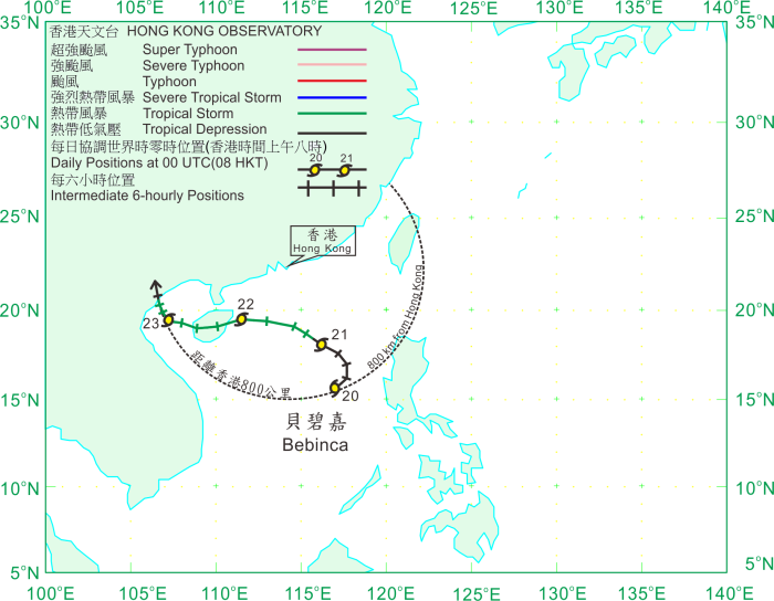
TC track from HKWW 本站的熱帶氣旋路徑圖:
TC track from HKO 天文台的熱帶氣旋路徑圖:
| Past HKWW Bulletins on BEBINCA 本站有關貝碧嘉的發佈 |
Please click here for bulletins on BEBINCA. 請按這裡。
| Storm Formation and Development 氣旋形成和發展 |
Unless otherwise stated, all times below are in Hong Kong Standard Time (UTC+8)
除非特別註明,下文時間均為香港標準時間 (協調世界時加 8 小時)
While tropical cyclone LEEPI was crossing the seas east of Taiwan, a tropical depression formed within the South China Sea on June 20. Due to the ample supply of moisture from the southwest monsoon, vigorous convective activity could be seen in the storm's southern semicircle. At that time, extension of the subtropical ridge was restricted by LEEPI. Influenced by the southwest monsoon, this depression initially moved northeast and edged closer to the western Luzon shore. The Observatory upgraded the system to a tropical depression at 9:30 am, while the JTWC performed the upgrade at 8 pm, assigning it the number 05W. Though moving northeast, such motion was not expected to persist for long as LEEPI was forecast to move out of the area quickly, which would allow the subtropical ridge to extend and push 05W westwards. Intensity projections were not optimistic as there were significant vertical wind shear in South China Sea at that time.
LEEPI moved into temperate regions quickly and the subtropical ridge started to extend westwards significantly at late June 20. As a result 05W turned north and avoided Luzon. It turned WNW on June 21 with signs of intensification, and the JMA upgraded 05W into a tropical storm that morning. The storm was named BEBINCA; the name was contributed by Macau and is the name of the Macanese milk pudding. It is of interest to note that the first usage of this name in 2000 resulted in a #1 Standby Signal as well. Due to the wind shear, BEBINCA's convections were concentrated at its western semicircle, and the low-level circulation centre was partially exposed.
於熱帶氣旋麗琵橫過台灣以東海域之時,另一熱帶低氣壓於 6 月 20 日在南海形成。由於西南季候風帶來充足水氣,該風暴南部的對流活動頗為猛烈。那時副熱帶高壓脊的西伸受麗琵阻擋,而受西南季候風的影響,該熱帶低氣壓初時向東北移動並靠近呂宋西部沿岸。香港天文台於當天上午 9 時 30 分將該系統升格為熱帶低氣壓,而 JTWC 則於當晚 8 時才升格,並給予風暴編號 05W。各模式一般預料麗琵即將移離,副高得以西伸並引領風暴西移, 05W 之東北路徑將不會持續。亦由於南海垂直風切變不低,強度預測並不樂觀。
麗琵很快便移至溫帶地區,副高於 6 月 20 日較後時間開始明顯西伸,令 05W 轉為北移,不再靠近呂宋。它於 21 日轉向西北偏西移動並增強,JMA 於當天早上將 05W 升格為熱帶風暴,並被命名為貝碧嘉。此名稱由澳門提供,為當地一種牛奶布丁的名稱。值得留意的是此名稱於 2000 年首次使用,該氣旋亦曾令天文台發出一號戒備信號。由於風切較高,貝碧嘉的對流集中在其西面,低層環流中心部分外露。

Figure 1 - Satellite image of BEBINCA at formation
圖 1 - 貝碧嘉形成時之衛星雲圖

Figure 2 - Initial forecast track from the Observatory
圖 2 - 天文台之初始預測路徑圖
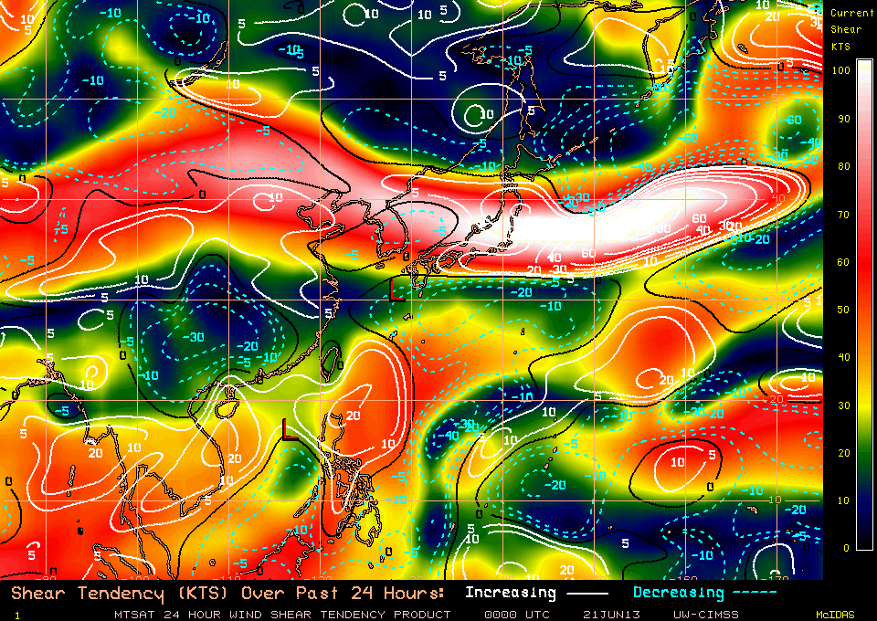
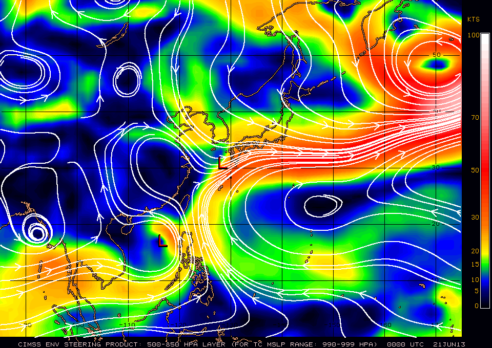
Figures 3a and 3b - Vertical wind shear and steering flow charts at 8 am, June 21
圖 3a 及 3b - 6 月 21 日上午 8 時之垂直風切變及駛流圖

Figure 4 - Forecast tracks by various official agencies on June 21
圖 4 - 官方氣象台 6 月 21 日之預測路徑
| Crossing South China Sea 橫過南海 |
As BEBINCA was expected to move closer to the territory, the Observatory issued the #1 Standby Signal at 7:40 am of June 21 when BEBINCA was around 530 km SSE of Hong Kong. At that time, most agencies were predicting that the WNW motion would persist and according to such forecast BEBINCA would pass at around 250 km SW of Hong Kong. The subtropical ridge turned out to be stronger than predicted and those forecasts never materialized.
Winds picked up gradually during the day as BEBINCA intensified and moved to the south of Hong Kong. At most stations, winds surged substantially at around 1-2 pm from the east. Although weak, BEBINCA's northern rainbands approached southern China coastal areas. Showers started to affect the territory after 3 pm. Winds at Waglan Island, Green Island, Cheung Chau Beach, Tate's Cairn and Ngong Ping reached strong force at around 3 pm, and continued to strengthen.
BEBINCA moved to within 400 km from Hong Kong and started to take a more westerly track that night. As winds were expected to strengthen further, the Observatory issued the #3 Strong Wind Signal at 8:20 pm. BEBINCA was situated at around 350 km south of the territory. The Observatory and the Chinese agencies raised BEBINCA's estimated strength to 45 knots (83 km/h) as BEBINCA's structure improved. Locally, more stations recorded strong force winds while some offshore and elevated stations like Ngong Ping were affected by gale force winds. Within Victoria Harbour, Kowloon Star Ferry station registered strong force easterly winds briefly before midnight. The Thunderstorm Warning was also issued as a blob of lightning was detected locally.
BEBINCA maintained considerable distance from Hong Kong overnight; it made its closest point of approach at around midnight June 22 at a distance of 340 km from the territory, still moving west steadily. Perhaps as a result of this, wind direction in Hong Kong did not change much during that night. Strong winds continued to affect the territory in the small hours of June 22. Cheung Chau was the only reference station that recorded gale force winds during the passage of BEBINCA; maximum 10-minute average sustained winds of 64 km/h were recorded shortly after 7 am.
隨著貝碧嘉靠近本港,天文台於 21 日上午 7 時 40 分發出一號戒備信號,當時貝碧嘉集結於本港東南偏南 530 公里處。當時大部分機構預計貝碧嘉將穩定向西北偏西移動,按照此預測貝碧嘉將於香港西南約 250 公里掠過。最終副高比預期強,這些預測均落空。
貝碧嘉逐步移至香港以南,本港風勢加強。大多數測風站於下午 1 至 2 時東風明顯增強,而貝碧嘉北面較弱的雨帶亦開始影響華南沿岸,本港於下午 3 時過後受驟雨影響。橫瀾島、青洲、長洲泳灘、大老山及昂坪風力於 3 時左右達強風程度,並有進一步增強之勢。
貝碧嘉其後進入本港 400 公里範圍,晚間採取偏西路徑移動。由於預計風力會增強,天文台於晚上 8 時 20 分發出三號強風信號,當時貝碧嘉處於本港以南約 350 公里。貝碧嘉的結構轉好,天文台及中國氣象台將其估計風速提高至 45 節 (每小時 83 公里)。本港方面,更多測風站錄得強風,而部分離岸及高地氣象站如昂坪則吹烈風。處於維多利亞港的九龍天星碼頭站於午夜前曾短暫吹強風。當晚本港亦探測到有閃電活動,雷暴警告因而生效。
貝碧嘉整晚與香港保持一段距離,它於 22 日午夜左右最接近本港,距離為 340 公里,並繼續穩定西移。或許貝碧嘉離香港較遠,本港風向於晚間並沒有太大改變,而強風於 22 日清晨繼續影響本港。長洲於上午 7 時後曾錄得每小時 64 公里的最高十分鐘平均風速,是唯一一個參考站受烈風侵襲。

Figure 5 - Rainbands associated with BEBINCA affecting Hong Kong. Lightning activity was detected.
圖 5 - 與貝碧嘉相關之雨區影響本港,並探測到閃電活動

Figure 6 - BEBINCA at closest point of approach to Hong Kong
圖 6 - 貝碧嘉最接近香港的時間


Figures 7a to 7c - Wind speed time series at Cheung Chau, Kowloon Star Ferry Pier and Waglan Island
圖 7a 至 7c - 長洲、九龍天星碼頭和橫瀾島的風速時間序列圖
| Landfalls and Weakening 登陸及減弱 |
The storm exited the 400-km circle at around 8 am that morning (June 22) and winds started to subside. The Observatory issued the #1 Standby Signal at 9:10 am, replacing the Strong Wind Signal. This signal did not last long as BEBINCA moved further away from Hong Kong, and was lifted at 11:15 am. According to Chinese authorities, BEBINCA made landfall at Tanmen, Hainan at around 11:10 am as a tropical storm. Torrential rain affected southern Hainan and gusts of force 8 to 10 were observed there.
As the storm crossed Hainan, it weakened slightly while still maintaining tropical storm strength. Showers continued to affect Hong Kong that day, but winds had fallen to below strong force level. BEBINCA entered the Gulf of Tonkin at around 9 pm. It took on an increasingly northerly track as the subtropical ridge extended at low latitudes and retreated at higher latitudes. It also regained some strength, albeit remaining as a tropical storm. It made its final landfall at northern Vietnam at nighttime of June 23, after spending one day in the Gulf. BEBINCA decelerated and weakened gradually on land. It weakened into a tropical depression and further a low pressure area in the morning of June 24.
貝碧嘉於 22 日早上 8 時左右離開香港 400 公里範圍,本港風力開始減弱,天文台於上午 9 時 10 分改發一號戒備信號以取代三號強風信號。而因貝碧嘉進一步離開,戒備信號發出後不久便於上午 11 時 15 分解除。根據中國當局,貝碧嘉於上午 11 時 10 分以熱帶風暴強度在海南潭門登陸。海南南部下起傾盆大雨,陣風風力達 8 至 10 級。
貝碧嘉在橫過海南時稍為減弱,但仍保持熱帶風暴強度。香港於當天仍受驟雨影響,但風力已減弱至強風程度以下。貝碧嘉於當晚約 9 時進入北部灣。副熱帶高壓脊於低緯度西伸並於高緯度東退,使貝碧嘉移向逐漸偏北。貝碧嘉亦再度增強,但仍只為一熱帶風暴。於北部灣前進一日後,它於 23 日晚間登陸越南北部,於陸上減弱並減速。貝碧嘉於 24 日早上減弱為熱帶低氣壓,繼而減弱為低壓區。

Figure 8 - Steering flow chart at 8 am, June 23
圖 8 - 6 月 23 日上午 8 時之駛流圖

Figure 9 - Forecast tracks by various official agencies on June 23
圖 9 - 官方氣象台 6 月 23 日之預測路徑
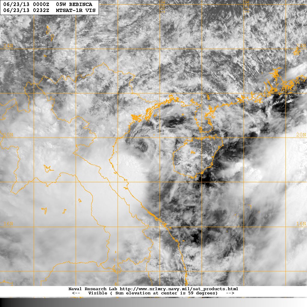
Figure 10 - BEBINCA crossing the Gulf of Tonkin
圖 10 - 貝碧嘉正橫過北部灣
| Winds Recorded at Reference Stations 參考站所錄得的風速 |
| Station 風速站 |
Max. 10-min avg. wind speed 最高十分鐘平均風速 |
Beaufort classification 蒲福氏風級分類 |
| Chek Lap Kok 赤鱲角 | 44 km/h | STRONG 強風 |
| Cheung Chau 長洲 | 64 km/h | GALE 烈風 |
| Kai Tak 啟德 | 38 km/h | Fresh 清勁 |
| Lau Fau Shan 流浮山 | 36 km/h | Fresh 清勁 |
| Sai Kung 西貢 | 43 km/h | STRONG 強風 |
| Sha Tin 沙田 | 24 km/h | Moderate 和緩 |
| Ta Kwu Ling 打鼓嶺 | 20 km/h | Moderate 和緩 |
| Tsing Yi (SHL) 青衣蜆殼油庫 | 25 km/h | Moderate 和緩 |
| Number of stations recording at least STRONG force (force 6 - 7) winds: | 3 |
| Number of stations recording at least GALE force (force 8 - 9) winds: | 1 |
| Number of stations recording at least STORM force (force 10 - 11) winds: | 0 |
| Number of stations recording HURRICANE force (force 12) winds: | 0 |
| 錄得 強風 (6 - 7 級) 或更高風速的站數: | 3 |
| 錄得 烈風 (8 - 9 級) 或更高風速的站數: | 1 |
| 錄得 暴風 (10 - 11 級) 或更高風速的站數: | 0 |
| 錄得 颶風 (12 級) 風速的站數: | 0 |
| Charts and Figures 各項數據 |
Table 1: Track data from HKWW:
表一 : 香港天氣觀測站之路徑資料
YYMMDDZZ Lat Long Wind |
Table 2: Maximum gust and hourly average wind speed recorded in Hong Kong from HKO:
表二 : 香港天文台公佈的各站最高每小時平均風力和陣風數據
| Station | Maximum Gust | Maximum Hourly Mean Wind | ||||||
| Direction | Speed (km/h) | Date/Month | Time | Direction | Speed (km/h) | Date/Month | Time | |
| Bluff Head (Stanley) | ENE | 63 | 21/6 | 18:58 | E | 34 | 21/6 | 23:00 |
| ENE | 63 | 21/6 | 19:16 | |||||
| Central Pier | ENE | 58 | 21/6 | 22:08 | E | 38 | 21/6 | 21:00 |
| Cheung Chau | ESE | 77 | 22/6 | 00:32 | SE | 47 | 22/6 | 08:00 |
| Cheung Chau Beach | ESE | 72 | 22/6 | 04:53 | E | 47 | 21/6 | 19:00 |
| Green Island | NE | 75 | 21/6 | 19:42 | NE | 54 | 21/6 | 18:00 |
| Hong Kong International Airport | SE | 59 | 22/6 | 07:29 | ESE | 34 | 21/6 | 16:00 |
| Kai Tak | E | 59 | 21/6 | 19:16 | E | 30 | 22/6 | 00:00 |
| King's Park | SE | 54 | 22/6 | 01:31 | ESE | 23 | 22/6 | 02:00 |
| Lau Fau Shan | ENE | 67 | 21/6 | 20:32 | E | 31 | 21/6 | 21:00 |
| Ngong Ping | E | 99 | 22/6 | 03:57 | E | 72 | 22/6 | 04:00 |
| North Point | E | 67 | 21/6 | 17:48 | E | 31 | 21/6 | 21:00 |
| E | 31 | 21/6 | 23:00 | |||||
| Peng Chau | E | 59 | 21/6 | 20:17 | E | 40 | 21/6 | 20:00 |
| Ping Chau | E | 40 | 21/6 | 17:42 | E | 12 | 21/6 | 18:00 |
| Sai Kung | SSE | 70 | 22/6 | 05:25 | ENE | 38 | 21/6 | 19:00 |
| Sha Chau | SSE | 63 | 22/6 | 05:17 | SE | 36 | 22/6 | 06:00 |
| Sha Lo Wan | E | 63 | 21/6 | 22:18 | E | 31 | 21/6 | 21:00 |
| Sha Tin | ENE | 58 | 22/6 | 05:34 | NNE | 19 | 21/6 | 21:00 |
| Shek Kong | ENE | 51 | 21/6 | 23:28 | E | 23 | 22/6 | 00:00 |
| Star Ferry (Kowloon) | E | 59 | 21/6 | 20:33 | E | 40 | 22/6 | 00:00 |
| Ta Kwu Ling | ENE | 47 | 21/6 | 18:48 | ENE | 16 | 21/6 | 19:00 |
| ENE | 16 | 21/6 | 21:00 | |||||
| Tai Mei Tuk | E | 68 | 22/6 | 05:30 | E | 45 | 21/6 | 23:00 |
| Tai Mo Shan | E | 94 | 21/6 | 22:37 | E | 67 | 22/6 | 00:00 |
| E | 94 | 21/6 | 23:29 | |||||
| Tai Po Kau | SE | 65 | 22/6 | 05:39 | ESE | 36 | 21/6 | 23:00 |
| Tap Mun | E | 49 | 21/6 | 18:20 | ESE | 23 | 22/6 | 06:00 |
| Tate's Cairn | ESE | 87 | 21/6 | 18:04 | SE | 56 | 22/6 | 00:00 |
| Tseung Kwan O | ESE | 47 | 21/6 | 20:20 | E | 14 | 21/6 | 21:00 |
| Tsing Yi Shell Oil Depot | E | 54 | 22/6 | 00:18 | E | 20 | 22/6 | 03:00 |
| Tuen Mun Government Offices | SSE | 52 | 22/6 | 05:24 | SE | 14 | 22/6 | 07:00 |
| Waglan Island | E | 65 | 21/6 | 18:06 | E | 52 | 21/6 | 19:00 |
| E | 52 | 21/6 | 20:00 | |||||
| Wetland Park | ESE | 40 | 21/6 | 15:48 | E | 19 | 21/6 | 18:00 |
| Wong Chuk Hang | SE | 67 | 22/6 | 02:08 | E | 30 | 21/6 | 21:00 |
Table 3: Rainfall (in millimetres) contributed by BEBINCA from HKO (figures in brackets are based on incomplete hourly data):
表三 : 香港天文台公佈的各站雨量資料 (方括號內之數據由不完整之每小時資料擷取)
| Station | 21-Jun |
22-Jun |
Total(mm) |
|
| Hong Kong Observatory | 0.8 |
15.2 |
16.0 |
|
| Hong Kong International Airport (HKA) | 1.4 |
25.9 |
27.3 |
|
| Cheung Chau (CCH) | 0.0 |
27.0 |
27.0 |
|
| N05 | Fanling | 0.0 |
44.5 |
44.5 |
| N13 | High Island | 0.5 |
44.0 |
44.5 |
| K04 | Jordan Valley | 2.5 |
24.0 |
26.5 |
| N06 | Kwai Chung | [0.5] |
[14.0] |
[14.5] |
| H12 | Mid Levels | 2.5 |
21.0 |
23.5 |
| N09 | Sha Tin | 1.0 |
52.0 |
53.0 |
| H19 | Shau Kei Wan | 3.5 |
15.0 |
18.5 |
| SEK | Shek Kong | 2.5 |
23.5 |
26.0 |
| K06 | So Uk Estate | 1.5 |
15.0 |
16.5 |
| R31 | Tai Mei Tuk | 0.0 |
35.5 |
35.5 |
| R21 | Tap Shek Kok | 8.0 |
20.0 |
28.0 |
| N17 | Tung Chung | 1.0 |
38.5 |
39.5 |
| R27 | Yuen Long | 0.0 |
16.5 |
16.5 |
Last Accessed 最近訪問日期: Sat Apr 20 2024 01:14:25 HKT
Last Modified 最近修訂日期: Mon Jul 24 2023
