
TC Watch / 熱帶氣旋 > Selected TC Review / 重要熱帶氣旋回顧 > 201311W (UTOR 尤特) [Refresh 更新]
 201311W (UTOR 尤特) - Profile 檔案 201311W (UTOR 尤特) - Profile 檔案 |
(First draft issued on September 10, 2013; final version issued on October 28, 2013)
(初稿於 2013 年 9 月 10 日發出,最後版本於 2013 年 10 月 28 日上載)
Brief profile of UTOR 尤特小檔案:
| JTWC number 聯合颱風警報中心 (JTWC) 號碼 | 11W |
| International number 國際編號 | 1311 |
| Period of existence 生存時期 (JTWC) | 2013/08/09 02 HKT - 2013/08/17 20 HKT |
| Lifetime 壽命 (JTWC) | 8.75 days 日 |
| Maximum 1-minute wind (JTWC) JTWC 一分鐘平均最高中心風速 | 130 knots 節 (Category 4 Super Typhoon 四級超級颱風) |
| Minimum pressure (JTWC) JTWC 最低氣壓 | 926 hPa 百帕 |
| Highest TC signal by HKO (if applicable) 香港天文台發出最高熱帶氣旋警告信號 |
8 (SE) (Gale or Storm Signal 烈風或暴風信號) |
| Closest point of approach by HKO (if applicable) 香港天文台所示之最接近距離 (如適用) |
WSW 240 km (real-time warning 實時報告 / TC report 熱帶氣旋報告) |
| Time of closest approach by HKO (if applicable) 香港天文台所示之最接近時間 (如適用) |
2013/08/14 15 HKT (real-time warning 實時報告) / 13 HKT (TC report 熱帶氣旋報告) |
| Lowest pressure recorded at HKO (if applicable) 香港天文台錄得的最低氣壓 (如適用) |
996.8 hPa 百帕 (2013/08/14 03:37 HKT) |
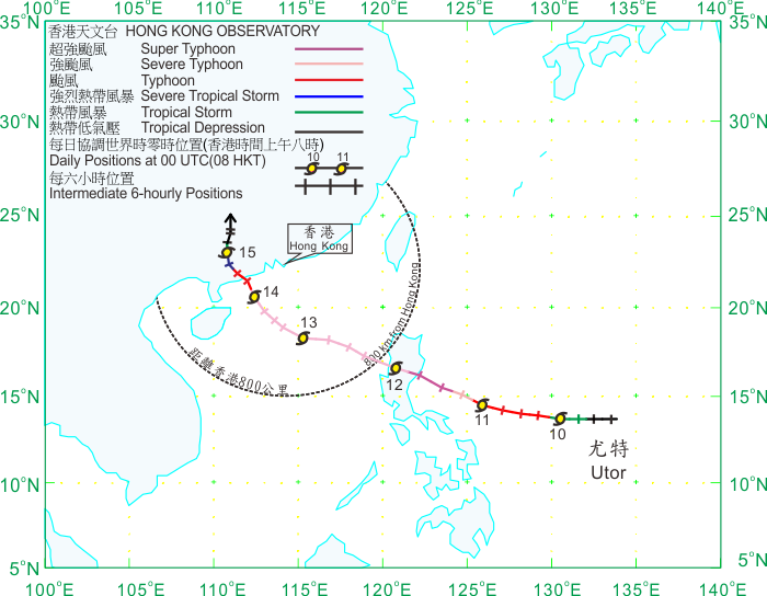
TC signals for Hong Kong & Track 香港曾經生效的熱帶氣旋警告和路徑圖:
Table 表:
| Signal 信號 |
Date and time 日期和時間 |
Distance from HK 與香港的距離 |
Predicted movement 預測移動方向和速度 |
Max. 10-min winds 中心最高十分鐘平均風速 |
 |
2013/08/12 (MON) 16:05 HKT | SE 710 km | WNW at 22 km/h | 155 km/h (85 knots, CAT. 2 / ST) |
 |
2013/08/13 (TUE) 04:40 HKT | SSE 490 km | WNW at 18 km/h | 155 km/h (85 knots, CAT. 2 / ST) |
 |
2013/08/14 (WED) 01:40 HKT | SSE 310 km | NW at 16 km/h | 175 km/h (95 knots, CAT. 2 / ST) |
|
2013/08/14 (WED) 13:40 HKT | WSW 240 km | NW/NNW at 16 km/h | 155 km/h (85 knots, CAT. 2 / ST) |
|
2013/08/15 (THU) 01:40 HKT | W 350 km | NW at 14 km/h | 110 km/h (60 knots, STS) |
 |
2013/08/15 (THU) 16:40 HKT | WNW 370 km | Slow movement | 55 km/h (30 knots, TD) |
Figure 圖:
(Track courtesy of Lorenzo. Data from HKO. 鳴謝 Lorenzo 提供路徑圖,資料取自天文台)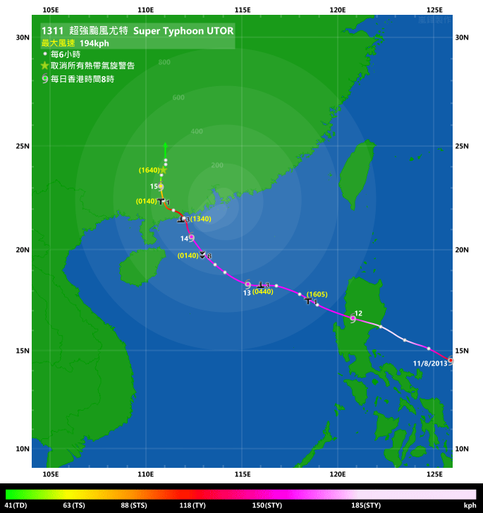
Percentile rank among storms with #8 Signal (at compilation of this review)*: *This measures the relative wind strength in Hong Kong caused by this storm compared with others that share the same signal. 指標顯示此風暴相對於其他發出同樣信號的風暴為香港帶來之風力強度 For more information, please refer to Wind Speed Data for TCs that Have Affected Hong Kong. 更多資訊載於 影響香港氣旋之風速數據 頁 |
Overall: 總計: |
|
Moderately weak 中等偏弱 |
|||
| Component Ranks 分部等級 | ||||||
| Reference stations: 參考站: |
|
Moderately weak 中等偏弱 |
||||
| Victoria Harbour: 維多利亞港: |
|
Moderately weak 中等偏弱 |
||||
| Urban: 市區: |
|
Moderately weak 中等偏弱 |
||||
| Offshore & high ground 離岸和高地: |
|
Weak 弱 |
||||
Cyclones that attained similar rating (with signal #8): KAI-TAK (2012), KOMPASU (2004), KENT (1995) 相近級別之熱帶氣旋 (八號信號):啟德 (2012), 圓規 (2004), 肯特 (1995) |
||||||
IR imagery animation 紅外線雲圖動畫:
TC track from HKWW 本站的熱帶氣旋路徑圖:

TC track from HKO 天文台的熱帶氣旋路徑圖:
| Past HKWW Bulletins on UTOR 本站有關尤特的發佈 |
Please click here for bulletins on UTOR. 請按這裡。
| Storm Formation and Development 氣旋形成和發展 |
Unless otherwise stated, all times below are in Hong Kong Standard Time (UTC+8)
除非特別註明,下文時間均為香港標準時間 (協調世界時加 8 小時)
A disturbance developed quickly in the tropical Pacific on August 8. A tropical cyclone formation alert was issued by the JTWC at 8 pm that night, and the system was upgraded into tropical depression 11W at 2 am the next day. 11W formed as a small system, and was projected to have great potential as it was expected to travel on sea for a few days with high surface temperatures and in a low shear environment. Initial model outputs favoured a persistent WNW track followed by a more poleward turn as the system entered the South China Sea, and this synopsis was echoed by the JTWC.
11W moved WNW along the southern periphery of the subtropical ridge during the day. The JMA issued a gale warning for the system at 2 am August 9 while the HKO upgraded the system into a tropical depression at around 4 pm the same day. 11W was finally upgraded into tropical storm status by the JMA at 2 am August 10 when it was around 1200 km east of Manila. The storm was named UTOR which comes from the USA. It is a Marshallese word, meaning squall line. The tropical cyclone associated with this name necessitated the #8 Gale or Storm Signal back in 2001. Initial track forecasts from various agencies were quite divergent, with landfall at Luzon predicted by the JTWC to crossing the Luzon Strait by the JMA.
UTOR expanded in size and started to intensify at a quicker rate on August 10. The HKO upgraded UTOR into a tropical storm, severe tropical storm and typhoon at 4 am, noon and 4 pm respectively. In an almost shearless environment UTOR developed a central dense overcast rapidly and an eye became visible on satellite images near noon that day. UTOR turned equatorward on that day and agencies revised their forecast tracks westwards, and landfall at Luzon became increasingly likely.
Due to UTOR's potential intensity and threat to Hong Kong as shown in HKO's forecast track, certain media agencies inappropriately reported a direct hit prediction. In a rare move, the HKO dismissed such false information by issuing a press release. It was emphasized that the forecast track error increases with time and that another tropical disturbance in the South China Sea at that time might induce further uncertainty.
UTOR continued to intensify overnight and started to track WNW again, but convections in its northeastern quadrant diminished somewhat. The JTWC estimated UTOR's strength at 100 knots (185 km/h) at 8 am August 11. This was revised upwards to 115 knots (213 km/h) at 2 pm and 130 knots (241 km/h) at 8 pm as a well-defined eye appeared on infrared satellite imagery in the afternoon and that the eye cleared up gradually. The HKO also upgraded UTOR into a severe typhoon at noon and further into a super typhoon at 10 pm. UTOR reached peak intensity that night as the eye clogged up again near midnight, just before impacting the Philippines.
一個擾動於 8 月 8 日在熱帶太平洋上快速發展。JTWC 於當晚 8 時為該擾動發出熱帶氣旋形成警報,並於 9 日上午 2 時將其升格為熱帶低氣壓 11W。11W 形成初期較為細小,由於預料會於未來數天橫過高溫的海面及低垂直風切變的地區,11W 有成為強烈系統的潛質。初始模式預報顯示 11W 將持續向西北偏西移動,並於進入南海後採取較為偏北的方向移動,JTWC 於其首報中採取此預測情境。
11W 於 9 日在副熱帶高壓脊南部向西北偏西移動。JMA 於上午 2 時發出烈風警告,而天文台則於約上午 4 時升格該系統為熱帶低氣壓。11W 於 10 日上午 2 時被 JMA 升格為熱帶風暴,當時 11W 於馬尼拉以東約 1200 公里。11W 被命名為尤特,此名稱由美國提供,在馬紹爾語中解作颮線。2001 年名為尤特的熱帶氣旋曾令天文台發出八號烈風或暴風信號。各氣象台的初始預報分歧較大,JTWC 預計尤特會登陸呂宋,而 JMA 則預料尤特會橫過呂宋海峽。
尤特的尺度於 10 日變大,並以較快速度增強。天文台分別於當天上午 4 時、正午及下午 4 時將尤特逐步升格至熱帶風暴、強烈熱帶風暴及颱風。在幾乎沒有風切的環境下,尤特很快發展出中心密集雲區,中午時份雲圖上出現一風眼。尤特於當天移向較為偏西,各台紛紛將預測路徑西調,系統於呂宋登陸的機會增加。
由於尤特預測強度較高,且天文台的路徑圖上顯示尤特對香港構成一定威脅,部分傳媒錯誤使用「吹正本港」的描述。天文台罕有地發出新聞稿以作澄清,強調預測誤差隨時間增加,且當時於南海的另一擾動或會增加尤特路徑之不確定性。
尤特當晚繼續增強,並開始回復西北偏西之路徑,但其東北象限對流有所減少。JTWC 於 11 日上午 8 時估計尤特中心附近最高風速達 100 節 (每小時 185 公里)。由於尤特的風眼於下午時份在紅外線衛星雲圖上變得更為清晰,該強度估算於下午 2 時及 8 時分別上調至 115 及 130 節 (每小時 213 及 241 公里)。至於天文台則於中午將尤特升格為強颱風,並於晚上 10 時升格為超強颱風。尤特於當晚到達巔峰強度,午夜過後風眼開始被雲層填塞,當時尤特即將登陸菲律賓。

Figure 1 - Steering flow chart at 8 am, August 10
圖 1 - 8 月 10 日上午 8 時之駛流場圖

Figure 2 - Track forecasts from various agencies on August 10
圖 2 - 各氣象台於 8 月 10 日之路徑預測

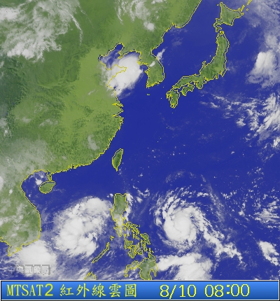
Figures 3a to 3c - Satellite images of UTOR on August 8, 9 and 10
圖 3a 至 3c - 尤特於 8 月 8、9 及 10 日之衛星圖

Figure 4 - Wind vectors near UTOR's centre in the night of August 11
圖 4 - 8 月 11 日晚尤特近中心之風向量圖

Figure 5 - UTOR at peak intensity just before hitting the Philippines
圖 5 - 尤特於即將吹襲菲律賓時達到巔峰強度
| Crossing Luzon and Entering South China Sea 橫過呂宋並進入南海 |
UTOR made landfall at Aurora Province at around 2 am August 12. Although it had weakened by that time, it still packed winds of around 100-110 knots (185-204 km/h) capable of producing severe damage to Luzon. Flooding occurred around the Province and power was cut due to the intense wind and rain. The storm continued its WNW track, but weakened heavily as it crossed the most mountainous regions of the country. It entered the South China Sea in late morning as a category 2 typhoon, after spending just about 8 hours in Luzon, while the HKO downgraded the storm into a severe typhoon. Deterioration of UTOR's structure became apparent a few hours later; the central dense overcast had collapsed but convections were still wrapping tightly around the centre.
By that time most agencies predicted a WNW movement followed by a turn to the NW at reduced speeds as the subtropical ridge in the East China Sea was expected to be eroded by a passing trough. UTOR entered Hong Kong's 800-km region in the early afternoon. The Observatory issued the #1 Standby Signal at 4:05 pm when UTOR was 710 km SE of Hong Kong. Soon after signal issuance, rumours regarding times of issuance for higher signals surfaced on the internet. The HKO again reacted quickly and clarified in the form of a special weather tip and the clarification message was also displayed in the hourly weather readings.
UTOR's subsidence resulted in very hot weather locally. Temperatures in various regions surpassed the 35-degree mark; the maximum temperature at the Observatory was 34.9 degrees, the highest so far this year. The mercury at Sheung Shui and Lau Fau Shan reached 37.5 and 36.0 degrees respectively.
A ragged eye was visible later that evening but was short-lived. Due to its relatively high speed UTOR entered the 600-km radius by midnight August 13. As winds were expected to strengthen when UTOR moved to Hong Kong's southwestern quadrant, the Observatory issued the #3 Strong Wind Signal at 4:40 am. The issuance was in part a precautionary measure as winds were mostly moderate at that time except at some offshore and high ground stations, and in part due to the wide wind radii associated with UTOR --- in HKO's Tropical Cyclone Warning for Shipping the 2-metre wave and gale radii were estimated at 270 NM (500 km) and 180 NM (333 km) respectively.
尤特於 8 月 12 日上午 2 時左右於奧羅拉省登陸。雖然登陸前稍為減弱,但當時尤特風速仍達 100 至 110 節 (每小時 185 至 204 公里),足夠為呂宋帶來嚴重破壞。該省多處出現水災,狂風大雨令供電受影響。風暴繼續向西北偏西移動,而由於它橫過菲律賓的最高山脈,它的強度大幅減弱。尤特登陸 8 小時後便於早上末段以二級颱風強度進入南海,而天文台亦將風暴降格為強颱風。尤特的結構於之後的數小時明顯轉差,其中心密集雲區瓦解,但對流仍緊緊圍繞中心轉動。
出海後,大部分機構的預測均指尤特將向西北偏西移動,其後於東海的副高將被西風槽削弱,尤特將減速並轉向西北移動。風暴於當天下午早段時間進入本港 800 公里範圍,而天文台則於下午 4 時 05 分發出一號戒備信號,當時尤特位於本港東南約 710 公里。信號發出後不久,網上流傳改發更高信號的時間表,天文台迅速以特別天氣提示的形式澄清,該信息更於每小時溫度濕度報告中提及。
尤特的下沉氣流令本港天氣酷熱。香港部分地區溫度升逾 35 度;天文台於下午錄得當時全年最高溫 34.9 度,至於上水及流浮山更分別錄得 37.5 及 36.0 度的高溫。
一個不規則的風眼於當晚短暫出現。由於尤特移速較高,它於 13 日午夜時份已進入本港 600 公里範圍。由於預料風勢將於尤特到達本港西南象限時增強,天文台於上午 4 時 40 分發出三號強風信號。由於信號發出時本港大多地方風力只達和緩程度,此信號預警味道較濃。尤特風圈頗為廣闊,天文台於為船舶提供的熱帶氣旋警告中估計 2 米浪高圈及烈風圈半徑分別為 270 及 180 海里 (500 及 333 公里),這亦可能是信號較早發出的原因。

Figure 6 - Track forecasts from various agencies on August 12
圖 6 - 各氣象台於 8 月 12 日之路徑預測
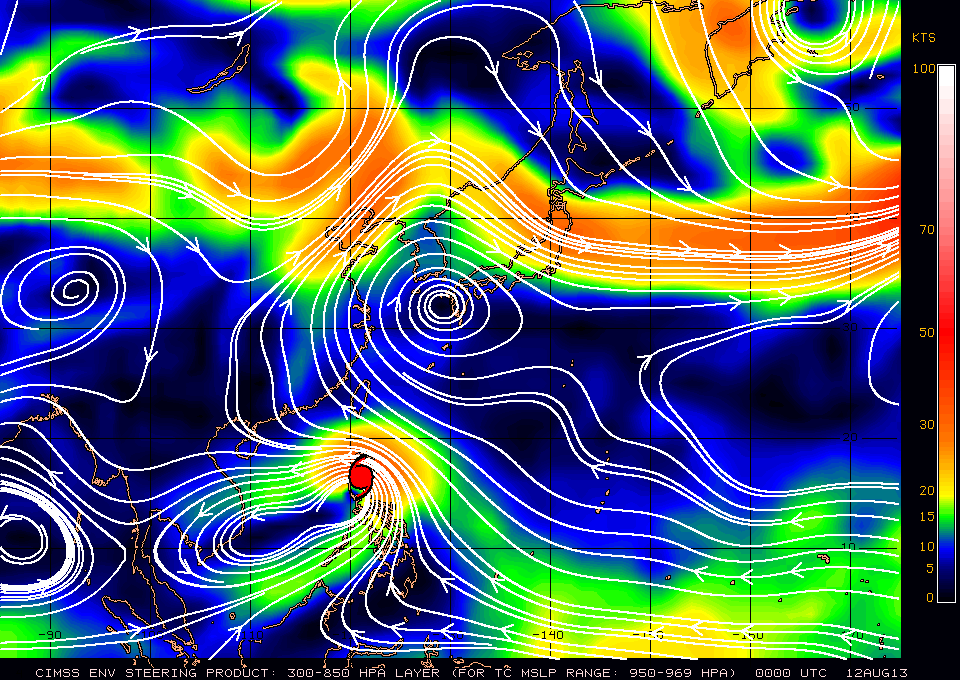
Figure 7 - Steering flow chart at 8 am, August 12
圖 7 - 8 月 12 日上午 8 時之駛流場圖

Figure 8 - Extreme air temperatures due to UTOR's subsidence
圖 8 - 尤特的下沉氣流為本港帶來極端氣溫

Figure 9 - HKO's forecast track. Notice UTOR's wide wind radii
圖 9 - 天文台之預測路徑,留意尤特風圈頗大
| Approaching South China Coastal Areas 靠近華南沿岸 |
The first rainband arrived at around 9 am and rain intensified gradually in the morning. An announcement came at noon that handling of laden cargoes would stop at 4 pm, hinting at increasing wind speeds. UTOR's structure was seen improving during the day and its size expanded further; the Observatory raised its intensity estimate from 155 km/h to 175 km/h. Just as agencies predicted, UTOR slowed down considerably in the afternoon and was almost stationary at around 380 km south of Hong Kong, which was apparently a sign of a change in direction. The Observatory noted this in their tropical cyclone warning bulletin and mentioned that higher signals may be considered that night.
After halting for an hour or two, UTOR started to move northwest slowly. Its trajectory was somewhat ragged but was stable towards the northwest on the average. Winds started to pick up locally near sunset; sustained strong winds were recorded at Cheung Chau, Green Island, Peng Chau and Tai Mei Tuk, while Ngong Ping, Tate's Cairn, Waglan Island recorded gale force winds. There were some reports of falling trees and numerous flights were delayed or cancelled.
The Observatory issued the Pre-No. 8 Special Announcement at 11:40 pm giving a two-hour warning to the public before the issuance of the #8 Signal. At that time only one out of the eight reference stations (Cheung Chau) had recorded gale force winds, and that duration was brief. Suspensions to local ferry services and jetfoil services between Hong Kong and Macau after 1:30 or 2 am August 14 were announced shortly afterwards. Overnight bus services were also suspended, while regular routes were not affected since it was already close to the normal time of the last despatch, although they would not operate in the morning should the #8 Signal be still in force.
Exactly two hours after the Pre-No. 8 Announcement, the #8 Southeast Gale or Storm Signal was issued at 1:40 am August 14 when UTOR was 310 km SSW of Hong Kong. This marked the first issuance of the #8 Signal this year. As UTOR was expected to be closest to Hong Kong after daybreak, the Observatory said that the Signal would remain in force for most of the morning. Rain became occasional as the most intense rainbands had passed. Winds did become stronger during the rest of the night but only minimally; Cheung Chau was again the only reference station that managed to record persistent gale force winds, while winds at Chek Lap Kok touched the gale force threshold (63 km/h) just once at 6 am. Several other stations also recorded elevated wind speeds between 5:30 and 6 am due to another passing rainband. The Observatory lowered UTOR's strength to 165 km/h at 4 am and confirmed that the #8 Signal would remain in force for the whole morning an hour later. Meanwhile, Macau hoisted the #8 NE Gale or Storm Signal at 5 am but winds were already turning to the ESE by that time; hence the signal was changed to #8 SE at 8 am.
More suspension of service announcements emerged as daytime arrived, including tram, peak tram, Star Ferry, schools, public exam, financial market, among others, while MTR retained limited service. As wind direction started to turn to the southeast in the morning, crosswinds affected Chek Lap Kok and even more flights were delayed. Wind strength remained more or less constant in the morning, despite the fact that UTOR was still moving closer to the territory. As persistent gales became unlikely and UTOR showed signs of weakening, the Observatory indicated the possibility of considering a lower signal in the afternoon in its 10 am bulletin. The time was made clear to be 2 pm in the following bulletin. Bus services resumed after 1 pm but ferry services were scheduled to resume later as seas were still very rough. The Observatory replaced the #8 Signal by the #3 Strong Wind Signal at 1:40 pm, exactly 12 hours after the issuance of the #8 Signal. However, winds were picking up at that time, most notably at Cheung Chau which reached its peak wind speed during UTOR's visit at 77 km/h. This sparked some controversy over the timing of the signal change due to inconsistencies, but in general local winds were calm enough to justify the Strong Wind Signal.
It was also an awkward moment for commuters as some had to return to office in 2 hours after the lowering of the Signal #8. Fortunately the Observatory had been announcing a signal change for a few hours which allowed citizens to prepare. Soon after bus services resumed the streets are packed with people who must report for work. Meanwhile, at Macau the #8 Signal was lowered to the #3 Signal at 3:30 pm.
尤特的首道外圍雨帶於上午 9 時左右到達本港,雨勢於早上增強。中午時份貨櫃公司宣佈將於下午 4 時暫停重櫃交收,暗示風勢將會增強。尤特當天結構轉好,其尺度進一步擴大,天文台的風速估算由每小時 155 公里上調至每小時 175 公里。跟氣象台預測一樣,尤特於下午大幅減慢,更一度於本港以南約 380 公里處於停滯狀態,這為轉向的明顯徵兆。天文台於熱帶氣旋警報中包括此項變化,並表示當晚或會考慮改發更高信號。
停滯一兩小時後,尤特開始向西北緩慢移動。雖然它的移向較不規則,但總體來說它大致向西北移。風速於日落前後上升,長洲、青洲、坪洲及大美督持續吹強風,而昂坪、大老山及橫瀾島吹烈風。政府開始接獲塌樹報告,不少航班因颱風影響延遲或取消。
天文台於晚上 11 時 40 分發出預警八號熱帶氣旋警告信號之特別報告,預告將於兩小時內改發八號信號。於此預警發出時,八個參考測風站中只有長洲一站錄得烈風,且為時短暫。此後不久船公司宣布本地及港澳渡輪會於 14 日凌晨 1 時 30 分至 2 時開始停航。通宵巴士服務亦會暫停,而日間巴士則因當時已接近收車時間而不受影響,但如果早上八號信號仍然生效將會繼續暫停服務。
預警發出後兩小時,即 14 日凌晨 1 時 40 分,天文台改發八號東南烈風或暴風信號,尤特當時處於本港西南偏南約 310 公里,而此亦為本年度首個八號風球。由於預計尤特會於日出後最接近香港,天文台宣佈八號信號會在早上大部分時間維持。這時,尤特最強烈的雨帶已過,香港雨勢變為間歇性;至於風勢則有所增強,但幅度不大,長洲是唯一能持續吹烈風的參考站,至於赤鱲角則只於上午 6 時錄得一次剛好達烈風下限 (每小時 63 公里) 的風速。由於受另一道雨帶影響,部分氣象站於早上 5 時 30 分至 6 時間錄得較強風速。天文台於上午 4 時下調尤特的中心風力至每小時 165 公里,並於一小時後確認八號信號會於整個早上維持。另一方面,澳門於上午 5 時改掛八號東北風球,但由於當時風向已開始轉為東南偏東,該信號於上午 8 時被八號東南風球取代。
日出過後傳來更多服務暫停的消息,包括但不限於電車、山頂纜車、天星小輪、學校、公開考試及金融市場,而港鐵則維持有限度服務。隨著風向於早上轉為東南,機場受側風影響,更多航班被延誤。雖然尤特繼續靠近本港,但本地風勢於早上變化不大。種種跡象顯示本港受持續烈風影響的機會不高,而且尤特正開始其減弱趨勢,這令天文台於上午 10 時表示或會於下午考慮改發較低信號,於一小時後更確定為下午 2 時前後。巴士服務於下午 1 時恢復,但渡輪服務則由於海面情況仍然較差而延遲恢復。天文台於八號信號生效 12 小時後,即下午 1 時 40 分改發三號強風信號,但風勢正於此時增強,長洲更錄得尤特自影響本港以來該站的最高風速每小時 77 公里。這對天文台改發較低信號的時間引發一些爭議,但整體來說本地風勢不太強,三號信號算是恰當。
對於部分需要於八號信號取消後兩小時內回到工作崗位的打工仔來說,此「落波」時間頗為尷尬,但由於天文台已於數小時前預估改發較低信號時間,市民能以作充分準備。八號信號取消後不久,街上滿佈趕著上班的人群。澳門方面,八號風球於下午 3 時 30 分被三號風球取代。


Figures 10a to 10f - Radar images at 3-hour intervals from midnight to 3 pm, August 14
圖 10a 至 10f - 8 月 14 日午夜至下午 3 時每三小時的雷達圖


Figures 11a to 11f - Local wind distribution maps at 4-hour intervals from 10 pm August 13 to 6 pm August 14
圖 11a 至 11f - 8 月 13 日下午 10 時至 14 日下午 6 時每四小時的本港風勢分布圖


Figures 12a to 12d - Wind speed time series at Chek Lap Kok, Cheung Chau, Kai Tak and Waglan Island
圖 12a 至 12d - 赤鱲角、長洲、啟德及橫瀾島的風速時間序列圖

Figure 13 - Estimated wind field at 2 pm August 14 showing wide gale radius east of the storm centre
圖 13 - 8 月 14 日下午 2 時之風場估算顯示風暴東面烈風圈頗為廣闊
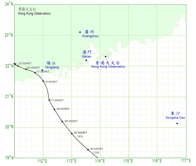
| Making Landfall at Western Guangdong and Gradual Weakening 登陸廣東西部並逐漸減弱 |
Going back to UTOR, the storm travelled increasingly poleward in the first half of August 14. This delayed the time of its closest approach to Hong Kong to around 3 pm when UTOR was 240 km WSW of Hong Kong, still as a severe typhoon. It soon made landfall near Yangjiang, Guangdong at around 4 pm and weakened into a typhoon. Weather stations there recorded wind speeds at the level of a severe typhoon, justifying the HKO's previous intensity estimate. It turned WNW sharply after rainfall, possibly as a result of land interaction. Due to the intensification of an equatorial ridge, southwesterly winds were blowing in the northwestern part of the South China Sea. This continued to bring in moisture to UTOR which led to its slow degeneration.
Locally, winds were slowly weakening towards late evening especially at Cheung Chau, but some stations like Sha Chau, Green Island and Stanley were still affected by strong winds. This was partly because UTOR's distance to Hong Kong did not increase significantly after landfall, and partly because wind direction changed to the south and rendered many stations exposed to the wind.
UTOR weakened into a severe tropical storm near 1 am August 15 but resumed its northerly motion. The Observatory replaced the #3 Signal by the #1 Standby Signal at 1:40 am as strong winds were confined to offshore locations and high ground. However, winds seemed to pick up a bit after the signal downgrade and two urban reference stations, Lau Fau Shan and Tsing Yi, reached strong force winds for the first time during UTOR's passage, probably assisted by a rainband. However they were short-lived and soon wind level dropped to below strong force threshold.
UTOR was further downgraded into a tropical storm at 6 am at a distance of 350 km from Hong Kong. Unlike other storms UTOR weakened much more slowly because of the continual supply of moisture from the south. It could be seen on satellite imageries that cloud bands were spinning nicely around UTOR's centre. The storm turned north and even had some tendency to gain longitude. Winds in Hong Kong remained rather strong during that morning, and started to weaken in the afternoon. The Observatory thus cancelled the #1 Signal at 4:40 pm.
UTOR finally weakened into an area of low pressure the next morning. This means the storm spent 39 hours inland before degeneration, but this is still 7 hours shorter than that spent by UTOR in 2001. UTOR's remnants and a southerly airstream continued to bring unstable weather to Hong Kong in the next couple of days.
During the passage of UTOR, hundreds of flights were cancelled or delayed due to the weather. 9 people were injured, and there were 48 reports of tree collapse and several flooding reports. A cargo ship capsized around 80 km southwest of Hong Kong while the #8 Signal was still in force. The Government Flying Service rescued 19 out of the 21 crew while the remaining two were picked up by a Chinese vessel. Earlier, 6 men went crab catching in Tai Po in the night of August 12 when the #1 Signal was in force. Three stepped off a submerged ledge some distance from the shore; two were rescued but one was swept away by waves and eventually drowned. It was later revealed that none of them could swim according to media reports.
尤特於 14 日上半段時間移向轉為偏北,這令它最接近香港的時間延遲至約下午 3 時,於本港西南偏西約 240 公里以強颱風強度掠過。尤特其後於下午 4 時在廣東陽江一帶登陸,隨即減弱為颱風。當地的測風站錄到強颱風的風力,天文台先前估計的強度合理。可能受陸地影響,尤特於登陸後明顯轉向西北偏西移動。由於赤道高氣壓增強,南海西北部吹西南風,尤特仍然能吸收水氣,其減弱速度因此減慢。
本地方面,下午近黃昏時份風勢逐漸減弱,尤以長洲最為明顯,但部分地方如沙洲、青洲及赤柱仍然吹強風,這是由於尤特於登陸後未有明顯遠離香港,而且本港風向轉為偏南,很多地區變得當風。
尤特於 15 日上午 1 時減弱為強烈熱帶風暴,但再次轉向偏北移動。天文台於上午 1 時 40 分改發一號戒備信號,當時強風已局限於離岸及高地,但風速再次於改發較低信號後上升。在雨帶影響下,流浮山及青衣兩個市區參考站更是自尤特影響本港以來首次錄得強風,但其影響時間短暫,風速很快便跌至強風下限以下。
尤特於早上 6 時被降格為熱帶風暴,當時距離香港 350 公里。受惠於南面的水氣供應,尤特減弱速度比其他登陸熱帶氣旋慢,從衛星圖上更可看到螺旋雲帶仍圍繞中心轉動。風暴於此時向北移動,且有東移跡象。本港風勢於早上維持較強水平,至下午才見減弱,天文台終於在下午 4 時 40 分取消一號戒備信號。
尤特最後於翌日早上減弱為低壓區,它於登陸後維持熱帶氣旋強度達 39 小時之久,但仍然比 2001 年的尤特少 7 小時。尤特的殘餘及偏南氣流繼續於隨後數天為香港帶來不穩定的天氣。
尤特襲港期間,過百航班因惡劣天氣取消或延誤,九人受傷,而政府接獲 48 宗塌樹及數宗水浸報告。一艘貨輪於八號信號生效期間在香港西南 80 公里外沉沒,飛行服務隊將 21 名船員中的 19 位救起,其餘兩人則由一首中國輪船的船員救起。較早時,於 8 月 12 日晚一號信號生效期間,六名男子到大埔捉蟹,其中三人踏空整個人陷入水中,當中一人被大浪捲走,最終死亡。根據報章報導,三人均不諳泳術。

Figure 14 - UTOR about to make landfall near Yangjiang, Guangdong
圖 14 - 尤特即將於廣東陽江一帶登陸

Figure 15 - Radar image of UTOR just before landfall. Its strongest convections were in its southwestern quadrant
圖 15 - 尤特登陸前的雷達圖,其最強的對流處於西南象限

Figure 16 - Winds did not weaken substantially following the cancellation of the #8 Signal
圖 16 - 八號信號取消後風勢未有明顯減弱

Figure 17 - UTOR's convections could still be seen wrapping around a centre near midnight, August 16
圖 17 - 尤特的對流於 8 月 16 日午夜時份仍然可見圍繞一中心轉動
| Winds Recorded at Reference Stations 參考站所錄得的風速 |
| Station 風速站 |
Max. 10-min avg. wind speed 最高十分鐘平均風速 |
Beaufort classification 蒲福氏風級分類 |
| Chek Lap Kok 赤鱲角 | 63 km/h | GALE 烈風 |
| Cheung Chau 長洲 | 77 km/h | GALE 烈風 |
| Kai Tak 啟德 | 50 km/h | STRONG 強風 |
| Lau Fau Shan 流浮山 | 43 km/h | STRONG 強風 |
| Sai Kung 西貢 | 53 km/h | STRONG 強風 |
| Sha Tin 沙田 | 33 km/h | Fresh 清勁 |
| Ta Kwu Ling 打鼓嶺 | 37 km/h | Fresh 清勁 |
| Tsing Yi (SHL) 青衣蜆殼油庫 | 43 km/h | STRONG 強風 |
| Number of stations recording at least STRONG force (force 6 - 7) winds: | 6 |
| Number of stations recording at least GALE force (force 8 - 9) winds: | 2 |
| Number of stations recording at least STORM force (force 10 - 11) winds: | 0 |
| Number of stations recording HURRICANE force (force 12) winds: | 0 |
| 錄得 強風 (6 - 7 級) 或更高風速的站數: | 6 |
| 錄得 烈風 (8 - 9 級) 或更高風速的站數: | 2 |
| 錄得 暴風 (10 - 11 級) 或更高風速的站數: | 0 |
| 錄得 颶風 (12 級) 風速的站數: | 0 |
| Charts and Figures 各項數據 |
Table 1: Track data from HKWW:
表一 : 香港天氣觀測站之路徑資料
YYMMDDZZ Lat Long Wind |
Table 2: Maximum gust and hourly average wind speed recorded in Hong Kong from HKO:
表二 : 香港天文台公佈的各站最高每小時平均風力和陣風數據
| Station | Maximum Gust | Maximum Hourly Mean Wind | ||||||
| Direction | Speed (km/h) | Date/Month | Time | Direction | Speed (km/h) | Date/Month | Time | |
| Bluff Head (Stanley) | SE | 92 | 14/8 | 11:16 | ESE | 54 | 14/8 | 06:00 |
| Central Pier | ESE | 83 | 14/8 | 11:24 | E | 45 | 13/8 | 19:00 |
| Cheung Chau | ESE | 104 | 14/8 | 06:46 | ESE | 72 | 14/8 | 06:00 |
| Cheung Chau Beach | E | 96 | 14/8 | 05:02 | E | 67 | 14/8 | 06:00 |
| Green Island | NE | 94 | 14/8 | 02:32 | NE | 59 | 13/8 | 19:00 |
| S | 59 | 15/8 | 04:00 | |||||
| Hong Kong International Airport | S | 90 | 15/8 | 07:25 | S | 51 | 15/8 | 08:00 |
| Kai Tak | NE | 79 | 13/8 | 15:10 | ESE | 43 | 14/8 | 14:00 |
| King's Park | ENE | 76 | 13/8 | 15:17 | ESE | 31 | 14/8 | 06:00 |
| Lau Fau Shan | SE | 65 | 14/8 | 11:24 | SSE | 38 | 15/8 | 03:00 |
| SSE | 65 | 15/8 | 01:57 | |||||
| Ngong Ping | E | 142 | 14/8 | 11:14 | E | 101 | 14/8 | 05:00 |
| North Point | E | 75 | 14/8 | 00:41 | E | 40 | 14/8 | 01:00 |
| Peng Chau | ESE | 83 | 14/8 | 04:54 | E | 51 | 14/8 | 03:00 |
| Ping Chau | SE | 45 | 14/8 | 22:30 | E | 13 | 14/8 | 01:00 |
| SE | 13 | 15/8 | 01:00 | |||||
| Sai Kung | SSE | 77 | 14/8 | 15:36 | SSE | 43 | 14/8 | 14:00 |
| Sha Chau | SE | 88 | 14/8 | 07:28 | S | 58 | 15/8 | 03:00 |
| Sha Lo Wan | ESE | 88 | 14/8 | 05:37 | E | 38 | 14/8 | 05:00 |
| Sha Tin | ENE | 70 | 14/8 | 00:09 | SE | 25 | 14/8 | 18:00 |
| Star Ferry (Kowloon) | E | 90 | 14/8 | 05:37 | E | 49 | 14/8 | 01:00 |
| Ta Kwu Ling | E | 83 | 14/8 | 05:40 | E | 25 | 14/8 | 06:00 |
| Tai Mei Tuk | E | 101 | 14/8 | 05:31 | E | 58 | 14/8 | 02:00 |
| Tai Mo Shan | ESE | 130 | 14/8 | 02:47 | SE | 87 | 14/8 | 13:00 |
| Tai Po Kau | SE | 76 | 14/8 | 14:32 | E | 43 | 14/8 | 01:00 |
| Tap Mun | SE | 83 | 14/8 | 05:24 | SE | 41 | 14/8 | 10:00 |
| Tate's Cairn | SE | 112 | 14/8 | 02:16 | SE | 72 | 14/8 | 03:00 |
| Tseung Kwan O | SE | 63 | 14/8 | 14:29 | ESE | 20 | 14/8 | 10:00 |
| Tsing Yi Shell Oil Depot | SE | 68 | 15/8 | 03:40 | SE | 38 | 15/8 | 04:00 |
| Tuen Mun Government Offices | ESE | 72 | 14/8 | 09:46 | SSE | 31 | 15/8 | 03:00 |
| Waglan Island | SE | 96 | 14/8 | 05:52 | ENE | 75 | 13/8 | 17:00 |
| Wetland Park | SE | 54 | 14/8 | 15:34 | SE | 23 | 14/8 | 14:00 |
| Wong Chuk Hang | SE | 85 | 14/8 | 11:20 | E | 31 | 13/8 | 22:00 |
Table 3: Rainfall (in millimetres) contributed by UTOR from HKO (figures in brackets are based on incomplete hourly data):
表三 : 香港天文台公佈的各站雨量資料 (方括號內之數據由不完整之每小時資料擷取)
| Station | 12 Aug |
13 Aug |
14 Aug |
15 Aug |
Total rainfall(mm) |
|
| Hong Kong Observatory | Trace |
48.4 |
59.4 |
0.7 |
108.5 |
|
| Hong Kong International Airport (HKA) | 0.0 |
17.2 |
27.5 |
5.8 |
50.5 |
|
| Cheung Chau (CCH) | 0.0 |
30.5 |
8.0 |
2.0 |
40.5 |
|
| H23 | Aberdeen | 0.0 |
50.0 |
[25.0] |
1.5 |
76.5 |
| N05 | Fanling | 0.0 |
35.0 |
[52.5] |
8.5 |
96.0 |
| N13 | High Island | 0.0 |
30.5 |
[45.0] |
6.0 |
81.5 |
| K04 | Jordan Valley | 0.0 |
47.5 |
[47.5] |
5.5 |
100.5 |
| N06 | Kwai Chung | 0.0 |
37.5 |
[51.5] |
8.0 |
97.0 |
| H12 | Mid Levels | 0.0 |
53.0 |
[34.0] |
1.5 |
88.5 |
| N09 | Sha Tin | 0.0 |
46.0 |
[94.5] |
11.5 |
152.0 |
| H19 | Shau Kei Wan | 0.0 |
59.0 |
[29.5] |
1.5 |
90.0 |
| SEK | Shek Kong | 0.0 |
47.5 |
73.0 |
10.0 |
130.5 |
| K06 | So Uk Estate | 0.0 |
41.5 |
[54.0] |
2.5 |
98.0 |
| R31 | Tai Mei Tuk | 0.0 |
44.5 |
71.5 |
7.0 |
123.0 |
| R21 | Tap Shek Kok | 0.0 |
19.5 |
32.0 |
3.0 |
54.5 |
| N17 | Tung Chung | 0.0 |
24.0 |
[38.5] |
12.0 |
74.5 |
| R27 | Yuen Long | 0.0 |
29.5 |
50.5 |
9.0 |
89.0 |
Last Accessed 最近訪問日期: Tue Apr 16 2024 16:41:46 HKT
Last Modified 最近修訂日期: Mon Jul 24 2023
