
TC Watch / 熱帶氣旋 > Selected TC Review / 重要熱帶氣旋回顧 > 201317W (USAGI 天兔) [Refresh 更新]
 201317W (USAGI 天兔) - Profile 檔案 201317W (USAGI 天兔) - Profile 檔案 |
(Issued on December 10, 2013)
(於 2013 年 12 月 10 日發出)
Brief profile of USAGI 天兔小檔案:
| JTWC number 聯合颱風警報中心 (JTWC) 號碼 | 17W |
| International number 國際編號 | 1319 |
| Period of existence 生存時期 (JTWC) | 2013/09/17 02 HKT - 2013/09/23 14 HKT |
| Lifetime 壽命 (JTWC) | 6.50 days 日 |
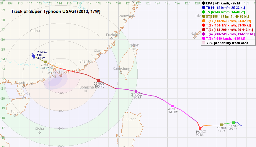
| Maximum 1-minute wind (JTWC) JTWC 一分鐘平均最高中心風速 | 140 knots 節 (Category 5 Super Typhoon 五級超級颱風) |
| Minimum pressure (JTWC) JTWC 最低氣壓 | 918 hPa 百帕 |
| Highest TC signal by HKO (if applicable) 香港天文台發出最高熱帶氣旋警告信號 |
8 (NW, SW) (Gale or Storm Signal 烈風或暴風信號) |
| Closest point of approach by HKO (if applicable) 香港天文台所示之最接近距離 (如適用) |
N 80 km (real-time warning 實時報告 / TC report 熱帶氣旋報告) |
| Time of closest approach by HKO (if applicable) 香港天文台所示之最接近時間 (如適用) |
2013/09/23 01 HKT (real-time warning 實時報告) / 00 HKT (TC report 熱帶氣旋報告) |
| Lowest pressure recorded at HKO (if applicable) 香港天文台錄得的最低氣壓 (如適用) |
985.7 hPa 百帕 (2013/09/22 22:06 HKT) |
TC signals for Hong Kong & Track 香港曾經生效的熱帶氣旋警告和路徑圖:
Table 表:
| Signal 信號 |
Date and time 日期和時間 |
Distance from HK 與香港的距離 |
Predicted movement 預測移動方向和速度 |
Max. 10-min winds 中心最高十分鐘平均風速 |
 |
2013/09/21 (SAT) 10:40 HKT | ESE 760 km | WNW at 18 km/h | 205 km/h (110 knots, CAT. 3 / SuT) |
 |
2013/09/21 (SAT) 23:40 HKT | ESE 530 km | WNW at 18 km/h | 175 km/h (95 knots, CAT. 2 / ST) |
 |
2013/09/22 (SUN) 18:40 HKT | ENE 160 km | WNW at 20 km/h | 165 km/h (90 knots, CAT. 2 / ST) |
 |
2013/09/23 (MON) 00:25 HKT | NNE 80 km | W/WNW at 22 km/h | 155 km/h (85 knots, CAT. 2 / ST) |
|
2013/09/23 (MON) 09:20 HKT | NW 240 km | WNW at 22 km/h | 75 km/h (40 knots, TS) |
 |
2013/09/23 (MON) 10:25 HKT | NW 280 km | WNW at 22 km/h | 55 km/h (30 knots, TD) |
Figure 圖:
(Track courtesy of Lorenzo. Data from HKO. 鳴謝 Lorenzo 提供路徑圖,資料取自天文台)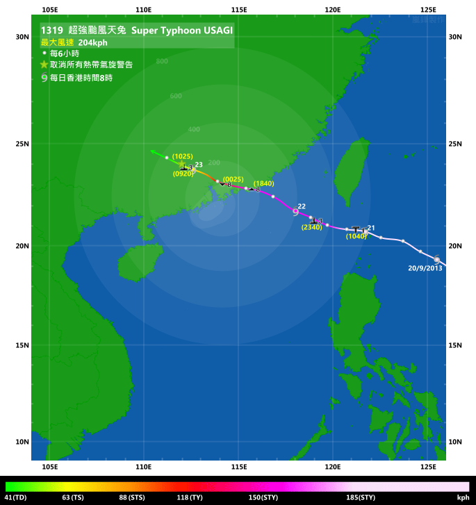
Percentile rank among storms with #8 Signal (at compilation of this review)*: *This measures the relative wind strength in Hong Kong caused by this storm compared with others that share the same signal. 指標顯示此風暴相對於其他發出同樣信號的風暴為香港帶來之風力強度 For more information, please refer to Wind Speed Data for TCs that Have Affected Hong Kong. 更多資訊載於 影響香港氣旋之風速數據 頁 |
Overall: 總計: |
|
Moderately strong 中等偏強 |
|||
| Component Ranks 分部等級 | ||||||
| Reference stations: 參考站: |
|
Moderate 中等 |
||||
| Victoria Harbour: 維多利亞港: |
|
Moderately strong 中等偏強 |
||||
| Urban: 市區: |
|
Moderately strong 中等偏強 |
||||
| Offshore & high ground 離岸和高地: |
|
Moderate 中等 |
||||
Cyclones that attained similar rating (with signal #8): IMBUDO (2003), SIBYL (1995), HELEN (1995), TASHA (1993) 相近級別之熱帶氣旋 (八號信號):伊布都 (2003), 斯寶 (1995), 海倫 (1995), 泰莎 (1993) |
||||||
IR imagery animation 紅外線雲圖動畫:
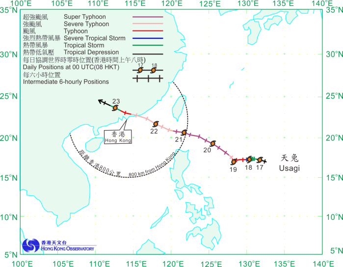
TC track from HKWW 本站的熱帶氣旋路徑圖:
TC track from HKO 天文台的熱帶氣旋路徑圖:
| Past HKWW Bulletins on USAGI 本站有關天兔的發佈 |
Please click here for bulletins on USAGI. 請按這裡。
| Storm Formation and Development 氣旋形成和發展 |
Unless otherwise stated, all times below are in Hong Kong Standard Time (UTC+8)
除非特別註明,下文時間均為香港標準時間 (協調世界時加 8 小時)
Among the storms that affected Hong Kong this year, USAGI was the strongest at its peak.
The development of USAGI was foreseen by numerical models long before its actual formation. As severe tropical storm MAN-YI moved away, the patch of convections within the intertropical convergence zone east of the Philippines started to develop. The JTWC issued a tropical cyclone formation alert in the morning of September 16, and the disturbance was upgraded to tropical depression 17W at 2 am September 17. Perhaps as a result of 17W's clear spiraling characteristics, the JMA upgraded it into a tropical storm at the same time, giving it the name USAGI. This name was contributed by Japan, meaning the constellation Lepus. Meanwhile, the HKO upgraded the area of low pressure into a tropical cyclone in its 3:45 am bulletin.
Due to the passage of MAN-YI, there was very little influence from the subtropical ridge north of USAGI at its formation. This led to its slow and somewhat irregular movement. USAGI moved slowly westwards on September 17, and dipped slightly southwards while it consolidated. The synoptic environment called for a re-strengthening of the ridge which would place USAGI to its south to southwestern periphery, and therefore a general track towards the WNW was anticipated. USAGI was forecast to cross the Luzon Strait and approach southeastern China. It is worth mentioning that the ECMWF model had been consistently forecasting landfall in the vicinity of Hong Kong, both before and after the storm was formed.
USAGI intensified steadily on September 18, reaching severe tropical storm and typhoon strength on the same day. A banding eye appeared and its surrounding area quickly consolidated into a central dense overcast. USAGI moved further south that day and this prompted agencies to shift its forecast track southwards, predicting a landfall close to or even at Hong Kong.
天兔是本年影響香港的熱帶氣旋中巔峰強度最高的一個。
遠在天兔形成之前,數值預報模式已預見其發展。隨著強烈熱帶風暴萬宜遠去,菲律賓以東的熱帶輻合帶中一團環流開始發展。聯合颱風警報中心於 9 月 16 日早上對該擾動發出熱帶氣旋形成警報,隨後於 17 日凌晨 2 時將其升格為熱帶低氣壓 17W。或許因為 17W 旋捲性明顯,日本氣象廳於同時將其升格為熱帶風暴,並命名為天兔。此名字由日本提供,是一星座名稱。另一邊廂,香港天文台在凌晨 3 時 45 分的天氣稿中將該低壓區升格為熱帶氣旋。
由於萬宜先前通過該區,天兔形成時其北面的副熱帶高壓脊影響力甚微,這令天兔移速較慢,路徑亦稍為不規則。天兔於 17 日向西緩慢移動,並於整合期間稍為南移。大氣形勢有利副高重新發展,令天兔處於其南至西南沿,因此預料天兔會向西北偏西移動,橫過呂宋海峽,繼而趨向中國東南部。值得一提的是歐洲中期天氣預報模式於天兔形成前後皆多次預測將有熱帶氣旋登陸香港附近。
天兔於 18 日穩定增強,於同日達到強烈熱帶風暴及颱風強度。雲捲風眼形成,其周邊區域迅速整固為中心密集雲區。當天天兔繼續南移,各機構紛紛將其預測路徑南調,令登陸點更為靠近甚至直趨香港。

Figure 1 - ECMWF prediction on September 15 showing a tropical cyclone making landfall at Hong Kong 8 days later. Source: Here
圖 1 - 9 月 15 日歐洲中期天氣預報模式顯示一熱帶氣旋於 8 日後將登陸香港。來源:按此

Figure 2 - USAGI at formation
圖 2 - 天兔正在形成

Figures 3a to 3b - Forecast tracks from official agencies on September 17 and 20
圖 3a 及 3b - 官方氣象台於 9 月 17 及 20 日的預測路徑
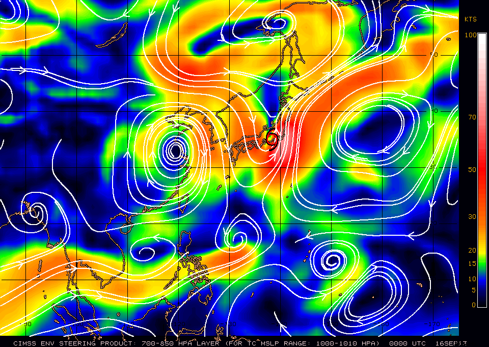
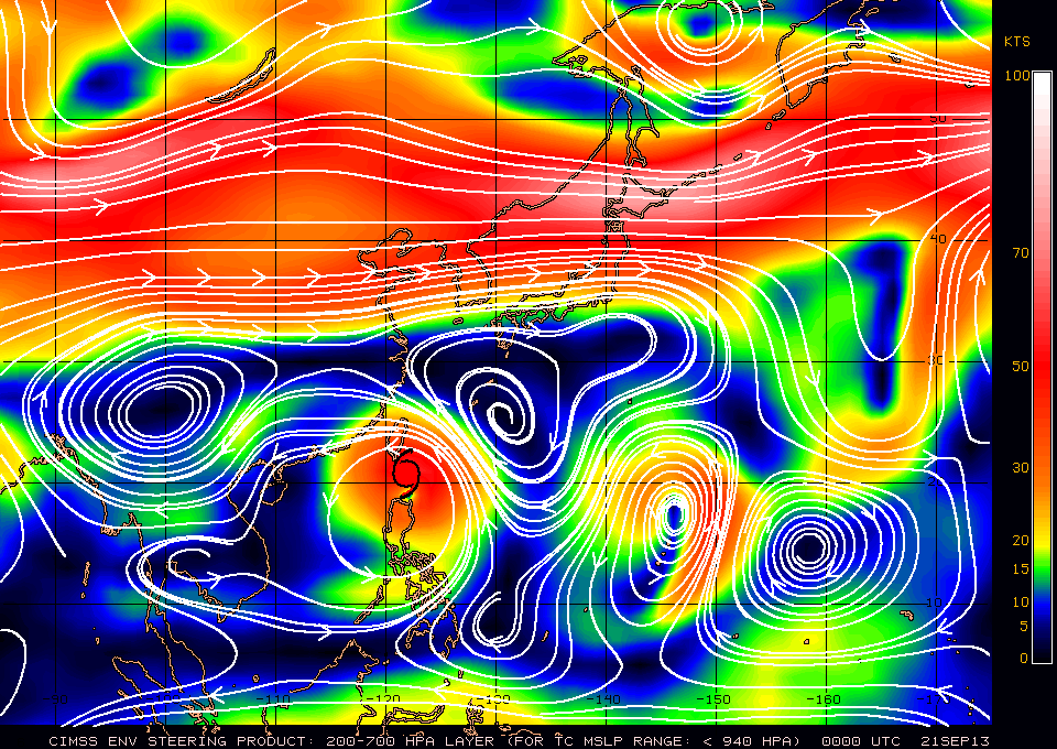
Figures 4a and 4b - Steering flow charts on September 16 and 21
圖 4a 及 4b - 9 月 16 及 21 日之駛流圖
| Intensification and Crossing Luzon Strait 增強及橫過呂宋海峽 |
USAGI intensified rapidly on September 19 as its eye enlarged and the eyewall expanded. The JTWC adjusted its intensity estimate upwards from 90 to 105 knots at 8 am, and further to 120 knots at 2 pm. USAGI's eyewall cloud top temperatures dropped to -80 degrees and the eye became clear of clouds. The intensity was increased to 140 knots at 8 pm, making USAGI the first category 5 super typhoon in the NW Pacific this year. The HKO, meanwhile, upgraded USAGI into severe typhoon at 1 pm that day and super typhoon at 7 pm. The NASA dubbed USAGI "monster storm" due to its powerful nature. A TRMM scan revealed an eyewall tower protruding to beyond 14 km when USAGI was at its peak intensity.
By September 19 the subtropical ridge has re-established and USAGI started to move NW. Since the storm was not expected to make landfall before reaching the South China Sea, it posed a severe threat to southern China. Together with the possibility of a direct hit, the storm received immense public attention. The Observatory posted a blog entry in its website on that day which explained the track uncertainty and the difference in its influence between a landfall east and west of Hong Kong.
As USAGI moved north, it edged closer to the subtropical ridge. It accelerated to around 20 km/h and turned WNW gradually. The CWB issued the sea warning at 11:30 pm September 19 as USAGI neared the island. This was upgraded to the sea and land warning at 8:30 am the next day as the force 7 was expected to reach southern Taiwan soon. USAGI apparently entered an eyewall replacement cycle in the afternoon of September 20. Its eyewall cloud top temperatures rose and the central dense overcast was "pushed" inward, leaving a gap with thinner convections. The JTWC downgraded it into a category 4 super typhoon at 2 pm. It lost the super typhoon status 18 hours later.
USAGI passed Luzon Strait on September 21 and was travelling more equatorward than the previous day. Model and official forecasts continued to put USAGI's landfall position at or near Hong Kong. The Observatory included a warning message in its hourly temperature bulletin, stating that USAGI was a mature typhoon that might become the strongest one to affect Hong Kong this year. It also urged citizens to complete precautionary measures even before the issuance of tropical cyclone signals.
天兔於 9 月 19 日迅速增強,其風眼及眼牆均擴大。聯合颱風警報中心將其強度估計由 90 節調高至上午 8 時之 105 節,6 小時後更調高至 120 節。天兔的眼牆雲頂溫度下降至 -80 度,風眼則清晰無雲。當晚 8 時其強度被調升至 140 節,使它成為本年西北太平洋首個五級超級颱風。本港方面,天文台於分別於下午 1 時及 7 時將天兔升格為強颱風及超強颱風。美國太空總署形容天兔為「怪獸風暴」,TRMM 掃描曾顯示天兔的眼牆高度足有 14 公里。
副高於 19 日已再次發展,天兔開始向西北移。由於預測進入南海前不會登陸,它對華南威脅較嚴重,加上天兔有機會直趨本港,市民大眾十分關心其發展。天文台當天於其網誌發表文章,解釋天兔路徑之不確定性,並闡述熱帶氣旋於香港以東及以西登陸對香港造成的影響之分別。
由於天兔北移至較為接近副高邊沿,它加速至每小時約 20 公里,並向逐漸轉為向西北偏西移動。隨著天兔靠近,台灣中央氣象台於 19 日晚上 11 時 30 分發出海上颱風警報,並於翌日上午 8 時 30 分,當七級風圈進一步逼近台灣南部時加發陸上警報。天兔於 20 日開始眼牆置換週期,雲頂溫度上升,而中心密集雲區看似被推往中心,露出一條雲帶較薄的空隙。聯合颱風警報中心於下午 2 時將天兔降格為四級超級颱風,18 小時後失去超級颱風地位。
天兔於 21 日橫過呂宋海峽,相對於前一日其移動路徑更為偏西。數值模式及官方預報均繼續將天兔的登陸點聚焦至香港一帶。天文台於其每小時溫濕度報告中加入天兔可能為今年影響本港最強的熱帶氣旋之信息,並於熱帶氣旋警告信號發出前提醒市民做好防風措施。

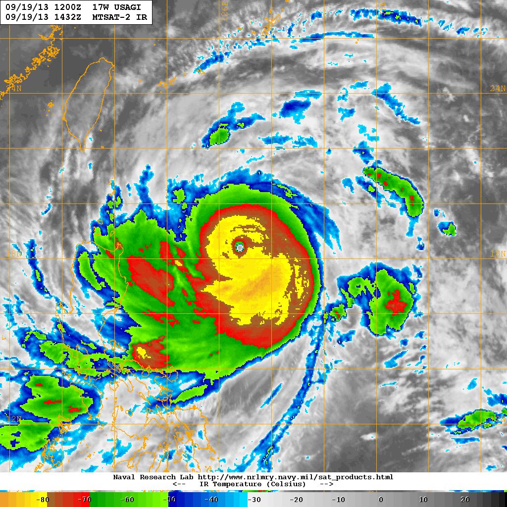
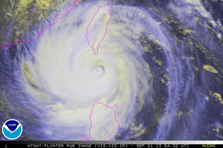
Figures 5a and 5b - USAGI at peak intensity
圖 5a 及 5b - 天兔達到其巔峰強度

Figure 5c - TRMM scan when USAGI was at peak intensity
圖 5c - 天兔達到巔峰強度時的 TRMM 掃描

Figure 6 - Wind field associated with USAGI in the morning of September 20
圖 6 - 9 月 20 日早上天兔的風場
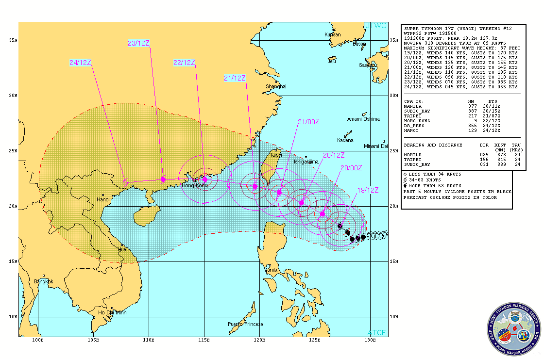
Figure 7 - One of the many JTWC bulletins that depicted a direct hit on Hong Kong
圖 7 - 聯合颱風警報中心眾多預測天兔直趨香港的發佈之一

Figures 8a and 8b - USAGI exhibited a double eyewall feature as it crossed Luzon Strait
圖 8a 及 8b - 天兔橫過呂宋海峽時出現雙重眼壁結構
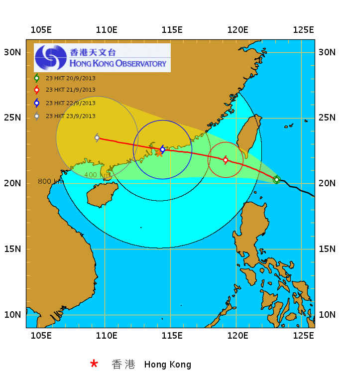

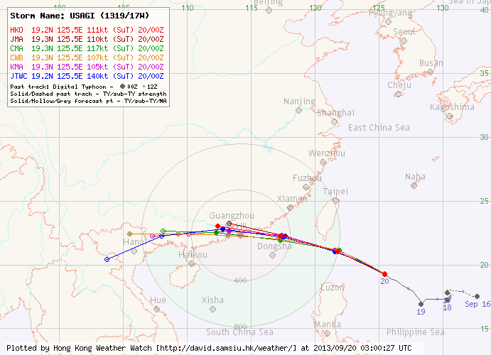
Figures 9a and 9b - HKO's forecast tracks showing a close encounter. Note USAGI's wide wind radii.
圖 9a 及 9b - 天文台預測天兔會非常接近本港,留意其風圈頗大
| Approaching South China Coastal Areas 靠近華南沿岸 |
USAGI crossed Luzon Strait at an intensity of between category 3 and category 4. It came to within 800 km of Hong Kong in the morning of September 21. The Observatory issued the #1 Standby Signal at 10:40 am when USAGI was situated 760 km ESE of the territory. Since USAGI came close just after the mid-autumn festival, tide levels were expected to be higher which could potentially make flooding more serious in low-lying areas. Soon after the issuance of the signal, container terminal operators announced that the handling of empty cargos would be suspended at 5 pm, and that of laden cargos at 8 pm.
Even though USAGI did not make landfall, land interaction was still apparent. Its structure deteriorated especially in its northern semicircle. The Observatory downgraded USAGI into a severe typhoon at 9 pm. As USAGI approached Hong Kong from the east, northerly winds were prevalent. Most places were well sheltered and winds did not pick up substantially. Nevertheless the Observatory issued the #3 Strong Wind Signal at 11:40 pm to warn the public that winds could strengthen rapidly the next day. At the time of signal issuance, strong winds were only recorded at Tate's Cairn.
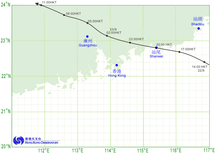
USAGI moved further north than predicted on September 22. By daybreak it became clear that USAGI would make landfall east of Hong Kong, which would mean smaller damage. However, it was still quite possible for the storm to get very close to Hong Kong. The Observatory indicated in the tropical cyclone bulletin at 7 am that it would consider higher signals in the afternoon or evening. Because of the advance warning that USAGI could get very close, various service suspensions were already announced or scheduled even before the Pre-No. 8 Announcement, such as flights to and from Hong Kong, hydrofoil services between Hong Kong and Macau and local ferry services.
Locally, USAGI's rainbands arrived in the late morning, and wind direction turned northwest in the afternoon. Winds started to pick up substantially; strong force winds were reached at Cheung Chau, Green Island, Peng Chau, Sha Chau and Waglan Island, while Tate's Cairn was blowing gale force winds. USAGI reached Hong Kong's latitude at 3 pm, technically ruling out the possibility of a landfall west of the territory. As the surge in wind speed was rather rapid, the Observatory issued the Pre-No. 8 Special Announcement at 4:40 pm and stated that the #8 Signal would be issued by 7 pm the latest. The Star Ferry announced that the cross-harbour ferry service would be suspended at 7:40 pm, while bus companies scheduled service suspensions two hours after the #8 Signal was issued. Crosswinds at the airport led to many flights being suspended.
Winds strengthened again between 5 and 7 pm, and winds at several stations reached gale force level, including Cheung Chau, Tap Mun and Waglan Island. The #8 Northwest Gale or Storm Signal was issued at 6:40 pm, when USAGI was 160 km ENE of Hong Kong. Stronger rainbands struck Hong Kong near 7 pm and winds picked up accordingly. According to Chinese authorities, USAGI made landfall at Shanwei, Guangdong at 7:40 pm as a severe typhoon, carrying winds of around 45 m/s (162 km/h).
Upon landfall, USAGI weakened more rapidly as was evident from radar images. However, it continued to approach Hong Kong since it was still travelling WNW. Winds in Hong Kong were strongest between 9 pm and 3 am the next day, depending on whether the station is more exposed towards the northwest or southwest. Wind direction backed to the west at around 10 pm and to southwest at around 1 am. During this period winds generally reached gale force, while several offshore and highground stations (including Cheung Chau, Ngong Ping, Tate's Cairn and Waglan Island) registered storm force winds. There was no significant increase in wind speed after midnight, which ruled out the necessity of the #9 Signal. Rainbands associated with USAGI continued to affect most parts of the territory during the night, dumping rain of more than 30 mm per hour at times.
USAGI was closest to Hong Kong near midnight September 23, when it passed 80 km to the north of the Observatory. Highest tides were recorded between 10 pm and midnight; the levels at Quarry Bay and Tsim Bei Tsui were 2.8 and 3.5 m respectively, and were 0.6 and 1.0 m above normal. As winds turned southwest, the #8 Northwest Signal was replaced by the Southwest Signal at 12:25 am. USAGI was downgraded into a typhoon at 1 am, when it had already been travelling inland for 5 hours.
天兔以三至四級颱風強度橫過呂宋海峽,並於 9 月 21 日早上進入香港 800 公里範圍。天文台於上午 10 時 40 分發出一號戒備信號,當時天兔位處本港東南偏東約 760 公里。由於天兔於中秋節後不久靠近,預測水位可能會更高,低窪地區水浸或將較為嚴重。一號信號發出後不久,各貨櫃碼頭公司宣布當天下午 5 時暫停吉櫃交收,而重櫃交收亦會於當晚 8 時暫停。
雖然天兔並未登陸,但陸地影響還是明顯,其結構開始轉差,尤以北半圓為甚。天文台於下午 9 時將天兔降格為強颱風。由於天兔於東面靠近香港,本港普遍吹北風,受地形屏蔽風速未有明顯上升,但天文台於晚上 11 時 40 分改發三號強風信號,用以警示市民風勢將於翌日明顯增強。三號信號發出之時,只有大老山吹強風。
天兔於 22 日的移向比預測為北。至破曉時份已幾乎肯定它將於香港以東登陸,對本地的影響相對較小,但天兔仍有機會於香港近處掠過。天文台於上午 7 時的熱帶氣旋警報中表示將於當天下午至黃昏改發八號信號。由於較早前已預測天兔或會非常接近香港,八號信號預警發出前已有不少預計服務暫停的消息,如抵港及離港航班、來往港澳的水翼船及本地渡輪的服務。
天兔的雨帶於上午後段到達香港,風向則於下午逆轉至西北。各區風勢開始明顯加強,長洲、青洲、坪洲、沙洲及橫瀾島錄得強風,而大老山則吹烈風。天兔於下午 3 時到達香港的緯度,即肯定會於香港以東登陸。由於風速上升速度頗快,天文台於下午 4 時 40 分發出預警八號熱帶氣旋警告信號之特別報告,表示最遲會於下午 7 時發出八號信號。天星小輪隨即宣布其渡輪服務將於下午 7 時 40 分起暫停,而巴士公司則宣布服務將於八號信號發出後兩小時暫停。受側風影響,不少航班被取消。
風力於下午 5 至 7 時期間再次增強,長洲、塔門及橫瀾島吹烈風。八號西北烈風或暴風信號於下午 6 時 40 分發出,當時天兔位於香港東北偏東約 160 公里。較強的雨帶於下午 7 時左右掃過香港,風勢進一步增強。根據中國當局資料,天兔於下午 7 時 40 分以強颱風強度登陸廣東汕尾,登陸時中心風速達每秒 45 米 (每小時 162 公里)。
登陸後,天兔減弱速度更快,從雷達圖可清楚見到。但是,由於天兔向西北偏西移動,它仍然在靠近香港中。本港風力於當晚 9 時至翌日凌晨 3 時最強,確實時間視乎該站西北抑或西南面較為當風。風向於晚上 10 時逆轉至偏西,至凌晨 1 時轉吹西南風,期間風力普遍達烈風程度,部分離岸及高地站如長洲、昂坪、大老山及橫瀾島則吹暴風。午夜後風勢未有進一步增強,因此九號信號未需發出。天兔的雨帶於凌晨繼續影響本港大部分地區,部分區域曾錄得每小時超過 30 毫米雨量。
天兔於 23 日午夜左右最接近本港,於天文台以北約 80 公里掠過。最高潮水位於晚上 10 時至凌晨 12 時錄得,鰂魚涌及尖鼻咀的最高海水高度分別為 2.8 及 3.5 米,比正常高 0.6 及 1.0 米。隨著風向逆轉,天文台於凌晨 12 時 25 分改發八號西南烈風或暴風信號。天兔於上午 1 時被降格為颱風,當時它已登陸了 5 小時。

Figure 10 - HKO's numerical model once predicted a direct hit
圖 10 - 天文台的數值模式曾預測天兔直趨香港

Figure 11 - Sea level pressure distribution in southern China a few hours after USAGI made landfall
圖 11 - 天兔登陸後數小時華南海平面氣壓分布

Figure 12 - Satellite image at USAGI's closest approach to Hong Kong
圖 12 - 天兔最接近香港時之衛星雲圖


Figures 13a and 13b - Calculated wind fields at 8 pm September 22 and 2 am the next day
圖 13a 及 13b - 9 月 22 日晚上 8 時及翌日凌晨 2 時之估算風場圖
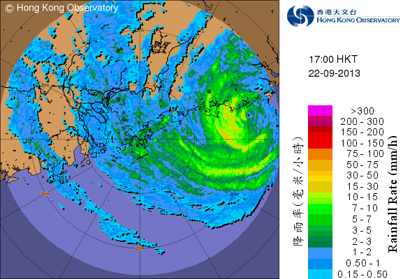


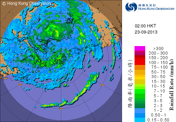
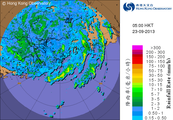
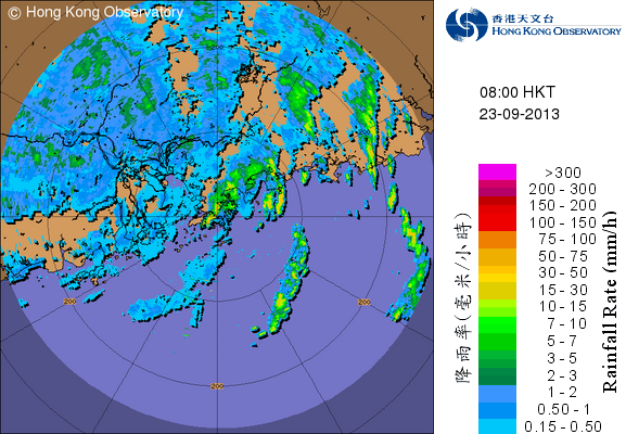
Figures 14a to 14f - Radar images at 3-hour intervals from 5 pm September 22 to 8 am the next day
圖 14a 至 14f - 9 月 22 日下午 5 時至翌日上午 8 時每三小時的雷達圖


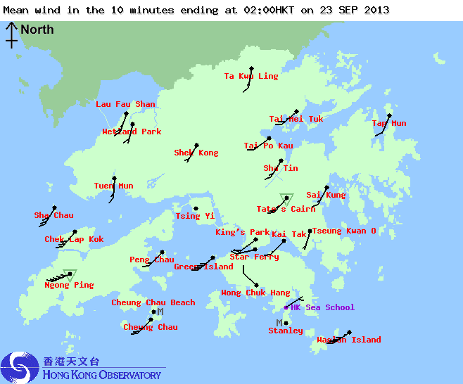

Figures 15a to 15f - Local wind distribution maps at 3-hour intervals from 5 pm September 22 to 8 am the next day
圖 15a 至 15f - 9 月 22 日下午 5 時至翌日上午 8 時每三小時的本港風勢分布圖


Figures 16a to 16d - Wind speed time series at Cheung Chau, Lau Fau Shan, Chek Lap Kok and Waglan Island
圖 16a 至 16d - 長洲、流浮山、赤鱲角及橫瀾島的風速時間序列圖
| Rapid Weakening and Dissipation 急速減弱及消散 |
The Observatory warned that the change in wind direction would result in stronger winds at locations exposed to the southwest. However, the subsequent southwesterly winds were not as strong as expected, probably because USAGI was weakening quickly. Wind speeds declined sharply after 3 am September 23, and by 5 am only a handful of stations were still registering gale force winds. The Observatory indicated that the #8 Signal would be lifted by 10 am if winds dropped to below gale force. Most workers would hence get an extra few hours of rest before having to return to work by late morning.
USAGI weakened into a severe tropical storm at 6 am. Although it was less than 200 km from Hong Kong, by 7 am winds in Hong Kong were so light that even a #3 Signal would seem unnecessary. However, the Observatory erred on the side of caution and waited a few more hours before replacing the #8 Signal by the #3 Strong Wind Signal at 9:20 am. This was in stark contrast to the treatment of typhoon UTOR, when the signal was cancelled while winds were strengthening. Following the signal change, various services across the territory resumed gradually. By the time the #3 Signal was on, USAGI had already weakened into a tropical storm.
The #3 Signal did not last long and was cancelled at 10:25 am. Due to the lack of moisture supply, USAGI weakened quickly into a tropical depression and dissipated in the afternoon.
Because of the relatively brief influence and landfall east of Hong Kong, USAGI did not cause much damage to the territory. 17 people were injured and sought medical treatment at the Accident and Emergency Departments at public hospitals during the passage of USAGI; there were more than 100 reports of fallen trees; more than 200 flights were delayed and another 200 cancelled. On September 28, the Observatory posted another blog entry which commented on how lucky Hong Kong was as USAGI did not make landfall west of the territory. A simulation was run assuming USAGI's track was 100 km south of its actual track (i.e. passing Hong Kong). If that was the case, the sea level at Quarry Bay would reach 4 m. This would be almost the same as the storm surge level during the impact of typhoon WANDA in 1962, which could potentially result in much more serious damage.
天文台警告風向轉變或會令先前被遮蔽的地方變得當風,但最終西南風並沒有預計般強,這可能是因為天兔登陸後迅速減弱。風勢於 23 日凌晨 3 時過後插水式下降,至清晨 5 時只有三兩氣象站仍吹烈風,天文台因此表示如風勢下降至烈風強度以下,八號信號會於 10 時前被三號信號取代,大部分打工仔因此可多休息數小時,但將要於早上末段開始上班。
天兔於早上 6 時減弱為強烈熱帶風暴。雖然它與香港的距離不足 200 公里,但至上午 7 時本港風勢已經非常弱,甚至連三號信號風力亦不及。天文台採取較安全的策略,待至上午 9 時 20 分風勢已持續於較弱水平一段時間後才改發三號強風信號。這與颱風尤特襲港時,天文台於風力上升時取消八號信號的做法截然不同。八號信號取消後,各服務陸續恢復正常。天兔亦於三號信號生效前減弱為熱帶風暴。
三號信號維持了短短 65 分鐘便於上午 10 時 25 分被取消。由於缺乏水氣供應,天兔快速減弱為熱帶低氣壓,並於下午消散。
由於天兔於香港以東登陸且影響香港時間較為短暫,它對香港造成的破壞較輕微。風暴襲港時 17 人受傷並前往公立醫院急症室求診;當局收到超過 100 宗塌樹報告,逾 200 航班延期,另 200 班則取消。9 月 28 日,天文台發佈另一篇網誌,表示香港是次非常幸運,天兔並未於香港以西登陸。天文台利用電腦模擬天兔採取較實際偏南 100 公里的路線時 (即經過本港) 的情境,發現鰂魚涌的水位將上升至 4 米,與 1962 年颱風溫黛襲港時相若,屆時後果將非常嚴重。

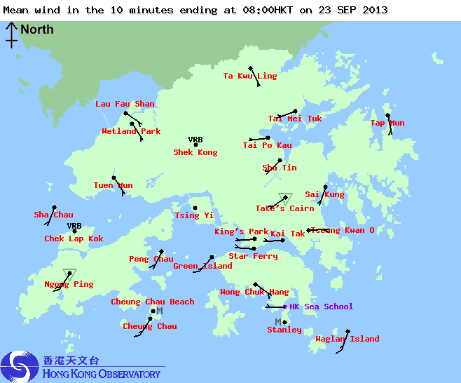
Figure 17 - Screen capture of HKO's website in the morning of September 23. Although the #8 Signal was still in effect, none of the wind barbs showed even strong winds.
圖 17 - 9 月 23 日清晨天文台網頁的截圖,可見雖然八號信號仍然生效,但各區風力連強風也未達。
| Winds Recorded at Reference Stations 參考站所錄得的風速 |
| Station 風速站 |
Max. 10-min avg. wind speed 最高十分鐘平均風速 |
Beaufort classification 蒲福氏風級分類 |
| Chek Lap Kok 赤鱲角 | 68 km/h | GALE 烈風 |
| Cheung Chau 長洲 | 90 km/h | STORM 暴風 |
| Kai Tak 啟德 | 51 km/h | STRONG 強風 |
| Lau Fau Shan 流浮山 | 85 km/h | GALE 烈風 |
| Sai Kung 西貢 | 40 km/h | Fresh 清勁 |
| Sha Tin 沙田 | 37 km/h | Fresh 清勁 |
| Ta Kwu Ling 打鼓嶺 | 35 km/h | Fresh 清勁 |
| Tsing Yi (SHL) 青衣蜆殼油庫 | 52 km/h | STRONG 強風 |
| Number of stations recording at least STRONG force (force 6 - 7) winds: | 5 |
| Number of stations recording at least GALE force (force 8 - 9) winds: | 3 |
| Number of stations recording at least STORM force (force 10 - 11) winds: | 1 |
| Number of stations recording HURRICANE force (force 12) winds: | 0 |
| 錄得 強風 (6 - 7 級) 或更高風速的站數: | 5 |
| 錄得 烈風 (8 - 9 級) 或更高風速的站數: | 3 |
| 錄得 暴風 (10 - 11 級) 或更高風速的站數: | 1 |
| 錄得 颶風 (12 級) 風速的站數: | 0 |
| Charts and Figures 各項數據 |
Table 1: Track data from HKWW:
表一 : 香港天氣觀測站之路徑資料
YYMMDDZZ Lat Long Wind |
Table 2: Track data from JTWC:
表二 : 聯合颱風警報中心之路徑資料
ID Name YYMMDD ZZZZ Lat Long Basin Wind Pres 17W USAGI 130923 0600 24.0N 111.0E WPAC 35 996 |
Table 3: Maximum gust and hourly average wind speed recorded in Hong Kong from HKO:
表三 : 香港天文台公佈的各站最高每小時平均風力和陣風數據
| Station | Maximum Gust | Maximum Hourly Mean Wind | ||||||
| Direction | Speed (km/h) | Date/ Month |
Time | Direction | Speed (km/h) | Date/ Month |
Time | |
| Central Pier | W | 94 | 22/9 | 22:33 | W | 51 | 22/9 | 22:00 |
| Cheung Chau | WNW | 128 | 22/9 | 21:34 | WNW | 83 | 22/9 | 22:00 |
| Cheung Chau Beach | W | 112 | 22/9 | 21:34 | W | 62 | 22/9 | 22:00 |
| Green Island | NW | 103 | 22/9 | 22:07 | WSW | 72 | 23/9 | 02:00 |
| Hong Kong International Airport | SSW | 87 | 23/9 | 01:14 | W | 65 | 22/9 | 23:00 |
| Kai Tak | WSW | 83 | 22/9 | 23:11 | W | 47 | 22/9 | 21:00 |
| King's Park | WNW | 88 | 22/9 | 23:25 | WNW | 34 | 22/9 | 23:00 |
| Lau Fau Shan | W | 112 | 22/9 | 22:38 | W | 79 | 23/9 | 00:00 |
| Ngong Ping | W | 133 | 23/9 | 00:03 | WSW | 83 | 23/9 | 02:00 |
| North Point | WSW | 99 | 22/9 | 22:21 | W | 63 | 22/9 | 23:00 |
| Peng Chau | WNW | 101 | 22/9 | 21:02 | NW | 59 | 22/9 | 20:00 |
| Ping Chau | W | 94 | 22/9 | 22:12 | W | 51 | 22/9 | 23:00 |
| Sai Kung | WNW | 88 | 22/9 | 18:58 | NW | 34 | 22/9 | 21:00 |
| Sha Chau | SSW | 90 | 23/9 | 02:51 | SSW | 56 | 23/9 | 03:00 |
| Sha Lo Wan | SW | 96 | 23/9 | 01:07 | WSW | 41 | 23/9 | 00:00 |
| Sha Tin | SW | 68 | 23/9 | 00:13 | SW | 31 | 23/9 | 01:00 |
| Stanley | W | 121 | 22/9 | 23:09 | W | 76 | 23/9 | 00:00 |
| Shek Kong | SW | 62 | 22/9 | 23:29 | WSW | 25 | 23/9 | 00:00 |
| Star Ferry (Kowloon) | W | 101 | 23/9 | 01:48 | W | 72 | 22/9 | 23:00 |
| Ta Kwu Ling | WSW | 68 | 22/9 | 23:23 | WSW | 31 | 23/9 | 00:00 |
| Tai Mei Tuk | WSW | 121 | 22/9 | 20:09 | W | 62 | 22/9 | 23:00 |
| Tai Mo Shan | W | 155 | 22/9 | 22:43 | W | 118 | 22/9 | 23:00 |
| Tai Po Kau | WNW | 103 | 22/9 | 22:21 | W | 52 | 22/9 | 23:00 |
| Tap Mun | W | 115 | 22/9 | 21:06 | W | 68 | 22/9 | 22:00 |
| Tate's Cairn | NNW | 140 | 22/9 | 20:13 | NW | 79 | 22/9 | 21:00 |
| Tseung Kwan O | NW | 58 | 22/9 | 18:43 | W | 19 | 22/9 | 21:00 |
| Tsing Yi Shell Oil Depot | - | 90 | 22/9 | 21:37 | - | 49 | 22/9 | 22:00 |
| Tuen Mun Government Offices | NW | 112 | 22/9 | 22:05 | WNW | 40 | 22/9 | 23:00 |
| Waglan Island | WSW | 110 | 22/9 | 23:50 | WSW | 87 | 23/9 | 00:00 |
| Wetland Park | WNW | 65 | 22/9 | 22:23 | NW | 25 | 22/9 | 19:00 |
| Wong Chuk Hang | WNW |
99 |
22/9 |
21:11 | WNW |
34 |
22/9 |
22:00 |
Table 4: Rainfall (in millimetres) contributed by USAGI from HKO (figures in brackets are based on incomplete hourly data):
表四 : 香港天文台公佈的各站雨量資料 (方括號內之數據由不完整之每小時資料擷取)
| Station | 21 Sep |
22 Sep |
23 Sep |
Total rainfall(mm) |
|
| Hong Kong Observatory | 0.0 |
30.6 |
56.9 |
87.5 |
|
| Hong Kong International Airport (HKA) | 0.0 |
17.6 |
88.5 |
106.1 |
|
| Cheung Chau (CCH) | 0.0 |
23.5 |
57.0 |
80.5 |
|
| H23 | Aberdeen | 0.0 |
12.0 |
50.0 |
62.0 |
| N05 | Fanling | 0.0 |
38.5 |
88.5 |
127.0 |
| N13 | High Island | 0.0 |
60.5 |
29.0 |
89.5 |
| K04 | Jordan Valley | 0.0 |
49.5 |
66.5 |
116.0 |
| N06 | Kwai Chung | 0.0 |
66.0 |
108.0 |
174.0 |
| H12 | Mid Levels | 0.0 |
31.0 |
52.0 |
83.0 |
| N09 | Sha Tin | 0.0 |
56.5 |
94.0 |
150.5 |
| H19 | Shau Kei Wan | 0.0 |
32.5 |
60.0 |
92.5 |
| SEK | Shek Kong | 0.0 |
45.5 |
56.0 |
101.5 |
| K06 | So Uk Estate | 0.0 |
53.0 |
71.5 |
124.5 |
| R31 | Tai Mei Tuk | 0.0 |
59.5 |
57.5 |
117.0 |
| R21 | Tap Shek Kok | 0.0 |
21.5 |
52.5 |
74.0 |
| N17 | Tung Chung | 0.0 |
29.5 |
124.0 |
153.5 |
| R27 | Yuen Long | 0.0 |
39.0 |
72.0 |
111.0 |
Last Accessed 最近訪問日期: Thu Apr 18 2024 17:05:38 HKT
Last Modified 最近修訂日期: Mon Jul 24 2023
