TC Watch / 熱帶氣旋
> Latest TC Info 最新熱帶氣旋資訊 [Refresh 更新 ]
Current
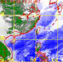
TC Map 即時氣旋資訊
1. 05W (PEIPAH 琵琶)
Name of System 系統名稱
TD PEIPAH 熱帶低氣壓 琵琶
JTWC No. / Int'l No. JTWC
編號 / 國際編號
05W / 1404
Bulletin Number 發佈編號
#9 FINAL BULLETIN 最後發佈
Time of
Report 報告時間
2014/04/11, 12:00 HKT (04:00 UTC)
Time of
Observation 觀測時間
2014/04/11,
08:00 HKT (00:00 UTC)
Position 位置
9.3°N, 131.5°E
Maximum Gust 最高陣風
35 knots 節 (65 km/h 公里每小時)
1-min. Average Wind Speed 1分鐘平均風速
25 knots 節 (45 km/h 公里每小時)
10-min. Average Wind Speed 10分鐘平均風速
20 knots 節 (35 km/h 公里每小時)
Pressure 氣壓
1006 hPa 百帕斯卡
Past 6-hr Movement 過去6小時移向和移速
N 北 (360°) at 3 knots 節 (6 km/h 公里每小時)
Area(s) affected 受影響地區
Seas W of Palau 帛琉以西海域
Forecast
Track 預測路徑圖
Forecast
Positions 預測位置資料
Tau HK Time Lat. Long. Movement 1-min Average Strength t+0 04/11 (Fri) 08:00 9.3°N 131.5°E NNW 西北偏北 (327°) 3 km/h 25 kt (46 km/h) TD 熱帶低氣壓 t+12 04/11 (Fri) 20:00 9.6°N 131.3°E N/A 20 kt (37 km/h) LPA 低壓區
Overview 總覽
PEIPAH continues to move slowly. At 8 am, PEIPAH was centred about 1290 km (690 NM) ESE of Manila.
琵琶繼續緩慢移動。在上午 8 時, 琵琶集結在馬尼拉東南偏東約 1290 公里 (690 海里)。
TC
Naming 氣旋命名
PEIPAH is the 49th name in the tropical cyclone name list. It was contributed by Macau, and is a popular pet fish there. This name was used in 2007.
琵琶為熱帶氣旋名稱列表中第 49 個名字,由澳門提供,為當地一種受歡迎的寵物魚。此名曾於 2007 年使用。
Movement
Analysis 路徑分析
Due to weak steering, PEIPAH will continue to drift slowly in the next 24 hours.
由於流場較弱,預料琵琶將於未來 24 小時繼續緩慢移動。
Intensity
Analysis 強度分析
Current T-number 現時的 T 號碼: T1.5/1.5/W0.5/24 HRS
PEIPAH continues to lose strength, and is expected to weaken into an area of low pressure soon.
琵琶繼續減弱,預料短期內減弱為低壓區。
Effects on
Hong Kong 對香港的影響
No threat to Hong Kong is expected within the next 72 hours.
預料琵琶於未來的 72 小時將不會對香港構成影響。
Next Update
下次更新
This is the final bulletin on PEIPAH.
這是本站對琵琶的最後一次發佈。
Other Images
其他圖像
Probabilities
of TC Signals from HKO 香港天文台發出 / 取消熱帶氣旋警告信號的機率
N/A 不適用
Name of System 系統名稱
TD PEIPAH 熱帶低氣壓 琵琶
JTWC No. / Int'l No. JTWC
編號 / 國際編號
05W / 1404
Bulletin Number 發佈編號
#8
Time of
Report 報告時間
2014/04/10, 15:45 HKT (07:45 UTC)
Time of
Observation 觀測時間
2014/04/10,
14:00 HKT (06:00 UTC)
Position 位置
8.5°N, 131.6°E
Maximum Gust 最高陣風
40 knots 節 (75 km/h 公里每小時)
1-min. Average Wind Speed 1分鐘平均風速
30 knots 節 (55 km/h 公里每小時)
10-min. Average Wind Speed 10分鐘平均風速
25 knots 節 (45 km/h 公里每小時)
Pressure 氣壓
1004 hPa 百帕斯卡
Past 6-hr Movement 過去6小時移向和移速
NE 東北 (056°) at 4 knots 節 (7 km/h 公里每小時)
Area(s) affected 受影響地區
Seas W of Palau 帛琉以西海域
Forecast
Track 預測路徑圖
Forecast
Positions 預測位置資料
Tau
HK Time
Lat.
Long.
Movement
1-min Average Strength
t+0
04/10 (Thu) 14:00
8.5°N
131.6°E
N 北 (360°) 1 km/h
30 kt (56 km/h)
TD 熱帶低氣壓
t+12
04/11 (Fri) 02:00
8.6°N
131.6°E
NNW 西北偏北 (342°) 3 km/h
30 kt (56 km/h)
TD 熱帶低氣壓
t+24
04/11 (Fri) 14:00
8.9°N
131.5°E
NW 西北 (324°) 5 km/h
25 kt (46 km/h)
TD 熱帶低氣壓
t+36
04/12 (Sat) 02:00
9.3°N
131.2°E
NW 西北 (310°) 7 km/h
25 kt (46 km/h)
TD 熱帶低氣壓
t+48
04/12 (Sat) 14:00
9.8°N
130.6°E
N/A
20 kt (37 km/h)
LPA 低壓區
Overview 總覽
PEIPAH has weakened and turned eastwards. At 2 pm, PEIPAH was centred about 1340 km (720 NM) ESE of Manila.
琵琶減弱並東移。在下午 2 時, 琵琶集結在馬尼拉東南偏東約 1340 公里 (720 海里)。
TC
Naming 氣旋命名
PEIPAH is the 49th name in the tropical cyclone name list. It was contributed by Macau, and is a popular pet fish there. This name was used in 2007.
琵琶為熱帶氣旋名稱列表中第 49 個名字,由澳門提供,為當地一種受歡迎的寵物魚。此名曾於 2007 年使用。
Movement
Analysis 路徑分析
PEIPAH is in a region with very little steering. It also appears to have multiple competing vortices, which adds to the difficulty in locating the storm and predicting its future movement. A general track to NW is expected, but confidence is low.
琵琶附近流場非常弱,加上它似乎有數個渦旋,增加定位及路徑預測的難度。預料琵琶仍大致會向西北移動,但此佈信心偏低。
Intensity
Analysis 強度分析
Current T-number 現時的 T 號碼: T2.0/2.0/S0.0/24 HRS
The high shear in PEIPAH's vicinity is expected to weaken the storm into an area of low pressure by t+48.
琵琶附近的高垂直風切變將繼續令系統減弱,預料它會於 48 小時內減弱為低壓區。
Effects on
Hong Kong 對香港的影響
No threat to Hong Kong is expected within the next 72 hours.
預料琵琶於未來的 72 小時將不會對香港構成影響。
Next Update
下次更新
2014/04/11 (Fri 五), afternoon 下午 (or earlier 或更早)
Other Images
其他圖像
Probabilities
of TC Signals from HKO 香港天文台發出 / 取消熱帶氣旋警告信號的機率
N/A 不適用
Name of System 系統名稱
TS PEIPAH 熱帶風暴 琵琶
JTWC No. / Int'l No. JTWC
編號 / 國際編號
05W / 1404
Bulletin Number 發佈編號
#7
Time of
Report 報告時間
2014/04/09, 16:00 HKT (08:00 UTC)
Time of
Observation 觀測時間
2014/04/09,
14:00 HKT (06:00 UTC)
Position 位置
8.3°N, 130.2°E
Maximum Gust 最高陣風
45 knots 節 (85 km/h 公里每小時)
1-min. Average Wind Speed 1分鐘平均風速
35 knots 節 (65 km/h 公里每小時)
10-min. Average Wind Speed 10分鐘平均風速
30 knots 節 (55 km/h 公里每小時)
Pressure 氣壓
1002 hPa 百帕斯卡
Past 6-hr Movement 過去6小時移向和移速
WSW 西南偏西 (243°) at 2 knots 節 (4 km/h 公里每小時)
Area(s) affected 受影響地區
Seas W of Palau 帛琉以西海域
Forecast
Track 預測路徑圖
Forecast
Positions 預測位置資料
Tau
HK Time
Lat.
Long.
Movement
1-min Average Strength
t+0
04/09 (Wed) 14:00
8.3°N
130.2°E
NW 西北 (306°) 8 km/h
35 kt (65 km/h)
TS 熱帶風暴
t+12
04/10 (Thu) 02:00
8.8°N
129.5°E
WNW 西北偏西 (300°) 7 km/h
30 kt (56 km/h)
TD 熱帶低氣壓
t+24
04/10 (Thu) 14:00
9.2°N
128.8°E
WNW 西北偏西 (300°) 7 km/h
30 kt (56 km/h)
TD 熱帶低氣壓
t+36
04/11 (Fri) 02:00
9.6°N
128.1°E
WNW 西北偏西 (297°) 8 km/h
30 kt (56 km/h)
TD 熱帶低氣壓
t+48
04/11 (Fri) 14:00
10.0°N
127.3°E
WNW 西北偏西 (296°) 8 km/h
25 kt (46 km/h)
TD 熱帶低氣壓
t+72
04/12 (Sat) 14:00
10.7°N
125.8°E
WNW 西北偏西 (292°) 7 km/h
25 kt (46 km/h)
TD 熱帶低氣壓
t+96
04/13 (Sun) 14:00
11.3°N
124.3°E
N/A
20 kt (37 km/h)
LPA 低壓區
Overview 總覽
PEIPAH continues to move slowly. At 2 pm, PEIPAH was centred about 1220 km (660 NM) SE of Manila.
琵琶繼續移動緩慢。在下午 2 時, 琵琶集結在馬尼拉東南約 1220 公里 (660 海里)。
TC
Naming 氣旋命名
PEIPAH is the 49th name in the tropical cyclone name list. It was contributed by Macau, and is a popular pet fish there. This name was used in 2007.
琵琶為熱帶氣旋名稱列表中第 49 個名字,由澳門提供,為當地一種受歡迎的寵物魚。此名曾於 2007 年使用。
Movement
Analysis 路徑分析
The subtropical ridge is expected to guide PEIPAH towards the WNW in the next 72 hours. Due to the weak steering force, PEIPAH should maintain a low speed.
副熱帶高壓脊將於未來 72 小時帶領琵琶向西北偏西移動。由於流場較弱,預料琵琶的移速會較慢。
Intensity
Analysis 強度分析
Current T-number 現時的 T 號碼: T2.0/2.5/W0.5/24 HRS
PEIPAH is constantly affected by easterly shear and fails to maintain deep convections. The storm is now expected to weaken gradually as it approaches the Philippines.
琵琶持續受偏東垂直風切變影響,無法維持深層對流。預料琵琶將於靠近菲律賓時逐漸減弱。
Effects on
Hong Kong 對香港的影響
No threat to Hong Kong is expected within the next 72 hours.
預料琵琶於未來的 72 小時將不會對香港構成影響。
Next Update
下次更新
2014/04/10 (Thu 四), afternoon 下午 (or earlier 或更早)
Other Images
其他圖像
Probabilities
of TC Signals from HKO 香港天文台發出 / 取消熱帶氣旋警告信號的機率
N/A 不適用
Name of System 系統名稱
TS PEIPAH 熱帶風暴 琵琶
JTWC No. / Int'l No. JTWC
編號 / 國際編號
05W / 1404
Bulletin Number 發佈編號
#6
Time of
Report 報告時間
2014/04/08, 15:45 HKT (07:45 UTC)
Time of
Observation 觀測時間
2014/04/08,
14:00 HKT (06:00 UTC)
Position 位置
7.6°N, 131.2°E
Maximum Gust 最高陣風
45 knots 節 (85 km/h 公里每小時)
1-min. Average Wind Speed 1分鐘平均風速
35 knots 節 (65 km/h 公里每小時)
10-min. Average Wind Speed 10分鐘平均風速
30 knots 節 (55 km/h 公里每小時)
Pressure 氣壓
1000 hPa 百帕斯卡
Past 6-hr Movement 過去6小時移向和移速
NNW 西北偏北 (340°) at 9 knots 節 (16 km/h 公里每小時)
Area(s) affected 受影響地區
Seas W of Palau 帛琉以西海域
Forecast
Track 預測路徑圖
Forecast
Positions 預測位置資料
Tau
HK Time
Lat.
Long.
Movement
1-min Average Strength
t+0
04/08 (Tue) 14:00
7.6°N
131.2°E
NNW 西北偏北 (331°) 7 km/h
35 kt (65 km/h)
TS 熱帶風暴
t+12
04/09 (Wed) 02:00
8.3°N
130.8°E
NW 西北 (321°) 7 km/h
35 kt (65 km/h)
TS 熱帶風暴
t+24
04/09 (Wed) 14:00
8.9°N
130.3°E
NW 西北 (311°) 8 km/h
40 kt (74 km/h)
TS 熱帶風暴
t+36
04/10 (Thu) 02:00
9.5°N
129.6°E
WNW 西北偏西 (297°) 8 km/h
40 kt (74 km/h)
TS 熱帶風暴
t+48
04/10 (Thu) 14:00
9.9°N
128.8°E
WNW 西北偏西 (294°) 8 km/h
40 kt (74 km/h)
TS 熱帶風暴
t+72
04/11 (Fri) 14:00
10.6°N
127.2°E
WNW 西北偏西 (296°) 10 km/h
40 kt (74 km/h)
TS 熱帶風暴
t+96
04/12 (Sat) 14:00
11.5°N
125.3°E
WNW 西北偏西 (296°) 10 km/h
35 kt (65 km/h)
TS 熱帶風暴
t+120
04/13 (Sun) 14:00
12.4°N
123.4°E
N/A
30 kt (56 km/h)
TD 熱帶低氣壓
Overview 總覽
PEIPAH has decelerated and turned to a more northerly track. At 2 pm, PEIPAH was centred about 1360 km (730 NM) SE of Manila.
琵琶已經減弱,並轉向較北移動。在下午 2 時, 琵琶集結在馬尼拉東南約 1360 公里 (730 海里)。
TC
Naming 氣旋命名
PEIPAH is the 49th name in the tropical cyclone name list. It was contributed by Macau, and is a popular pet fish there. This name was used in 2007.
琵琶為熱帶氣旋名稱列表中第 49 個名字,由澳門提供,為當地一種受歡迎的寵物魚。此名曾於 2007 年使用。
Movement
Analysis 路徑分析
The subtropical ridge north of the storm has weakened. PEIPAH therefore slowed down and turned north. However the ridge is not expected to collapse completely and should still provide some steering influence. PEIPAH is expected to move WNW to NW later on.
風暴以北的副熱帶高壓脊減弱,令琵琶減速,路徑偏北。預料該脊將不會徹底崩潰,它仍然會令琵琶於後期向西北或西北偏西移動。
Intensity
Analysis 強度分析
Current T-number 現時的 T 號碼: T2.5/2.5/S0.0/24 HRS
PEIPAH's cloud signature is similar to that of yesterday. Wind shear remains unfavourable to storm development; PEIPAH is expected to remain as a minimal tropical storm as it moves towards the Philippines.
琵琶的雲團組織與昨天相若。由於垂直風切變不利風暴發展,預料琵琶將於靠近菲律賓時維持弱熱帶風暴強度。
Effects on
Hong Kong 對香港的影響
No threat to Hong Kong is expected within the next 72 hours.
預料琵琶於未來的 72 小時將不會對香港構成影響。
Next Update
下次更新
2014/04/09 (Wed 三), afternoon 下午 (or earlier 或更早)
Other Images
其他圖像
Probabilities
of TC Signals from HKO 香港天文台發出 / 取消熱帶氣旋警告信號的機率
N/A 不適用
Name of System 系統名稱
TS PEIPAH 熱帶風暴 琵琶
JTWC No. / Int'l No. JTWC
編號 / 國際編號
05W / 1404
Bulletin Number 發佈編號
#5
Time of
Report 報告時間
2014/04/07, 16:00 HKT (08:00 UTC)
Time of
Observation 觀測時間
2014/04/07,
14:00 HKT (06:00 UTC)
Position 位置
6.6°N, 132.2°E
Maximum Gust 最高陣風
45 knots 節 (85 km/h 公里每小時)
1-min. Average Wind Speed 1分鐘平均風速
35 knots 節 (65 km/h 公里每小時)
10-min. Average Wind Speed 10分鐘平均風速
30 knots 節 (55 km/h 公里每小時)
Pressure 氣壓
1000 hPa 百帕斯卡
Past 6-hr Movement 過去6小時移向和移速
WSW 西南偏西 (255°) at 11 knots 節 (21 km/h 公里每小時)
Area(s) affected 受影響地區
Seas W of Palau 帛琉以西海域
Forecast
Track 預測路徑圖
Forecast
Positions 預測位置資料
Tau
HK Time
Lat.
Long.
Movement
1-min Average Strength
t+0
04/07 (Mon) 14:00
6.6°N
132.2°E
W 西 (266°) 15 km/h
35 kt (65 km/h)
TS 熱帶風暴
t+12
04/08 (Tue) 02:00
6.5°N
130.6°E
WNW 西北偏西 (285°) 10 km/h
35 kt (65 km/h)
TS 熱帶風暴
t+24
04/08 (Tue) 14:00
6.8°N
129.5°E
WNW 西北偏西 (289°) 9 km/h
35 kt (65 km/h)
TS 熱帶風暴
t+36
04/09 (Wed) 02:00
7.1°N
128.6°E
WNW 西北偏西 (289°) 9 km/h
40 kt (74 km/h)
TS 熱帶風暴
t+48
04/09 (Wed) 14:00
7.4°N
127.7°E
WNW 西北偏西 (294°) 9 km/h
40 kt (74 km/h)
TS 熱帶風暴
t+72
04/10 (Thu) 14:00
8.2°N
125.9°E
NW 西北 (304°) 8 km/h
35 kt (65 km/h)
TS 熱帶風暴
t+96
04/11 (Fri) 14:00
9.2°N
124.4°E
NW 西北 (313°) 8 km/h
30 kt (56 km/h)
TD 熱帶低氣壓
t+120
04/12 (Sat) 14:00
10.4°N
123.1°E
N/A
25 kt (46 km/h)
TD 熱帶低氣壓
Overview 總覽
PEIPAH is moving W/WSW in the past 12 hours. At 2 pm, PEIPAH was centred about 1510 km (820 NM) SE of Manila.
琵琶於過去 12 小時向西至西南偏西移動。在下午 2 時, 琵琶集結在馬尼拉東南約 1510 公里 (820 海里)。
TC
Naming 氣旋命名
PEIPAH is the 49th name in the tropical cyclone name list. It was contributed by Macau, and is a popular pet fish there. This name was used in 2007.
琵琶為熱帶氣旋名稱列表中第 49 個名字,由澳門提供,為當地一種受歡迎的寵物魚。此名曾於 2007 年使用。
Movement
Analysis 路徑分析
A high pressure cell over the Philippines introduced southward track component. The subtropical ridge should weaken soon and the storm will decelerate. It is expected to reach Mindanao in 2-3 days' time.
於菲律賓的一個高壓區令琵琶路徑出現南向量。預料副高即將減弱,琵琶將會減速,於兩至三天後到達棉蘭老島。
Intensity
Analysis 強度分析
Current T-number 現時的 T 號碼: T2.5/2.5/S0.0/24 HRS
PEIPAH's low-level circulation centre is still exposed. Wind shear remains unfavourable to storm development; PEIPAH is expected to remain as a minimal tropical storm as it moves towards the Philippines.
琵琶的低層環流中心仍然外露。由於垂直風切變不利風暴發展,預料琵琶將於靠近菲律賓時維持弱熱帶風暴強度。
Effects on
Hong Kong 對香港的影響
No threat to Hong Kong is expected within the next 72 hours.
預料琵琶於未來的 72 小時將不會對香港構成影響。
Next Update
下次更新
2014/04/08 (Tue 二), afternoon 下午 (or earlier 或更早)
Other Images
其他圖像
Probabilities
of TC Signals from HKO 香港天文台發出 / 取消熱帶氣旋警告信號的機率
N/A 不適用
Name of System 系統名稱
TS PEIPAH 熱帶風暴 琵琶
JTWC No. / Int'l No. JTWC
編號 / 國際編號
05W / 1404
Bulletin Number 發佈編號
#4
Time of
Report 報告時間
2014/04/06, 16:00 HKT (08:00 UTC)
Time of
Observation 觀測時間
2014/04/06,
14:00 HKT (06:00 UTC)
Position 位置
6.4°N, 135.9°E
Maximum Gust 最高陣風
50 knots 節 (95 km/h 公里每小時)
1-min. Average Wind Speed 1分鐘平均風速
40 knots 節 (75 km/h 公里每小時)
10-min. Average Wind Speed 10分鐘平均風速
35 knots 節 (65 km/h 公里每小時)
Pressure 氣壓
998 hPa 百帕斯卡
Past 6-hr Movement 過去6小時移向和移速
WNW 西北偏西 (301°) at 12 knots 節 (22 km/h 公里每小時)
Area(s) affected 受影響地區
Near Palau 帛琉一帶
Forecast
Track 預測路徑圖
Forecast
Positions 預測位置資料
Tau
HK Time
Lat.
Long.
Movement
1-min Average Strength
t+0
04/06 (Sun) 14:00
6.4°N
135.9°E
WNW 西北偏西 (290°) 22 km/h
40 kt (74 km/h)
TS 熱帶風暴
t+12
04/07 (Mon) 02:00
7.2°N
133.7°E
WNW 西北偏西 (285°) 18 km/h
40 kt (74 km/h)
TS 熱帶風暴
t+24
04/07 (Mon) 14:00
7.7°N
131.8°E
WNW 西北偏西 (283°) 16 km/h
45 kt (83 km/h)
TS 熱帶風暴
t+36
04/08 (Tue) 02:00
8.1°N
130.1°E
WNW 西北偏西 (284°) 15 km/h
45 kt (83 km/h)
TS 熱帶風暴
t+48
04/08 (Tue) 14:00
8.5°N
128.5°E
WNW 西北偏西 (292°) 12 km/h
50 kt (93 km/h)
STS 強烈熱帶風暴
t+72
04/09 (Wed) 14:00
9.5°N
126.0°E
WNW 西北偏西 (302°) 11 km/h
45 kt (83 km/h)
TS 熱帶風暴
t+96
04/10 (Thu) 14:00
10.7°N
124.0°E
NW 西北 (304°) 9 km/h
40 kt (74 km/h)
TS 熱帶風暴
t+120
04/11 (Fri) 14:00
11.8°N
122.3°E
N/A
35 kt (65 km/h)
TS 熱帶風暴
Overview 總覽
PEIPAH is still moving WNW steadily but has no sign of intensification. At 2 pm, PEIPAH was centred about 430 km (230 NM) SW of Yap.
琵琶繼續穩定向西北偏西移動,但沒有增強跡象。在下午 2 時, 琵琶集結在雅蒲島西南約 430 公里 (230 海里)。
TC
Naming 氣旋命名
PEIPAH is the 49th name in the tropical cyclone name list. It was contributed by Macau, and is a popular pet fish there. This name was used in 2007.
琵琶為熱帶氣旋名稱列表中第 49 個名字,由澳門提供,為當地一種受歡迎的寵物魚。此名曾於 2007 年使用。
Movement
Analysis 路徑分析
The subtropical ridge north of PEIPAH will continue to guide the storm towards the WNW. The ridge is expected to weaken after t+48; the storm should then slow down, followed by a more poleward movement.
琵琶以北的副熱帶高壓脊將繼續帶領風暴向西北偏西移動。預料副高會於兩天後減弱,屆時琵琶將會減速,移向逐步轉北。
Intensity
Analysis 強度分析
Current T-number 現時的 T 號碼: T2.5/2.5/S0.0/24 HRS
PEIPAH fails to retain convections near its centre, resulting in an asymmetric structure with no development over the past 24 hours. Wind shear has further heightened and the storm is now not expected to intensify much before reaching the Philippines.
琵琶無法將對流保留於中心附近,造成風暴型態不對稱,於過去 24 小時沒有增強。由於垂直風切變進一步增加,現時預測琵琶將不會於登陸菲律賓前明顯增強。
Effects on
Hong Kong 對香港的影響
No threat to Hong Kong is expected within the next 72 hours.
預料琵琶於未來的 72 小時將不會對香港構成影響。
Next Update
下次更新
2014/04/07 (Mon 一), afternoon 下午 (or earlier 或更早)
Other Images
其他圖像
Probabilities
of TC Signals from HKO 香港天文台發出 / 取消熱帶氣旋警告信號的機率
N/A 不適用
Name of System 系統名稱
TS PEIPAH 熱帶風暴 琵琶
JTWC No. / Int'l No. JTWC
編號 / 國際編號
05W / 1404
Bulletin Number 發佈編號
#3
Time of
Report 報告時間
2014/04/05, 16:00 HKT (08:00 UTC)
Time of
Observation 觀測時間
2014/04/05,
14:00 HKT (06:00 UTC)
Position 位置
4.6°N, 139.5°E
Maximum Gust 最高陣風
50 knots 節 (95 km/h 公里每小時)
1-min. Average Wind Speed 1分鐘平均風速
40 knots 節 (75 km/h 公里每小時)
10-min. Average Wind Speed 10分鐘平均風速
35 knots 節 (65 km/h 公里每小時)
Pressure 氣壓
998 hPa 百帕斯卡
Past 6-hr Movement 過去6小時移向和移速
WNW 西北偏西 (299°) at 10 knots 節 (19 km/h 公里每小時)
Area(s) affected 受影響地區
N/A 不適用
Forecast
Track 預測路徑圖
Forecast
Positions 預測位置資料
Tau
HK Time
Lat.
Long.
Movement
1-min Average Strength
t+0
04/05 (Sat) 14:00
4.6°N
139.5°E
WNW 西北偏西 (290°) 22 km/h
40 kt (74 km/h)
TS 熱帶風暴
t+12
04/06 (Sun) 02:00
5.4°N
137.3°E
WNW 西北偏西 (289°) 22 km/h
45 kt (83 km/h)
TS 熱帶風暴
t+24
04/06 (Sun) 14:00
6.2°N
135.0°E
WNW 西北偏西 (284°) 24 km/h
50 kt (93 km/h)
STS 強烈熱帶風暴
t+36
04/07 (Mon) 02:00
6.8°N
132.5°E
WNW 西北偏西 (285°) 22 km/h
55 kt (102 km/h)
STS 強烈熱帶風暴
t+48
04/07 (Mon) 14:00
7.4°N
130.2°E
WNW 西北偏西 (288°) 18 km/h
60 kt (111 km/h)
STS 強烈熱帶風暴
t+72
04/08 (Tue) 14:00
8.6°N
126.5°E
WNW 西北偏西 (294°) 14 km/h
65 kt (120 km/h)
TY (Cat. 1) 一級颱風
t+96
04/09 (Wed) 14:00
9.8°N
123.7°E
NW 西北 (313°) 14 km/h
55 kt (102 km/h)
STS 強烈熱帶風暴
t+120
04/10 (Thu) 14:00
11.8°N
121.5°E
N/A
45 kt (83 km/h)
TS 熱帶風暴
Overview 總覽
05W has intensified into a tropical storm, and was named PEIPAH. At 2 pm, PEIPAH was centred about 570 km (310 NM) SSE of Yap.
05W 增強為熱帶風暴,被命名為琵琶。在下午 2 時, 琵琶集結在雅蒲島東南偏南約 570 公里 (310 海里)。
TC
Naming 氣旋命名
PEIPAH is the 49th name in the tropical cyclone name list. It was contributed by Macau, and is a popular pet fish there. This name was used in 2007.
琵琶為熱帶氣旋名稱列表中第 49 個名字,由澳門提供,為當地一種受歡迎的寵物魚。此名曾於 2007 年使用。
Movement
Analysis 路徑分析
The subtropical ridge north of PEIPAH will continue to guide the storm towards the WNW. The ridge is expected to weaken after t+72; the storm should then slow down, followed by a more poleward movement.
琵琶以北的副熱帶高壓脊將繼續帶領風暴向西北偏西移動。預料副高會於三天後減弱,屆時琵琶將會減速,移向逐步轉北。
Intensity
Analysis 強度分析
Current T-number 現時的 T 號碼: T2.5/2.5/D0.5/24 HRS
PEIPAH has intensified slightly in the past 24 hours. Vertical wind shear in the area is moderate, while sea temperatures are rather high. The storm should be able to intensify gradually in the next few days. It is expected to weaken as it passes through the Philippines.
琵琶於過去 24 小時稍為增強。該區垂直風切變中等,而海溫則較高,預料風暴將於未來數天逐漸增強,但會於橫過菲律賓時減弱。
Effects on
Hong Kong 對香港的影響
No threat to Hong Kong is expected within the next 72 hours.
預料琵琶於未來的 72 小時將不會對香港構成影響。
Next Update
下次更新
2014/04/06 (Sun 日), afternoon 下午 (or earlier 或更早)
Other Images
其他圖像
Probabilities
of TC Signals from HKO 香港天文台發出 / 取消熱帶氣旋警告信號的機率
N/A 不適用
Name of System 系統名稱
TD 05W 熱帶低氣壓 05W
JTWC No. / Int'l No. JTWC
編號 / 國際編號
05W / ----
Bulletin Number 發佈編號
#2
Time of
Report 報告時間
2014/04/04, 16:15 HKT (08:15 UTC)
Time of
Observation 觀測時間
2014/04/04,
14:00 HKT (06:00 UTC)
Position 位置
3.0°N, 144.2°E
Maximum Gust 最高陣風
40 knots 節 (75 km/h 公里每小時)
1-min. Average Wind Speed 1分鐘平均風速
30 knots 節 (55 km/h 公里每小時)
10-min. Average Wind Speed 10分鐘平均風速
25 knots 節 (45 km/h 公里每小時)
Pressure 氣壓
1002 hPa 百帕斯卡
Past 6-hr Movement 過去6小時移向和移速
NW 西北 (315°) at 6 knots 節 (10 km/h 公里每小時)
Area(s) affected 受影響地區
N/A 不適用
Forecast
Track 預測路徑圖
Forecast
Positions 預測位置資料
Tau
HK Time
Lat.
Long.
Movement
1-min Average Strength
t+0
04/04 (Fri) 14:00
3.0°N
144.2°E
NW 西北 (306°) 16 km/h
30 kt (56 km/h)
TD 熱帶低氣壓
t+12
04/05 (Sat) 02:00
4.0°N
142.8°E
WNW 西北偏西 (298°) 20 km/h
35 kt (65 km/h)
TS 熱帶風暴
t+24
04/05 (Sat) 14:00
5.0°N
140.9°E
WNW 西北偏西 (294°) 20 km/h
40 kt (74 km/h)
TS 熱帶風暴
t+36
04/06 (Sun) 02:00
5.9°N
138.9°E
WNW 西北偏西 (291°) 18 km/h
45 kt (83 km/h)
TS 熱帶風暴
t+48
04/06 (Sun) 14:00
6.6°N
137.1°E
WNW 西北偏西 (292°) 18 km/h
55 kt (102 km/h)
STS 強烈熱帶風暴
t+72
04/07 (Mon) 14:00
8.0°N
133.5°E
N/A
65 kt (120 km/h)
TY (Cat. 1) 一級颱風
Overview 總覽
05W has been moving WNW in general during the past 24 hours. At 2 pm, 05W was centred about 990 km (530 NM) SE of Yap.
05W 於過去 24 小時大致向西北偏西移動。在下午 2 時, 05W 集結在雅蒲島東南約 990 公里 (530 海里)。
TC
Naming 氣旋命名
N/A 不適用
Movement
Analysis 路徑分析
A broad subtropical ridge is covering the seas north of 05W. Under its influence, 05W will move WNW in the next three days.
05W 以北海洋被廣闊副熱帶高壓脊覆蓋,在其影響下 05W 將於未來三天向西北偏西移動。
Intensity
Analysis 強度分析
Current T-number 現時的 T 號碼: T2.0/2.0/S0.0/24 HRS
05W's low-level circulation centre is exposed and the storm cannot consolidate its vertical structure. Wind shear appears to have heightened in the area, which will further limit development. Nevertheless, decent sea temperatures should allow the storm to intensify in the long run.
05W 的低層環流中心外露,垂直結構未能整固。該區垂直風切變有所增加,令 05W 更難發展。但由於該區海溫仍非常高,預料 05W 長遠仍會增強。
Effects on
Hong Kong 對香港的影響
No threat to Hong Kong is expected within the next 72 hours.
預料 05W 於未來的 72 小時將不會對香港構成影響。
Next Update
下次更新
2014/04/05 (Sat 六), afternoon 下午 (or earlier 或更早)
Other Images
其他圖像
Probabilities
of TC Signals from HKO 香港天文台發出 / 取消熱帶氣旋警告信號的機率
N/A 不適用
Name of System 系統名稱
TD 05W 熱帶低氣壓 05W
JTWC No. / Int'l No. JTWC
編號 / 國際編號
05W / ----
Bulletin Number 發佈編號
#1
Time of
Report 報告時間
2014/04/03, 16:30 HKT (08:30 UTC)
Time of
Observation 觀測時間
2014/04/03,
14:00 HKT (06:00 UTC)
Position 位置
1.8°N, 146.5°E
Maximum Gust 最高陣風
40 knots 節 (75 km/h 公里每小時)
1-min. Average Wind Speed 1分鐘平均風速
30 knots 節 (55 km/h 公里每小時)
10-min. Average Wind Speed 10分鐘平均風速
25 knots 節 (45 km/h 公里每小時)
Pressure 氣壓
1006 hPa 百帕斯卡
Past 6-hr Movement 過去6小時移向和移速
W 西 (270°) at 12 knots 節 (22 km/h 公里每小時)
Area(s) affected 受影響地區
N/A 不適用
Forecast
Track 預測路徑圖
Forecast
Positions 預測位置資料
Tau
HK Time
Lat.
Long.
Movement
1-min Average Strength
t+0
04/03 (Thu) 14:00
1.8°N
146.5°E
WNW 西北偏西 (288°) 12 km/h
30 kt (56 km/h)
TD 熱帶低氣壓
t+12
04/04 (Fri) 02:00
2.2°N
145.3°E
WNW 西北偏西 (292°) 15 km/h
35 kt (65 km/h)
TS 熱帶風暴
t+24
04/04 (Fri) 14:00
2.8°N
143.8°E
WNW 西北偏西 (298°) 18 km/h
45 kt (83 km/h)
TS 熱帶風暴
t+36
04/05 (Sat) 02:00
3.7°N
142.1°E
WNW 西北偏西 (298°) 22 km/h
50 kt (93 km/h)
STS 強烈熱帶風暴
t+48
04/05 (Sat) 14:00
4.8°N
140.0°E
WNW 西北偏西 (291°) 22 km/h
55 kt (102 km/h)
STS 強烈熱帶風暴
t+72
04/06 (Sun) 14:00
6.5°N
135.5°E
N/A
70 kt (130 km/h)
TY (Cat. 1) 一級颱風
Overview 總覽
A tropical depression has formed over the western Pacific near the equator, and was given the number 05W by the JTWC. At 2 pm, 05W was centred about 1260 km (680 NM) SE of Yap.
一熱帶低氣壓於赤道附近形成,聯合颱風警報中心給予編號 05W。在下午 2 時, 05W 集結在雅蒲島東南約 1260 公里 (680 海里)。
TC
Naming 氣旋命名
N/A 不適用
Movement
Analysis 路徑分析
A broad subtropical ridge is covering the seas north of 05W. Under its influence, 05W will move WNW in the next three days.
05W 以北海洋被廣闊副熱帶高壓脊覆蓋,在其影響下 05W 將於未來三天向西北偏西移動。
Intensity
Analysis 強度分析
Current T-number 現時的 T 號碼: T2.0/2.0/INT OBS
05W's convections are apparently spinning around its centre. Sea temperatures and shear conditions are favourable to storm development, but due to the lack of Coriolis force at low latitudes, initial intensification could be slow.
05W 的對流明顯繞中心轉動。雖然該區海溫及垂直風切變環境皆適合熱帶氣旋增強,但由於低緯度科氏力較弱,05W 初期的增強速度或會較慢。
Effects on
Hong Kong 對香港的影響
No threat to Hong Kong is expected within the next 72 hours.
預料 05W 於未來的 72 小時將不會對香港構成影響。
Next Update
下次更新
2014/04/04 (Fri 五), afternoon 下午 (or earlier 或更早)
Other Images
其他圖像
Probabilities
of TC Signals from HKO 香港天文台發出 / 取消熱帶氣旋警告信號的機率
N/A 不適用
YYMMDDZZ Lat Long Wind
 Active Tropical Cyclone(s) 正活躍之熱帶氣旋