MATMO is the 55th name in the tropical cyclone name list. It was contributed by the USA, meaning heavy rain. This name was used in 2008.
麥德姆為熱帶氣旋名稱列表中第 55 個名字,由美國提供,意思為大雨。此名曾於 2008 年使用。
Movement
Analysis 路徑分析
MATMO has reached the northwestern periphery of the subtropical ridge, and is expected to move NE or ENE in the next 24 hours.
麥德姆已到達副熱帶高壓脊西北部,預料於未來 24 小時向東北或東北偏東移動。
Intensity
Analysis 強度分析
Current T-number 現時的 T 號碼: T2.5/2.5/S0.0/24 HRS
Despite travelling inland for two days, MATMO maintained its cyclonic convections. It is expected to maintain intensity while crossing the East China Sea, and will transform into an extratropical cyclone tomorrow.
MATMO crossed Taiwan last night and made landfall at Fujian this afternoon. It has weakened into a severe tropical storm. At 8 pm, MATMO was centred about 60 km (30 NM) WSW of Fuzhou.
MATMO is the 55th name in the tropical cyclone name list. It was contributed by the USA, meaning heavy rain. This name was used in 2008.
麥德姆為熱帶氣旋名稱列表中第 55 個名字,由美國提供,意思為大雨。此名曾於 2008 年使用。
Movement
Analysis 路徑分析
MATMO is expected to recurve in eastern China along the western periphery of the subtropical ridge.
麥德姆將循副熱帶高壓脊西沿於中國東部轉向。
Intensity
Analysis 強度分析
Current T-number 現時的 T 號碼: N/A 不適用
MATMO has weakened substantially after crossing Taiwan and landing at Fujian. It is expected to weaken gradually into an area of low pressure by t+48, but there is a chance MATMO could emerge into East China Sea later this week as a tropical depression. We will monitor MATMO's progress.
MATMO is the 55th name in the tropical cyclone name list. It was contributed by the USA, meaning heavy rain. This name was used in 2008.
麥德姆為熱帶氣旋名稱列表中第 55 個名字,由美國提供,意思為大雨。此名曾於 2008 年使用。
Movement
Analysis 路徑分析
MATMO is expected to cross Taiwan tonight and early tomorrow, and will make a second landfall in Fujian later tomorrow. The subtropical ridge is about to weaken. As a result, MATMO will turn poleward gradually, crossing eastern China.
MATMO will weaken substantially as it crosses Taiwan and then dig deeper inland in mainland China, and is expected to weaken into an area of low pressure there. However, there is a chance MATMO could emerge into East China Sea later this week as a tropical depression. We will monitor MATMO's progress.
MATMO's subsidence produced very hot weather and this promoted convective activities that resulted in thunderstorms and squally showers this afternoon. Very hot weather will persist tomorrow, and should ease on Thursday as MATMO moves further north.
MATMO is the 55th name in the tropical cyclone name list. It was contributed by the USA, meaning heavy rain. This name was used in 2008.
麥德姆為熱帶氣旋名稱列表中第 55 個名字,由美國提供,意思為大雨。此名曾於 2008 年使用。
Movement
Analysis 路徑分析
MATMO is moving NW along the southwestern periphery of the subtropical ridge, and such motion is expected to persist until t+48. It is now increasingly likely that a weakness is about to develop, allowing MATMO to move poleward at later taus.
MATMO's convective bands tightened today and some development is expected before the storm reaches Taiwan. Thereafter, the storm should weaken gradually.
麥德姆的對流雲帶今天變得緊密,預料風暴會於登陸台灣前增強,隨後逐漸減弱。
Effects on
Hong Kong 對香港的影響
No significant threat to Hong Kong is expected within the next 72 hours. However, MATMO's subsidence may result in very hot and hazy weather on Tuesday and Wednesday.
MATMO is moving NW steadily. At 8 pm, MATMO was centred about 790 km (430 NM) E of Manila.
麥德姆穩定向西北移動。在下午 8 時, 麥德姆集結在馬尼拉以東約 790 公里 (430 海里)。
TC
Naming 氣旋命名
MATMO is the 55th name in the tropical cyclone name list. It was contributed by the USA, meaning heavy rain. This name was used in 2008.
麥德姆為熱帶氣旋名稱列表中第 55 個名字,由美國提供,意思為大雨。此名曾於 2008 年使用。
Movement
Analysis 路徑分析
MATMO is moving NW along the southwestern periphery of the subtropical ridge north of the storm, and such motion is expected to persist until at least t+72. Models start to diverge as to whether the western edge of the ridge will break down, leading to a recurvature scenario. It is, however, generally believed that the western part will weaken to such an extent that a complete westward turn upon landfall is unlikely.
MATMO's development appears unstable; convections seem to flare without much organization. Environmental conditions still suggest an intensification of the storm until landfall at Taiwan, after which weakening should prevail.
No significant threat to Hong Kong is expected within the next 72 hours. However, MATMO's subsidence may result in very hot and hazy weather on Tuesday and Wednesday.
MATMO is the 55th name in the tropical cyclone name list. It was contributed by the USA, meaning heavy rain. This name was used in 2008.
麥德姆為熱帶氣旋名稱列表中第 55 個名字,由美國提供,意思為大雨。此名曾於 2008 年使用。
Movement
Analysis 路徑分析
The subtropical ridge north of MATMO will gradually extend southwards to the east of MATMO, and will allow a NW to NNW movement in the next 72 hours. As MATMO reaches the southern edge of the western extension of the ridge, it is expected to turn westwards.
MATMO's convections are wrapping tightly around its centre. The storm is expected to intensify in warm seas in the next 72 hours. If it hits Taiwan as currently forecast, it should suffer a massive loss in strength, reducing its threat as it nears Fujian.
No threat to Hong Kong is expected within the next 72 hours. However, MATMO's subsidence may result in very hot and hazy weather on Tuesday and Wednesday.
MATMO is the 55th name in the tropical cyclone name list. It was contributed by the USA, meaning heavy rain. This name was used in 2008.
麥德姆為熱帶氣旋名稱列表中第 55 個名字,由美國提供,意思為大雨。此名曾於 2008 年使用。
Movement
Analysis 路徑分析
The equatorial ridge that constrained MATMO's movement seems to have weakened. MATMO is expected to drift W slowly along the southern periphery of the subtropical ridge, which is too north to exert significant influence at this stage. The ridge is expected to re-orientate near t+24, and will extend south to the east of MATMO; this will cause the storm to turn NW or even NNW. Track speed should increase as the ridge becomes the dominant steering force.
MATMO's convections appear to be sheared to the west. It will take some time for the storm to consolidate as shear is high in its southern periphery. Intensification is expected as MATMO moves north.
麥德姆的對流向西切離,預料風暴於南面垂直風切變較高的環境下需時整合,並會於風暴北移時增強。
Effects on
Hong Kong 對香港的影響
No threat to Hong Kong is expected within the next 72 hours.
預料麥德姆於未來的 72 小時將不會對香港構成影響。
Next Update
下次更新
2014/07/19 (Sat 六), nighttime 晚間 (or earlier 或更早)
Other Images
其他圖像
JTWC Track 聯合颱風警報中心路徑圖
JMA Track 日本氣象廳路徑圖
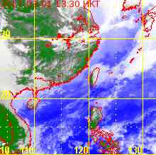
HKO Satellite 香港天文台衛星圖
HKO Track 香港天文台路徑圖
Probabilities
of TC Signals from HKO 香港天文台發出 / 取消熱帶氣旋警告信號的機率
10W is currently stuck between the subtropical ridge to the north and an equatorial ridge to its southeast. It is expected to remain quasi-stationary in the next 24 or 36 hours, generally moving N. Thereafter, the steering force should increase, allowing 10W to move N at a faster pace. It will turn NW later on as it reaches the southwestern edge of the subtropical ridge.
 Active Tropical Cyclone(s) 正活躍之熱帶氣旋