HALONG is travelling north in the Sea of Japan. At 8 am, HALONG was centred about 360 km (190 NM) W of Sapporo.
夏浪正於日本海北移。在上午 8 時, 夏浪集結在札幌以西約 360 公里 (190 海里)。
TC
Naming 氣旋命名
HALONG is the 56th name in the tropical cyclone name list. It was contributed by Vietnam, and is a city in that country. This name was used in 2002 and 2008.
HALONG is the 56th name in the tropical cyclone name list. It was contributed by Vietnam, and is a city in that country. This name was used in 2002 and 2008.
HALONG is expected to move NNE turning back to N along the flow of the westerlies, crossing the Sea of Japan tonight and tomorrow.
夏浪將沿西風帶流場向東北偏北轉北移動,於今晚及明日橫過日本海。
Intensity
Analysis 強度分析
Current T-number 現時的 T 號碼: N/A 不適用
HALONG's convections are still tight while crossing Japan. It is expected to weaken as land interaction increases and later due to lower sea temperatures, and should turn extratropical by t+36.
HALONG is approaching Shikoku. At 8 am, HALONG was centred about 210 km (120 NM) SE of Kagoshima.
夏浪正靠近四國。在上午 8 時, 夏浪集結在鹿兒島東南約 210 公里 (120 海里)。
TC
Naming 氣旋命名
HALONG is the 56th name in the tropical cyclone name list. It was contributed by Vietnam, and is a city in that country. This name was used in 2002 and 2008.
HALONG is expected to move N or NNE along the western periphery of the subtropical ridge, and should accelerate within the westerlies. Due to a change in the steering flow within the westerlies, HALONG may turn back to N later, making landfall in Russia.
HALONG is the 56th name in the tropical cyclone name list. It was contributed by Vietnam, and is a city in that country. This name was used in 2002 and 2008.
HALONG is expected to move N or NNE along the western periphery of the subtropical ridge, and should accelerate within the westerlies.
夏浪將沿副熱帶高壓脊西部向北或東北偏北移動,並於西風帶中加速。
Intensity
Analysis 強度分析
Current T-number 現時的 T 號碼: T4.0/4.5/W1.0/24 HRS
HALONG's eye becomes ragged. It is expected to maintain intensity until around t+36 when land interaction kicks in and weakens the system. Extratropical transition should occur between t+72 and t+96.
HALONG intensified slightly yesterday. At 8 am, HALONG was centred about 420 km (230 NM) ESE of Okinawa.
夏浪昨日稍為增強。在上午 8 時, 夏浪集結在沖繩島東南偏東約 420 公里 (230 海里)。
TC
Naming 氣旋命名
HALONG is the 56th name in the tropical cyclone name list. It was contributed by Vietnam, and is a city in that country. This name was used in 2002 and 2008.
HALONG should move N along the western periphery of the subtropical ridge, and is expected to turn NNE as it reaches southern Japan. Track speed will increase as HALONG enters the westerlies.
夏浪將沿副熱帶高壓脊西部向北移,並於到達日本南部時轉向東北偏北。隨後夏浪進入西風帶,其移速將加快。
Intensity
Analysis 強度分析
Current T-number 現時的 T 號碼: T5.0/5.0/S0.0/24 HRS
HALONG's eye improved yesterday afternoon, and the storm is expected to maintain category 2 intensity in the next 36 hours. Thereafter, the westerlies will start to interact with the system. Together with land interaction, HALONG will weaken at a faster rate. Extratropical transition is expected 4 days later.
HALONG is the 56th name in the tropical cyclone name list. It was contributed by Vietnam, and is a city in that country. This name was used in 2002 and 2008.
HALONG is expected to move N or NNE in the short run due to a slight dent in the subtropical ridge induced by an upper-level low. As the subtropical ridge resumes its natural N-S orientation at higher latitudes, HALONG may swing back to the west slightly (or at least move due north) before recurving into Japan.
HALONG is showing signs of re-intensification over the past 6 hours. It is expected to reach category 3 again due to improved divergence, but land interaction should cause the storm to weaken as it nears Japan. Extratropical transition is expected 5 days later.
HALONG is the 56th name in the tropical cyclone name list. It was contributed by Vietnam, and is a city in that country. This name was used in 2002 and 2008.
HALONG is expected to move N or NNE in the short run due to a slight dent in the subtropical ridge induced by an upper-level low. As the subtropical ridge resumes its natural N-S orientation at higher latitudes, HALONG may swing back to the west slightly before recurving into Japan.
HALONG's central dense overcast continues to shrink in size, but atmospheric conditions should be supportive of its current intensity as the storm goes north. There might be some slight intensification later on due to the improvement of divergence ahead of the mid-latitude trough. HALONG should weaken as it reaches Japan due to land interaction.
HALONG is the 56th name in the tropical cyclone name list. It was contributed by Vietnam, and is a city in that country. This name was used in 2002 and 2008.
HALONG has reached the western end of the subtropical ridge and is expected to turn north soon. Due to the shape of the ridge, a slight deflection to the east is possible, which may be followed by one to the west as the ridge extends slightly at higher latitudes.
HALONG's eye shrank in size and eyewall cloud top temperatures have risen. Strengthening of vertical wind shear and diminishing outflow will cause HALONG to weaken in the next few days.
HALONG is the 56th name in the tropical cyclone name list. It was contributed by Vietnam, and is a city in that country. This name was used in 2002 and 2008.
The subtropical ridge appears rectangular in shape; HALONG is expected to turn north abruptly when it reaches the western edge of the ridge. The ridge may extend westward slightly at higher latitudes which could result in a turn to the NNW, but there exists substantial uncertainty to this.
HALONG developed a thick central dense overcast and a clear eye is embedded within it. The storm is believed to have reached maximum intensity; a drop in divergence may see the storm weaken gradually from now on, although it should remain a significant typhoon throughout the forecast period.
HALONG started rapid intensification and is currently estimated to be a category 2 typhoon. At 8 am, HALONG was centred about 620 km (340 NM) NNW of Yap.
HALONG is the 56th name in the tropical cyclone name list. It was contributed by Vietnam, and is a city in that country. This name was used in 2002 and 2008.
HALONG is expected to move W in the next 24 hours before turning N as it reaches the western end of the subtropical ridge.
夏浪將於未來 24 小時西移,隨後它將移至副熱帶高壓脊西部邊沿,繼而轉向北移。
Intensity
Analysis 強度分析
Current T-number 現時的 T 號碼: T5.0/5.0/D1.5/24 HRS
Shear starts to ease and equatorward outflow has improved substantially in the past 24 hours. HALONG is undergoing rapid intensification and should reach category 4 tonight. At later taus, divergence channels are forecast to diminish, causing HALONG to weaken.
HALONG is the 56th name in the tropical cyclone name list. It was contributed by Vietnam, and is a city in that country. This name was used in 2002 and 2008.
HALONG dips south as it organizes itself. The storm is about to reach the southwestern edge of the subtropical ridge, and is expected to turn NW. Such motion should persist until t+120.
HALONG successfully wraps its convection to the northern semicircle, enclosing the circulation centre. However, the storm is still subject to strong vertical wind shear which will lower its rate of intensification.
夏浪成功將對流捲至北半圓並覆蓋其環流中心。可是風暴仍然受較強垂直風切變的影響,這會減慢其增強速度。
Effects on
Hong Kong 對香港的影響
No threat to Hong Kong is expected within the next 72 hours.
預料夏浪於未來的 72 小時將不會對香港構成影響。
Next Update
下次更新
2014/08/02 (Sat 六), afternoon 下午 (or earlier 或更早)
Other Images
其他圖像
JTWC Track 聯合颱風警報中心路徑圖
JMA Track 日本氣象廳路徑圖
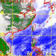
HKO Satellite 香港天文台衛星圖
HKO Track 香港天文台路徑圖
Probabilities
of TC Signals from HKO 香港天文台發出 / 取消熱帶氣旋警告信號的機率
HALONG is the 56th name in the tropical cyclone name list. It was contributed by Vietnam, and is a city in that country. This name was used in 2002 and 2008.
HALONG is expected to move WNW to NW along the southwestern periphery of the subtropical ridge. It will turn more poleward after t+48 as the ridge is forecast to retreat. Significant interaction between HALONG and NAKRI is not expected as the two systems should maintain considerable distance throughout the forecast period.
There is substantial shear along NAKRI's periphery which affects HALONG and displaces much of its convections to the south, rendering its low-level circulation centre exposed. In such condition, slower intensification is expected.
HALONG is moving WNW steadily. At 2 pm, HALONG was centred about 95 km (50 NM) NNW of Guam.
夏浪穩定向西北偏西移動。在下午 2 時, 夏浪集結在關島西北偏北約 95 公里 (50 海里)。
TC
Naming 氣旋命名
HALONG is the 56th name in the tropical cyclone name list. It was contributed by Vietnam, and is a city in that country. This name was used in 2002 and 2008.
HALONG is expected to move WNW to NW along the southwestern periphery of the subtropical ridge. It will turn more poleward later as the ridge is forecast to retreat. Significant interaction between HALONG and NAKRI is not expected as the two systems should maintain considerable distance throughout the forecast period.
There is substantial shear along NAKRI's periphery which affects HALONG and displaces much of its convections to the south. In such condition, slower intensification is expected.
娜基莉周邊垂直風切變較高,並影響夏浪致其對流向南切離。在此情況下,預料夏浪的增強速度會較慢。
Effects on
Hong Kong 對香港的影響
No threat to Hong Kong is expected within the next 72 hours.
預料夏浪於未來的 72 小時將不會對香港構成影響。
Next Update
下次更新
2014/07/31 (Thu 四), afternoon 下午 (or earlier 或更早)
Other Images
其他圖像
JTWC Track 聯合颱風警報中心路徑圖
JMA Track 日本氣象廳路徑圖
HKO Satellite 香港天文台衛星圖
HKO Track 香港天文台路徑圖
Probabilities
of TC Signals from HKO 香港天文台發出 / 取消熱帶氣旋警告信號的機率
Tropical depression 11W formed last night. It quickly intensified into a severe tropical storm today and was named HALONG. At 2 pm, HALONG was centred about 350 km (190 NM) ESE of Guam.
HALONG is the 56th name in the tropical cyclone name list. It was contributed by Vietnam, and is a city in that country. This name was used in 2002 and 2008.
HALONG is expected to move WNW to NW along the southwestern periphery of the subtropical ridge. It will turn more poleward later as the ridge is forecast to retreat. Another system (96W) is developing to the WNW of HALONG, but significant interaction is not expected as the two systems are still far apart and are both subject to considerable background steering flow.
HALONG developed quickly in the past 24 hours; convective bands are tightening near the centre. Intensification is expected throughout the forecast period.
夏浪於過去 24 小時快速發展,中心對流漸轉緊密,預料夏浪會於整個預測期內增強。
Effects on
Hong Kong 對香港的影響
No threat to Hong Kong is expected within the next 72 hours.
預料夏浪於未來的 72 小時將不會對香港構成影響。
Next Update
下次更新
2014/07/30 (Wed 三), afternoon 下午 (or earlier 或更早)
Other Images
其他圖像
JTWC Track 聯合颱風警報中心路徑圖
JMA Track 日本氣象廳路徑圖
HKO Satellite 香港天文台衛星圖
HKO Track 香港天文台路徑圖
Probabilities
of TC Signals from HKO 香港天文台發出 / 取消熱帶氣旋警告信號的機率
 Active Tropical Cyclone(s) 正活躍之熱帶氣旋