TC Watch / 熱帶氣旋 > Latest TC Info 最新熱帶氣旋資訊 [Refresh 更新]

Quick links 快速連結: Current Storm Info 實時氣旋資料 Past Storm Info 過去氣旋資料
HKO Storm Info 天文台之熱帶氣旋資訊 TC Archive 熱帶氣旋資料庫
Official TC Track Info 官方熱帶氣旋路徑資料 Selected TC Review 重要熱帶氣旋回顧
Tracks from Non-Governmental Agencies 民辦網站預測路徑圖 TC Finder 熱帶氣旋尋找工具
Active Tropical Cyclone(s) 正活躍之熱帶氣旋

Current TC Map 即時氣旋資訊Current TC information

Tropical Cyclone Report 熱帶氣旋報告 [Our partner site's TC update 按此看友站的氣旋動態報告]

1. 15W (KALMAEGI 海鷗)

Name of System 系統名稱

STS KALMAEGI 強烈熱帶風暴 海鷗


JTWC No. / Int'l No. JTWC 編號 / 國際編號 15W / 1415
Bulletin Number 發佈編號 #8 FINAL BULLETIN 最後發佈
Time of Report 報告時間

2014/09/17, 12:45 HKT (04:45 UTC)

Time of Observation 觀測時間 2014/09/17, 08:00 HKT (00:00 UTC)
Position 位置 22.3°N, 104.8°E
Maximum Gust 最高陣風 65 knots 節 (120 km/h 公里每小時)
1-min. Average Wind Speed 1分鐘平均風速 55 knots 節 (100 km/h 公里每小時)
10-min. Average Wind Speed 10分鐘平均風速 50 knots 節 (95 km/h 公里每小時)
Pressure 氣壓 985 hPa 百帕斯卡
Past 6-hr Movement 過去6小時移向和移速 WNW 西北偏西 (292°) at 19 knots 節 (35 km/h 公里每小時)
Area(s) affected 受影響地區 Northern Vietnam 越南北部

Forecast Track 預測路徑圖

Forecast Positions 預測位置資料

Tau
時間差
HK Time
香港時間
Lat.
緯度
Long.
經度
Movement
移動速度和方向
1-min Average Strength
一分鐘平均強度
Distance/Bearing from HK
與香港的距離和方位角
t+0 09/17 (Wed) 08:00 22.3°N 104.8°E WNW 西北偏西 (290°) 25 km/h 55 kt (102 km/h) STS 強烈熱帶風暴 W 西 963 km
t+12 09/17 (Wed) 20:00 23.2°N 102.0°E WNW 西北偏西 (286°) 20 km/h 35 kt (65 km/h) TS 熱帶風暴 W 西 1251 km
t+24 09/18 (Thu) 08:00 23.8°N 99.7°E N/A 20 kt (37 km/h) LPA 低壓區 W 西 1488 km
Overview 總覽

KALMAEGI made landfall at northern Vietnam last night and is now crossing the country. At 8 am, KALMAEGI was centred about 180 km (95 NM) NW of Hanoi. All tropical cyclone signals were cancelled at 2:10 am.

海鷗昨晚登陸越南北部,現時正橫過該國。在上午 8 時, 海鷗集結在河內西北約 180 公里 (95 海里)。

TC Naming 氣旋命名

KALMAEGI is the 59th name in the tropical cyclone name list. It was contributed by North Korea, meaning seagull. This name was used in 2002 and 2008.

海鷗為熱帶氣旋名稱列表中第 59 個名字,由北韓提供。此名曾於 2002 及 2008 年使用。

Movement Analysis 路徑分析

KALMAEGI will move WNW inland.

海鷗將向西北偏西移動,深入內陸。

Intensity Analysis 強度分析

Current T-number 現時的 T 號碼: N/A 不適用

Without the supply of moisture, KALMAEGI will weaken rapidly and is expected to dissipate by tomorrow.

由於缺乏濕潤空氣的供應,預料海鷗將快速減弱,並於明天消散

Effects on Hong Kong 對香港的影響

Showers will ease as the anticyclone over southern China strengthens.

隨著華南的反氣旋增強,驟雨將逐漸減少。

Next Update 下次更新

This is the final bulletin on KALMAEGI.

這是本站對海鷗的最後一次發佈。

Other Images 其他圖像
JTWC Track 聯合颱風警報中心路徑圖
JMA Track 日本氣象廳路徑圖
HKO Satellite 香港天文台衛星圖
HKO Track 香港天文台路徑圖
Probabilities of TC Signals from HKO 香港天文台發出 / 取消熱帶氣旋警告信號的機率

N/A 不適用


Past Bulletins (click on the bulletin no. for the contents) 過往報告 (請按發佈編號顯示內容)

+15W (KALMAEGI 海鷗) Bulletin 發佈 #7 (2014/09/16, 09:45 HKT)

Name of System 系統名稱

TY (CAT. 1) KALMAEGI 一級颱風 海鷗


JTWC No. / Int'l No. JTWC 編號 / 國際編號 15W / 1415
Bulletin Number 發佈編號 #7
Time of Report 報告時間

2014/09/16, 09:45 HKT (01:45 UTC)

Time of Observation 觀測時間 2014/09/16, 08:00 HKT (00:00 UTC)
Position 位置 19.8°N, 111.6°E
Maximum Gust 最高陣風 90 knots 節 (165 km/h 公里每小時)
1-min. Average Wind Speed 1分鐘平均風速 80 knots 節 (150 km/h 公里每小時)
10-min. Average Wind Speed 10分鐘平均風速 75 knots 節 (140 km/h 公里每小時)
Pressure 氣壓 960 hPa 百帕斯卡
Past 6-hr Movement 過去6小時移向和移速 WNW 西北偏西 (292°) at 13 knots 節 (25 km/h 公里每小時)
Area(s) affected 受影響地區 Hainan, W Guangdong 海南島及廣東西部

Forecast Track 預測路徑圖

Forecast Positions 預測位置資料

Tau
時間差
HK Time
香港時間
Lat.
緯度
Long.
經度
Movement
移動速度和方向
1-min Average Strength
一分鐘平均強度
Distance/Bearing from HK
與香港的距離和方位角
t+0 09/16 (Tue) 08:00 19.8°N 111.6°E WNW 西北偏西 (289°) 29 km/h 80 kt (148 km/h) TY (Cat. 1) 一級颱風 SW 西南 385 km
t+12 09/16 (Tue) 20:00 20.8°N 108.4°E WNW 西北偏西 (287°) 29 km/h 75 kt (139 km/h) TY (Cat. 1) 一級颱風 WSW 西南偏西 619 km
t+24 09/17 (Wed) 08:00 21.7°N 105.2°E WNW 西北偏西 (284°) 25 km/h 55 kt (102 km/h) STS 強烈熱帶風暴 W 西 926 km
t+36 09/17 (Wed) 20:00 22.3°N 102.4°E W 西 (281°) 24 km/h 35 kt (65 km/h) TS 熱帶風暴 W 西 1210 km
t+48 09/18 (Thu) 08:00 22.8°N 99.6°E N/A 20 kt (37 km/h) LPA 低壓區 W 西 1496 km
Overview 總覽

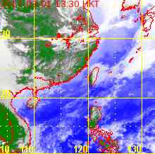
KALMAEGI is approaching northeastern Hainan. At 8 am, KALMAEGI was centred about 390 km (210 NM) SW of Hong Kong.

海鷗正靠近海南東北部。在上午 8 時, 海鷗集結在香港西南約 390 公里 (210 海里)。

TC Naming 氣旋命名

KALMAEGI is the 59th name in the tropical cyclone name list. It was contributed by North Korea, meaning seagull. This name was used in 2002 and 2008.

海鷗為熱帶氣旋名稱列表中第 59 個名字,由北韓提供。此名曾於 2002 及 2008 年使用。

Movement Analysis 路徑分析

KALMAEGI is expected to move WNW along the southwestern periphery of the subtropical ridge towards Qiongzhou Strait and northern Vietnam.

海鷗將繼續沿副熱帶高壓脊西南部向西北偏西移動,趨向瓊州海峽及越南北部。

Intensity Analysis 強度分析

Current T-number 現時的 T 號碼: T4.5/4.5/D0.5/24 HRS

KALMAEGI has intensified slightly over the past 6 hours. The storm is expected to weaken as it crosses the Gulf of Tonkin, and at a quicker pace upon landfall at northern Vietnam.

海鷗於過去 6 小時略為增強。預料風暴會於橫過北部灣時減弱,登陸越南北部後減弱速度會加快。

Effects on Hong Kong 對香港的影響

Winds in various places appear to weaken, but gales are still affecting southern parts of Hong Kong. As KALMAEGI retreats, winds will continue to subside although squally showers will continue to affect the territory.

本港多處風勢開始減弱,但烈風仍影響香港南部。隨著海鷗遠離,風力將繼續減弱,但本港仍會受狂風驟雨影響。

Next Update 下次更新

2014/09/17 (Wed 三), afternoon 下午 (or earlier 或更早)

Other Images 其他圖像
JTWC Track 聯合颱風警報中心路徑圖
JMA Track 日本氣象廳路徑圖
HKO Satellite 香港天文台衛星圖
HKO Track 香港天文台路徑圖
Probabilities of TC Signals from HKO 香港天文台發出 / 取消熱帶氣旋警告信號的機率

The Observatory will consider lower signals by midday.

天文台將於中午前考慮改發較低信號。

Signal 信號
t+12
t+24
t+36
t+48
t+60
t+72
Standby 戒備 #1 (Cnl. 取消) Medium 中等 Very High 極高 Very High 極高 Very High 極高 Very High 極高 Very High 極高
Strong Wind 強風 #3 (Cnl. 取消) Medium 中等 Very High 極高 Very High 極高 Very High 極高 Very High 極高 Very High 極高
Gale/Storm 烈或暴風 #8 (Cnl. 取消) Very High 極高 Very High 極高 Very High 極高 Very High 極高 Very High 極高 Very High 極高
G/S Incr. 烈或暴風增強 #9            
Hurricane 颶風 #10            

Notes 註:
1) For issuance, "Signal" column represents having issued that signal or above. 有關發出機率,首欄指已發出該信號或更高信號。
2) "Low" = Probability from 5 to 20 per cent; "Medium" = 20 to 50%; "High" = 50 to 80%; "V High" = 80% or above.
"低" = 5% - 20% 的機率; "中等" = 20 - 50%; "高" = 50 - 80%; "極高" = 80% 或以上。

+15W (KALMAEGI 海鷗) Bulletin 發佈 #6 (2014/09/16, 02:00 HKT)

Name of System 系統名稱

TY (CAT. 1) KALMAEGI 一級颱風 海鷗


JTWC No. / Int'l No. JTWC 編號 / 國際編號 15W / 1415
Bulletin Number 發佈編號 #6
Time of Report 報告時間

2014/09/16, 02:00 HKT (09/15 18:00 UTC)

Time of Observation 觀測時間 2014/09/16, 02:00 HKT (09/15 18:00 UTC)
Position 位置 19.3°N, 112.9°E
Maximum Gust 最高陣風 85 knots 節 (155 km/h 公里每小時)
1-min. Average Wind Speed 1分鐘平均風速 75 knots 節 (140 km/h 公里每小時)
10-min. Average Wind Speed 10分鐘平均風速 70 knots 節 (130 km/h 公里每小時)
Pressure 氣壓 965 hPa 百帕斯卡
Past 6-hr Movement 過去6小時移向和移速 WNW 西北偏西 (286°) at 15 knots 節 (27 km/h 公里每小時)
Area(s) affected 受影響地區 Northern South China Sea 南海北部

Forecast Track 預測路徑圖

Forecast Positions 預測位置資料

Tau
時間差
HK Time
香港時間
Lat.
緯度
Long.
經度
Movement
移動速度和方向
1-min Average Strength
一分鐘平均強度
Distance/Bearing from HK
與香港的距離和方位角
t+0 09/16 (Tue) 02:00 19.3°N 112.9°E WNW 西北偏西 (290°) 28 km/h 75 kt (139 km/h) TY (Cat. 1) 一級颱風 SSW 西南偏南 359 km
t+12 09/16 (Tue) 14:00 20.3°N 109.9°E WNW 西北偏西 (286°) 28 km/h 75 kt (139 km/h) TY (Cat. 1) 一級颱風 WSW 西南偏西 495 km
t+24 09/17 (Wed) 02:00 21.1°N 106.8°E WNW 西北偏西 (285°) 26 km/h 65 kt (120 km/h) TY (Cat. 1) 一級颱風 W 西 772 km
t+36 09/17 (Wed) 14:00 21.8°N 103.9°E W 西 (281°) 26 km/h 45 kt (83 km/h) TS 熱帶風暴 W 西 1059 km
t+48 09/18 (Thu) 02:00 22.3°N 100.9°E N/A 25 kt (46 km/h) TD 熱帶低氣壓 W 西 1364 km
Overview 總覽

KALMAEGI is moving rapidly across the South China Sea. At 2 am, KALMAEGI was centred about 360 km (190 NM) SSW of Hong Kong. The #8 Southeast Gale or Storm Signal was issued at 10:30 pm last night.

海鷗正快速橫過南海。在上午 2 時, 海鷗集結在香港西南偏南約 360 公里 (190 海里)。香港天文台於昨晚 10 時 30 分發出八號東南烈風或暴風信號。

TC Naming 氣旋命名

KALMAEGI is the 59th name in the tropical cyclone name list. It was contributed by North Korea, meaning seagull. This name was used in 2002 and 2008.

海鷗為熱帶氣旋名稱列表中第 59 個名字,由北韓提供。此名曾於 2002 及 2008 年使用。

Movement Analysis 路徑分析

KALMAEGI has resumed its WNW track. It is expected to move WNW along the southwestern periphery of the subtropical ridge towards Qiongzhou Strait and northern Vietnam.

海鷗已回復其西北偏西路徑,預料將繼續沿副熱帶高壓脊西南部向西北偏西移動,趨向瓊州海峽及越南北部。

Intensity Analysis 強度分析

Current T-number 現時的 T 號碼: T4.5/4.5/D0.5/24 HRS

KALMAEGI possesses a ragged eye, surrounded by tight cloudbands. As the system is moving rapidly, there will be insufficient time for the storm to consolidate and strengthen. A general weakening trend is expected as the storm enters the Gulf of Tonkin.

海鷗風眼形狀較不規則,但周邊雲帶緊密。由於系統移動迅速,它將缺乏時間重整和增強。預料風暴進入北部灣後將逐漸減弱。

Effects on Hong Kong 對香港的影響

Due to its speed, KALMAEGI's northern wind radii are very big; many places in Hong Kong are currently experiencing gale force winds, and storm force winds are observed occasionally offshore and on high ground. Wind direction is expected to veer from east to southeast soon. KALMAEGI is currently closest to Hong Kong; as the storm retreats, winds should weaken this morning. Squally showers will continue to affect the territory today.

由於海鷗速度快,其北半圓風圈甚廣,本港很多地方正吹烈風,離岸及高地間中更吹暴風。海鷗現時最為接近香港;隨著風暴遠離,風向將由偏東順轉至東南,而風勢將於今早減弱。本港今天將繼續受狂風驟雨影響。

Next Update 下次更新

2014/09/16 (Tue 二), afternoon 下午 (or earlier 或更早)

Other Images 其他圖像
JTWC Track 聯合颱風警報中心路徑圖
JMA Track 日本氣象廳路徑圖
HKO Satellite 香港天文台衛星圖
HKO Track 香港天文台路徑圖
Probabilities of TC Signals from HKO 香港天文台發出 / 取消熱帶氣旋警告信號的機率

Since widespread gales are still observed, it appears unlikely that the #8 Signal is cancelled in the morning rush hour. A more likely time would be later this morning or early afternoon.

由於本港正普遍吹烈風,八號信號於早上繁忙時間取消的機會較低,較可能的時間為早上較後時段或下午早段。

Signal 信號
t+12
t+24
t+36
t+48
t+60
t+72
Standby 戒備 #1 (Cnl. 取消) Low 低 High 高 Very High 極高 Very High 極高 Very High 極高 Very High 極高
Strong Wind 強風 #3 (Cnl. 取消) Medium 中等 Very High 極高 Very High 極高 Very High 極高 Very High 極高 Very High 極高
Gale/Storm 烈或暴風 #8 (Cnl. 取消) High 高 Very High 極高 Very High 極高 Very High 極高 Very High 極高 Very High 極高
G/S Incr. 烈或暴風增強 #9            
Hurricane 颶風 #10            

Notes 註:
1) For issuance, "Signal" column represents having issued that signal or above. 有關發出機率,首欄指已發出該信號或更高信號。
2) "Low" = Probability from 5 to 20 per cent; "Medium" = 20 to 50%; "High" = 50 to 80%; "V High" = 80% or above.
"低" = 5% - 20% 的機率; "中等" = 20 - 50%; "高" = 50 - 80%; "極高" = 80% 或以上。

+15W (KALMAEGI 海鷗) Bulletin 發佈 #5 (2014/09/15, 11:45 HKT)

Name of System 系統名稱

TY (CAT. 1) KALMAEGI 一級颱風 海鷗


JTWC No. / Int'l No. JTWC 編號 / 國際編號 15W / 1415
Bulletin Number 發佈編號 #5
Time of Report 報告時間

2014/09/15, 11:45 HKT (03:45 UTC)

Time of Observation 觀測時間 2014/09/15, 08:00 HKT (00:00 UTC)
Position 位置 18.0°N, 118.1°E
Maximum Gust 最高陣風 80 knots 節 (150 km/h 公里每小時)
1-min. Average Wind Speed 1分鐘平均風速 70 knots 節 (130 km/h 公里每小時)
10-min. Average Wind Speed 10分鐘平均風速 65 knots 節 (120 km/h 公里每小時)
Pressure 氣壓 970 hPa 百帕斯卡
Past 6-hr Movement 過去6小時移向和移速 W 西 (267°) at 16 knots 節 (30 km/h 公里每小時)
Area(s) affected 受影響地區 Northern South China Sea 南海北部

Forecast Track 預測路徑圖

Forecast Positions 預測位置資料

Tau
時間差
HK Time
香港時間
Lat.
緯度
Long.
經度
Movement
移動速度和方向
1-min Average Strength
一分鐘平均強度
Distance/Bearing from HK
與香港的距離和方位角
t+0 09/15 (Mon) 08:00 18.0°N 118.1°E WNW 西北偏西 (283°) 30 km/h 70 kt (130 km/h) TY (Cat. 1) 一級颱風 SE 東南 629 km
t+12 09/15 (Mon) 20:00 18.7°N 114.8°E WNW 西北偏西 (291°) 30 km/h 75 kt (139 km/h) TY (Cat. 1) 一級颱風 S 南 405 km
t+24 09/16 (Tue) 08:00 19.8°N 111.6°E WNW 西北偏西 (288°) 30 km/h 85 kt (157 km/h) TY (Cat. 2) 二級颱風 SW 西南 385 km
t+36 09/16 (Tue) 20:00 20.8°N 108.3°E WNW 西北偏西 (288°) 25 km/h 75 kt (139 km/h) TY (Cat. 1) 一級颱風 WSW 西南偏西 629 km
t+48 09/17 (Wed) 08:00 21.6°N 105.5°E WNW 西北偏西 (283°) 22 km/h 50 kt (93 km/h) STS 強烈熱帶風暴 W 西 897 km
t+72 09/18 (Thu) 08:00 22.6°N 100.5°E N/A 25 kt (46 km/h) TD 熱帶低氣壓 W 西 1404 km
Overview 總覽

KALMAEGI made landfall at Luzon last night and later entered the South China Sea. At 8 am, KALMAEGI was centred about 630 km (340 NM) SE of Hong Kong. The HK Observatory issued the #1 Standby Signal at 11:35 pm last night. [Update: The #3 Strong Wind Signal was issued at 12:40 pm]

海鷗昨晚登陸呂宋,隨後進入南海。在上午 8 時, 海鷗集結在香港東南約 630 公里 (340 海里)。香港天文台於昨晚 11 時 35 分發出一號戒備信號。[更新:三號強風信號於下午 12 時 40 分發出]

TC Naming 氣旋命名

KALMAEGI is the 59th name in the tropical cyclone name list. It was contributed by North Korea, meaning seagull. This name was used in 2002 and 2008.

海鷗為熱帶氣旋名稱列表中第 59 個名字,由北韓提供。此名曾於 2002 及 2008 年使用。

Movement Analysis 路徑分析

Due to land interaction, KALMAEGI has been moving more equatorward than projected since it left the Philippines. This effect is expected to diminish, and KALMAEGI should move WNW once again along the southwestern periphery of the subtropical ridge. Its forecast track speed has been increased to 30 km/h.

受地形影響,海鷗離開菲律賓後移向比預期偏西。預料此影響將逐漸減少,海鷗將沿副熱帶高壓脊西南部回復向西北偏西移動,而其移速則上調為每小時約 30 公里。

Intensity Analysis 強度分析

Current T-number 現時的 T 號碼: T4.0/4.0/S0.0/24 HRS

KALMAEGI's structure was disrupted by the Luzon terrain, but convections remain tight and appears to be redeveloping. The storm is expected to intensify as it crosses the warm South China Sea, but will start to weaken when it approches landmass.

海鷗的結構受呂宋地形干擾,但其對流仍然緊密,似乎開始重新發展。預料風暴將於橫過溫暖的南海時增強,並於靠近陸地時開始減弱

Effects on Hong Kong 對香港的影響

As KALMAEGI edges closer, the weather in Hong Kong will deteriorate tonight; winds will strengthen from the east/northeast and veer to southeast tomorrow. There will also be squally showers. KALMAEGI is a fast-moving system; members of the public should be on the alert.

隨著海鷗靠近,本港天氣將於今晚轉壞,東至東北風將增強並於明天順轉至東南風,且伴隨狂風驟雨。由於海鷗移動迅速,市民應提高警覺。

Next Update 下次更新

2014/09/16 (Tue 二), early hours 凌晨 (or earlier 或更早)

Other Images 其他圖像
JTWC Track 聯合颱風警報中心路徑圖
JMA Track 日本氣象廳路徑圖
HKO Satellite 香港天文台衛星圖
HKO Track 香港天文台路徑圖
Probabilities of TC Signals from HKO 香港天文台發出 / 取消熱帶氣旋警告信號的機率

The forecast track has been shifted south and the chance of issuing the #8 Gale or Storm Signal has decreased. However, as KALMAEGI moves rapidly across the South China Sea, its wind radii at its northern semicircle can still be large and gales cannot be ruled out.

由於預測路徑南調,發出八號烈風或暴風信號的機會減低,但海鷗於南海移速甚高,其北半圓風圈或會較大,現時仍未能完全排除出現烈風的可能性。

Signal 信號
t+12
t+24
t+36
t+48
t+60
t+72
Standby 戒備 #1 (Cnl. 取消)   Low 低 High 高 Very High 極高 Very High 極高 Very High 極高
Strong Wind 強風 #3 Very High 極高 High 高 Low 低      
Gale/Storm 烈或暴風 #8   Medium 中等        
G/S Incr. 烈或暴風增強 #9            
Hurricane 颶風 #10            

Notes 註:
1) For issuance, "Signal" column represents having issued that signal or above. 有關發出機率,首欄指已發出該信號或更高信號。
2) "Low" = Probability from 5 to 20 per cent; "Medium" = 20 to 50%; "High" = 50 to 80%; "V High" = 80% or above.
"低" = 5% - 20% 的機率; "中等" = 20 - 50%; "高" = 50 - 80%; "極高" = 80% 或以上。

+15W (KALMAEGI 海鷗) Bulletin 發佈 #4 (2014/09/14, 09:30 HKT)

Name of System 系統名稱

TY (CAT. 1) KALMAEGI 一級颱風 海鷗


JTWC No. / Int'l No. JTWC 編號 / 國際編號 15W / 1415
Bulletin Number 發佈編號 #4
Time of Report 報告時間

2014/09/14, 09:30 HKT (01:30 UTC)

Time of Observation 觀測時間 2014/09/14, 08:00 HKT (00:00 UTC)
Position 位置 16.5°N, 124.5°E
Maximum Gust 最高陣風 80 knots 節 (150 km/h 公里每小時)
1-min. Average Wind Speed 1分鐘平均風速 70 knots 節 (130 km/h 公里每小時)
10-min. Average Wind Speed 10分鐘平均風速 65 knots 節 (120 km/h 公里每小時)
Pressure 氣壓 970 hPa 百帕斯卡
Past 6-hr Movement 過去6小時移向和移速 WNW 西北偏西 (299°) at 14 knots 節 (27 km/h 公里每小時)
Area(s) affected 受影響地區 Philippine Sea 菲律賓以東海域

Forecast Track 預測路徑圖

Forecast Positions 預測位置資料

Tau
時間差
HK Time
香港時間
Lat.
緯度
Long.
經度
Movement
移動速度和方向
1-min Average Strength
一分鐘平均強度
Distance/Bearing from HK
與香港的距離和方位角
t+0 09/14 (Sun) 08:00 16.5°N 124.5°E WNW 西北偏西 (295°) 22 km/h 70 kt (130 km/h) TY (Cat. 1) 一級颱風 ESE 東南偏東 1259 km
t+12 09/14 (Sun) 20:00 17.5°N 122.2°E WNW 西北偏西 (292°) 23 km/h 85 kt (157 km/h) TY (Cat. 2) 二級颱風 ESE 東南偏東 994 km
t+24 09/15 (Mon) 08:00 18.4°N 119.8°E WNW 西北偏西 (287°) 26 km/h 75 kt (139 km/h) TY (Cat. 1) 一級颱風 SE 東南 729 km
t+36 09/15 (Mon) 20:00 19.2°N 116.9°E WNW 西北偏西 (287°) 26 km/h 80 kt (148 km/h) TY (Cat. 1) 一級颱風 SE 東南 446 km
t+48 09/16 (Tue) 08:00 20.0°N 114.0°E WNW 西北偏西 (286°) 23 km/h 90 kt (167 km/h) TY (Cat. 2) 二級颱風 S 南 256 km
t+72 09/17 (Wed) 08:00 21.3°N 108.8°E WNW 西北偏西 (285°) 22 km/h 80 kt (148 km/h) TY (Cat. 1) 一級颱風 W 西 565 km
t+96 09/18 (Thu) 08:00 22.4°N 103.9°E W 西 (280°) 18 km/h 50 kt (93 km/h) STS 強烈熱帶風暴 W 西 1055 km
t+120 09/19 (Fri) 08:00 23.0°N 99.8°E N/A 20 kt (37 km/h) LPA 低壓區 W 西 1475 km
Overview 總覽

KALMAEGI has intensified into a typhoon. At 8 am, KALMAEGI was centred about 430 km (230 NM) ENE of Manila.

海鷗已增強為颱風。在上午 8 時, 海鷗集結在馬尼拉東北偏東約 430 公里 (230 海里)。

TC Naming 氣旋命名

KALMAEGI is the 59th name in the tropical cyclone name list. It was contributed by North Korea, meaning seagull. This name was used in 2002 and 2008.

海鷗為熱帶氣旋名稱列表中第 59 個名字,由北韓提供。此名曾於 2002 及 2008 年使用。

Movement Analysis 路徑分析

KALMAEGI is expected to move WNW along the southwestern periphery of the subtropical ridge and make landfall at Luzon tonight. As it reaches higher latitudes and gets closer to the southern edge of the ridge, the track direction will turn west gradually. Steering from the ridge is strong and KALMAEGI is expected to move at around 25 km/h across northern South China Sea.

海鷗將沿副熱帶高壓脊西南部向西北偏西移動,並於今晚登陸呂宋。隨著海鷗北移並靠近副高南沿,其移向將漸轉偏西。由於副高周邊流場較強,預料海鷗將以每小時約 25 公里的高速橫過南海北部。

Intensity Analysis 強度分析

Current T-number 現時的 T 號碼: T4.0/4.0/D0.5/24 HRS

KALMAEGI is developing a central dense overcast. The storm is expected to intensify further before making landfall at Luzon, upon which development will halt due to land interaction. Seas in South China Sea are warm enough to fuel another round of intensification as the storm traverses the area.

海鷗正發展其中心密集雲區,預料將於登陸呂宋前繼續增強。風暴橫過呂宋時將受地形影響而略為減弱,但由於南海海溫較高,預料風暴能於該區再次發展。

Effects on Hong Kong 對香港的影響

Subsidence associated with KALMAEGI may result in very hot weather in southern China on Monday. As KALMAEGI edges closer, the weather in Hong Kong will deteriorate on Monday night and Tuesday; winds will strengthen from the east and veer to southeast during the day. There will also be squally showers. Strong force winds or stronger are expected on Tuesday; members of the public should be on the alert.

與海鷗相關的下沉氣流或會於周一為華南帶來酷熱天氣。隨著海鷗靠近,本港天氣將於周一晚上及周二轉壞,東風增強並於稍後順轉至東南風,並伴隨狂風驟雨。香港於周二將受強風或更高風速影響,市民應提高警覺。

Next Update 下次更新

2014/09/15 (Mon 一), afternoon 下午 (or earlier 或更早)

Other Images 其他圖像
JTWC Track 聯合颱風警報中心路徑圖
JMA Track 日本氣象廳路徑圖
HKO Satellite 香港天文台衛星圖
HKO Track 香港天文台路徑圖
Probabilities of TC Signals from HKO 香港天文台發出 / 取消熱帶氣旋警告信號的機率
Signal 信號
t+12
t+24
t+36
t+48
t+60
t+72
Standby 戒備 #1   Medium 中等 Very High 極高 Very High 極高 High 高 Low 低
Strong Wind 強風 #3     Medium 中等 Very High 極高 High 高 Low 低
Gale/Storm 烈或暴風 #8     Low 低 High 高 Medium 中等  
G/S Incr. 烈或暴風增強 #9       Low 低    
Hurricane 颶風 #10            

Notes 註:
1) For issuance, "Signal" column represents having issued that signal or above. 有關發出機率,首欄指已發出該信號或更高信號。
2) "Low" = Probability from 5 to 20 per cent; "Medium" = 20 to 50%; "High" = 50 to 80%; "V High" = 80% or above.
"低" = 5% - 20% 的機率; "中等" = 20 - 50%; "高" = 50 - 80%; "極高" = 80% 或以上。

+15W (KALMAEGI 海鷗) Bulletin 發佈 #3 (2014/09/13, 12:45 HKT)

Name of System 系統名稱

STS KALMAEGI 強烈熱帶風暴 海鷗


JTWC No. / Int'l No. JTWC 編號 / 國際編號 15W / 1415
Bulletin Number 發佈編號 #3
Time of Report 報告時間

2014/09/13, 12:45 HKT (04:45 UTC)

Time of Observation 觀測時間 2014/09/13, 08:00 HKT (00:00 UTC)
Position 位置 14.2°N, 128.8°E
Maximum Gust 最高陣風 65 knots 節 (120 km/h 公里每小時)
1-min. Average Wind Speed 1分鐘平均風速 55 knots 節 (100 km/h 公里每小時)
10-min. Average Wind Speed 10分鐘平均風速 50 knots 節 (95 km/h 公里每小時)
Pressure 氣壓 985 hPa 百帕斯卡
Past 6-hr Movement 過去6小時移向和移速 NW 西北 (311°) at 8 knots 節 (14 km/h 公里每小時)
Area(s) affected 受影響地區 Philippine Sea 菲律賓以東海域

Forecast Track 預測路徑圖

Forecast Positions 預測位置資料

Tau
時間差
HK Time
香港時間
Lat.
緯度
Long.
經度
Movement
移動速度和方向
1-min Average Strength
一分鐘平均強度
Distance/Bearing from HK
與香港的距離和方位角
t+0 09/13 (Sat) 08:00 14.2°N 128.8°E WNW 西北偏西 (296°) 19 km/h 55 kt (102 km/h) STS 強烈熱帶風暴 ESE 東南偏東 1785 km
t+12 09/13 (Sat) 20:00 15.1°N 126.9°E WNW 西北偏西 (296°) 19 km/h 65 kt (120 km/h) TY (Cat. 1) 一級颱風 ESE 東南偏東 1559 km
t+24 09/14 (Sun) 08:00 16.0°N 125.0°E WNW 西北偏西 (296°) 22 km/h 75 kt (139 km/h) TY (Cat. 1) 一級颱風 ESE 東南偏東 1334 km
t+36 09/14 (Sun) 20:00 17.0°N 122.8°E WNW 西北偏西 (288°) 25 km/h 85 kt (157 km/h) TY (Cat. 2) 二級颱風 ESE 東南偏東 1078 km
t+48 09/15 (Mon) 08:00 17.8°N 120.1°E WNW 西北偏西 (289°) 25 km/h 75 kt (139 km/h) TY (Cat. 1) 一級颱風 SE 東南 796 km
t+72 09/16 (Tue) 08:00 19.5°N 114.6°E WNW 西北偏西 (289°) 24 km/h 90 kt (167 km/h) TY (Cat. 2) 二級颱風 S 南 314 km
t+96 09/17 (Wed) 08:00 21.1°N 109.4°E WNW 西北偏西 (285°) 23 km/h 90 kt (167 km/h) TY (Cat. 2) 二級颱風 WSW 西南偏西 510 km
t+120 09/18 (Thu) 08:00 22.3°N 104.2°E N/A 50 kt (93 km/h) STS 強烈熱帶風暴 W 西 1025 km
Overview 總覽

KALMAEGI has slowed down and intensified into a severe tropical storm. At 8 am, KALMAEGI was centred about 840 km (460 NM) E of Manila.

海鷗明顯減速,並增強為強烈熱帶風暴。在上午 8 時, 海鷗集結在馬尼拉以東約 840 公里 (460 海里)。

TC Naming 氣旋命名

KALMAEGI is the 59th name in the tropical cyclone name list. It was contributed by North Korea, meaning seagull. This name was used in 2002 and 2008.

海鷗為熱帶氣旋名稱列表中第 59 個名字,由北韓提供。此名曾於 2002 及 2008 年使用。

Movement Analysis 路徑分析

The subtropical ridge has weakened in the past 24 hours, leading to a weaker steering flow. KALMAEGI is expected to turn WNW and approach Luzon. The ridge will strengthen again later and the storm should gradually turn equatorward as it traverses northern South China Sea.

副熱帶高壓脊於過去 24 小時減弱,令引導氣流轉弱,風暴移速減慢。預料海鷗將向西北偏西移動並靠近呂宋。副高將於稍後時間重新增強,這將令海鷗於橫過南海時移向漸轉偏西。

Intensity Analysis 強度分析

Current T-number 現時的 T 號碼: T3.5/3.5/D1.0/24 HRS

KALMAEGI benefits from decent divergence and warm sea temperatures, and is expected to intensify into a typhoon before landfall at Luzon. Some weakening is expected as KALMAEGI passes through the Philippines, but conditions in northern South China Sea are favourable for storm development.

受惠於良好輻散及高海溫,預料海鷗將繼續增強,於登陸呂宋前達到颱風強度。海鷗將於橫過菲律賓時減弱,但南海環境適合風暴再次發展。

Effects on Hong Kong 對香港的影響

Subsidence associated with KALMAEGI may result in very hot weather in southern China on Monday. As KALMAEGI edges closer, the weather in Hong Kong will deteriorate on Monday night and Tuesday; winds will strengthen from the east and veer to southeast during the day. There will also be squally showers.

與海鷗相關的下沉氣流或會於周一為華南帶來酷熱天氣。隨著海鷗靠近,本港天氣將於周一晚上及周二轉壞,東風增強並於稍後順轉至東南風,並伴隨狂風驟雨。

Next Update 下次更新

2014/09/14 (Sun 日), afternoon 下午 (or earlier 或更早)

Other Images 其他圖像
JTWC Track 聯合颱風警報中心路徑圖
JMA Track 日本氣象廳路徑圖
HKO Satellite 香港天文台衛星圖
HKO Track 香港天文台路徑圖
Probabilities of TC Signals from HKO 香港天文台發出 / 取消熱帶氣旋警告信號的機率
Signal 信號
t+12
t+24
t+36
t+48
t+60
t+72
Standby 戒備 #1       Medium 中等 Very High 極高 Very High 極高
Strong Wind 強風 #3         Low 低 High 高
Gale/Storm 烈或暴風 #8           Medium 中等
G/S Incr. 烈或暴風增強 #9           Low 低
Hurricane 颶風 #10            

Notes 註:
1) For issuance, "Signal" column represents having issued that signal or above. 有關發出機率,首欄指已發出該信號或更高信號。
2) "Low" = Probability from 5 to 20 per cent; "Medium" = 20 to 50%; "High" = 50 to 80%; "V High" = 80% or above.
"低" = 5% - 20% 的機率; "中等" = 20 - 50%; "高" = 50 - 80%; "極高" = 80% 或以上。

+15W (KALMAEGI 海鷗) Bulletin 發佈 #2 (2014/09/12, 15:45 HKT)

Name of System 系統名稱

TS KALMAEGI 熱帶風暴 海鷗


JTWC No. / Int'l No. JTWC 編號 / 國際編號 15W / 1415
Bulletin Number 發佈編號 #2
Time of Report 報告時間

2014/09/12, 15:45 HKT (07:45 UTC)

Time of Observation 觀測時間 2014/09/12, 14:00 HKT (06:00 UTC)
Position 位置 13.8°N, 130.8°E
Maximum Gust 最高陣風 45 knots 節 (85 km/h 公里每小時)
1-min. Average Wind Speed 1分鐘平均風速 35 knots 節 (65 km/h 公里每小時)
10-min. Average Wind Speed 10分鐘平均風速 30 knots 節 (55 km/h 公里每小時)
Pressure 氣壓 1002 hPa 百帕斯卡
Past 6-hr Movement 過去6小時移向和移速 W 西 (270°) at 14 knots 節 (25 km/h 公里每小時)
Area(s) affected 受影響地區 N/A 不適用

Forecast Track 預測路徑圖

Forecast Positions 預測位置資料

Tau
時間差
HK Time
香港時間
Lat.
緯度
Long.
經度
Movement
移動速度和方向
1-min Average Strength
一分鐘平均強度
Distance/Bearing from HK
與香港的距離和方位角
t+0 09/12 (Fri) 14:00 13.8°N 130.8°E W 西 (278°) 21 km/h 35 kt (65 km/h) TS 熱帶風暴 ESE 東南偏東 1992 km
t+12 09/13 (Sat) 02:00 14.1°N 128.5°E WNW 西北偏西 (285°) 18 km/h 45 kt (83 km/h) TS 熱帶風暴 ESE 東南偏東 1764 km
t+24 09/13 (Sat) 14:00 14.6°N 126.6°E WNW 西北偏西 (292°) 17 km/h 55 kt (102 km/h) STS 強烈熱帶風暴 ESE 東南偏東 1564 km
t+36 09/14 (Sun) 02:00 15.3°N 124.8°E WNW 西北偏西 (293°) 19 km/h 70 kt (130 km/h) TY (Cat. 1) 一級颱風 ESE 東南偏東 1361 km
t+48 09/14 (Sun) 14:00 16.1°N 122.8°E WNW 西北偏西 (294°) 20 km/h 80 kt (148 km/h) TY (Cat. 1) 一級颱風 SE 東南 1137 km
t+72 09/15 (Mon) 14:00 17.8°N 118.7°E WNW 西北偏西 (294°) 25 km/h 70 kt (130 km/h) TY (Cat. 1) 一級颱風 SE 東南 688 km
t+96 09/16 (Tue) 14:00 19.9°N 113.4°E WNW 西北偏西 (289°) 25 km/h 90 kt (167 km/h) TY (Cat. 2) 二級颱風 SSW 西南偏南 278 km
t+120 09/17 (Wed) 14:00 21.6°N 107.8°E N/A 85 kt (157 km/h) TY (Cat. 2) 二級颱風 W 西 661 km
Overview 總覽

15W has intensified into a tropical storm, and was named KALMAEGI. At 2 pm, KALMAEGI was centred about 1060 km (570 NM) E of Manila.

15W 已增強為熱帶風暴,被命名為海鷗。在下午 2 時, 海鷗集結在馬尼拉以東約 1060 公里 (570 海里)。

TC Naming 氣旋命名

KALMAEGI is the 59th name in the tropical cyclone name list. It was contributed by North Korea, meaning seagull. This name was used in 2002 and 2008.

海鷗為熱帶氣旋名稱列表中第 59 個名字,由北韓提供。此名曾於 2002 及 2008 年使用。

Movement Analysis 路徑分析

KALMAEGI appears to have travelled further north than expected due to a relocation of its centre. The subtropical ridge north of the system is expected to result in a generally westward movement in the next 24 hours. A weak passing trough will somewhat weaken the ridge slightly afterwards, and the storm should start to move WNW. The ridge is not expected to weaken enough to induce a recurvature.

由於重新定位,海鷗現時的緯度較原先預計為北。預料系統以北的副熱帶高壓脊將於未來 24 小時帶領風暴向偏西移動,隨後一微弱西風槽或令副高稍為減弱,從而令路徑轉為西北偏北。預測副高減弱程度將不足以令海鷗明顯轉向。

Intensity Analysis 強度分析

Current T-number 現時的 T 號碼: T2.5/2.5/D1.0/24 HRS

KALMAEGI has consolidated substantially in the past 12 hours, with convections wrapping effectively around the centre. In warm seas and with moderate shear, the storm should be able to intensify steadily before reaching Luzon. Some weakening is expected as KALMAEGI passes through the Philippines, but conditions in northern South China Sea are favourable for storm development.

海鷗於過去 12 小時明顯整合,可見對流有效地繞中心轉動。於溫暖海域及中等垂直風切變的環境下,預料風暴將能於登陸菲律賓前逐步增強。海鷗將於橫過菲律賓時減弱,但南海環境適合風暴再次發展。

Effects on Hong Kong 對香港的影響

Subsidence associated with KALMAEGI may result in very hot weather in southern China three days later.

與海鷗相關的下沉氣流或會於三日後為華南帶來酷熱天氣。

Next Update 下次更新

2014/09/13 (Sat 六), afternoon 下午 (or earlier 或更早)

Other Images 其他圖像
JTWC Track 聯合颱風警報中心路徑圖
JMA Track 日本氣象廳路徑圖
HKO Satellite 香港天文台衛星圖
HKO Track 香港天文台路徑圖
Probabilities of TC Signals from HKO 香港天文台發出 / 取消熱帶氣旋警告信號的機率
Signal 信號
t+12
t+24
t+36
t+48
t+60
t+72
Standby 戒備 #1           Medium 中等
Strong Wind 強風 #3            
Gale/Storm 烈或暴風 #8            
G/S Incr. 烈或暴風增強 #9            
Hurricane 颶風 #10            

Notes 註:
1) For issuance, "Signal" column represents having issued that signal or above. 有關發出機率,首欄指已發出該信號或更高信號。
2) "Low" = Probability from 5 to 20 per cent; "Medium" = 20 to 50%; "High" = 50 to 80%; "V High" = 80% or above.
"低" = 5% - 20% 的機率; "中等" = 20 - 50%; "高" = 50 - 80%; "極高" = 80% 或以上。

+15W Bulletin 發佈 #1 (2014/09/11, 12:45 HKT)

Name of System 系統名稱

TD 15W 熱帶低氣壓 15W


JTWC No. / Int'l No. JTWC 編號 / 國際編號 15W / ----
Bulletin Number 發佈編號 #1
Time of Report 報告時間

2014/09/11, 12:45 HKT (04:45 UTC)

Time of Observation 觀測時間 2014/09/11, 08:00 HKT (00:00 UTC)
Position 位置 10.3°N, 139.5°E
Maximum Gust 最高陣風 35 knots 節 (65 km/h 公里每小時)
1-min. Average Wind Speed 1分鐘平均風速 25 knots 節 (45 km/h 公里每小時)
10-min. Average Wind Speed 10分鐘平均風速 20 knots 節 (35 km/h 公里每小時)
Pressure 氣壓 1008 hPa 百帕斯卡
Past 6-hr Movement 過去6小時移向和移速 WNW 西北偏西 (284°) at 16 knots 節 (30 km/h 公里每小時)
Area(s) affected 受影響地區 Seas near Yap 雅蒲島一帶海域

Forecast Track 預測路徑圖

Forecast Positions 預測位置資料

Tau
時間差
HK Time
香港時間
Lat.
緯度
Long.
經度
Movement
移動速度和方向
1-min Average Strength
一分鐘平均強度
t+0 09/11 (Thu) 08:00 10.3°N 139.5°E WNW 西北偏西 (294°) 28 km/h 25 kt (46 km/h) TD 熱帶低氣壓
t+12 09/11 (Thu) 20:00 11.5°N 136.7°E WNW 西北偏西 (294°) 28 km/h 30 kt (56 km/h) TD 熱帶低氣壓
t+24 09/12 (Fri) 08:00 12.7°N 133.9°E WNW 西北偏西 (290°) 25 km/h 35 kt (65 km/h) TS 熱帶風暴
t+36 09/12 (Fri) 20:00 13.6°N 131.3°E WNW 西北偏西 (287°) 20 km/h 45 kt (83 km/h) TS 熱帶風暴
t+48 09/13 (Sat) 08:00 14.2°N 129.2°E WNW 西北偏西 (290°) 18 km/h 55 kt (102 km/h) STS 強烈熱帶風暴
t+72 09/14 (Sun) 08:00 15.5°N 125.5°E N/A 75 kt (139 km/h) TY (Cat. 1) 一級颱風
Overview 總覽

An area of low pressure near Yap has intensified into tropical depression 15W. At 8 am, 15W was centred about 170 km (95 NM) ENE of Yap.

於雅蒲島附近的一個低壓區已增強為熱帶低氣壓 15W。在上午 8 時, 15W 集結在雅蒲島東北偏東約 170 公里 (95 海里)。

TC Naming 氣旋命名

N/A 不適用

Movement Analysis 路徑分析

15W is situated in the southern periphery of a subtropical ridge, which has a slight weakness ahead of the storm. It is expected to move WNW in the next 72 hours in the general direction of seas east of Luzon.

15W 處於副熱帶高壓脊以南,該副高於風暴路徑前方有一細小弱點,預料風暴會於未來 72 小時向西北偏西移動,靠近呂宋以東海域。

Intensity Analysis 強度分析

Current T-number 現時的 T 號碼: T1.5/1.5/INT OBS

15W will need some time to consolidate. Thereafter, warm seas and relatively low vertical wind shear will allow the storm to intensify at a quicker pace.

15W 需時整合,隨後溫暖海水及較低垂直風切變將有利風暴以較快速度增強。

Effects on Hong Kong 對香港的影響

No threat to Hong Kong is expected within the next 72 hours.

預料 15W 於未來的 72 小時將不會對香港構成影響。

Next Update 下次更新

2014/09/12 (Fri 五), afternoon 下午 (or earlier 或更早)

Other Images 其他圖像
JTWC Track 聯合颱風警報中心路徑圖
JMA Track 日本氣象廳路徑圖
HKO Satellite 香港天文台衛星圖
HKO Track 香港天文台路徑圖
Probabilities of TC Signals from HKO 香港天文台發出 / 取消熱帶氣旋警告信號的機率
N/A 不適用

Track Data from HKWW 本站之路徑資料

YYMMDDZZ Lat Long Wind
14091018 099N1411E 025
14091100 103N1395E 025
14091106 127N1384E 025
14091112 138N1369E 025
14091118 138N1340E 030
14091200 138N1322E 030
14091206 138N1308E 035
14091212 137N1302E 040
14091218 137N1294E 045
14091300 142N1288E 055
14091306 148N1276E 060
14091312 151N1268E 065
14091318 158N1258E 065
14091400 165N1245E 070
14091406 170N1235E 070
14091412 178N1218E 070
14091418 181N1198E 065
14091500 180N1181E 070
14091506 184N1162E 075
14091512 189N1144E 075
14091518 193N1129E 075
14091600 198N1116E 080
14091606 204N1099E 080
14091612 211N1084E 075
14091618 216N1067E 065
14091700 223N1048E 055