
TC Watch / 熱帶氣旋 > Selected TC Review / 重要熱帶氣旋回顧 > 201407E (GENEVIEVE) [Refresh 更新]
 201407E (GENEVIEVE) - Profile 檔案 201407E (GENEVIEVE) - Profile 檔案 |
(Issued on December 7, 2014)
(於 2014 年 12 月 7 日發出)
Brief profile of GENEVIEVE | GENEVIEVE小檔案:
| JTWC number 聯合颱風警報中心 (JTWC) 號碼 | 07E |
| International number 國際編號 | 1413 |
| Period of existence 生存時期 (JTWC) | 2014/07/21 02 HKT - 2014/08/12 14 HKT (In NW Pacific 於西北太平洋: 2014/08/07 14 HKT - 2014/08/12 14 HKT) |
| Lifetime 壽命 (JTWC) | 22.50 days 日 (In NW Pacific 於西北太平洋: 5.00 days 日) |
| Maximum 1-minute wind (JTWC) JTWC 一分鐘平均最高中心風速 | 140 knots 節 (Category 5 Super Typhoon 五級超級颱風) |
| Minimum pressure (JTWC) JTWC 最低氣壓 | 918 hPa 百帕 |
| Highest TC signal by HKO (if applicable) 香港天文台發出最高熱帶氣旋警告信號 |
N/A 不適用 |
| Closest point of approach by HKO (if applicable) 香港天文台所示之最接近距離 (如適用) |
N/A 不適用 |
| Time of closest approach by HKO (if applicable) 香港天文台所示之最接近時間 (如適用) |
N/A 不適用 |
| Lowest pressure recorded at HKO (if applicable) 香港天文台錄得的最低氣壓 (如適用) |
N/A 不適用 |
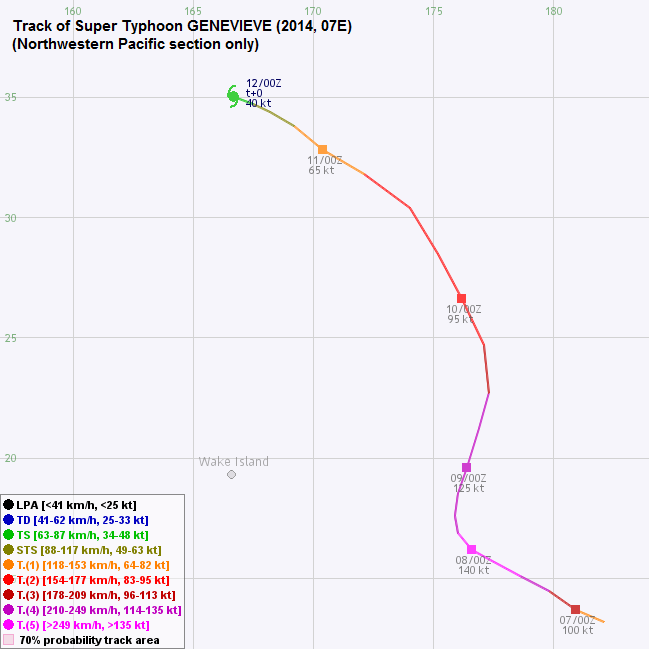
TC track (within NW Pacific) from HKWW 本站的熱帶氣旋路徑圖 (西北太平洋範圍):
| Past HKWW Bulletins on GENEVIEVE 本站有關GENEVIEVE的發佈 |
Please click here for bulletins on GENEVIEVE. 請按這裡。
| Storm Summary 氣旋摘要 |
Unless otherwise stated, all times below are in Hong Kong Standard Time (UTC+8)
除非特別註明,下文時間均為香港標準時間 (協調世界時加 8 小時)
Typhoon GENEVIEVE is the first tropical cyclone to cross the eastern, central and western Pacific basins since 2003.
GENEVIEVE started off as a blob of convections off the American coast in middle July. It drifted to the west without gathering much strength, before it was finally upgraded into a tropical storm on July 25. However, vertical wind shear was strong and the storm weakened back into a tropical depression the next day. GENEVIEVE entered central Pacific (west of 140°W) on July 27, still moving westward. In the next few days it degenerated further, but did not dissipate completely.
As environmental conditions improved on August 2, GENEVIEVE picked up strength again. It struggled at the beginning but eventually managed to develop convections on August 5. An eye developed and GENEVIEVE was upgraded into a hurricane on August 6. The storm turned WNW as the western edge of the subtropical ridge started to weaken. GENEVIEVE entered western Pacific shortly before 2 pm August 7, while it was undergoing rapid intensification. The central dense overcast became round and intense with cloud top temperatures dipping to below -70 degrees.
GENEVIEVE reached category 5 intensity at 8 pm August 7. As the ridge weakened further, GENEVIEVE decelerated and turned NNE on August 8. Lower sea temperatures led to GENEVIEVE's weakening from that point. It gradually weakened but still remained as a typhoon in the next two days. Although the subtropical ridge had weakened, it was still intact at higher latitudes. Under its influence GENEVIEVE accelerated and turned west gradually.
As the ridge dominated that area, divergence was severely restricted. Together with cool sea temperatures beyond 30°N, GENEVIEVE weakened into a tropical storm on August 11. Initially there were forecasts calling for an abrupt eastward turn due to another mid-latitude trough approaching the area, but GENEVIEVE weakened into an area of low pressure on August 12 before the turn could materialize.
GENEVIEVE 是自 2003 年來首個跨越東、中和西太平洋的熱帶氣旋。
一堆雲團於 7 月中旬在美洲對開海域形成,它一直西移但無甚發展,直至 25 日終被升格為熱帶風暴 GENEVIEVE,但由於該區垂直風切變較高,GENEVIEVE 於翌日減弱為熱帶低氣壓。GENEVIEVE 於 27 日進入中太平洋 (西經 140 度以西),繼續向西推進。它於隨後數天繼續減弱,但未完全消散。
隨著大氣環境於 8 月 2 日改善,GENEVIEVE 再度增強。初時 GENEVIEVE 發展略有阻滯,但最終其對流於 5 日增加,而其風眼於 6 日出現,風暴被升格為颶風。由於副熱帶高壓脊西緣開始減弱,GENEVIEVE 開始向西北偏西移動。GENEVIEVE 於 7 日下午 2 時前進入西太平洋,並迅速增強,其中心密集雲區渾圓、對流活動猛烈,雲頂溫度下降至 -70 度。
GENEVIEVE 於 7 日下午 8 時增強為五級超級颱風。副高於 8 日進一步減弱,GENEVIEVE 因而減速並向東北偏北推進。該區海溫較冷,GENEVIEVE 開始減弱,但仍於其後兩日維持颱風強度。雖然副高有所減弱,其於高緯度的勢力仍在,GENEVIEVE 於到達該區時開始加速並轉回偏西路徑。
由於副高盤據該區,風暴的輻散被嚴重限制,加上受北緯 30 度以北的偏低海溫影響,GENEVIEVE 於 11 日減弱為熱帶風暴。初時部分預測預計另一道西風槽會再度削弱副高並令 GENEVIEVE 突轉東移,但在此發生之前, GENEVIEVE 於 12 日已減弱成低壓區。
| Figures 圖片 |

Figure 1 - JTWC's track forecast just before GENEVIEVE entered west Pacific.
圖 1 - GENEVIEVE 進入西太平洋前,聯合颱風警報中心的路徑預測


Figures 2a and 2b - Visible satellite imageries of GENEVIEVE just before entering western Pacific (left) and on the international date line (right)
圖 2a 及 2b - GENEVIEVE 即將進入西太平洋 (左) 及在國際換日線上 (右) 時之可見光衛星雲圖
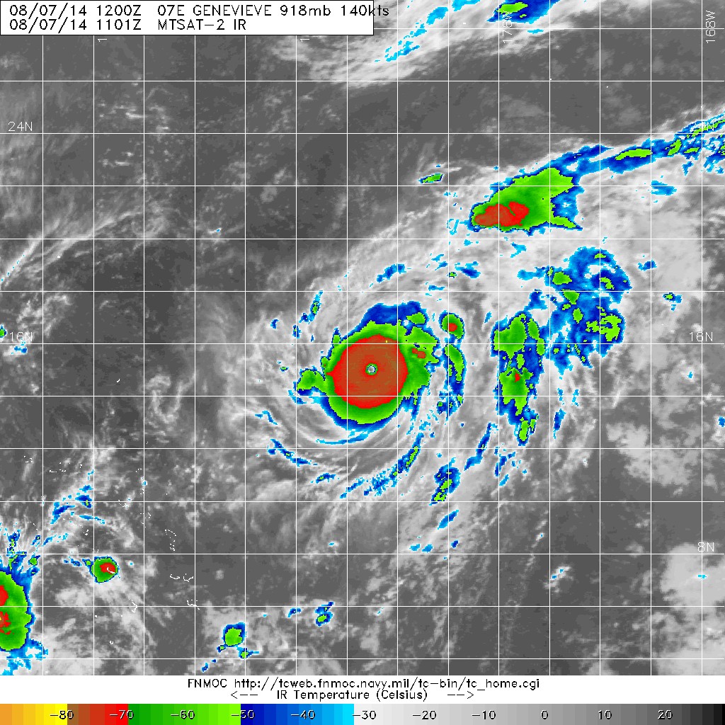
Figure 3 - GENEVIEVE at peak intensity
圖 3 - GENEVIEVE 到達巔峰強度
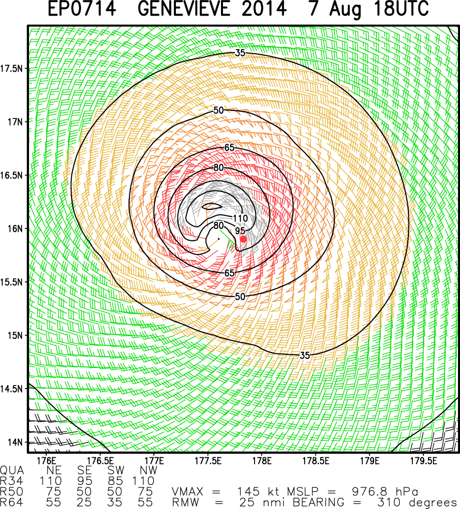
Figure 4 - GENEVIEVE's estimated wind field at 2 am August 8
圖 4 - 8 月 8 日上午 2 時 GENEVIEVE 之估計風場圖

Figure 5 - Forecast tracks from different agencies on August 8
圖 5 - 8 月 8 日各氣象台之預測路徑圖
| Other Data 其他數據 |
Table 1: Track data from HKWW:
表一 : 香港天氣觀測站之路徑資料
| YYMMDDZZ Lat Long Wind 14080618 132N1779W 075 14080700 137N1791W 100 14080706 145N1798E 130 14080712 151N1786E 140 14080718 157N1775E 140 14080800 162N1766E 140 14080806 169N1760E 135 14080812 176N1759E 130 14080818 185N1760E 125 14080900 196N1764E 125 14080906 212N1769E 115 14080912 227N1773E 105 14080918 247N1771E 095 14081000 266N1762E 095 14081006 285N1752E 095 14081012 304N1740E 090 14081018 318N1721E 075 14081100 328N1704E 065 14081106 338N1692E 060 14081112 344N1682E 050 14081118 347N1675E 045 14081200 350N1667E 040 |
Last Accessed 最近訪問日期: Sat Apr 20 2024 05:32:56 HKT
Last Modified 最近修訂日期: Mon Jul 24 2023
