
TC Watch / 熱帶氣旋 > Selected TC Review / 重要熱帶氣旋回顧 > 201409W (RAMMASUN 威馬遜) [Refresh 更新]
 201409W (RAMMASUN 威馬遜) - Profile 檔案 201409W (RAMMASUN 威馬遜) - Profile 檔案 |
(Issued on August 11, 2014)
(於 2014 年 8 月 11 日發出)
Brief profile of RAMMASUN 威馬遜小檔案:
| JTWC number 聯合颱風警報中心 (JTWC) 號碼 | 09W |
| International number 國際編號 | 1409 |
| Period of existence 生存時期 (JTWC) | 2014/07/10 20 HKT - 2014/07/19 20 HKT |
| Lifetime 壽命 (JTWC) | 9.00 days 日 |
| Maximum 1-minute wind (JTWC) JTWC 一分鐘平均最高中心風速 | 135 knots 節 (Category 4 Super Typhoon 四級超級颱風) |
| Minimum pressure (JTWC) JTWC 最低氣壓 | 922 hPa 百帕 |
| Highest TC signal by HKO (if applicable) 香港天文台發出最高熱帶氣旋警告信號 |
3 (Strong Wind Signal 強風信號) |
| Closest point of approach by HKO (if applicable) 香港天文台所示之最接近距離 (如適用) |
SW 390 km (real-time warning 實時報告 and 及 TC report 熱帶氣旋報告) |
| Time of closest approach by HKO (if applicable) 香港天文台所示之最接近時間 (如適用) |
2014/07/18 12 HKT (real-time warning 實時報告 and 及 TC report 熱帶氣旋報告) |
| Lowest pressure recorded at HKO (if applicable) 香港天文台錄得的最低氣壓 (如適用) |
1001.6 hPa 百帕 (2014/07/18 04:01 HKT) |
TC signals for Hong Kong & Track 香港曾經生效的熱帶氣旋警告和路徑圖:
Table 表:
| Signal 信號 |
Date and time 日期和時間 |
Distance from HK 與香港的距離 |
Predicted movement 預測移動方向和速度 |
Max. 10-min winds 中心最高十分鐘平均風速 |
 |
2014/07/16 (WED) 23:40 HKT | SSE 790 km | WNW at 25 km/h | 140 km/h (75 knots, CAT. 1 / T) |
 |
2014/07/17 (THU) 16:15 HKT | S 600 km | NW at 22 km/h | 145 km/h (80 knots, CAT. 1 / T) |
|
2014/07/18 (FRI) 19:40 HKT | WSW 460 km | NW/WNW at 22 km/h | 195 km/h (105 knots, CAT. 3 / SuT) |
 |
2014/07/19 (SAT) 19:40 HKT | WSW 540 km | NW/WNW at 22 km/h | 175 km/h (95 knots, CAT. 2 / ST) |
Figure 圖:
(Track courtesy of Lorenzo. Data from HKO. 鳴謝 Lorenzo 提供路徑圖,資料取自天文台)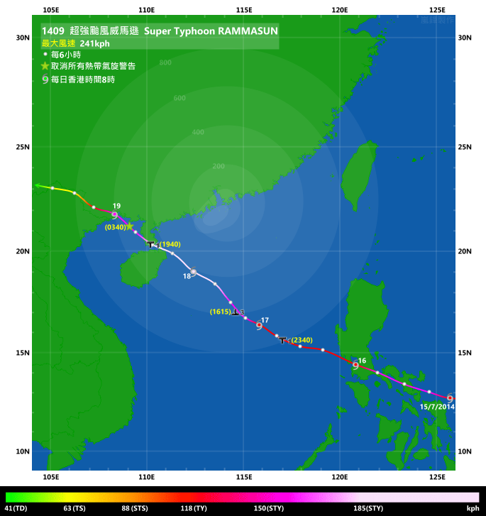
Percentile rank among storms with #3 Signal (at compilation of this review)*: *This measures the relative wind strength in Hong Kong caused by this storm compared with others that share the same signal. 指標顯示此風暴相對於其他發出同樣信號的風暴為香港帶來之風力強度 For more information, please refer to Wind Speed Data for TCs that Have Affected Hong Kong. 更多資訊載於 影響香港氣旋之風速數據 頁 |
Overall: 總計: |
|
Moderate 中等 |
|||
| Component Ranks 分部等級 | ||||||
| Reference stations: 參考站: |
|
Moderate 中等 |
||||
| Victoria Harbour: 維多利亞港: |
|
Moderately strong 中等偏強 |
||||
| Urban: 市區: |
|
Moderately strong 中等偏強 |
||||
| Offshore & high ground 離岸和高地: |
|
Moderate 中等 |
||||
Cyclones that attained similar rating (with signal #3): DURIAN (2001), RUSS (1994), AMY (1991), DOT (1989), PAT (1988) 相近級別之熱帶氣旋 (三號信號):榴槤 (2001), 羅士 (1994), 愛媚 (1991), 黛蒂 (1989), 帕特 (1988) |
||||||
IR imagery animation 紅外線雲圖動畫:
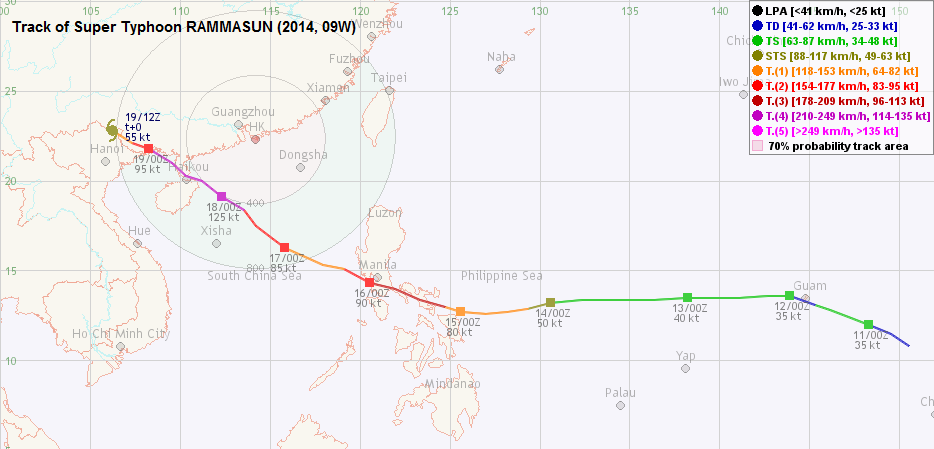
TC track from HKWW 本站的熱帶氣旋路徑圖:
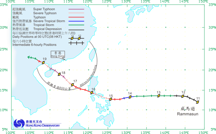
TC track from HKO 天文台的熱帶氣旋路徑圖:
| Past HKWW Bulletins on RAMMASUN 本站有關威馬遜的發佈 |
Please click here for bulletins on RAMMASUN. 請按這裡。
| Storm Formation and Development 氣旋形成和發展 |
Unless otherwise stated, all times below are in Hong Kong Standard Time (UTC+8)
除非特別註明,下文時間均為香港標準時間 (協調世界時加 8 小時)
RAMMASUN developed as a tropical wave near Chuuk in early July. The JTWC issued a tropical cyclone formation alert for the system at 2 pm July 10, and the first bulletin for this ninth tropical depression of the year was issued just 6 hours later. 09W was initially moving WNW, and is expected to turn west as a deep-layered subtropical ridge was anchored to its north.
09W intensified slightly on July 11 and crossed Guam during that night as a tropical storm. However, the JTWC subsequently downgraded 09W back into a tropical depression, as the its convections were sheared to the west with a weakly defined low-level circulation centre. The storm re-intensified the next day and turned west; the JMA upgraded 09W into a tropical storm at 2 pm July 12, naming it RAMMASUN which is the god of thunder in Thai.
Due to sub-optimal upper level environment, RAMMASUN failed to intensify on July 13. It moved westwards rapidly during the day, and this prompted agencies to shift their forecast tracks westwards. RAMMASUN was forecast to track west towards the Philippines, and then turn WNW as the ridge weakens and reorientates. The system started to dip south and intensify again on July 14. The HKO upgraded RAMMASUN into a severe tropical storm at 10 am, and further into a typhoon 12 hours later.
威馬遜的雛型為 7 月初在楚克島一帶海域發展的東風波。聯合颱風警報中心於 10 日下午 2 時對該系統發出熱帶氣旋形成警報,並於 6 小時後將其升格為熱帶低氣壓 09W。09W 初時向西北偏西移動,而由於一深層副熱帶高壓脊於 09W 北面,預料它將轉為西移。
09W 於 11 日稍為增強,當晚以熱帶風暴強度橫過關島,但其後聯合颱風警報中心因風暴對流向西切離及低層環流中心未算完整而將 09W 降回熱帶低氣壓強度。風暴最終於翌日再次增強,並以偏西方向移動。日本氣象廳於 12 日下午 2 時升格 09W 為熱帶風暴,並將其命名為威馬遜。該名稱由泰國提供,意思為雷神。
由於高層環境欠佳,威馬遜於 13 日未能增強。由於它當天快速西移,各機構將其預測路徑西調,預測威馬遜將一直西移至登陸菲律賓,隨後因副高減弱及型態轉變而導致威馬遜向西北偏西移動。威馬遜於 14 日稍為南移,並再次增強,香港天文台於當早 10 時將其升格為強烈熱帶風暴,並於 12 小時後升格為颱風。

Figure 1 - 09W moving towards Guam
圖 1 - 09W 靠近關島

Figure 2 - Steering flow map at 8 am July 13
圖 2 - 7 月 13 日上午 8 時之駛流圖


Figures 3a and 3b - Official meteorological agencies' forecast tracks on July 13 and July 16
圖 3a 及 3b - 官方氣象機構於 7 月 13 及 16 日的預測路徑圖
| Crossing the Philippines and Entering South China Sea 橫過菲律賓並進入南海 |
RAMMASUN developed a banding eye that night, which became much clearer during July 15 as outflow improved. The HKO upgraded RAMMASUN into a severe typhoon at 4 pm, 1 hour before the storm made landfall near Rapu-Rapu; meanwhile the JTWC adjusted RAMMASUN's intensity upwards into a category 3 typhoon. RAMMASUN moved WNW across the Philippines, passing through relatively flat landmass and some small bays. As a result, RAMMASUN did not lose much intensity during its passage.
The storm turned slightly equatorward after midnight July 16. It passed about 40 km SW of Manila as a category 2 typhoon that morning, and emerged into the South China Sea at around 8 am. The effects of crossing the Philippines gradually became apparent; a blob of convections developed to the west of its core, and RAMMASUN's northern semicircle suffered a significant disruption. It was downgraded into a typhoon (category 1 typhoon for the JTWC) soon after leaving the Philippines.
The subtropical ridge has retreated slightly, placing RAMMASUN in its southwestern periphery. At this stage various agencies had very close forecasts, predicting a landfall at the northeastern edge of Hainan which eventually became true. However, none of them predicted the rapid intensification that would take place later on.
RAMMASUN took some time to re-organize its convections on July 16, and deflected to the west again. It entered Hong Kong's 800 km circle that night; the HKO promptly issued the #1 Standby Signal at 11:40 pm, when RAMMASUN was 790 km SSE of the territory. RAMMASUN's westward deflection was compensated by a more poleward turn on July 17. The storm took a more northwesterly track, and intensified again after its northern semicircle was rebuilt.
RAMMASUN was still around 700 km away from Hong Kong in the morning of July 17. However, due to its large wind radii (the HKO estimated a gale radius of 180 NM/330 km and 2-metre wave radius of 330 NM/610 km that morning), the Observatory stated that the #3 Signal would be considered that afternoon. Locally, RAMMASUN's outermost rainbands started to affect southern parts of Hong Kong later that morning. Winds also strengthened from the east; gusts of 70 km/h were recorded at Cheung Chau Beach and Green Island near 1 pm.
The Observatory issued the #3 Strong Wind Signal at 4:15 pm as winds continued to strengthen and RAMMASUN was showing signs of intensification. At that time, gales were blowing at some offshore stations including Waglan Island and Green Island, and strong winds were observed at some more, for example Cheung Chau, Chek Lap Kok, Sai Kung and Tai Mei Tuk. The Observatory indicated that winds in southwestern Hong Kong may reach gale force later that night as RAMMASUN passed to the southwest.
RAMMASUN continued to move northwest during the night. A clear eye emerged within its central dense overcast and became visible in infrared imagery. The HKO upgraded it into a severe typhoon at 7 pm, while the JTWC updated RAMMASUN's intensity upwards to category 3 in their 8 pm bulletin. In Hong Kong, winds were relatively stable, although quite strong, during the night. There were also squally showers and some thunderstorms. Many stations saw an increase in wind speed near 4-5 am July 18 in the wake of another arriving rainband. Winds at Cheung Chau reached gale force for the first time, and at 40 km/h winds at King's Park almost reached strong force.
Still crossing the relatively warm South China Sea, RAMMASUN further consolidated during the night. The JTWC upgraded RAMMASUN into a category 4 typhoon at 2 am July 18. As RAMMASUN was maintaining considerable distance (more than 400 km) from Hong Kong, its gale radius was not wide enough to reach the territory, justifying the Observatory's decision not to issue higher signals.
威馬遜於當晚建立雲捲風眼,而隨著輻散於 15 日改善,風眼漸變清晰。天文台於下午 4 時將威馬遜升格為強颱風,而風暴於一小時後登陸菲律賓拉普拉普附近,至於聯合颱風警報中心則上調威馬遜的強度至三級颱風。威馬遜以西北偏西移徑橫過菲律賓,所經之處多為平地及海灣,於是它在橫過該國時強度減弱較少。
威馬遜於 16 日午夜過後以偏西方向移動,早上以二級颱風強度於馬尼拉西南約 40 公里處掠過,並於上午 8 時左右進入南海。入海後陸地對威馬遜的影響漸變明顯,風暴於西面發展出一堆雲團,而風暴北面的破壞較為明顯。它於離開菲律賓後不久便被降格為颱風 (JTWC 則下調為一級颱風)。
副高之後稍為減弱,令威馬遜處於其西南部。各氣象機構的預測非常接近,均指威馬遜將登陸海南東北部,而結果此預測亦實現,但沒有機構能預計到威馬遜之後的快速增強。
威馬遜於 16 日花了不少時間整合環流,移徑稍向西偏。它於當晚進入本港 800 公里範圍,香港天文台於晚上 11 時 40 分發出一號戒備信號,當時威馬遜於香港東南偏南約 790 公里。17 日威馬遜以西北方向移動,抵銷了之前的西折,並於北半圓對流重新建立後逐漸增強。
威馬遜於 17 日距離香港仍有 700 公里,但由於其風圈廣闊 (香港天文台 17 日早上估計其烈風圈半徑達 180 海里 [330 公里],而二米浪高圈半徑更有 330 海里 [610 公里]),天文台表示下午將考慮改發三號信號。威馬遜最外圍的雨帶於當天早上影響香港南部,而本港東風亦開始增強,接近下午 1 時長洲泳灘及青洲均錄得每小時 70 公里的陣風。
隨著風勢進一步增強且威馬遜有增強跡象,天文台於下午 4 時 15 分改發三號強風信號。當時部分離岸氣象站如橫瀾島及青洲已吹烈風,更多的地方則吹強風,如長洲、赤鱲角、西貢及大美督。三號信號發出後,天文台表示因威馬遜於香港西南掠過,香港西南部當晚較後時間或會吹烈風。
威馬遜當晚繼續向西北移動,並於其中心密集雲區中發展出清晰風眼,於紅外線衛星雲圖上可見。天文台於下午 7 時將其升格為強颱風,而聯合颱風警報中心亦於晚上 8 時的發佈中上調其強度至三級颱風。本港方面,晚間風勢較強但大致穩定,並有狂風驟雨及雷暴。隨著另一道雨帶的到來,很多風速站於 18 日凌晨 4 時 5 時間錄得一次風速上升:長洲風力首次達烈風,而京士柏錄得每小時 40 公里、接近強風下限的風速。
由於威馬遜所經海域溫暖,它於晚間繼續整合增強。JTWC 於 18 日凌晨 2 時將威馬遜升格為四級颱風。由於風暴與香港維持相當距離 (超過 400 公里),其烈風圈未能觸及本港,天文台因而不發更高信號。

Figure 4 - RAMMASUN making landfall at the Phillipines
圖 4 - 威馬遜正登陸菲律賓

Figure 5 - RAMMASUN weakened as it exits from the Philippines. Note the blob of convections to the west.
圖 5 - 威馬遜離開菲律賓時明顯減弱,留意系統西面發展出一堆對流


Figures 6a and 6b - RAMMASUN's rainbands affecting Hong Kong on July 17 and 18.
圖 6a 及 6b - 威馬遜的雨帶於 7 月 17 及 18 日影響香港


Figures 7a to 7c - Wind speed time series at Cheung Chau, Kowloon Star Ferry Pier and Waglan Island (earlier)
圖 7a 至 7c - 長洲、九龍天星碼頭及橫瀾島 (較早) 的風速時間序列圖
| Approaching Hainan and Moving Inland 靠近海南及深入內陸 |
Most stations saw the strongest winds reached between 6 am and noon July 18, with wind direction turning to southeast. The HKO upgraded RAMMASUN into a super typhoon at 6 am as its eye warmed up and eyewall deepened. RAMMASUN was closest to Hong Kong at around noon, passing southwest at around 390 km. The storm was at its peak intensity just before making landfall at Hainan; the estimated intensities given by the HKO, JTWC and CMA were 115 knots (213 km/h), 135 knots (250 km/h) and 60 m/s (216 km/h) respectively. The intensity given by the JTWC was just shy of a category 5 super typhoon.
According to the CMA, RAMMASUN made landfall at around 3:30 pm near Wengtian, Wenchang city. The storm was extremely violent as winds of more than 150 km/h were generally recorded in Wenchang; one station even reported 212 km/h between 3 and 4 pm. At an estimated sea level pressure of 910 hPa, the CMA stated that RAMMASUN became the strongest typhoon in 41 years to make landfall in southern China (the previous one was Typhoon MARGE in 1973, which also intensified rapidly just prior to landfall at Hainan).
Soon after landfall, friction caused RAMMASUN's eye to shrink and fill partly. It turned WNW and entered the Qiongzhou Strait near 6 pm. Another landfall at Xuwen, Zhanjiang was made at 7:30 pm, before RAMMASUN turned back to NW and entered the Gulf of Tonkin near midnight July 19.
In Hong Kong, winds weakened gradually during the night as RAMMASUN moved towards western Guangdong. The #3 Signal was replaced by the #1 Standby Signal at 7:40 pm July 18, when gales were not observed anymore and strong winds were confined to offshore areas and high ground. Winds did strengthen slightly during the night, but that did not last long. RAMMASUN was downgraded into a severe typhoon at 3 am July 19 and the #1 Signal was cancelled at 3:40 am. The weather improved on July 19 with sunny intervals during the day.
After briefly moving across the Gulf of Tonkin, RAMMASUN made its third and final landfall in China near Fangchenggang, Guangxi at 7:10 am July 19. It was still packing winds of 48 m/s (173 km/h) at that time. The CMA noted that RAMMASUN became the strongest typhoon to make landfall in Guangdong and Guangxi since 1949.
Still under the influence of the subtropical ridge, RAMMASUN moved inland quickly, crossing the Chinese-Vietnam border that night. The HKO downgraded RAMMASUN into a tropical depression at 7 am July 20, and it soon degenerated into an area of low pressure within Yunnan province.
多數風速站於 18 日早上 6 時至正午錄得最強風力,風向則轉為東南。由於威馬遜的風眼轉暖且眼牆深度增加,天文台於早上 6 時將其升格為超強颱風。威馬遜於中午最接近香港,於本港西南約 390 公里處掠過。風暴於登陸海南前一刻達到巔峰強度,香港天文台、聯合颱風警報中心及中國氣象局估計其強度分別為 115 節 (213 公里/時)、135 節 (250 公里/時) 及 60 米/秒 (216 公里/時)。聯合颱風警報中心所給予的強度逼近五級超級颱風水平。
根據中國氣象局資料,威馬遜於當天下午約 3 時 30 分登陸文昌市翁田鎮。風暴登陸時強度十分猛烈,文昌很多地區錄得超過每小時 150 公里的風速,一站更於下午 3 至 4 時錄得風速每小時 212 公里。中國氣象局估計威馬遜登陸時其中心海平面氣壓僅有 910 百帕,令其成為 41 年來登陸華南的最強颱風 (上一個為 1973 年颱風瑪琪,同樣於登陸海南前快速增強)。
登陸後不久,摩擦力令威馬遜的風眼縮小,並部分填塞。它於下午 6 時左右進入瓊州海峽,至下午 7 時 30 分登陸湛江徐聞,之後向西北移並於 19 日午夜左右進入北部灣。
隨著威馬遜靠近廣東西部,本港風力普遍於 18 日晚減弱,天文台遂於下午 7 時 40 分改發一號戒備信號,當時烈風已不復見,而強風則局限於離岸及高地。風力於晚間稍為增強,但未能持續。威馬遜於 19 日上午 3 時被降格為強颱風,而一號信號亦於上午 3 時 40 分被取消。本港天氣於 19 日明顯改善,日間短暫時間有陽光。
橫過北部灣後,威馬遜於 19 日上午約 7 時 10 分在廣西防城港市作最後登陸,這是它第三次登陸中國陸地,當時風速仍達每秒 48 米 (每小時 173 公里)。中國氣象局表示,威馬遜為自 1949 年以來登陸廣東及廣西的最強颱風。
威馬遜繼續受副高影響而快速深入內陸,當晚橫過中越邊界。天文台於 20 日上午 7 時將其降格為熱帶低氣壓,不久後威馬遜於雲南省減弱為低壓區。


Figures 8a to 8e - Wind distribution in Hong Kong at 3 pm and 9 pm July 17 and 3 am, 9 am and 3 pm July 18
圖 8a 至 8e - 香港於 7 月 17 日下午 3、9 時及 18 日上午 3、 9、下午 3 時之風力分布圖

Figure 9 - HKO's forecast track and estimated wind radii at 11 am July 18
圖 9 - 7 月 18 日上午 11 時香港天文台之預測路徑及估計風圈圖

Figure 10 - RAMMASUN at peak intensity
圖 10 - 威馬遜達到巔峰強度

Figure 11 - Radar image of RAMMASUN just prior to landfall at Hainan
圖 11 - 威馬遜即將登陸海南時的雷達圖

Figure 12 - Screenshot of the webpage showing a wind speed of 212 km/h recorded in Wenchang
圖 12 - 文昌市錄得風速每小時 212 公里的網頁截圖
| Winds Recorded at Reference Stations 參考站所錄得的風速 |
| Station 風速站 |
Max. 10-min avg. wind speed 最高十分鐘平均風速 |
Beaufort classification 蒲福氏風級分類 |
| Chek Lap Kok 赤鱲角 | 52 km/h | STRONG 強風 |
| Cheung Chau 長洲 | 83 km/h | GALE 烈風 |
| Kai Tak 啟德 | 45 km/h | STRONG 強風 |
| Lau Fau Shan 流浮山 | 36 km/h | Fresh 清勁 |
| Sai Kung 西貢 | 51 km/h | STRONG 強風 |
| Sha Tin 沙田 | 24 km/h | Moderate 和緩 |
| Ta Kwu Ling 打鼓嶺 | 31 km/h | Fresh 清勁 |
| Tsing Yi (SHL) 青衣蜆殼油庫 | 36 km/h | Fresh 清勁 |
| Number of stations recording at least STRONG force (force 6 - 7) winds: | 4 |
| Number of stations recording at least GALE force (force 8 - 9) winds: | 1 |
| Number of stations recording at least STORM force (force 10 - 11) winds: | 0 |
| Number of stations recording HURRICANE force (force 12) winds: | 0 |
| 錄得 強風 (6 - 7 級) 或更高風速的站數: | 4 |
| 錄得 烈風 (8 - 9 級) 或更高風速的站數: | 1 |
| 錄得 暴風 (10 - 11 級) 或更高風速的站數: | 0 |
| 錄得 颶風 (12 級) 風速的站數: | 0 |
| Charts and Figures 各項數據 |
Table 1: Track data from HKWW:
表一 : 香港天氣觀測站之路徑資料
YYMMDDZZ Lat Long Wind |
Table 2: Maximum gust and hourly average wind speed recorded in Hong Kong from HKO:
表二 : 香港天文台公佈的各站最高每小時平均風力和陣風數據
| Maximum Gust | Maximum Hourly Mean Wind | |||||||
|---|---|---|---|---|---|---|---|---|
| Station | Direction | Speed (km/h) | Date/Month | Time | Direction | Speed (km/h) | Date/Month | Time |
| Bluff Head (Stanley) | E |
77 |
17/7 |
19:25 |
ESE |
45 |
18/7 |
06:00 |
| Central Pier | ENE |
81 |
17/7 |
17:21 |
E |
40 |
18/7 |
09:00 |
| Cheung Chau | SE |
103 |
18/7 |
09:42 |
SE |
63 |
18/7 |
12:00 |
| Cheung Chau Beach | ENE |
96 |
17/7 |
17:33 |
E |
65 |
18/7 |
06:00 |
| Green Island | NE |
101 |
17/7 |
17:24 |
NE |
58 |
17/7 |
17:00 |
| Hong Kong International Airport | ESE |
77 |
18/7 |
00:05 |
SE |
45 |
18/7 |
14:00 |
| Kai Tak | E |
77 |
17/7 |
17:16 |
ESE |
36 |
19/7 |
00:00 |
| King's Park | SE |
67 |
18/7 |
05:38 |
SE |
34 |
18/7 |
09:00 |
| Lau Fau Shan | SE |
67 |
18/7 |
10:29 |
E |
31 |
17/7 |
16:00 |
| North Point | E |
77 |
17/7 |
17:22 |
E |
36 |
18/7 |
06:00 |
| Peng Chau | E |
76 |
17/7 |
19:42 |
E |
45 |
18/7 |
06:00 |
| Ping Chau | E |
34 |
17/7 |
18:29 |
E |
12 |
17/7 |
16:00 |
| Sai Kung | ENE |
70 |
17/7 |
21:34 |
ENE |
41 |
17/7 |
16:00 |
| Sha Chau | SSE |
90 |
18/7 |
10:05 |
SE |
49 |
18/7 |
14:00 |
| Sha Lo Wan | SE |
92 |
18/7 |
10:08 |
E |
36 |
17/7 |
18:00 |
| Sha Tin | E |
59 |
17/7 |
17:21 |
E |
20 |
17/7 |
13:00 |
| Shek Kong | ESE |
70 |
17/7 |
20:14 |
E |
25 |
18/7 |
06:00 |
E |
25 |
18/7 |
08:00 |
|||||
| Star Ferry (Kowloon) | E |
75 |
18/7 |
04:43 |
E |
45 |
18/7 |
06:00 |
| Ta Kwu Ling | E |
58 |
18/7 |
06:54 |
E |
25 |
18/7 |
08:00 |
| Tai Mei Tuk | E |
79 |
18/7 |
05:33 |
E |
54 |
18/7 |
09:00 |
| Tai Mo Shan | E |
118 |
18/7 |
06:27 |
E |
79 |
18/7 |
07:00 |
| Tap Mun | E |
65 |
17/7 |
21:25 |
SE |
31 |
18/7 |
13:00 |
| Tate's Cairn | E |
113 |
17/7 |
17:19 |
E |
67 |
18/7 |
06:00 |
| Tseung Kwan O | ESE |
59 |
18/7 |
11:04 |
ESE |
16 |
18/7 |
14:00 |
ESE |
59 |
18/7 |
13:13 |
|||||
| Tsing Yi Shell Oil Depot | - |
63 |
18/7 |
10:10 |
- |
25 |
18/7 |
09:00 |
| Tuen Mun Government Offices | SE |
63 |
18/7 |
10:18 |
SE |
22 |
18/7 |
15:00 |
| Waglan Island | E |
96 |
17/7 |
19:19 |
ESE |
62 |
18/7 |
05:00 |
| Wetland Park | E |
52 |
17/7 |
16:52 |
E |
22 |
18/7 |
06:00 |
ESE |
22 |
18/7 |
08:00 |
|||||
| Wong Chuk Hang | SE |
77 |
18/7 |
09:54 |
ESE |
30 |
18/7 |
06:00 |
Table 3: Rainfall (in millimetres) contributed by RAMMASUN from HKO (figures in brackets are based on incomplete hourly data):
表三 : 香港天文台公佈的各站雨量資料 (方括號內之數據由不完整之每小時資料擷取)
| Station | 17-Jul |
18-Jul |
19-Jul |
Total Rainfall (mm) |
|
|---|---|---|---|---|---|
| Hong Kong Observatory | 34.5 |
19.5 |
6.5 |
60.5 |
|
| Hong Kong International Airport (HKA) | 9.6 |
36.4 |
3.4 |
49.4 |
|
| Cheung Chau (CCH) | 20.0 |
17.5 |
1.0 |
38.5 |
|
| H23 | Aberdeen | 41.5 |
20.0 |
4.0 |
65.5 |
| N05 | Fanling | 3.0 |
37.0 |
8.0 |
48.0 |
| N13 | High Island | 24.5 |
27.0 |
7.5 |
59.0 |
| K04 | Jordan Valley | 27.5 |
28.0 |
13.5 |
69.0 |
| N06 | Kwai Chung | 22.5 |
28.0 |
10.0 |
60.5 |
| H12 | Mid Levels | 32.0 |
23.0 |
6.5 |
61.5 |
| N09 | Sha Tin | 17.0 |
47.0 |
10.0 |
74.0 |
| H19 | Shau Kei Wan | 39.0 |
16.0 |
5.5 |
60.5 |
| SEK | Shek Kong | 13.5 |
51.0 |
12.0 |
76.5 |
| K06 | So Uk Estate | 0.5 |
24.5 |
7.0 |
32.0 |
| R31 | Tai Mei Tuk | 8.0 |
59.0 |
8.0 |
75.0 |
| R21 | Tap Shek Kok | 3.5 |
19.5 |
1.5 |
24.5 |
| N17 | Tung Chung | 14.5 |
31.0 |
7.0 |
52.5 |
| R27 | Yuen Long | 8.5 |
27.5 |
2.5 |
38.5 |
Last Accessed 最近訪問日期: Sat Apr 20 2024 10:20:15 HKT
Last Modified 最近修訂日期: Mon Jul 24 2023
