MEKKHALA is the 68th name in the tropical cyclone name list. It was contributed by Thailand, and is the angel of thunder. This name was used in 2002 and 2008.
MEKKHALA is expected to move N to NNE along the western periphery of the subtropical ridge.
米克拉將沿副熱帶高壓脊西部向北或東北偏北移動。
Intensity
Analysis 強度分析
Current T-number 現時的 T 號碼: T1.5/2.0/W1.0/24 HRS
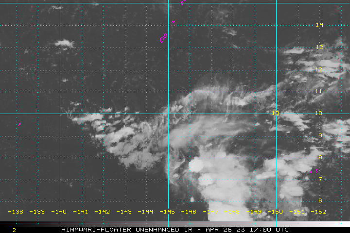
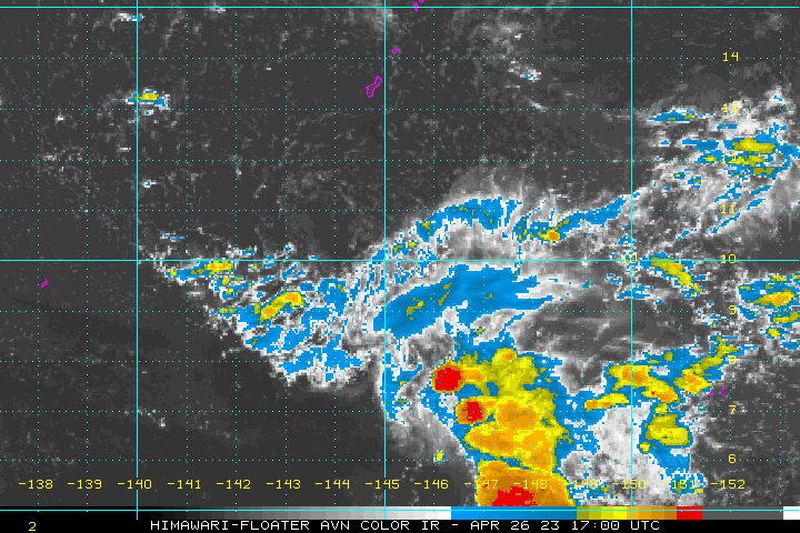
MEKKHALA's upper level structure is almost completely gone. A combination of unfavourable vertical wind shear and sea temperatures will see the storm dissipate by t+24.
米克拉的高層結構幾乎完全消失。在垂直風切變及海溫不利的情況下,風暴將於 24 小時內消散。
Effects on
Hong Kong 對香港的影響
No threat to Hong Kong is expected within the next 72 hours.
預料米克拉於未來的 72 小時將不會對香港構成影響。
Next Update
下次更新
This is the final bulletin on MEKKHALA.
這是本站對米克拉的最後一次發佈。
Other Images
其他圖像
JTWC Track 聯合颱風警報中心路徑圖
JMA Track 日本氣象廳路徑圖
HKO Satellite 香港天文台衛星圖
HKO Track 香港天文台路徑圖
Probabilities
of TC Signals from HKO 香港天文台發出 / 取消熱帶氣旋警告信號的機率
N/A 不適用
Past Bulletins (click on the bulletin no. for the contents) 過往報告
(請按發佈編號顯示內容)
MEKKHALA is the 68th name in the tropical cyclone name list. It was contributed by Thailand, and is the angel of thunder. This name was used in 2002 and 2008.
The subtropical ridge continues to weaken. MEKKHALA is now expected to move NW to NNW along its southwestern periphery, and will meet Luzon's mountain ranges by t+36.
MEKKHALA's structure has deteriorated rapidly since it made landfall at the Philippines. The storm is expected to impact Luzon and its supply of moisture will take another hit. MEKKHALA should weaken into an area of low pressure by t+36.
MEKKHALA intensified quickly into a typhoon and is about to make landfall at eastern Philippines. At 2 pm, MEKKHALA was centred about 610 km (330 NM) ESE of Manila.
MEKKHALA is the 68th name in the tropical cyclone name list. It was contributed by Thailand, and is the angel of thunder. This name was used in 2002 and 2008.
The western edge of the subtropical ridge is weakening. MEKKHALA is expected to move WNW turning to NW along its southwestern periphery. Current forecast calls for a rapid weakening of the storm at the Philippines, after which the system will be subjected to low-level steering. However, some models are depicting an alternative scenario in which MEKKHALA recurves to the northeast near Luzon. There exists substantial uncertainty to MEKKHALA's movement as it reaches northern Philippines.
MEKKHALA intensified substantially over the past 24 hours and the storm is trying to create a banding eye. As MEKKHALA reaches the Philippines, a combination of land interaction and cooler sea temperatures will serve to weaken the storm. It is expected to weaken into an area of low pressure near the time it leaves the Philippines.
MEKKHALA is the 68th name in the tropical cyclone name list. It was contributed by Thailand, and is the angel of thunder. This name was used in 2002 and 2008.
MEKKHALA is expected to move west at reduced speeds due to a slight weakness in the subtropical ridge to the north. A mid-latitude trough is expected to arrive at around t+24, which will erode the ridge and lead to a gradual turn to the NW. Current forecast calls for a rapid weakening of the storm at the Philippines, after which the system will be subjected to low-level steering to the west.
As vertical wind shear relaxes, MEKKHALA is now able to retain spiraling bands although they are still sparse in the eastern semicircle. Some intensification is expected prior to landfall due to favourable sea temperatures. As MEKKHALA reaches the Philippines, a combination of land interaction and cooler sea temperatures will serve to weaken the storm.
MEKKHALA is the 68th name in the tropical cyclone name list. It was contributed by Thailand, and is the angel of thunder. This name was used in 2002 and 2008.
MEKKHALA will move west in the next 36 to 48 hours along the southern periphery of the subtropical ridge. A mid-latitude trough is expected to arrive at around t+48, which will erode the ridge and lead to a gradual poleward turn.
MEKKHALA's cloud bands are tightening, and some intensification is expected due to favourable sea temperatures. As MEKKHALA reaches the Philippines, a combination of land interaction and cooler sea temperatures will serve to weaken the storm.
A tropical disturbance strengthened into tropical depression 01W last night. It intensified into a tropical storm today, and was named MEKKHALA. At 2 pm, MEKKHALA was centred about 95 km (50 NM) NNE of Yap.
MEKKHALA is the 68th name in the tropical cyclone name list. It was contributed by Thailand, and is the angel of thunder. This name was used in 2002 and 2008.
MEKKHALA is expected to move WNW along the southern periphery of the subtropical ridge in the next 24 to 36 hours. Re-orientation of the ridge may lead to a temporary westward deflection at reduced speeds, before the storm resumes WNW movement as the ridge is weakened by a passing trough. There is high uncertainty to the forecast track beyond t+72 due to diverging model outcomes.
MEKKHALA is in an area with moderately strong vertical wind shear, and as a result its convections are clearly sheared to its north. Seas are warm along its forecast track, and some intensification is expected. As MEKKHALA reaches the Philippines, a combination of land interaction and cooler sea temperatures will serve to weaken the storm.
 Active Tropical Cyclone(s) 正活躍之熱帶氣旋