| Forecast
Track ¹w“śøō®|¹Ļ |

|
| Forecast
Positions ¹w“ś¦ģømøź®Ę |
Tau
®É¶”®t |
HK Time
»“ä®É¶” |
Lat.
½n«× |
Long.
øg«× |
Movement
²¾°Ź³t«×©M¤č¦V |
1-min Average Strength
¤@¤ĄÄĮ„§”±j«× |
Distance/Bearing from HK
»P»“äŖŗ¶ZĀ÷©M¤č¦ģؤ |
| t+0 |
04/05 (Sun) 08:00 |
16.3°N
| 122.5°E
| NW ¦č„_ (304°) 21 km/h |
50 kt (93 km/h) |
STS ±jÆP¼ö±a·¼É |
SE ŖF«n 1098 km |
| t+12 |
04/05 (Sun) 20:00 |
17.6°N
| 120.5°E
| NW ¦č„_ (305°) 21 km/h |
40 kt (74 km/h) |
TS ¼ö±a·¼É |
SE ŖF«n 842 km |
| t+24 |
04/06 (Mon) 08:00 |
18.9°N
| 118.5°E
| NW ¦č„_ (306°) 14 km/h |
35 kt (65 km/h) |
TS ¼ö±a·¼É |
SE ŖF«n 588 km |
| t+36 |
04/06 (Mon) 20:00 |
19.8°N
| 117.2°E
| WNW ¦č„_°¾¦č (298°) 10 km/h |
30 kt (56 km/h) |
TD ¼ö±a§C®šĄ£ |
SE ŖF«n 419 km |
| t+48 |
04/07 (Tue) 08:00 |
20.3°N
| 116.2°E
| W ¦č (266°) 6 km/h |
25 kt (46 km/h) |
TD ¼ö±a§C®šĄ£ |
SE ŖF«n 306 km |
| t+72 |
04/08 (Wed) 08:00 |
20.2°N
| 114.9°E
| N/A |
20 kt (37 km/h) |
LPA §CĄ£°Ļ |
SSE ŖF«n°¾«n 245 km |
|
| Overview Į`Äż |
MAYSAK has weakened into a severe tropical storm, and is about to make landfall at Luzon. At 8 am, MAYSAK was centred about 250 km (140 NM) NE of Manila.
¬ü²ļ§J¤w“ī®z¬°±jÆP¼ö±a·¼É”AØƧY±N©ó§f§ŗµn³°”C¦b¤W¤Č 8 ®É”A ¬ü²ļ§J¶°µ²¦b°Ø„§©ŌŖF„_¬ł 250 ¤½Ø½ (140 ®üؽ)”C |
| TC
Naming ®š±Ū©R¦W |
MAYSAK is the 71st name in the tropical cyclone name list. It was contributed by Cambodia, and is a kind of tree. This name was used in 2002 and 2008.
¬ü²ļ§J¬°¼ö±a®š±Ū¦WŗŁ¦CŖķ¤¤²Ä 71 Ó¦W¦r”A„ѬZ®H¹ė“£ØŃ”A¬°¤@ŗŲ¾š¤ģŖŗ¦WŗŁ”C¦¹¦W“æ©ó 2002 ¤Ī 2008 ¦~ØĻ„Ī”C |
| Movement
Analysis øō®|¤ĄŖR |
MAYSAK is expected to move northwest along the southwestern periphery of the subtropical ridge. As a surge of northeast monsoon arrives and MAYSAK weakens, it will decelerate in South China Sea, with a possibility of deflecting to the west as it degenerates.
¬ü²ļ§J±NŖu°Ę¼ö±a°ŖĄ£Æį¦č«n³”¦V¦č„_²¾°Ź”CĄHµŪ¤@ŖŃŖF„_©uŌ·ŖŗØģØÓ”A¬ü²ļ§J±N©ó«n®ü“ī®z¤Ī“ī³t”A«į“Į·¼É®ų“²®É©Ī·|¦čÄĘ”C |
| Intensity
Analysis ±j«×¤ĄŖR |
Current T-number ²{®ÉŖŗ T ø¹½X: T3.0/3.5/W1.0/24 HRS
MAYSAK's appearance continued to deteriorate and the storm looks fairly disorganized. It will weaken appreciably as it crosses Luzon, and with stronger vertical wind shear and the entrainment of cool, dry air from the northeast monsoon in South China Sea, MAYSAK is expected to dissipate by t+72, before it could reach southern Chinese coast.
¬ü²ļ§JŖŗµ²ŗcÄ~ÄņĀą®t”A·¼ÉÆŹ„F²ÕĀ“”C¬ü²ļ§J±N©ó¾ī¹L§f§ŗ®É©śÅć“ī®z”A¦ÓØüøū±j««Ŗ½·¤ĮÅܼvÅT¤ĪŖF„_©uŌ·³y¦Ø°®§NŖÅ®š¤J«I”A·¼É±N©ó 72 ¤p®É¤ŗ®ų“²”A„¼ÆąØģ¹FµŲ«nŖu©¤”C |
| Effects on
Hong Kong ¹ļ»“äŖŗ¼vÅT |
A surge of northeast monsoon is due to arrive on Tuesday, when MAYSAK is in the South China Sea. Winds will strengthen from the east, but MAYSAK should weaken quickly enough not to cause major disruption to the territory.
©ó¬ü²ļ§J¾ī¹L«n®üŖŗ¦P®É”A¹w®Ę¤@ŖŃŖF„_©uŌ·±N©ó©P¤GØģ¹F”A©”®ÉŖF··|¼W±j”C„Ń©ó¹w“ś¬ü²ļ§J“ī®z³t«×»į§Ö”A„¦Ą³øÓ¤£·|¹ļ»“äŗc¦ØÄY«¼vÅT”C |
| Next Update
¤U¦ø§ó·s |
2015/04/06 (Mon ¤@), afternoon ¤U¤Č (or earlier ©Ī§ó¦) |
| Other Images
Øä„L¹Ļ¹³ |
JTWC Track Įp¦X»ä·Äµ³ų¤¤¤ßøō®|¹Ļ |
|
JMA Track ¤é„»®š¶HĘUøō®|¹Ļ |
|
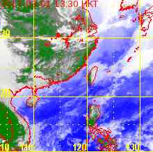
HKO Satellite »“ä¤Ń¤å„x½Ć¬P¹Ļ |
|
HKO Track »“ä¤Ń¤å„xøō®|¹Ļ |
|
|
| Probabilities
of TC Signals from HKO within the next 3 days „¼ØÓ¤T¤Ń»“ä¤Ń¤å„xµo„X / Øś®ų¼ö±a®š±Ūĵ§i«Hø¹Ŗŗ¾÷²v |
Signal «Hø¹ |
t+12 |
t+24 |
t+36 |
t+48 |
t+60 |
t+72 |
| Standby §Ł³Ę #1 |
|
Low §C |
Medium ¤¤µ„ |
Medium ¤¤µ„ |
Low §C |
|
| Strong Wind ±j· #3 |
|
|
|
|
|
|
| Gale/Storm ÆP©Ī¼É· #8 |
|
|
|
|
|
|
| G/S Incr. ÆP©Ī¼É·¼W±j #9 |
|
|
|
|
|
|
| Hurricane Įü· #10 |
|
|
|
|
|
|
Notes µł:
1) For issuance, "Signal" column represents having issued that signal or above. ¦³Ćöµo„X¾÷²v”AŗÄę«ü¤wµo„XøÓ«Hø¹©Ī§ó°Ŗ«Hø¹”C
2) "Low" = Probability from 5 to 20 per cent; "Medium" = 20 to 50%; "High" = 50 to 80%; "V High" = 80% or above.
"§C" = 5% - 20% Ŗŗ¾÷²v; "¤¤µ„" = 20 - 50%; "°Ŗ" = 50 - 80%; "·„°Ŗ" = 80% ©Ī„H¤W”C |
 Active Tropical Cyclone(s) „欔ÅD¤§¼ö±a®š±Ū