TC Watch / 熱帶氣旋 > Latest TC Info 最新熱帶氣旋資訊 [Refresh 更新]

Quick links 快速連結: Current Storm Info 實時氣旋資料 Past Storm Info 過去氣旋資料
HKO Storm Info 天文台之熱帶氣旋資訊 TC Archive 熱帶氣旋資料庫
Official TC Track Info 官方熱帶氣旋路徑資料 Selected TC Review 重要熱帶氣旋回顧
Tracks from Non-Governmental Agencies 民辦網站預測路徑圖 TC Finder 熱帶氣旋尋找工具
Active Tropical Cyclone(s) 正活躍之熱帶氣旋

Current TC Map 即時氣旋資訊Current TC information

Tropical Cyclone Report 熱帶氣旋報告 [Our partner site's TC update 按此看友站的氣旋動態報告]

2. 10W (LINFA 蓮花)

Name of System 系統名稱

TD LINFA 熱帶低氣壓 蓮花


JTWC No. / Int'l No. JTWC 編號 / 國際編號 10W / 1510
Bulletin Number 發佈編號 #10 FINAL BULLETIN 最後發佈
Time of Report 報告時間

2015/07/10, 13:00 HKT (05:00 UTC)

Time of Observation 觀測時間 2015/07/10, 08:00 HKT (00:00 UTC)
Position 位置 22.1°N, 111.7°E
Maximum Gust 最高陣風 35 knots 節 (65 km/h 公里每小時)
1-min. Average Wind Speed 1分鐘平均風速 25 knots 節 (45 km/h 公里每小時)
10-min. Average Wind Speed 10分鐘平均風速 20 knots 節 (35 km/h 公里每小時)
Pressure 氣壓 1000 hPa 百帕斯卡
Past 6-hr Movement 過去6小時移向和移速 WSW 西南偏西 (249°) at 11 knots 節 (20 km/h 公里每小時)
Area(s) affected 受影響地區 Coastal Guangdong 廣東沿岸

Forecast Track 預測路徑圖

Forecast Positions 預測位置資料

Tau
時間差
HK Time
香港時間
Lat.
緯度
Long.
經度
Movement
移動速度和方向
1-min Average Strength
一分鐘平均強度
Distance/Bearing from HK
與香港的距離和方位角
t+007/10 (Fri) 08:0022.1°N111.7°ESW 西南 (229°) 11 km/h25 kt (46 km/h)TD 熱帶低氣壓W 西 255 km
t+1207/10 (Fri) 20:0021.3°N110.7°EN/A20 kt (37 km/h)LPA 低壓區WSW 西南偏西 375 km
Overview 總覽

LINFA continues to weaken as it moves across land. At 8 am, LINFA was centred about 260 km (140 NM) W of Hong Kong. All tropical cyclone signals were cancelled at 5:50 am.

蓮花繼續於陸上減弱。在上午 8 時,蓮花集結在香港以西約 260 公里 (140 海里)。所有熱帶氣旋警告信號已於上午 5 時 50 分解除。

TC Naming 氣旋命名

LINFA is the 77th name in the tropical cyclone name list. It was contributed by Macau, meaning lotus. This name was used in 2003 and 2009; the latter necessitated the #1 Standby Signal in Hong Kong.

蓮花為熱帶氣旋名稱列表中第 77 個名字,由澳門提供。此名曾於 2003 及 2009 年使用,後者令天文台發出一號戒備信號。

Movement Analysis 路徑分析

LINFA will decelerate and move SW to WSW in the next 12 hours.

蓮花將於未來 12 小時減速向西南或西南偏西移動。

Intensity Analysis 強度分析

Current T-number 現時的 T 號碼: N/A 不適用

LINFA's convections have become very loose and the storm is losing cyclonic circulation. Dissipation is expected in the near term.

蓮花的對流變得非常鬆散,風暴逐漸失去氣旋式對流。預料風暴將於短期內消散。

Effects on Hong Kong 對香港的影響

As LINFA weakens, local weather will improve during the weekend.

隨著蓮花減弱,本港天氣將於周末好轉。

Next Update 下次更新

This is the final bulletin on LINFA.

這是本站對蓮花的最後一次發佈。

Other Images 其他圖像
JTWC Track 聯合颱風警報中心路徑圖
JMA Track 日本氣象廳路徑圖
HKO Satellite 香港天文台衛星圖
HKO Track 香港天文台路徑圖
Probabilities of TC Signals from HKO within the next 3 days 未來三天香港天文台發出 / 取消熱帶氣旋警告信號的機率
N/A 不適用

Past Bulletins (click on the bulletin no. for the contents) 過往報告 (請按發佈編號顯示內容)

+10W (LINFA 蓮花) Bulletin 發佈 #9 (2015/07/10, 00:45 HKT)

Name of System 系統名稱

TD LINFA 熱帶低氣壓 蓮花


JTWC No. / Int'l No. JTWC 編號 / 國際編號 10W / 1510
Bulletin Number 發佈編號 #9
Time of Report 報告時間

2015/07/10, 00:45 HKT (07/09 16:45 UTC)

Time of Observation 觀測時間 2015/07/09, 23:00 HKT (15:00 UTC)
Position 位置 22.6°N, 113.7°E
Maximum Gust 最高陣風 40 knots 節 (75 km/h 公里每小時)
1-min. Average Wind Speed 1分鐘平均風速 30 knots 節 (55 km/h 公里每小時)
10-min. Average Wind Speed 10分鐘平均風速 25 knots 節 (45 km/h 公里每小時)
Pressure 氣壓 994 hPa 百帕斯卡
Past 6-hr Movement 過去6小時移向和移速 WSW 西南偏西 (250°) at 6 knots 節 (11 km/h 公里每小時)
Area(s) affected 受影響地區 Coastal Guangdong 廣東沿岸

Forecast Track 預測路徑圖

Forecast Positions 預測位置資料

Tau
時間差
HK Time
香港時間
Lat.
緯度
Long.
經度
Movement
移動速度和方向
1-min Average Strength
一分鐘平均強度
Distance/Bearing from HK
與香港的距離和方位角
t+0 07/09 (Thu) 23:00 22.6°N 113.7°E WSW 西南偏西 (245°) 15 km/h 30 kt (56 km/h) TD 熱帶低氣壓 NW 西北 59 km
t+12 07/10 (Fri) 11:00 21.9°N 112.1°E SW 西南 (230°) 10 km/h 25 kt (46 km/h) TD 熱帶低氣壓 W 西 218 km
t+24 07/10 (Fri) 23:00 21.2°N 111.2°E N/A 20 kt (37 km/h) LPA 低壓區 WSW 西南偏西 330 km
Overview 總覽

LINFA weakened rapidly on land despite its proximity to the sea, and is now a tropical depression. At 11 pm last night, LINFA was centred about 60 km (30 NM) NW of Hong Kong. The #8 NW Gale or Storm Signal was in force between 4:40 pm and 10:10 pm yesterday, but has since been replaced by the #3 Strong Wind Signal.

雖然蓮花離岸邊不遠,但仍然於陸上快速減弱,現時只餘熱帶低氣壓強度。在昨晚 11 時,蓮花集結在香港西北約 60 公里 (30 海里)。八號西北烈風或暴風信號曾於昨下午 4 時 40 分至 10 時 10 分生效,但其後已被三號強風信號取代。

TC Naming 氣旋命名

LINFA is the 77th name in the tropical cyclone name list. It was contributed by Macau, meaning lotus. This name was used in 2003 and 2009; the latter necessitated the #1 Standby Signal in Hong Kong.

蓮花為熱帶氣旋名稱列表中第 77 個名字,由澳門提供。此名曾於 2003 及 2009 年使用,後者令天文台發出一號戒備信號。

Movement Analysis 路徑分析

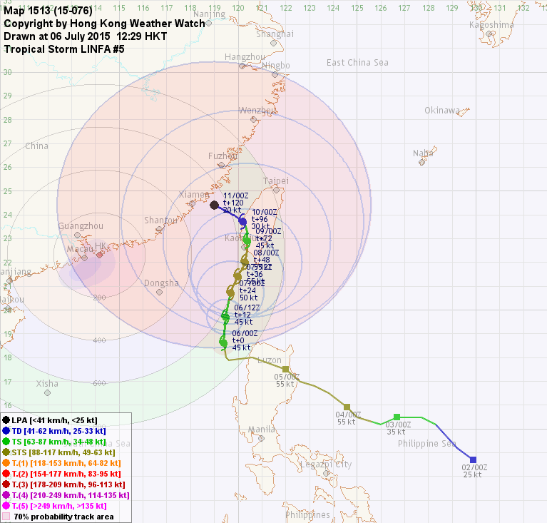
LINFA is gradually losing latitude, and is expected to move WSW to SW before dissipation.

蓮花緯度降低,預料將於消散前向西南偏西或西南移動。

Intensity Analysis 強度分析

Current T-number 現時的 T 號碼: N/A 不適用

LINFA's convective bands are disintegrating; this is particularly prominent in its southern semicircle. As CHAN-HOM nears, atmospheric environment will deteriorate and LINFA will weaken into an area of low pressure even if it manages to return to the sea.

蓮花的對流逐漸消失,尤以其南半圓為甚。隨著燦鴻靠近,蓮花附近的大氣環境將進一步轉差,即使風暴能再次進入海洋亦預計會減弱為低壓區。

Effects on Hong Kong 對香港的影響

LINFA weakened quickly and local conditions were not as bad as predicted even though LINFA is still very close to Hong Kong. Winds have already subsided, but showers may continue to affect the territory today with occassional strong gusts. As LINFA moves away and further weakens, the weather will improve during the weekend.

蓮花快速減弱,雖然它仍然非常接近香港,本地的天氣未有預期般差。多區風力已經下降,但預料今日仍會受驟雨影響,間中會有強陣風。隨著蓮花移離並進一步減弱,本港天氣將於周末好轉。

Next Update 下次更新

2015/07/10 (Fri 五), afternoon 下午 (or earlier 或更早)

Other Images 其他圖像
JTWC Track 聯合颱風警報中心路徑圖
JMA Track 日本氣象廳路徑圖
HKO Satellite 香港天文台衛星圖
HKO Track 香港天文台路徑圖
Probabilities of TC Signals from HKO within the next 3 days 未來三天香港天文台發出 / 取消熱帶氣旋警告信號的機率
Signal 信號
t+12
t+24
t+36
t+48
t+60
t+72
Standby 戒備 #1 (Cnl. 取消) Medium 中等 High 高 Very High 極高 Very High 極高 Very High 極高 Very High 極高
Strong Wind 強風 #3 (Cnl. 取消) High 高 Very High 極高 Very High 極高 Very High 極高 Very High 極高 Very High 極高
Gale/Storm 烈或暴風 #8            
G/S Incr. 烈或暴風增強 #9            
Hurricane 颶風 #10            

Notes 註:
1) For issuance, "Signal" column represents having issued that signal or above. 有關發出機率,首欄指已發出該信號或更高信號。
2) "Low" = Probability from 5 to 20 per cent; "Medium" = 20 to 50%; "High" = 50 to 80%; "V High" = 80% or above.
"低" = 5% - 20% 的機率; "中等" = 20 - 50%; "高" = 50 - 80%; "極高" = 80% 或以上。

+10W (LINFA 蓮花) Bulletin 發佈 #8 (2015/07/09, 12:45 HKT)

Name of System 系統名稱

TY (CAT. 1) LINFA 一級颱風 蓮花


JTWC No. / Int'l No. JTWC 編號 / 國際編號 10W / 1510
Bulletin Number 發佈編號 #8
Time of Report 報告時間

2015/07/09, 12:45 HKT (04:45 UTC)

Time of Observation 觀測時間 2015/07/09, 08:00 HKT (00:00 UTC)
Position 位置 22.7°N, 116.8°E
Maximum Gust 最高陣風 80 knots 節 (150 km/h 公里每小時)
1-min. Average Wind Speed 1分鐘平均風速 70 knots 節 (130 km/h 公里每小時)
10-min. Average Wind Speed 10分鐘平均風速 65 knots 節 (120 km/h 公里每小時)
Pressure 氣壓 965 hPa 百帕斯卡
Past 6-hr Movement 過去6小時移向和移速 WNW 西北偏西 (284°) at 9 knots 節 (16 km/h 公里每小時)
Area(s) affected 受影響地區 Eastern Guangdong 廣東東部

Forecast Track 預測路徑圖

Forecast Positions 預測位置資料

Tau
時間差
HK Time
香港時間
Lat.
緯度
Long.
經度
Movement
移動速度和方向
1-min Average Strength
一分鐘平均強度
Distance/Bearing from HK
與香港的距離和方位角
t+0 07/09 (Thu) 08:00 22.7°N 116.8°E W 西 (270°) 18 km/h 70 kt (130 km/h) TY (Cat. 1) 一級颱風 E 東 274 km
t+12 07/09 (Thu) 20:00 22.7°N 114.7°E WSW 西南偏西 (256°) 15 km/h 60 kt (111 km/h) STS 強烈熱帶風暴 NE 東北 70 km
t+24 07/10 (Fri) 08:00 22.3°N 113.0°E SW 西南 (236°) 11 km/h 45 kt (83 km/h) TS 熱帶風暴 W 西 120 km
t+36 07/10 (Fri) 20:00 21.6°N 111.9°E SW 西南 (219°) 8 km/h 35 kt (65 km/h) TS 熱帶風暴 WSW 西南偏西 247 km
t+48 07/11 (Sat) 08:00 20.9°N 111.3°E S 南 (180°) 6 km/h 30 kt (56 km/h) TD 熱帶低氣壓 WSW 西南偏西 335 km
t+72 07/12 (Sun) 08:00 19.7°N 111.3°E N/A 20 kt (37 km/h) LPA 低壓區 SW 西南 415 km
Overview 總覽

LINFA has intensified into a typhoon, and has just made landfall near Lufeng. At 8 am, LINFA was centred about 270 km (150 NM) E of Hong Kong. The Observatory issued the #3 Strong Wind Signal at 8:40 am today.

蓮花增強為颱風,並剛於陸豐一帶登陸。在上午 8 時,蓮花集結在香港以東約 270 公里 (150 海里)。天文台於今早 8 時 40 分改發三號強風信號。

TC Naming 氣旋命名

LINFA is the 77th name in the tropical cyclone name list. It was contributed by Macau, meaning lotus. This name was used in 2003 and 2009; the latter necessitated the #1 Standby Signal in Hong Kong.

蓮花為熱帶氣旋名稱列表中第 77 個名字,由澳門提供。此名曾於 2003 及 2009 年使用,後者令天文台發出一號戒備信號。

Movement Analysis 路徑分析

LINFA will move W to WSW across coastal Guangdong, and may later turn south into South China Sea again under CHAN-HOM's influence.

蓮花將向西或西南偏西移動,橫過廣東沿岸。隨後因燦鴻的影響,蓮花或會再次進入南海。

Intensity Analysis 強度分析

Current T-number 現時的 T 號碼: T4.0/4.0/D0.5/24 HRS

LINFA's eye appeared tight on radar images prior to landfall, but was filled soon afterwards. It is expected to weaken gradually due to friction on land. CHAN-HOM's approach to eastern China will limit LINFA's outflow channels, causing it to dissipate near t+72.

從雷達圖上可見蓮花的風眼於登陸前頗為緊密,但登陸後被快速填塞。受陸地摩擦力影響,風暴將逐漸減弱。燦鴻稍後靠近華東,蓮花的輻散將受限制,並於約 72 小時後消散。

Effects on Hong Kong 對香港的影響

LINFA is expected to reach the Pearl River Estuary tonight. Due to LINFA's tight structure, local winds will surge rapidly this afternoon, blowing in from the northwest, gradually backing to the southwest as LINFA passes to the north. The weather will deteriorate in the next few hours; precautionary measures should be completed as soon as possible.

預料蓮花將於今晚到達珠江口。由於蓮花結構緊密,本地西北風將於下午急速增強,並隨蓮花於香港以北掠過而逐漸逆轉為西南風。本港天氣將於未來數小時轉壞,市民應盡快完成防風措施。

Next Update 下次更新

2015/07/10 (Fri 五), early morning 清晨 (or earlier 或更早)

Other Images 其他圖像
JTWC Track 聯合颱風警報中心路徑圖
JMA Track 日本氣象廳路徑圖
HKO Satellite 香港天文台衛星圖
HKO Track 香港天文台路徑圖
Probabilities of TC Signals from HKO within the next 3 days 未來三天香港天文台發出 / 取消熱帶氣旋警告信號的機率
Signal 信號
t+12
t+24
t+36
t+48
t+60
t+72
Standby 戒備 #1 (Cnl. 取消)     Low 低 Medium 中等 High 高 High 高
Strong Wind 強風 #3 (Cnl. 取消)     Medium 中等 High 高 High 高 Very High 極高
Gale/Storm 烈或暴風 #8 Very High 極高 Medium 中等 Low 低      
G/S Incr. 烈或暴風增強 #9 Medium 中等          
Hurricane 颶風 #10 Low 低          

Notes 註:
1) For issuance, "Signal" column represents having issued that signal or above. 有關發出機率,首欄指已發出該信號或更高信號。
2) "Low" = Probability from 5 to 20 per cent; "Medium" = 20 to 50%; "High" = 50 to 80%; "V High" = 80% or above.
"低" = 5% - 20% 的機率; "中等" = 20 - 50%; "高" = 50 - 80%; "極高" = 80% 或以上。

+10W (LINFA 蓮花) Bulletin 發佈 #7 (2015/07/08, 13:00 HKT)

Name of System 系統名稱

STS LINFA 強烈熱帶風暴 蓮花


JTWC No. / Int'l No. JTWC 編號 / 國際編號 10W / 1510
Bulletin Number 發佈編號 #7
Time of Report 報告時間

2015/07/08, 13:00 HKT (05:00 UTC)

Time of Observation 觀測時間 2015/07/08, 08:00 HKT (00:00 UTC)
Position 位置 21.5°N, 118.7°E
Maximum Gust 最高陣風 70 knots 節 (130 km/h 公里每小時)
1-min. Average Wind Speed 1分鐘平均風速 60 knots 節 (110 km/h 公里每小時)
10-min. Average Wind Speed 10分鐘平均風速 55 knots 節 (100 km/h 公里每小時)
Pressure 氣壓 980 hPa 百帕斯卡
Past 6-hr Movement 過去6小時移向和移速 N 北 (360°) at 3 knots 節 (6 km/h 公里每小時)
Area(s) affected 受影響地區 Northeastern South China Sea 南海東北部

Forecast Track 預測路徑圖

Forecast Positions 預測位置資料

Tau
時間差
HK Time
香港時間
Lat.
緯度
Long.
經度
Movement
移動速度和方向
1-min Average Strength
一分鐘平均強度
Distance/Bearing from HK
與香港的距離和方位角
t+0 07/08 (Wed) 08:00 21.5°N 118.7°E NNW 西北偏北 (328°) 10 km/h 60 kt (111 km/h) STS 強烈熱帶風暴 E 東 475 km
t+12 07/08 (Wed) 20:00 22.4°N 118.1°E NW 西北 (308°) 12 km/h 65 kt (120 km/h) TY (Cat. 1) 一級颱風 E 東 404 km
t+24 07/09 (Thu) 08:00 23.2°N 117.0°E W 西 (270°) 16 km/h 60 kt (111 km/h) STS 強烈熱帶風暴 ENE 東北偏東 307 km
t+36 07/09 (Thu) 20:00 23.2°N 115.1°E WSW 西南偏西 (254°) 16 km/h 45 kt (83 km/h) TS 熱帶風暴 NE 東北 138 km
t+48 07/10 (Fri) 08:00 22.7°N 113.3°E WSW 西南偏西 (245°) 14 km/h 35 kt (65 km/h) TS 熱帶風暴 WNW 西北偏西 100 km
t+72 07/11 (Sat) 08:00 21.4°N 110.4°E N/A 20 kt (37 km/h) LPA 低壓區 WSW 西南偏西 401 km
Overview 總覽

LINFA continued to move north slowly over the past 24 hours. At 8 am, LINFA was centred about 480 km (260 NM) E of Hong Kong. The Observatory issued the #1 Standby Signal at 7:40 am.

蓮花於過去 24 小時繼續向北緩慢移動。在上午 8 時,蓮花集結在香港以東約 480 公里 (260 海里)。天文台於今早 7 時 40 分發出一號戒備信號。

TC Naming 氣旋命名

LINFA is the 77th name in the tropical cyclone name list. It was contributed by Macau, meaning lotus. This name was used in 2003 and 2009; the latter necessitated the #1 Standby Signal in Hong Kong.

蓮花為熱帶氣旋名稱列表中第 77 個名字,由澳門提供。此名曾於 2003 及 2009 年使用,後者令天文台發出一號戒備信號。

Movement Analysis 路徑分析

A ridge is building in China. LINFA will be steered by this ridge and gradually turn west, making landfall at eastern Guangdong. It is then expected to track W or WSW across coastal Guangdong.

一脊場正於中國建立,預料蓮花將受該脊帶動,逐漸西移並於廣東東部登陸,隨後向西或西南偏西移動,橫過廣東沿岸。

Intensity Analysis 強度分析

Current T-number 現時的 T 號碼: T3.5/3.5/D0.5/24 HRS

LINFA intensified slightly over the past 24 hours, and appears to be forming an eye on satellite images. It may reach typhoon intensity prior to landfall, but will weaken quickly on land.

蓮花於過去 24 小時稍為增強,從衛星雲圖上看似乎正建立一風眼。它有機會於登陸前增強為颱風,但會於陸上快速減弱。

Effects on Hong Kong 對香港的影響

As LINFA comes closer, local weather is expected to deteriorate later tomorrow, with squally showers becoming frequent. Westerly winds will prevail, turning to southwest near the weekend. Its effect on Hong Kong depends on how soon it starts its westward turn, as that will determine when will LINFA start to weaken and how close it will reach.

隨著蓮花靠近,本港天氣將於明日較後時間轉壞,驟雨將漸轉頻密,並吹西風,於周末漸轉西南風。蓮花對香港的影響取決於其西折的時間,因這將決定它何時開始減弱,以及它與哪裡掠過本港。

Next Update 下次更新

2015/07/09 (Thu 四), afternoon 下午 (or earlier 或更早)

Other Images 其他圖像
JTWC Track 聯合颱風警報中心路徑圖
JMA Track 日本氣象廳路徑圖
HKO Satellite 香港天文台衛星圖
HKO Track 香港天文台路徑圖
Probabilities of TC Signals from HKO within the next 3 days 未來三天香港天文台發出 / 取消熱帶氣旋警告信號的機率
Signal 信號
t+12
t+24
t+36
t+48
t+60
t+72
Standby 戒備 #1 (Cnl. 取消)     Low 低 Low 低 Medium 中等 High 高
Strong Wind 強風 #3   Low 低 Medium 中等 High 高 Medium 中等 Low 低
Gale/Storm 烈或暴風 #8     Low 低 Medium 中等 Low 低  
G/S Incr. 烈或暴風增強 #9            
Hurricane 颶風 #10            

Notes 註:
1) For issuance, "Signal" column represents having issued that signal or above. 有關發出機率,首欄指已發出該信號或更高信號。
2) "Low" = Probability from 5 to 20 per cent; "Medium" = 20 to 50%; "High" = 50 to 80%; "V High" = 80% or above.
"低" = 5% - 20% 的機率; "中等" = 20 - 50%; "高" = 50 - 80%; "極高" = 80% 或以上。

+10W (LINFA 蓮花) Bulletin 發佈 #6 (2015/07/07, 13:15 HKT)

Name of System 系統名稱

STS LINFA 強烈熱帶風暴 蓮花


JTWC No. / Int'l No. JTWC 編號 / 國際編號 10W / 1510
Bulletin Number 發佈編號 #6
Time of Report 報告時間

2015/07/07, 13:15 HKT (05:15 UTC)

Time of Observation 觀測時間 2015/07/07, 08:00 HKT (00:00 UTC)
Position 位置 20.2°N, 119.2°E
Maximum Gust 最高陣風 60 knots 節 (110 km/h 公里每小時)
1-min. Average Wind Speed 1分鐘平均風速 50 knots 節 (95 km/h 公里每小時)
10-min. Average Wind Speed 10分鐘平均風速 45 knots 節 (85 km/h 公里每小時)
Pressure 氣壓 985 hPa 百帕斯卡
Past 6-hr Movement 過去6小時移向和移速 NNW 西北偏北 (343°) at 3 knots 節 (6 km/h 公里每小時)
Area(s) affected 受影響地區 Luzon Strait 呂宋海峽

Forecast Track 預測路徑圖

Forecast Positions 預測位置資料

Tau
時間差
HK Time
香港時間
Lat.
緯度
Long.
經度
Movement
移動速度和方向
1-min Average Strength
一分鐘平均強度
Distance/Bearing from HK
與香港的距離和方位角
t+0 07/07 (Tue) 08:00 20.2°N 119.2°E N 北 (354°) 8 km/h 50 kt (93 km/h) STS 強烈熱帶風暴 ESE 東南偏東 571 km
t+12 07/07 (Tue) 20:00 21.1°N 119.1°E NNW 西北偏北 (348°) 9 km/h 55 kt (102 km/h) STS 強烈熱帶風暴 ESE 東南偏東 526 km
t+24 07/08 (Wed) 08:00 22.0°N 118.9°E NW 西北 (324°) 12 km/h 60 kt (111 km/h) STS 強烈熱帶風暴 E 東 488 km
t+36 07/08 (Wed) 20:00 23.0°N 118.1°E WNW 西北偏西 (303°) 15 km/h 55 kt (102 km/h) STS 強烈熱帶風暴 ENE 東北偏東 410 km
t+48 07/09 (Thu) 08:00 23.9°N 116.6°E W 西 (273°) 15 km/h 45 kt (83 km/h) TS 熱帶風暴 NE 東北 305 km
t+72 07/10 (Fri) 08:00 24.0°N 113.1°E N/A 20 kt (37 km/h) LPA 低壓區 NNW 西北偏北 218 km
Overview 總覽

LINFA is moving north slowly as it reintensifies into a severe tropical storm. At 8 am, LINFA was centred about 570 km (310 NM) ESE of Hong Kong.

蓮花向北緩慢移動,並再度增強為強烈熱帶風暴。在上午 8 時,蓮花集結在香港東南偏東約 570 公里 (310 海里)。

TC Naming 氣旋命名

LINFA is the 77th name in the tropical cyclone name list. It was contributed by Macau, meaning lotus. This name was used in 2003 and 2009; the latter necessitated the #1 Standby Signal in Hong Kong.

蓮花為熱帶氣旋名稱列表中第 77 個名字,由澳門提供。此名曾於 2003 及 2009 年使用,後者令天文台發出一號戒備信號。

Movement Analysis 路徑分析

With the lack of a clear steering environment, LINFA is drifting north slowly. There are indications that the subtropical ridge will extend to the west soon, causing LINFA to deflect to the west before CHAN-HOM comes close to eastern China. It will also accelerate when the steering flow strengthens.

由於缺乏明顯流場,蓮花正緩慢北移。有跡象顯示副熱帶高壓脊將於短期內重新西伸,令蓮花得以於燦鴻靠近華東前西折,並因流場增強而加速。

Intensity Analysis 強度分析

Current T-number 現時的 T 號碼: T3.0/3.0/D0.5/24 HRS

LINFA's convections align with the low-level circulation centre again. The storm is expected to intensify slightly in the next 24 hours, before weakening again as it reaches Fujian. It will weaken rapidly on land.

蓮花的對流與低層環流中心對齊,預料將於未來 24 小時稍為增強,其後因靠近福建而開始減弱。預料蓮花將於陸上快速減弱。

Effects on Hong Kong 對香港的影響

According to the present forecast track, winds in Hong Kong will turn northwest in the next two days. As LINFA comes closer on Thursday and Friday, showers are expected at that time. Its effect on Hong Kong depends on how soon it starts its westward turn, as that will determine when will LINFA start to weaken.

按照目前預測路徑,香港風向將於未來兩天轉為西北。隨著蓮花於周四及周五靠近,驟雨將漸轉頻密。蓮花對香港的影響取決於其西折的時間,因這將決定它何時開始減弱。

Next Update 下次更新

2015/07/08 (Wed 三), afternoon 下午 (or earlier 或更早)

Other Images 其他圖像
JTWC Track 聯合颱風警報中心路徑圖
JMA Track 日本氣象廳路徑圖
HKO Satellite 香港天文台衛星圖
HKO Track 香港天文台路徑圖
Probabilities of TC Signals from HKO within the next 3 days 未來三天香港天文台發出 / 取消熱帶氣旋警告信號的機率
Signal 信號
t+12
t+24
t+36
t+48
t+60
t+72
Standby 戒備 #1 Low 低 Medium 中等 Medium 中等 High 高 High 高 Medium 中等
Strong Wind 強風 #3       Low 低 Medium 中等 Low 低
Gale/Storm 烈或暴風 #8            
G/S Incr. 烈或暴風增強 #9            
Hurricane 颶風 #10            

Notes 註:
1) For issuance, "Signal" column represents having issued that signal or above. 有關發出機率,首欄指已發出該信號或更高信號。
2) "Low" = Probability from 5 to 20 per cent; "Medium" = 20 to 50%; "High" = 50 to 80%; "V High" = 80% or above.
"低" = 5% - 20% 的機率; "中等" = 20 - 50%; "高" = 50 - 80%; "極高" = 80% 或以上。

+10W (LINFA 蓮花) Bulletin 發佈 #5 (2015/07/06, 12:15 HKT)

Name of System 系統名稱

TS LINFA 熱帶風暴 蓮花


JTWC No. / Int'l No. JTWC 編號 / 國際編號 10W / 1510
Bulletin Number 發佈編號 #5
Time of Report 報告時間

2015/07/06, 12:15 HKT (04:15 UTC)

Time of Observation 觀測時間 2015/07/06, 08:00 HKT (00:00 UTC)
Position 位置 18.6°N, 119.4°E
Maximum Gust 最高陣風 55 knots 節 (100 km/h 公里每小時)
1-min. Average Wind Speed 1分鐘平均風速 45 knots 節 (85 km/h 公里每小時)
10-min. Average Wind Speed 10分鐘平均風速 40 knots 節 (75 km/h 公里每小時)
Pressure 氣壓 990 hPa 百帕斯卡
Past 6-hr Movement 過去6小時移向和移速 N 北 (351°) at 6 knots 節 (11 km/h 公里每小時)
Area(s) affected 受影響地區 Luzon Strait 呂宋海峽

Forecast Track 預測路徑圖

Forecast Positions 預測位置資料

Tau
時間差
HK Time
香港時間
Lat.
緯度
Long.
經度
Movement
移動速度和方向
1-min Average Strength
一分鐘平均強度
Distance/Bearing from HK
與香港的距離和方位角
t+0 07/06 (Mon) 08:00 18.6°N 119.4°E N 北 (005°) 10 km/h 45 kt (83 km/h) TS 熱帶風暴 SE 東南 682 km
t+12 07/06 (Mon) 20:00 19.7°N 119.5°E N 北 (011°) 9 km/h 45 kt (83 km/h) TS 熱帶風暴 ESE 東南偏東 624 km
t+24 07/07 (Tue) 08:00 20.7°N 119.7°E NNE 東北偏北 (022°) 7 km/h 50 kt (93 km/h) STS 強烈熱帶風暴 ESE 東南偏東 599 km
t+36 07/07 (Tue) 20:00 21.4°N 120.0°E NNE 東北偏北 (025°) 6 km/h 55 kt (102 km/h) STS 強烈熱帶風暴 E 東 610 km
t+48 07/08 (Wed) 08:00 22.0°N 120.3°E N 北 (006°) 4 km/h 55 kt (102 km/h) STS 強烈熱帶風暴 E 東 632 km
t+72 07/09 (Thu) 08:00 22.9°N 120.4°E NNW 西北偏北 (347°) 4 km/h 45 kt (83 km/h) TS 熱帶風暴 E 東 643 km
t+96 07/10 (Fri) 08:00 23.7°N 120.2°E WNW 西北偏西 (303°) 6 km/h 30 kt (56 km/h) TD 熱帶低氣壓 ENE 東北偏東 636 km
t+120 07/11 (Sat) 08:00 24.4°N 119.0°E N/A 20 kt (37 km/h) LPA 低壓區 ENE 東北偏東 545 km
Overview 總覽

LINFA turned north last night, and weakened into a tropical storm today. At 8 am, LINFA was centred about 460 km (250 NM) SSW of Kaohsiung.

蓮花昨晚轉為北移,今天減弱為熱帶風暴。在上午 8 時,蓮花集結在高雄西南偏南約 460 公里 (250 海里)。

TC Naming 氣旋命名

LINFA is the 77th name in the tropical cyclone name list. It was contributed by Macau, meaning lotus. This name was used in 2003 and 2009; the latter necessitated the #1 Standby Signal in Hong Kong.

蓮花為熱帶氣旋名稱列表中第 77 個名字,由澳門提供。此名曾於 2003 及 2009 年使用,後者令天文台發出一號戒備信號。

Movement Analysis 路徑分析

LINFA is expected to move N or NNE along the western periphery of the subtropical ridge in the next 48 hours. Thereafter, CHAN-HOM's approach introduces much uncertainty to its track, while more numerical models are suggesting a deflection back to the west. Our forecast track has therefore been adjusted accordingly.

預料蓮花將於未來 48 小時沿副熱帶高壓脊西部向北或東北偏北移動。其後燦鴻靠近令蓮花的路徑充滿變數。逐漸開始有數值預報模式預計蓮花會於後期西折,本網的預報因此相應作出調整。

Intensity Analysis 強度分析

Current T-number 現時的 T 號碼: T2.5/3.0/W1.0/24 HRS

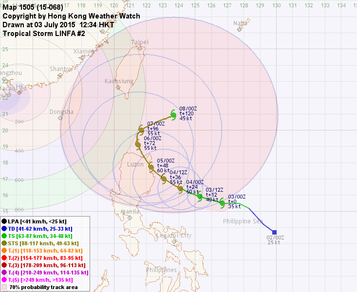
Proximity to Luzon and heightened shear have caused LINFA to weaken into a tropical storm; its low-level circulation centre has drifted away from its main convective patch and is completely exposed. As LINFA moves north and escapes from northern Philippines, it may reintensify briefly before reaching southern Taiwan and weakening again. By t+96, CHAN-HOM will be close enough to block LINFA's divergence channels, leading to a rapid decay of the cyclone.

受呂宋陸地及垂直風切變增強影響,蓮花減弱為熱帶風暴,其低層環流中心飄離主對流團,呈完全外露狀態。隨著蓮花向北移離菲律賓北部,它或會短暫增強,直至到達台灣南部後再度減弱。96 小時後,燦鴻將非常接近蓮花,並將阻塞蓮花的輻散通道,從而加速其減弱速度。

Effects on Hong Kong 對香港的影響

No significant threat to Hong Kong is expected within the next 72 hours.

預料蓮花於未來的 72 小時將不會對香港構成明顯影響。

Next Update 下次更新

2015/07/07 (Tue 二), afternoon 下午 (or earlier 或更早)

Other Images 其他圖像
JTWC Track 聯合颱風警報中心路徑圖
JMA Track 日本氣象廳路徑圖
HKO Satellite 香港天文台衛星圖
HKO Track 香港天文台路徑圖
Probabilities of TC Signals from HKO within the next 3 days 未來三天香港天文台發出 / 取消熱帶氣旋警告信號的機率
Signal 信號
t+12
t+24
t+36
t+48
t+60
t+72
Standby 戒備 #1 Low 低 Low 低 Low 低 Low 低    
Strong Wind 強風 #3            
Gale/Storm 烈或暴風 #8            
G/S Incr. 烈或暴風增強 #9            
Hurricane 颶風 #10            

Notes 註:
1) For issuance, "Signal" column represents having issued that signal or above. 有關發出機率,首欄指已發出該信號或更高信號。
2) "Low" = Probability from 5 to 20 per cent; "Medium" = 20 to 50%; "High" = 50 to 80%; "V High" = 80% or above.
"低" = 5% - 20% 的機率; "中等" = 20 - 50%; "高" = 50 - 80%; "極高" = 80% 或以上。

+10W (LINFA 蓮花) Bulletin 發佈 #4 (2015/07/05, 12:45 HKT)

Name of System 系統名稱

STS LINFA 強烈熱帶風暴 蓮花


JTWC No. / Int'l No. JTWC 編號 / 國際編號 10W / 1510
Bulletin Number 發佈編號 #4
Time of Report 報告時間

2015/07/05, 12:45 HKT (04:45 UTC)

Time of Observation 觀測時間 2015/07/05, 08:00 HKT (00:00 UTC)
Position 位置 17.5°N, 122.0°E
Maximum Gust 最高陣風 65 knots 節 (120 km/h 公里每小時)
1-min. Average Wind Speed 1分鐘平均風速 55 knots 節 (100 km/h 公里每小時)
10-min. Average Wind Speed 10分鐘平均風速 50 knots 節 (95 km/h 公里每小時)
Pressure 氣壓 985 hPa 百帕斯卡
Past 6-hr Movement 過去6小時移向和移速 NW 西北 (311°) at 8 knots 節 (14 km/h 公里每小時)
Area(s) affected 受影響地區 Luzon 呂宋

Forecast Track 預測路徑圖

Forecast Positions 預測位置資料

Tau
時間差
HK Time
香港時間
Lat.
緯度
Long.
經度
Movement
移動速度和方向
1-min Average Strength
一分鐘平均強度
Distance/Bearing from HK
與香港的距離和方位角
t+0 07/05 (Sun) 08:00 17.5°N 122.0°E NW 西北 (307°) 19 km/h 55 kt (102 km/h) STS 強烈熱帶風暴 ESE 東南偏東 976 km
t+12 07/05 (Sun) 20:00 18.7°N 120.3°E NNW 西北偏北 (332°) 9 km/h 50 kt (93 km/h) STS 強烈熱帶風暴 ESE 東南偏東 753 km
t+24 07/06 (Mon) 08:00 19.6°N 119.8°E NNE 東北偏北 (017°) 9 km/h 45 kt (83 km/h) TS 熱帶風暴 ESE 東南偏東 657 km
t+36 07/06 (Mon) 20:00 20.5°N 120.1°E NNE 東北偏北 (028°) 7 km/h 50 kt (93 km/h) STS 強烈熱帶風暴 ESE 東南偏東 645 km
t+48 07/07 (Tue) 08:00 21.2°N 120.5°E NNE 東北偏北 (029°) 5 km/h 55 kt (102 km/h) STS 強烈熱帶風暴 E 東 665 km
t+72 07/08 (Wed) 08:00 22.2°N 121.1°E N 北 (010°) 5 km/h 50 kt (93 km/h) STS 強烈熱帶風暴 E 東 713 km
t+96 07/09 (Thu) 08:00 23.2°N 121.3°E ESE 東南偏東 (118°) 3 km/h 35 kt (65 km/h) TS 熱帶風暴 E 東 737 km
t+120 07/10 (Fri) 08:00 22.9°N 121.9°E N/A 20 kt (37 km/h) LPA 低壓區 E 東 796 km
Overview 總覽

LINFA has made landfall and is now crossing Luzon. At 8 am, LINFA was centred about 340 km (180 NM) NNE of Manila.

蓮花已經登陸,現正橫過呂宋。在上午 8 時,蓮花集結在馬尼拉東北偏北約 340 公里 (180 海里)。

TC Naming 氣旋命名

LINFA is the 77th name in the tropical cyclone name list. It was contributed by Macau, meaning lotus. This name was used in 2003 and 2009; the latter necessitated the #1 Standby Signal in Hong Kong.

蓮花為熱帶氣旋名稱列表中第 77 個名字,由澳門提供。此名曾於 2003 及 2009 年使用,後者令天文台發出一號戒備信號。

Movement Analysis 路徑分析

LINFA is expected to emerge from the northwestern tip of Luzon. The ridge has weakened sufficiently and should cause LINFA to turn N or NNE in the short term. CHAN-HOM will reach the Ryukyu Islands 4 days later. As CHAN-HOM's track has been adjusted southward, it will very likely come to within 1000 km from LINFA later this week, triggering the Fujiwhara effect. The situation is complicated by LINFA's proximity to Taiwan at that time, while model outcomes diverge considerably. There is rather low reliability on the predicted track beyond t+72.

預料蓮花會從呂宋西北角進入海洋。由於副熱帶高壓脊已經大幅減弱,蓮花將於短期內轉向偏北或東北偏北移動。燦鴻將於四天後到達琉球群島;由於其路徑有所南調,它將極可能於本周後期進入蓮花 1000 公里範圍,引發兩者間的藤原效應。屆時蓮花將非常接近台灣,令情況更為複雜,數值模式亦出現顯著分歧。三天後的預測路徑可信度頗低。

Intensity Analysis 強度分析

Current T-number 現時的 T 號碼: N/A 不適用

LINFA should weaken in the next 24 hours due to land interaction. It may reintensify slightly as it crosses Luzon Strait, and later weaken again as it nears Taiwan. The approach of CHAN-HOM will later limit LINFA's convective channel severely, causing the storm to weaken considerably. It may even be absorbed into CHAN-HOM's circulation if it comes close enough.

受陸地影響,蓮花應於未來 24 小時減弱。它或會於橫過呂宋海峽時稍為增強,其後靠近台灣時會再度減弱。燦鴻的到來將嚴重窒礙蓮花的對流通道,令其明顯減弱。如果燦鴻比預測更為接近蓮花,後者更有機會被吸收。

Effects on Hong Kong 對香港的影響

No significant threat to Hong Kong is expected within the next 72 hours.

預料蓮花於未來的 72 小時將不會對香港構成明顯影響。

Next Update 下次更新

2015/07/06 (Mon 一), afternoon 下午 (or earlier 或更早)

Other Images 其他圖像
JTWC Track 聯合颱風警報中心路徑圖
JMA Track 日本氣象廳路徑圖
HKO Satellite 香港天文台衛星圖
HKO Track 香港天文台路徑圖
Probabilities of TC Signals from HKO within the next 3 days 未來三天香港天文台發出 / 取消熱帶氣旋警告信號的機率
Signal 信號
t+12
t+24
t+36
t+48
t+60
t+72
Standby 戒備 #1   Low 低 Low 低 Low 低    
Strong Wind 強風 #3            
Gale/Storm 烈或暴風 #8            
G/S Incr. 烈或暴風增強 #9            
Hurricane 颶風 #10            

Notes 註:
1) For issuance, "Signal" column represents having issued that signal or above. 有關發出機率,首欄指已發出該信號或更高信號。
2) "Low" = Probability from 5 to 20 per cent; "Medium" = 20 to 50%; "High" = 50 to 80%; "V High" = 80% or above.
"低" = 5% - 20% 的機率; "中等" = 20 - 50%; "高" = 50 - 80%; "極高" = 80% 或以上。

+10W (LINFA 蓮花) Bulletin 發佈 #3 (2015/07/04, 13:15 HKT)

Name of System 系統名稱

STS LINFA 強烈熱帶風暴 蓮花


JTWC No. / Int'l No. JTWC 編號 / 國際編號 10W / 1510
Bulletin Number 發佈編號 #3
Time of Report 報告時間

2015/07/04, 13:15 HKT (05:15 UTC)

Time of Observation 觀測時間 2015/07/04, 08:00 HKT (00:00 UTC)
Position 位置 15.9°N, 124.6°E
Maximum Gust 最高陣風 65 knots 節 (120 km/h 公里每小時)
1-min. Average Wind Speed 1分鐘平均風速 55 knots 節 (100 km/h 公里每小時)
10-min. Average Wind Speed 10分鐘平均風速 50 knots 節 (95 km/h 公里每小時)
Pressure 氣壓 985 hPa 百帕斯卡
Past 6-hr Movement 過去6小時移向和移速 NW 西北 (316°) at 6 knots 節 (10 km/h 公里每小時)
Area(s) affected 受影響地區 Seas near Luzon 呂宋附近海域

Forecast Track 預測路徑圖

Forecast Positions 預測位置資料

Tau
時間差
HK Time
香港時間
Lat.
緯度
Long.
經度
Movement
移動速度和方向
1-min Average Strength
一分鐘平均強度
Distance/Bearing from HK
與香港的距離和方位角
t+0 07/04 (Sat) 08:00 15.9°N 124.6°E NW 西北 (306°) 11 km/h 55 kt (102 km/h) STS 強烈熱帶風暴 ESE 東南偏東 1305 km
t+12 07/04 (Sat) 20:00 16.6°N 123.6°E NW 西北 (306°) 11 km/h 60 kt (111 km/h) STS 強烈熱帶風暴 ESE 東南偏東 1173 km
t+24 07/05 (Sun) 08:00 17.3°N 122.6°E NW 西北 (320°) 11 km/h 60 kt (111 km/h) STS 強烈熱帶風暴 ESE 東南偏東 1041 km
t+36 07/05 (Sun) 20:00 18.2°N 121.8°E NNW 西北偏北 (348°) 9 km/h 55 kt (102 km/h) STS 強烈熱帶風暴 ESE 東南偏東 916 km
t+48 07/06 (Mon) 08:00 19.1°N 121.6°E N 北 (004°) 6 km/h 50 kt (93 km/h) STS 強烈熱帶風暴 ESE 東南偏東 850 km
t+72 07/07 (Tue) 08:00 20.4°N 121.7°E NNE 東北偏北 (019°) 5 km/h 60 kt (111 km/h) STS 強烈熱帶風暴 ESE 東南偏東 807 km
t+96 07/08 (Wed) 08:00 21.5°N 122.1°E NNE 東北偏北 (022°) 3 km/h 65 kt (120 km/h) TY (Cat. 1) 一級颱風 E 東 822 km
t+120 07/09 (Thu) 08:00 22.2°N 122.4°E N/A 60 kt (111 km/h) STS 強烈熱帶風暴 E 東 846 km
Overview 總覽

LINFA has intensified into a severe tropical storm. At 8 am, LINFA was centred about 410 km (220 NM) ENE of Manila.

蓮花已增強為強烈熱帶風暴。在上午 8 時,蓮花集結在馬尼拉東北偏東約 410 公里 (220 海里)。

TC Naming 氣旋命名

LINFA is the 77th name in the tropical cyclone name list. It was contributed by Macau, meaning lotus. This name was used in 2003 and 2009; the latter necessitated the #1 Standby Signal in Hong Kong.

蓮花為熱帶氣旋名稱列表中第 77 個名字,由澳門提供。此名曾於 2003 及 2009 年使用,後者令天文台發出一號戒備信號。

Movement Analysis 路徑分析

LINFA will move NW turning to N while the subtropical ridge retreats. As CHAN-HOM heads towards the Ryukyu Islands, it is likely to be close enough to affect LINFA's track. LINFA may move erratically towards the end of the forecast period.

副熱帶高壓脊正減弱,蓮花將向西北轉北移動。隨著燦鴻移向琉球群島一帶,它與蓮花的距離將收窄,燦鴻有機會影響蓮花的路徑,預測後期蓮花或會不規則移動。

Intensity Analysis 強度分析

Current T-number 現時的 T 號碼: T3.5/3.5/D1.0/24 HRS

LINFA's structure has improved, although convections are still lacking in its northern semicircle. It is expected to strengthen slightly before touching Luzon, upon which the storm will weaken due to land interaction. Re-intensification inside Luzon Strait is possible.

蓮花的結構轉佳,但北部對流仍然稀疏。預料風暴會稍為增強,掠過呂宋時將受地形影響而減弱。風暴有機會於呂宋海峽再度增強。

Effects on Hong Kong 對香港的影響

No threat to Hong Kong is expected within the next 72 hours.

預料蓮花於未來的 72 小時將不會對香港構成影響。

Next Update 下次更新

2015/07/05 (Sun 日), afternoon 下午 (or earlier 或更早)

Other Images 其他圖像
JTWC Track 聯合颱風警報中心路徑圖
JMA Track 日本氣象廳路徑圖
HKO Satellite 香港天文台衛星圖
HKO Track 香港天文台路徑圖
Probabilities of TC Signals from HKO within the next 3 days 未來三天香港天文台發出 / 取消熱帶氣旋警告信號的機率
N/A 不適用

+10W (LINFA 蓮花) Bulletin 發佈 #2 (2015/07/03, 12:45 HKT)

Name of System 系統名稱

TS LINFA 熱帶風暴 蓮花


JTWC No. / Int'l No. JTWC 編號 / 國際編號 10W / 1510
Bulletin Number 發佈編號 #2
Time of Report 報告時間

2015/07/03, 12:45 HKT (04:45 UTC)

Time of Observation 觀測時間 2015/07/03, 08:00 HKT (00:00 UTC)
Position 位置 15.5°N, 126.7°E
Maximum Gust 最高陣風 45 knots 節 (85 km/h 公里每小時)
1-min. Average Wind Speed 1分鐘平均風速 35 knots 節 (65 km/h 公里每小時)
10-min. Average Wind Speed 10分鐘平均風速 30 knots 節 (55 km/h 公里每小時)
Pressure 氣壓 996 hPa 百帕斯卡
Past 6-hr Movement 過去6小時移向和移速 W 西 (270°) at 10 knots 節 (18 km/h 公里每小時)
Area(s) affected 受影響地區 N/A 不適用

Forecast Track 預測路徑圖

Forecast Positions 預測位置資料

Tau
時間差
HK Time
香港時間
Lat.
緯度
Long.
經度
Movement
移動速度和方向
1-min Average Strength
一分鐘平均強度
Distance/Bearing from HK
與香港的距離和方位角
t+0 07/03 (Fri) 08:00 15.5°N 126.7°E WNW 西北偏西 (287°) 13 km/h 35 kt (65 km/h) TS 熱帶風暴 ESE 東南偏東 1517 km
t+12 07/03 (Fri) 20:00 15.9°N 125.3°E WNW 西北偏西 (294°) 12 km/h 40 kt (74 km/h) TS 熱帶風暴 ESE 東南偏東 1367 km
t+24 07/04 (Sat) 08:00 16.4°N 124.1°E WNW 西北偏西 (302°) 10 km/h 50 kt (93 km/h) STS 強烈熱帶風暴 ESE 東南偏東 1230 km
t+36 07/04 (Sat) 20:00 17.0°N 123.1°E NW 西北 (313°) 10 km/h 55 kt (102 km/h) STS 強烈熱帶風暴 ESE 東南偏東 1104 km
t+48 07/05 (Sun) 08:00 17.7°N 122.3°E NNW 西北偏北 (332°) 7 km/h 60 kt (111 km/h) STS 強烈熱帶風暴 ESE 東南偏東 991 km
t+72 07/06 (Mon) 08:00 19.1°N 121.5°E NNE 東北偏北 (012°) 4 km/h 55 kt (102 km/h) STS 強烈熱帶風暴 ESE 東南偏東 841 km
t+96 07/07 (Tue) 08:00 20.0°N 121.7°E ENE 東北偏東 (064°) 10 km/h 55 kt (102 km/h) STS 強烈熱帶風暴 ESE 東南偏東 821 km
t+120 07/08 (Wed) 08:00 20.9°N 123.7°E N/A 45 kt (83 km/h) TS 熱帶風暴 E 東 997 km
Overview 總覽

10W has intensified into a tropical storm, and was named LINFA. At 8 am, LINFA was centred about 620 km (340 NM) E of Manila.

10W 增強為熱帶風暴,被命名為蓮花。在上午 8 時,蓮花集結在馬尼拉以東約 620 公里 (340 海里)。

TC Naming 氣旋命名

LINFA is the 77th name in the tropical cyclone name list. It was contributed by Macau, meaning lotus. This name was used in 2003 and 2009; the latter necessitated the #1 Standby Signal in Hong Kong.

蓮花為熱帶氣旋名稱列表中第 77 個名字,由澳門提供。此名曾於 2003 及 2009 年使用,後者令天文台發出一號戒備信號。

Movement Analysis 路徑分析

LINFA will move WNW along the southwestern edge of the subtropical ridge. As the ridge retreats, steering will become weaker and LINFA is expected to turn poleward with a lower speed. As CHAN-HOM heads towards the Ryukyu Islands, it may be close enough to interfere with LINFA's track. Some models are predicting LINFA to move east as a result.

蓮花將沿副熱帶高壓脊西南部向西北偏西移動。副高東退將令流場減弱,預料蓮花會減速並轉北移。隨著燦鴻移向琉球群島一帶,它與蓮花的距離將收窄,燦鴻有機會影響蓮花的路徑,部分模式預料蓮花將於預測後期東移。

Intensity Analysis 強度分析

Current T-number 現時的 T 號碼: T2.5/2.5/D0.5/24 HRS

LINFA's convections are concentrated in its southern semicircle. It is expected to intensify gradually in warm seas and generally decent environment, but may weaken later due to its proximity with Luzon.

蓮花的對流集中在其南半圓。在溫暖海域及大致良好的環境下,預料蓮花將逐漸增強。預測後期蓮花靠近呂宋,陸地影響或會令其減弱。

Effects on Hong Kong 對香港的影響

No threat to Hong Kong is expected within the next 72 hours.

預料蓮花於未來的 72 小時將不會對香港構成影響。

Next Update 下次更新

2015/07/04 (Sat 六), afternoon 下午 (or earlier 或更早)

Other Images 其他圖像
JTWC Track 聯合颱風警報中心路徑圖
JMA Track 日本氣象廳路徑圖
HKO Satellite 香港天文台衛星圖
HKO Track 香港天文台路徑圖
Probabilities of TC Signals from HKO within the next 3 days 未來三天香港天文台發出 / 取消熱帶氣旋警告信號的機率
N/A 不適用

+10W Bulletin 發佈 #1 (2015/07/02, 16:00 HKT)

Name of System 系統名稱

TD 10W 熱帶低氣壓 10W


JTWC No. / Int'l No. JTWC 編號 / 國際編號 10W / ----
Bulletin Number 發佈編號 #1
Time of Report 報告時間

2015/07/02, 16:00 HKT (08:00 UTC)

Time of Observation 觀測時間 2015/07/02, 14:00 HKT (06:00 UTC)
Position 位置 14.2°N, 129.2°E
Maximum Gust 最高陣風 40 knots 節 (75 km/h 公里每小時)
1-min. Average Wind Speed 1分鐘平均風速 30 knots 節 (55 km/h 公里每小時)
10-min. Average Wind Speed 10分鐘平均風速 25 knots 節 (45 km/h 公里每小時)
Pressure 氣壓 1002 hPa 百帕斯卡
Past 6-hr Movement 過去6小時移向和移速 NW 西北 (306°) at 8 knots 節 (16 km/h 公里每小時)
Area(s) affected 受影響地區 N/A 不適用

Forecast Track 預測路徑圖

Forecast Positions 預測位置資料

Tau
時間差
HK Time
香港時間
Lat.
緯度
Long.
經度
Movement
移動速度和方向
1-min Average Strength
一分鐘平均強度
t+0 07/02 (Thu) 14:00 14.2°N 129.2°E WNW 西北偏西 (297°) 14 km/h 30 kt (56 km/h) TD 熱帶低氣壓
t+12 07/03 (Fri) 02:00 14.9°N 127.8°E WNW 西北偏西 (303°) 14 km/h 35 kt (65 km/h) TS 熱帶風暴
t+24 07/03 (Fri) 14:00 15.7°N 126.5°E WNW 西北偏西 (292°) 12 km/h 40 kt (74 km/h) TS 熱帶風暴
t+36 07/04 (Sat) 02:00 16.2°N 125.2°E WNW 西北偏西 (295°) 9 km/h 45 kt (83 km/h) TS 熱帶風暴
t+48 07/04 (Sat) 14:00 16.6°N 124.3°E NW 西北 (306°) 7 km/h 50 kt (93 km/h) STS 強烈熱帶風暴
t+72 07/05 (Sun) 14:00 17.5°N 123.0°E N/A 60 kt (111 km/h) STS 強烈熱帶風暴
Overview 總覽

Tropical disturbance 96W east of the Philippines has intensified into tropical depression 10W. At 2 pm, 10W was centred about 890 km (480 NM) E of Manila.

於菲律賓以東的熱帶擾動 96W 已增強為熱帶低氣壓 10W。在下午 2 時,10W 集結在馬尼拉以東約 890 公里 (480 海里)。

TC Naming 氣旋命名

N/A 不適用

Movement Analysis 路徑分析

10W is situated at the southwestern periphery of the subtropical ridge, and is forecast to move WNW in the next 48 hours. As the ridge retreats, steering becomes weaker and the storm will decelerate.

10W 處於副熱帶高壓脊的西南方,預料於未來 48 小時向西北偏西移動。隨後副高東退,流場減弱將令風暴減速。

Intensity Analysis 強度分析

Current T-number 現時的 T 號碼: T2.0/2.0/INT OBS

10W's convections are sheared to its west, partially exposing the low-level circulation centre. Vertical wind shear is strong south of the storm, but is weak to moderate elsewhere. The storm is expected to intensify gradually in the next 72 hours.

10W 的對流向西切離,導致其低層環流中心部分外露。風暴以南的垂直風切變較強,但其他地區則為低至中等。預料 10W 會於未來 72 小時逐漸增強。

Effects on Hong Kong 對香港的影響

No threat to Hong Kong is expected within the next 72 hours.

預料 10W 於未來的 72 小時將不會對香港構成影響。

Next Update 下次更新

2015/07/03 (Fri 五), afternoon 下午 (or earlier 或更早)

Other Images 其他圖像
JTWC Track 聯合颱風警報中心路徑圖
JMA Track 日本氣象廳路徑圖
HKO Satellite 香港天文台衛星圖
HKO Track 香港天文台路徑圖
Probabilities of TC Signals from HKO within the next 3 days 未來三天香港天文台發出 / 取消熱帶氣旋警告信號的機率
N/A 不適用

Track Data from HKWW 本站之路徑資料

YYMMDDZZ Lat Long Wind
15070200 137N1299E 025
15070206 142N1292E 030
15070212 152N1283E 035
15070218 155N1277E 035
15070300 155N1267E 035
15070306 152N1260E 045
15070312 153N1256E 050
15070318 155N1250E 050
15070400 159N1246E 055
15070406 165N1238E 055
15070412 168N1232E 055
15070418 170N1226E 055
15070500 175N1220E 055
15070506 180N1206E 050
15070512 179N1196E 050
15070518 180N1195E 050
15070600 186N1194E 045
15070606 192N1193E 045
15070612 195N1193E 045
15070618 199N1193E 050
15070700 202N1192E 050
15070706 205N1189E 055
15070712 209N1187E 055
15070718 212N1187E 055
15070800 215N1187E 060
15070806 218N1187E 060
15070812 222N1184E 065
15070818 225N1177E 070
15070900 227N1168E 070
15070906 229N1156E 065
15070912 228N1143E 040
15070915 226N1137E 030
15070918 225N1128E 030
15071000 221N1117E 025