
TC Watch / 熱帶氣旋 > Selected TC Review / 重要熱帶氣旋回顧 > 201504W (MAYSAK 美莎克) [Refresh 更新]
 201504W (MAYSAK 美莎克) - Profile 檔案 201504W (MAYSAK 美莎克) - Profile 檔案 |
(Issued on May 11, 2015)
(於 2015 年 5 月 11 日發出)
Brief profile of MAYSAK 美莎克小檔案:
| JTWC number 聯合颱風警報中心 (JTWC) 號碼 | 04W |
| International number 國際編號 | 1504 |
| Period of existence 生存時期 (JTWC) | 2015/03/27 08 HKT - 2015/04/06 02 HKT |
| Lifetime 壽命 (JTWC) | 9.75 days 日 |
| Maximum 1-minute wind (JTWC) JTWC 一分鐘平均最高中心風速 | 140 knots 節 (Category 5 Super Typhoon 五級超級颱風) |
| Minimum pressure (JTWC) JTWC 最低氣壓 | 918 hPa 百帕 |
| Highest TC signal by HKO (if applicable) 香港天文台發出最高熱帶氣旋警告信號 |
N/A 不適用 |
| Closest point of approach by HKO (if applicable) 香港天文台所示之最接近距離 (如適用) |
N/A 不適用 |
| Time of closest approach by HKO (if applicable) 香港天文台所示之最接近時間 (如適用) |
N/A 不適用 |
| Lowest pressure recorded at HKO (if applicable) 香港天文台錄得的最低氣壓 (如適用) |
N/A 不適用 |
TC track from HKWW 本站的熱帶氣旋路徑圖:
| Past HKWW Bulletins on MAYSAK 本站有關美莎克的發佈 |
Please click here for bulletins on MAYSAK. 請按這裡。
| Storm Summary 氣旋摘要 |
Unless otherwise stated, all times below are in Hong Kong Standard Time (UTC+8)
除非特別註明,下文時間均為香港標準時間 (協調世界時加 8 小時)
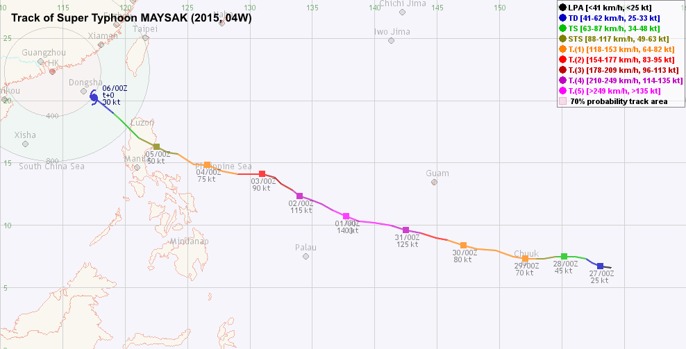
MAYSAK is the first category 5 super typhoon this year in the northwestern Pacific Basin, as well as the strongest cyclone in the first quarter on record.
The storm developed as a tropical wave to the east of Chuuk on March 26. The JTWC issued a tropical cyclone formation alert at 2 pm, and upgraded it into tropical depression 04W at 8 am the next day. 04W was then situated south of a broad subtropical ridge, and was expected to move W to WNW steadily across the Pacific Ocean.
04W's convections were initially segregated into northern and southern halves, but the storm consolidated gradually on March 27. The JMA upgraded it into a tropical storm at 2 am March 28, and named it MAYSAK. The name was contributed by Cambodia, and is a kind of tree. Within the next 24 hours, MAYSAK strengthened fairly quickly as it started to develop a central dense overcast with its peripheral convections tightened. Microwave imagery depicted a low-level eye early on March 29; both the JMA and the JTWC upgraded MAYSAK into typhoon status at 2 am that day; the JMA assessed it at 70 knots (130 km/h), higher than JTWC's 65 knots (120 km/h). MAYSAK crossed Chuuk in the morning, wiping out many structures and most areas were left without electricity after its passage.
MAYSAK turned WNW after crossing Chuuk and accelerated to around 20 km/h. It did not gain much strength in the remainder of that day. However, an eye became visible on infrared imagery on March 30. Later that day the storm entered a period of rapid intensification as the central dense overcast consolidated. Eyewall cloud top temperatures dropped to -80 degrees and the eye started to clear. The JTWC's estimated intensity was revised upwards from 95 knots (176 km/h) at 8 pm to 125 knots (232 km/h) at 2 am March 31. Photographs from the International Space Station on March 31 showed MAYSAK's symmetric eyewall and an eye that was essentially devoid of clouds.
As the eye continued to warm, the JTWC upgraded MAYSAK into a 140-knot (259 km/h) category 5 super typhoon at 2 pm. The JMA was at that time estimating MAYSAK's intensity at 100 knots (185 km/h), increased to a maximum of 115 knots (213 km/h) 6 hours later. With an estimated central sea level pressure of 905 hPa, MAYSAK becomes the strongest tropical cyclone in the first quarter on record for this basin, surpassing the next strongest storm by 25 hPa according to Digital Typhoon.
MAYSAK maintained such strength for the rest of the day, and in the early part of April 1 as it passed just 100 km north of Yap. The storm gained more latitude in the next two days; this placed the storm in a region of higher vertical wind shear and less ocean heat content. These unfavourable conditions caused MAYSAK to weaken quite substantially during the first few days in April. It was weakening by one category per day on average: at category 4 by the end of April 1, category 3 on April 2 and category 2 on April 3. Its eye became cloud-filled again, although still clearly visible on satellite images.
With little change in the steering environment, MAYSAK looked poised to cross Luzon and enter South China Sea in the next few days, which is rather rare at such an early time of the year. Models were generally in good agreement about this scenario, but dispersion was evident in their forecast track due to the variability of MAYSAK's intensity in the Sea. Official forecasts had MAYSAK just 300 km from Hong Kong, but nothing serious was expected as the storm would then be too weak to affect southern China.
MAYSAK weakened into a minimal typhoon on April 4. Without proper supply of energy from the ocean, the storm looked distorted as it neared Luzon. By the time it made landfall in the morning of April 5, it had already been downgraded into a tropical storm. MAYSAK's impact resulted in little damage there due to its weak strength. The storm moved NW during the day, and at one point it was very difficult to track the centre due to the destruction Luzon's mountain ranges had on the storm.
The HKO downgraded MAYSAK into a tropical depression at around 4 pm April 5, when MAYSAK was still crossing Luzon. As a strong northeasterly monsoon entered northern South China Sea, the sea temperatures were quite low there. MAYSAK finally weakened into an area of low pressure on April 6. Due to a weakening of the steering force, MAYSAK's remnants lingered at a distance of 300-400 km from Hong Kong and were eventually absorbed into the cold front that was passing that region.
美莎克是本年西北太平洋的首個五級超級颱風,亦是有紀錄以來該海域首季度最強的熱帶氣旋。
一股東風波於 3 月 26 日在楚克島以東海域形成,聯合颱風警報中心於下午 2 時對其發出熱帶氣旋形成警報,並於翌日早上 8 時將其升格為熱帶低氣壓 04W。當時 04W 處於副熱帶高壓脊南沿,預計大致向西或西北偏西移動,橫過太平洋。
初時 04W 南北半圓各自有其對流,但風暴於 27 日快速整合。日本氣象廳於 28 日凌晨 2 時將 04W 升格為熱帶風暴,並命名為美莎克。此名字由柬埔寨提供,是一種樹木的名稱。美莎克於接下來的 24 小時增強速度頗快,開始建立中心密集雲區,周邊環流亦變得較為緊密。29 日初段從微波雲圖可見低層風眼,日本氣象廳與聯合颱風警報中心均於凌晨 2 時將美莎克升格為颱風,而前者之估計風速達 70 節 (每小時 130 公里),高於後者的 65 節 (每小時 120 公里) 。美莎克於早上橫過楚克島,該地很多建築物受損,多處電力中斷。
美莎克通過楚克島後向西北偏西移動,並加速至約每小時 20 公里。它於當天沒甚增強,但其風眼於 30 日開始在紅外線雲圖可見。風暴於當天下半段快速增強,其中心密集雲區迅速整合,眼牆雲頂溫度下降至零下 80 度,風眼漸轉清晰。聯合颱風警報中心的強度估計由當晚 8 時的 95 節 (每小時 176 公里) 上調至 31 日凌晨 2 時的 125 節 (每小時 232 公里)。從國際太空站所拍攝的照片可清晰見到美莎克的眼牆十分對稱,風眼基本上無雲。
隨著美莎克的風眼進一步變暖,聯合颱風警報中心於 31 日下午 2 時將其升格至五級超級颱風強度 (140 節;每小時 259 公里)。當時日本氣象廳估計其中心強度為 100 節 (每小時 185 公里),於 6 小時後上調至最高 115 節 (每小時 213 公里),中心氣壓約為 905 百帕斯卡,令美莎克成為西北太平洋有紀錄以來首季最強的颱風,氣壓比次席低約 25 百帕斯卡 (Digital Typhoon 連結)。
美莎克於當天餘下時間維持該強度,並於 4 月 1 日在雅蒲島以北約 100 公里掠過。風暴於之後兩天緯度增加較快,令其處於垂直風切變較高而海溫較低的洋面。受不利環境因素影響,美莎克於 4 月首數天以每天約一級的強度穩步減弱。它於 1 日晚為一四級颱風,2 日減弱為三級,繼而於 3 日減弱為二級颱風。美莎克的風眼逐漸被雲層填塞,但仍於衛星雲圖上清晰可見。
由於駛流環境沒有大改變,各台預計美莎克將橫過呂宋並進入南海,這路徑於 4 月初是較為罕見的。雖然各數值模式均預料美莎克進入南海,但由於其強度較不確定,它們的預測路徑亦有分歧。官方氣象台預測美莎克將移至本港約 300 公里外,但由於屆時其強度已相當弱,對華南地區將不會有明顯影響。
美莎克於 4 日減弱至颱風強度下限。由於海洋上能量不足,風暴靠近呂宋前型態扭曲,缺乏組織,於 5 日早上登陸呂宋前已減弱為熱帶風暴。由於強度較低,美莎克橫過菲律賓時對該地造成的破壞有限。風暴向西北移動,受高山影響其中心曾有一段時間難以定位。
香港天文台於 5 日約下午 4 時將美莎克降格為熱帶低氣壓,當時美莎克仍然正在橫過呂宋。同時,一股較強勁的東北季候風進入南海,該處海溫較低,美莎克於惡劣大氣環境下終在 6 日減弱為低壓區。由於流場減弱,美莎克的殘餘於本港 300 至 400 公里外徘徊,最終被橫過該區的冷鋒吸收。
| Figures 圖片 |
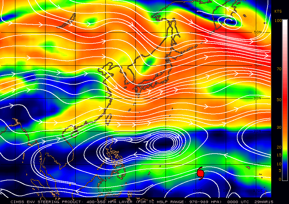
Figure 1 - Steering flow chart at 8 am March 29
圖 1 - 3 月 29 日上午 8 時之駛流圖
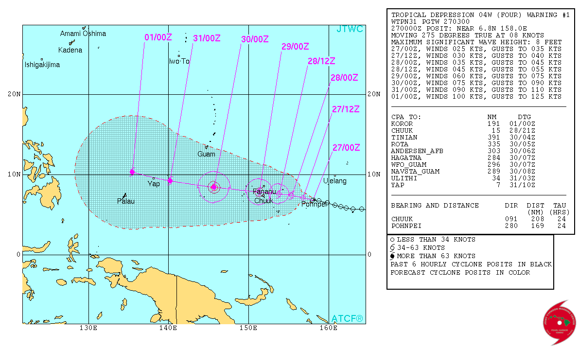
Figure 2 - Initial forecast track from the JTWC
圖 2 - 聯合颱風警報中心的首幅預測路徑圖

Figure 3 - MAYSAK making landfall at Chuuk
圖 3 - 美莎克登陸楚克島
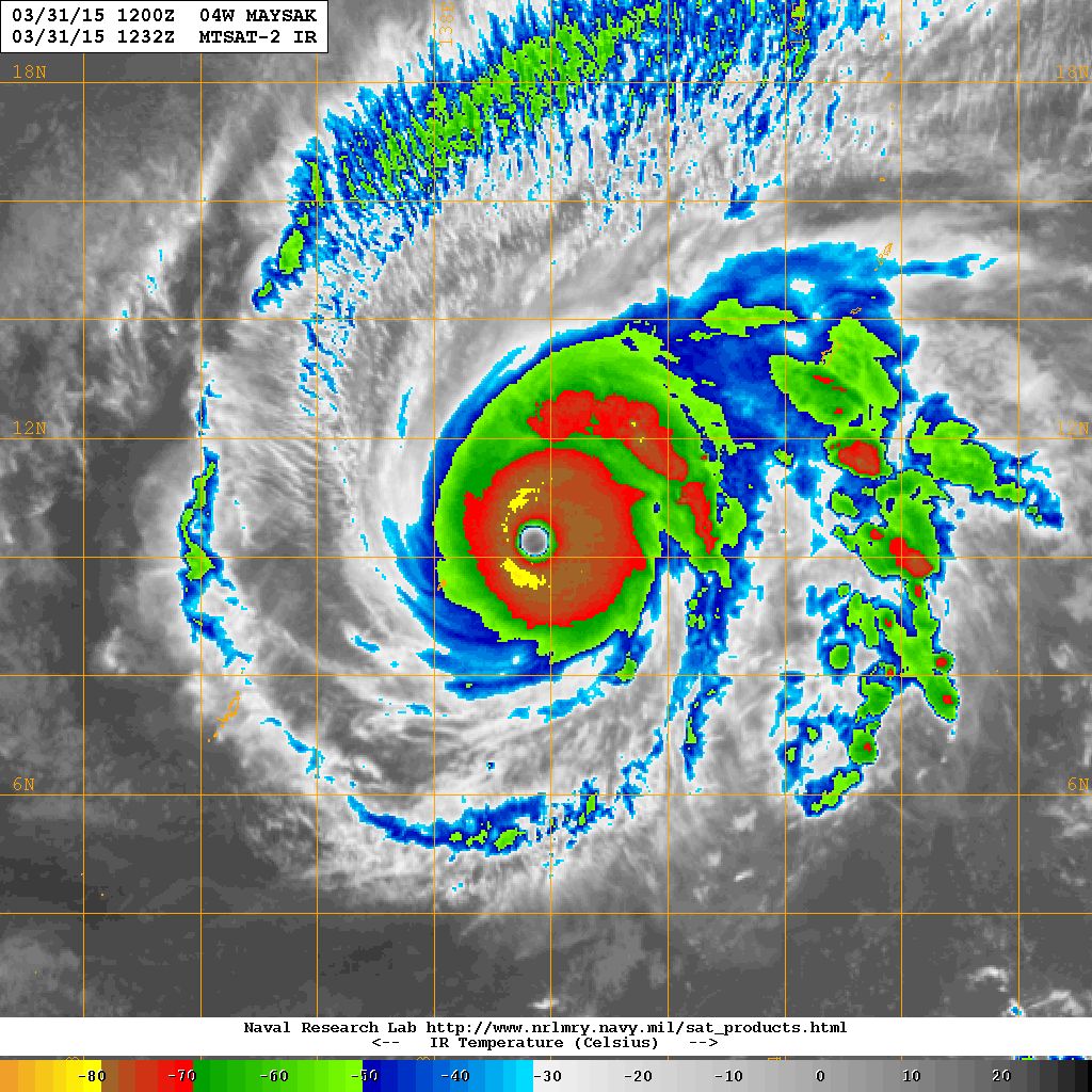
Figure 4 - MAYSAK reaching peak strength on March 31
圖 4 - 美莎克於 3 月 31 日達到巔峰強度

Figure 5 - MAYSAK's calculated wind field at 2 am April 1
圖 5 - 美莎克於 4 月 1 日凌晨 2 時之估算風場圖

Figure 6 - Photograph from the International Space Station showing MAYSAK's eye and circulation
圖 6 - 從國際太空站拍得的照片可見美莎克的風眼及環流


Figures 7a and 7b - Forecast tracks from different official agencies on March 31 (top) and April 4 (below)
圖 7a 及 7b - 各官方氣象機構於 3 月 31 日 (上) 及 4 月 4 日 (下) 之預測路徑圖
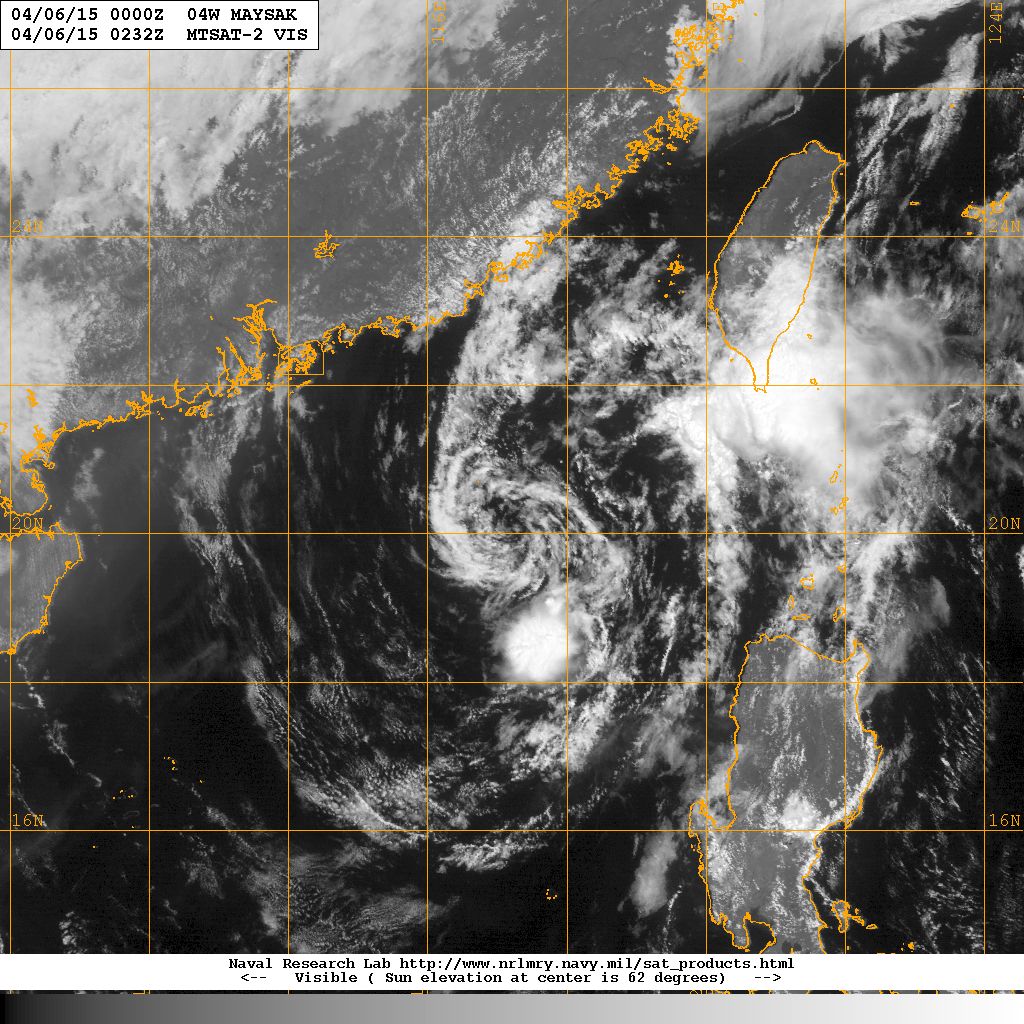
Figure 8 - MAYSAK disintegrating in northern South China Sea
圖 8 - 美莎克於南海北部消散中
| Other Data 其他數據 |
Table 1: Track data from HKWW:
表一 : 香港天氣觀測站之路徑資料
| YYMMDDZZ Lat Long Wind 15032618 066N1589E 020 15032700 067N1581E 025 15032706 070N1574E 030 15032712 073N1569E 035 15032718 075N1560E 040 15032800 075N1552E 045 15032806 075N1545E 050 15032812 073N1536E 060 15032818 073N1529E 070 15032900 073N1521E 070 15032906 075N1511E 075 15032912 080N1497E 080 15032918 081N1482E 080 15033000 084N1471E 080 15033006 088N1458E 085 15033012 090N1449E 095 15033018 094N1437E 115 15033100 096N1425E 125 15033106 100N1413E 140 15033112 102N1399E 140 15033118 103N1387E 140 15040100 107N1377E 140 15040106 112N1366E 130 15040112 117N1357E 125 15040118 121N1347E 120 15040200 123N1340E 115 15040206 128N1334E 110 15040212 133N1325E 105 15040218 138N1320E 100 15040300 141N1310E 090 15040306 141N1300E 085 15040312 141N1290E 080 15040318 143N1278E 080 15040400 148N1266E 075 15040406 149N1255E 065 15040412 157N1242E 060 15040418 158N1234E 055 15040500 163N1225E 050 15040506 170N1211E 040 15040512 184N1197E 035 15040518 190N1190E 030 15040600 202N1175E 030 |
Table 2: Track data from JTWC:
表二 : 聯合颱風警報中心之路徑資料
ID Name YYMMDD ZZZZ Lat Long Basin Wind Pres 04W MAYSAK 150406 1800 20.0N 117.5E WPAC 15 1010 |
Last Accessed 最近訪問日期: Thu Apr 18 2024 14:54:52 HKT
Last Modified 最近修訂日期: Mon Jul 24 2023
