
TC Watch / 熱帶氣旋 > Selected TC Review / 重要熱帶氣旋回顧 > 201508W (KUJIRA 鯨魚) [Refresh 更新]
 201508W (KUJIRA 鯨魚) - Profile 檔案 201508W (KUJIRA 鯨魚) - Profile 檔案 |
(First draft Issued on June 27, 2015; final version issued on July 12, 2015)
(初稿於 2015 年 6 月 27 日發出,最後版本於 2015 年 7 月 12 日上載)
Brief profile of KUJIRA 鯨魚小檔案:
| JTWC number 聯合颱風警報中心 (JTWC) 號碼 | 08W |
| International number 國際編號 | 1508 |
| Period of existence 生存時期 (JTWC) | 2015/06/20 20 HKT - 2015/06/24 14 HKT |
| Lifetime 壽命 (JTWC) | 3.75 days 日 |
| Maximum 1-minute wind (JTWC) JTWC 一分鐘平均最高中心風速 | 45 knots 節 (Tropical Storm 熱帶風暴) |
| Minimum pressure (JTWC) JTWC 最低氣壓 | 989 hPa 百帕 |
| Highest TC signal by HKO (if applicable) 香港天文台發出最高熱帶氣旋警告信號 |
1 (Standby Signal 戒備信號) |
| Closest point of approach by HKO (if applicable) 香港天文台所示之最接近距離 (如適用) |
SW 510 km (real-time warning 實時報告 / TC report 熱帶氣旋報告) |
| Time of closest approach by HKO (if applicable) 香港天文台所示之最接近時間 (如適用) |
Around 約 2015/06/22 18 HKT (real-time warning 實時報告) / 16 HKT (TC report 熱帶氣旋報告) |
| Lowest pressure recorded at HKO (if applicable) 香港天文台錄得的最低氣壓 (如適用) |
1001.7 hPa 百帕 (2015/06/22 16:04 HKT) |
TC signals for Hong Kong & Track 香港曾經生效的熱帶氣旋警告和路徑圖:
Table 表:
| Signal 信號 |
Date and time 日期和時間 |
Distance from HK 與香港的距離 |
Predicted movement 預測移動方向和速度 |
Max. 10-min winds 中心最高十分鐘平均風速 |
 |
2015/06/21 (SUN) 21:40 HKT | SSW 660 km | N at 12 km/h | 65 km/h (35 knots, TS) |
 |
2015/06/23 (TUE) 07:40 HKT | WSW 560 km | NW at 12 km/h | 65 km/h (35 knots, TS) |
Figure 圖:
(Track courtesy of Lorenzo. Data from HKO. 鳴謝 Lorenzo 提供路徑圖,資料取自天文台)
IR imagery animation 紅外線雲圖動畫:
TC track from HKWW 本站的熱帶氣旋路徑圖:

TC track from HKO 天文台的熱帶氣旋路徑圖:

| Past HKWW Bulletins on KUJIRA 本站有關鯨魚的發佈 |
Please click here for bulletins on KUJIRA. 請按這裡。
| Storm Formation and Development 氣旋形成和發展 |
Unless otherwise stated, all times below are in Hong Kong Standard Time (UTC+8)
除非特別註明,下文時間均為香港標準時間 (協調世界時加 8 小時)
After almost a month of inactivity, the intertropical convergence zone in northwestern Pacific became active again in the middle of June. An area of low pressure persisted in central South China Sea on June 18. Convections developed around its periphery on June 19; the JTWC issued a tropical cyclone formation alert at 8 am June 20. The wind field scan that morning depicted a clear low-level circulation centre south of Xisha, with strongest winds in its southwestern quadrant.
The JTWC upgraded that disturbance into tropical depression 08W at 8 pm that night. Under the influence of the subtropical ridge in southeastern China, 08W had been moving northwest slowly along the southwestern periphery of the ridge. Numerical models were generally predicting 08W to stagnate and then move north or north-northeast, as the ridge was expected to retreat ahead of a propagating mid-latitude trough. JTWC's initial bulletin adopted this philosophy, predicting 08W to intensify into a tropical storm and pass just east of Hainan Island. Meanwhile, the JMA issued a gale warning at 2 pm June 20, while the HKO upgraded 08W into a tropical depression at 10 pm that night.
08W's convections tightened during the night of June 20 and early June 21. However, vertical wind shear strengthened to around 30 knots (56 km/h), causing the newly-developed convections to displace to the storm's southwestern quadrant. Nevertheless, clouds started to form north of 08W, a clear indication that the subtropical ridge was retreating.
The JMA upgraded 08W into a tropical storm at 8 am June 21 and named it KUJIRA. As expected, the storm decelerated and started to move north that afternoon. From radar images at Xisha, KUJIRA appeared to move north-northeast at times.
經過接近一個月的平靜期,西北太平洋的熱帶輻合帶於 6 月中旬轉趨活躍。一個低壓區於 18 日在南海中部醞釀,19 日對流沿其周邊發展,聯合颱風警報中心於 20 日早上 8 時對其發出熱帶氣旋形成警報。當天早上的風場掃描顯示西沙以南有一清晰低層環流中心,最強風速於其西南象限。
聯合颱風警報中心於當晚 8 時將該擾動升格為熱帶低氣壓 08W。受盤據於中國東南部的副熱帶高壓脊影響,08W 此前沿該脊西南部向西北緩慢移動。數值模式大多預測副高將受西風槽侵擊而東退,令 08W 滯留,後向北或東北偏北移動。聯合颱風警報中心的初始發布採取此情境,預測 08W 將增強為熱帶風暴,並於海南島以東近距離掠過。另一方面,日本氣象廳於 20 日下午 2 時發出烈風警報,而香港天文台則於當晚 10 時將 08W 升格為熱帶低氣壓。
08W 的對流於 20 日晚間及 21 日初時收緊,但同時該區的垂直風切變增強至約 30 節 (每小時 56 公里),令新形成的對流被切離至風暴的西南象限。雖然如此,風暴北面亦漸見雲帶,顯示副高正東退。
日本氣象廳於 21 日早上 8 時將 08W 升格為熱帶風暴,並命名為鯨魚。一如所料,鯨魚當天下午減速並開始北移。由西沙的雷達圖所見,鯨魚間中向東北偏北移動。

Figure 1 - Wind field of KUJIRA at its formation
圖 1 - 鯨魚初形成時之風場圖

Figure 2 - Satellite image of KUJIRA at its formation
圖 2 - 鯨魚初形成時之衛星雲圖


Figures 3a and 3b - Forecast tracks from different agencies on June 21 (left) and June 23 (right)
圖 3a 及 3b - 各氣象台於 6 月 21 (左) 及 23 日 (右) 之預測路徑圖
| Approaching Southern China and Northern Vietnam 靠近華南及越南北部 |
Locally, it was very hot on June 20 as the subtropical ridge had been covering southern China for several days. The maximum air temperature of 34.1 degrees measured at the Observatory that afternoon was the highest for the Dragon Boat Festival on record. As the ridge weakened, squally showers started to affect the territory on June 21. Due to the approach of KUJIRA, the HKO issued the #1 Standby Signal at 9:40 pm, when the storm was 660 km south-southwest of Hong Kong.
KUJIRA maintained a northerly course during the night of June 21. It was closest to Xisha at around 8 pm, passing west of the archipelago. Despite the formation of convective bursts near the storm's centre, KUJIRA's upper-level convections were rather disorganized. However, the wind field scan at around 9:30 pm showed that the storm was packing winds of up to 45 knots (83 km/h) near its centre. The HKO upgraded KUJIRA into a tropical storm at 10 pm, while the CMA, using 2-minute average wind speeds, upgraded it into a severe tropical storm at 11 pm. Perhaps because of its poor cloud banding, the JTWC's assessment remained at tropical depression category, upgrading only as late as in the afternoon of June 22. It later revised KUJIRA's past intensity though.
KUJIRA moved north-northwest steadily after midnight June 22. Some agencies shifted their forecast tracks to the west as such motion commenced earlier than they expected. Instead of skirting eastern Hainan, the new forecasts called for a landfall at eastern Hainan, followed by a second landfall at southern Leizhou Peninsula. However the storm moved increasingly equatorward during the day. According to Chinese authorities, KUJIRA made landfall near Wanning, Hainan near 6:50 pm June 22. It crossed central Hainan during the night without losing much intensity, as new convective bursts continued to form in its southwestern quadrant. Squally showers continued to affect Hong Kong on June 22; strong winds were observed occasionally offshore.
As KUJIRA was moving northwest, it no longer posed a wind threat to Hong Kong. The Observatory cancelled the #1 Standby Signal at 7:40 am June 23. KUJIRA was situated about 560 km west-southwest of Hong Kong at that time. KUJIRA left Hainan and entered the Gulf of Tonkin in the morning of June 23. It crossed the Gulf in a west-northwesterly direction and was moving almost due west at times; none of the official agencies was able to predict such occurrence.
KUJIRA reached northern Vietnam coast in the morning of June 24. Its centre drifted northwest as it made landfall, later nearing Hanoi in close proximity. The HKO downgraded KUJIRA into a tropical depression at 9 pm. The storm decelerated inland and further weakened into an area of low pressure in the morning of June 25.
本港方面,由於副高盤據華南已達數天之久,20 日天氣酷熱。天文台於當天錄得最高氣溫 34.1 度,是有紀錄以來最熱的端午節。隨著副高減弱,本港於 21 日開始受狂風驟雨影響。由於鯨魚逐步靠近,天文台於當晚 9 時 40 分發出一號戒備信號,當時風暴於香港西南偏南約 660 公里。
鯨魚於 21 日晚間維持偏北路徑,並於晚上 8 時左右最接近西沙島,於該島以西掠過。風暴中心有對流爆發,但鯨魚的高層對流仍較為鬆散。雖然如此,於下午約 9 時 30 分的風場掃描指出風暴近中心風力達 45 節 (每小時 83 公里)。天文台於晚上 10 時將鯨魚升格為熱帶風暴,而使用兩分鐘平均風速的中國氣象局則於晚上 11 時將其升格為強烈熱帶風暴。或許是由於風暴旋捲度欠佳,聯合颱風警報中心維持其熱帶低氣壓的強度估計,遲至 22 日下午才將風暴升格為熱帶風暴。該中心其後修訂風暴的過去強度。
鯨魚於 22 日午夜過後穩定向西北偏北移動。由於此移向較部分氣象台原先預計早出現,它們把預測路徑西調,由以海南東面海域掠過修訂為於海南東部登陸,並於雷州半島南部再次登陸。可是,風暴的移向於日間進一步西偏。根據中國當局,鯨魚於 22 日下午約 6 時 50 分登陸海南萬寧。風暴於當晚橫過海南中部,期間繼續有對流爆發,其強度未受明顯影響。本港於 22 日繼續有狂風驟雨,離岸間中吹強風。
由於鯨魚持續向西北移動,它對香港的風力威脅大致解除。天文台於 23 日早上 7 時 40 分取消一號戒備信號,當時鯨魚位於香港西南偏西約 560 公里處。鯨魚於 23 日早上離開海南島,並進入北部灣。它採取西北偏西路徑橫過北部灣,間中更近乎西移,這是所有氣象台先前皆未能預測到的。
鯨魚於 24 日早上到達越南北部沿岸,其中心於登陸後向西北飄移,其後近距離掠過河內,天文台於晚上 9 時將其降格為熱帶低氣壓。風暴於內陸減速,並繼續減弱,最終於 25 日早上減弱為低壓區。

Figure 4 - Squally showers affecting Hong Kong in the afternoon of June 21
圖 4 - 本港於 6 月 21 日下午受狂風驟雨影響

Figure 5 - Radar image of KUJIRA as it neared Xisha
圖 5 - 鯨魚掠過西沙時之雷達圖
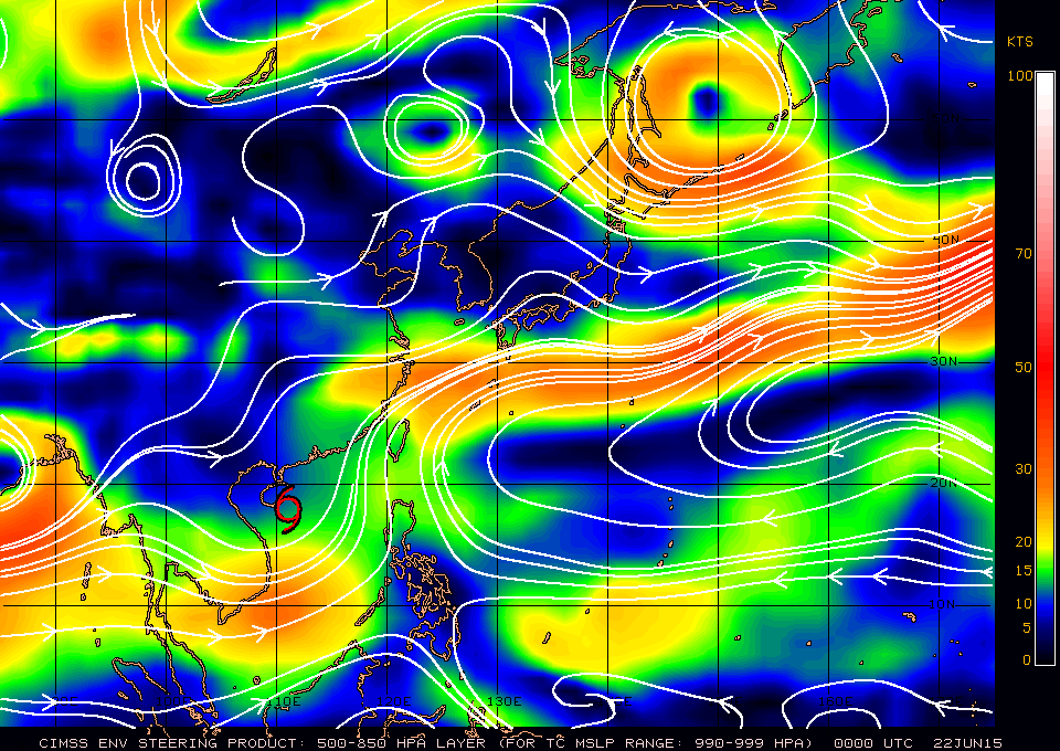
Figure 6 - Steering flow chart at 8 am June 22
圖 6 - 6 月 22 日上午 8 時的駛流圖

Figure 7 - Wind field analysis of KUJIRA just before its landfall at Hainan
圖 7 - 鯨魚登陸海南島前之風場分析
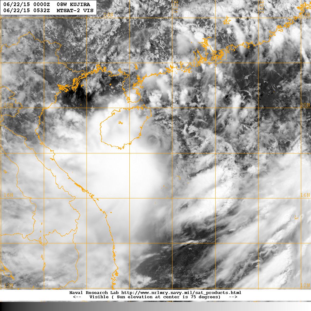
Figure 8 - Satellite image of KUJIRA at maximum intensity
圖 8 - 鯨魚到達巔峰強度時之衛星雲圖
| Winds Recorded at Reference Stations 參考站所錄得的風速 |
(Except for special cases, this section is not available for cyclones that only necessitated the Standby Signal 除非特別情況,否則此部只當氣旋令天文台發出三號或更高信號時提供)
| Charts and Figures 各項數據 |
Table 1: Track data from HKWW (times are in UTC)
表一 : 香港天氣觀測站之路徑資料 (時間為世界協調時)
YYMMDDZZ Lat Long Wind |
Table 2: Maximum gust and hourly average wind speed recorded in Hong Kong from HKO:
表二 : 香港天文台公佈的各站最高每小時平均風力和陣風數據
| Station | Maximum Gust |
Maximum Hourly Mean Wind |
||||||
|---|---|---|---|---|---|---|---|---|
| Direction |
Speed (km/h) |
Date/Month |
Time |
Direction |
Speed (km/h) |
Date/Month |
Time |
|
| Bluff Head (Stanley) | SE |
56 |
21/6 |
23:57 |
SE |
31 |
23/6 |
02:00 |
| Central Pier | E |
38 |
22/6 |
22:03 |
E |
23 |
22/6 |
22:00 |
| Cheung Chau | ESE |
67 |
23/6 |
1:57 |
SE |
43 |
23/6 |
03:00 |
| Cheung Chau Beach | E |
65 |
23/6 |
1:49 |
E |
36 |
23/6 |
02:00 |
| Green Island | ESE |
56 |
23/6 |
2:00 |
NE |
30 |
21/6 |
22:00 |
| Hong Kong International Airport | ESE |
52 |
23/6 |
2:08 |
ESE |
30 |
23/6 |
03:00 |
ESE |
52 |
23/6 |
2:09 |
|||||
| Kai Tak | ESE |
47 |
23/6 |
1:49 |
ESE |
23 |
23/6 |
02:00 |
ESE |
47 |
23/6 |
1:50 |
|||||
| King's Park | ESE |
41 |
22/6 |
23:23 |
ESE |
16 |
23/6 |
00:00 |
| Lau Fau Shan | SSE |
51 |
22/6 |
16:51 |
SSE |
20 |
22/6 |
17:00 |
| Ngong Ping | E |
90 |
23/6 |
0:48 |
E |
56 |
22/6 |
23:00 |
| North Point | E |
36 |
22/6 |
18:53 |
E |
19 |
22/6 |
22:00 |
E |
19 |
22/6 |
23:00 |
|||||
| Peng Chau | E |
58 |
22/6 |
0:26 |
E |
27 |
21/6 |
23:00 |
| Ping Chau | SE |
34 |
23/6 |
2:57 |
E |
7 |
22/6 |
01:00 |
| Sai Kung | SSE |
58 |
23/6 |
1:40 |
SSE |
23 |
23/6 |
02:00 |
| Sha Chau | S |
56 |
22/6 |
15:31 |
SE |
34 |
23/6 |
03:00 |
| Sha Lo Wan | E |
51 |
23/6 |
2:11 |
ESE |
22 |
23/6 |
01:00 |
| Sha Tin | SE |
36 |
22/6 |
12:08 |
SE |
14 |
22/6 |
15:00 |
| Star Ferry (Kowloon) | E |
54 |
23/6 |
1:31 |
E |
25 |
23/6 |
02:00 |
| Ta Kwu Ling | E |
31 |
23/6 |
0:07 |
E |
12 |
23/6 |
01:00 |
| Tai Mei Tuk | ENE |
45 |
22/6 |
1:45 |
ENE |
25 |
22/6 |
01:00 |
E |
25 |
23/6 |
00:00 |
|||||
| Tai Po Kau | SE |
38 |
23/6 |
1:59 |
E |
22 |
23/6 |
00:00 |
| Tap Mun | SE |
49 |
23/6 |
3:03 |
SE |
22 |
23/6 |
04:00 |
| Tate's Cairn | SSE |
67 |
21/6 |
21:46 |
ESE |
34 |
23/6 |
00:00 |
| Tseung Kwan O | E |
40 |
23/6 |
1:37 |
ESE |
12 |
22/6 |
15:00 |
| Tsing Yi Shell Oil Depot | SSE |
40 |
22/6 |
16:26 |
SE |
19 |
22/6 |
12:00 |
| Tuen Mun Government Offices | SSE |
43 |
22/6 |
15:39 |
SSE |
14 |
22/6 |
16:00 |
SSE |
43 |
22/6 |
15:40 |
|||||
SSE |
43 |
22/6 |
16:35 |
|||||
| Waglan Island | SE |
67 |
23/6 |
1:04 |
SSE |
38 |
23/6 |
02:00 |
| Wetland Park | S |
31 |
22/6 |
16:50 |
S |
13 |
22/6 |
17:00 |
| Wong Chuk Hang | SE |
58 |
22/6 |
0:07 |
E |
16 |
22/6 |
23:00 |
E |
58 |
22/6 |
11:12 |
|||||
Table 3: Rainfall (in millimetres) contributed by KUJIRA from HKO (figures in brackets are based on incomplete hourly data):
表三 : 香港天文台公佈的各站雨量資料 (方括號內之數據由不完整之每小時資料擷取)
| Station | 21-Jun |
22-Jun |
23-Jun |
Total Rainfall (mm) |
|
|---|---|---|---|---|---|
| Hong Kong Observatory | 39.9 |
18.1 |
51.3 |
109.3 |
|
| Hong Kong International Airport (HKA) | 19.8 |
52.7 |
18.7 |
91.2 |
|
| Cheung Chau (CCH) | 56.5 |
11.5 |
25.5 |
93.5 |
|
| H23 | Aberdeen | 35.5 |
37.5 |
56.5 |
129.5 |
| N05 | Fanling | 30.5 |
7.0 |
37.0 |
74.5 |
| N13 | High Island | 52.0 |
4.0 |
22.5 |
78.5 |
| K04 | Jordan Valley | 74.5 |
20.5 |
73.5 |
168.5 |
| N06 | Kwai Chung | 60.5 |
28.0 |
55.5 |
144.0 |
| H12 | Mid Levels | 59.5 |
31.5 |
59.5 |
150.5 |
| N09 | Sha Tin | 50.0 |
8.5 |
65.0 |
123.5 |
| H19 | Shau Kei Wan | 67.0 |
13.5 |
89.0 |
169.5 |
| SEK | Shek Kong | 37.5 |
29.0 |
35.0 |
101.5 |
| K06 | So Uk Estate | 55.0 |
28.0 |
57.0 |
140.0 |
| R31 | Tai Mei Tuk | 20.0 |
7.5 |
51.0 |
78.5 |
| R21 | Tap Shek Kok | 25.5 |
17.5 |
22.5 |
65.5 |
| N17 | Tung Chung | 30.5 |
43.5 |
34.0 |
108.0 |
| R27 | Yuen Long | 24.5 |
16.0 |
29.0 |
69.5 |
Last Accessed 最近訪問日期: Sat Apr 20 2024 01:12:45 HKT
Last Modified 最近修訂日期: Mon Jul 24 2023
