
TC Watch / 熱帶氣旋 > Selected TC Review / 重要熱帶氣旋回顧 > 201605W (MIRINAE 銀河) [Refresh 更新]
 201605W (MIRINAE 銀河) - Profile 檔案 201605W (MIRINAE 銀河) - Profile 檔案 |
(First draft issued on August 7, 2016; final version issued on August 14, 2016)
(初稿於 2016 年 8 月 7 日發出,最後版本於 2016 年 8 月 14 日上載)
Brief profile of MIRINAE | 銀河小檔案:
| JTWC number 聯合颱風警報中心 (JTWC) 號碼 | 05W |
| International number 國際編號 | 1603 |
| Period of existence 生存時期 (JTWC) | 2016/07/25 20 HKT - 2016/07/29 02 HKT |
| Lifetime 壽命 (JTWC) | 3.25 days 日 |
| Maximum 1-minute wind (JTWC) JTWC 一分鐘平均最高中心風速 | 50 knots 節 (Severe Tropical Storm 強烈熱帶風暴) |
| Minimum pressure (JTWC) JTWC 最低氣壓 | 985 hPa 百帕 |
| Highest TC signal by HKO (if applicable) 香港天文台發出最高熱帶氣旋警告信號 |
1 (Standby Signal 戒備信號) |
| Closest point of approach by HKO (if applicable) 香港天文台所示之最接近距離 (如適用) |
SSW 490 km (real-time warning 實時報告) / SW 490 km (TC report 熱帶氣旋報告) |
| Time of closest approach by HKO (if applicable) 香港天文台所示之最接近時間 (如適用) |
Around 約 2016/07/26 12 HKT (real-time warning 實時報告) / 14 HKT (TC report 熱帶氣旋報告) |
| Lowest pressure recorded at HKO (if applicable) 香港天文台錄得的最低氣壓 (如適用) |
1006.6 hPa 百帕 (2016/07/26 16:12 HKT) |
TC signals for Hong Kong & Track 香港曾經生效的熱帶氣旋警告和路徑圖:
Table 表:
| Signal 信號 |
Date and time 日期和時間 |
Distance from HK 與香港的距離 |
Predicted movement 預測移動方向和速度 |
Max. 10-min winds 中心最高十分鐘平均風速 |
 |
2016/07/26 (TUE) 08:40 HKT | SSW 500 km | WNW at 20 km/h | 55 km/h (30 knots, TD) |
 |
2016/07/26 (TUE) 23:20 HKT | SW 550 km | WNW at 20 km/h | 75 km/h (40 knots, TS) |
Figure 圖:
(Track figure courtesy of Lorenzo. Data from HKO. 鳴謝 Lorenzo 提供路徑圖,資料取自天文台)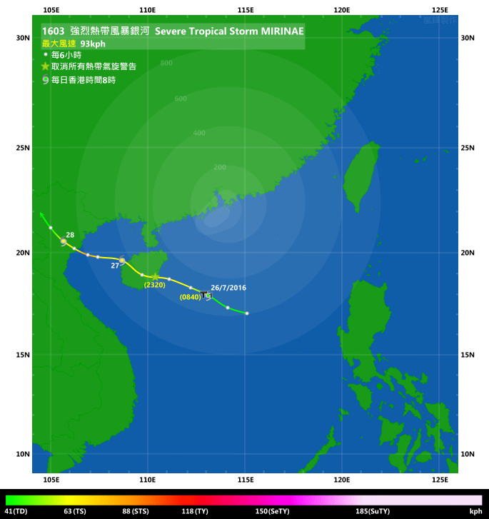
IR imagery animation 紅外線雲圖動畫:
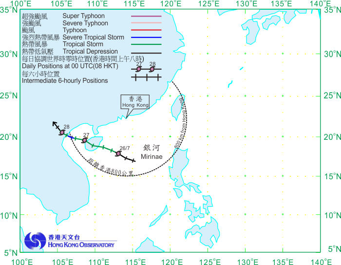
TC track from HKWW 本站的熱帶氣旋路徑圖:

TC track from HKO 天文台的熱帶氣旋路徑圖:
| Past HKWW Bulletins on MIRINAE 本站有關銀河的發佈 |
Please click here for bulletins on MIRINAE. 請按這裡。
| Storm Formation and Development 氣旋形成和發展 |
Unless otherwise stated, all times below are in Hong Kong Standard Time (UTC+8)
除非特別註明,下文時間均為香港標準時間 (協調世界時加 8 小時)
MIRINAE developed from a patch of convective cloud bands that had persisted near Luzon since July 23. Various numerical models picked up the system at that time and predicted possible tropical cyclogenesis early next week within the South China Sea. Easterlies were prevailing in the region, and the patch of cloud bands moved west into the South China Sea the next day. Convections continued to gather and showed spiraling characteristics on July 25, leading the JTWC to issue a tropical cyclone formation alert on the then-disturbance 95W that afternoon.
95W developed further that evening; the JTWC upgraded the system into tropical depression 05W in its 8 pm bulletin on July 25. The HK Observatory also upgraded 95W into a tropical depression that night. 05W was situated around 600 km south of Hong Kong and was still moving west with moderate speed, losing roughly half a degree of longitude every 3 hours. The subtropical ridge northwest of 05W was expected to weaken slightly and initial forecasts had the storm turning more poleward, i.e., moving WNW, in the general direction of Hainan Island. Upon formation, the HKO indicated that the storm would maintain a distance of over 400 km from Hong Kong the next day, and that it would consider the issuance of the Standby Signal on July 26.
發展成銀河的雲團最初於 7 月 23 日在呂宋一帶形成,當時部分數值預報模式預測南海下周或有熱帶氣旋活動。由於該區受東風主導,該雲團於翌日進入南海,並於 25 日進一步積聚發展,並呈現螺旋形態。聯合颱風警報中心於當天下午對該擾動 (95W) 發出熱帶氣旋形成警報。
95W 於 25 日晚繼續發展,聯合颱風警報中心遂於當晚 8 時將其升格為熱帶低氣壓 05W,而香港天文台亦於當晚作出升格。升格之時 05W 位處香港以南約 600 公里處,並穩定向偏西移動,約每 3 小時西移半個經度。由於預料 05W 西北方的副熱帶高壓脊將稍為減弱,初始預報顯示風暴的移向將漸轉西北偏西,大致趨向海南島。香港天文台表示該風暴將於翌日與本港保持超過 400 公里距離,會於 26 日考慮發出戒備信號。

Figure 1 - Satellite image of 95W before developing into a tropical depression
圖 1 - 95W 發展為熱帶低氣壓前之衛星雲圖
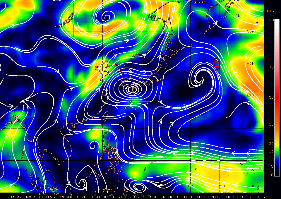
Figure 2 - Steering flow chart in the morning of July 25
圖 2 - 7 月 25 日早上的駛流圖
| Landfall at Hainan and Subsequent Development 登陸海南及其後發展 |
05W picked up some latitude overnight and came to around 500 km from Hong Kong in the morning of July 26. The storm is in an environment of moderate vertical wind shear and most convections were displaced to the west. The HKO issued the #1 Standby Signal at 8:40 am and mentioned that higher signals were not likely during the rest of the day, while there could be squally showers and thunderstorms. 05W's low-level circulation centre became partially exposed in the morning, but was quickly filled again by expanding convections; the storm was in general strengthening during the morning. The HKO upgraded 05W into a tropical storm in its 2 pm tropical cyclone bulletin, while the JMA made the upgrade just an hour later, naming the cyclone MIRINAE.
MIRINAE maintained a distance of around 490 to 500 km from Hong Kong in the afternoon. Winds were generally quite weak in the territory, but there were some showers due to MIRINAE's outer cloud bands. Only Ngong Ping recorded strong winds for a brief moment near noon.
As MIRINAE continued to travel west, the HKO indicated that the Standby Signal would be cancelled when MIRINAE was no longer a threat to the territory. It made landfall near Wanning, Hainan just after 10 pm July 26. It is worth noting that the NMC of China upgraded MIRINAE further into a severe tropical storm prior to landfall, with estimated winds of 30 m/s (108 km/h). The Standby Signal was eventually cancelled at 11:20 pm when the storm was around 550 km southwest of Hong Kong.
MIRINAE travelled across central Hainan that night and entered the Gulf of Tonkin in the early morning of July 27, still moving WNW. Due to land interaction, MIRINAE weakened slightly when it crossed the island and convections in its northern semicircle diminished. However MIRINAE continued to receive moisture from the south and, as the storm entered the very warm Gulf with sea surface temperatures over 30 degrees, it quickly picked up strength and a formative eye could be seen that night. As such, both the JMA and NMC upgraded MIRINAE into a severe tropical storm at 8 pm*. This however did not last long, as MIRINAE made landfall shortly after midnight July 28.
MIRINAE turned northwest after landfall and skirted past within several dozen kilometres from Hanoi during the day. It degenerated gradually and the HKO downgraded the system into an area of low pressure at 10 pm July 28.
* The HKO upgraded MIRINAE into a severe tropical storm in its TC report afterwards.
05W 於凌晨略為北移,至 26 日早上距離香港約 500 公里。由於 05W 所處一帶垂直風切變不低,其對流整體向西切離。香港天文台於早上 8 時 40 分發出一號戒備信號,並表示香港會有幾陣狂風驟雨及雷暴,但當日需要改發更高信號的機會不大。早上,05W 的低層環流中心部分外露,但很快便被發展中的對流填補,風暴日間大致呈增強之勢。香港天文台於其下午 2 時的熱帶氣旋警報中將 05W 升格為熱帶風暴,而日本氣象廳於一小時後亦跟隨,並將其命名為銀河。
銀河於 26 日下午與香港保持 490 至 500 公里距離。本地整體風勢較弱,只有昂坪於近中午時份曾短暫錄得強風,但因銀河的外圍雲帶影響而有驟雨。
隨著銀河繼續西移,香港天文台表示當風暴不再對本港構成威脅,將考慮取消戒備信號。銀河於 26 日晚 10 時過後登陸海南萬寧,值得留意的是中國方面於風暴登陸前曾將其升格為強烈熱帶風暴,並估計中心風速達每秒 30 米 (每小時 108 公里)。香港天文台於晚上 11 時 20 分取消一號戒備信號,當時風暴位於香港西南約 550 公里處。
銀河當晚橫過海南中部,並於 27 日早上進入北部灣,繼續向西北偏西移動。受陸地影響,銀河於橫過海南時略為減弱,其北半圓的對流減少。但由於銀河繼續從南面獲得濕潤空氣,且北部灣海面非常溫暖 (達 30 度),它於該區再度增強,當晚更發展出風眼雛型。日本氣象廳及中國中央氣象台均於當晚 8 時將風暴升格為強烈熱帶風暴*。升格後不久,銀河於 28 日午夜過後即登陸越南北部。
銀河登陸後向西北移動,日間於河內數十公里範圍內掠過。它在陸上逐漸減弱,香港天文台於 28 日晚上 10 時將其降格為低壓區。
* 香港天文台於其事後熱帶氣旋報告中將銀河升格為強烈熱帶風暴。

Figure 3 - Forecast tracks from various official agencies in the afternoon of July 26
圖 3 - 7 月 26 日各官方氣象台之預測路徑

Figure 4 - Wind field analysis in the morning of July 27
圖 4 - 7 月 27 日早上之風場掃描圖

Figure 5 - Various satellite images of MIRINAE just after landfall at northern Vietnam
圖 5 - 銀河登陸越南北部時之衛星影像
| Winds Recorded at Reference Stations 參考站所錄得的風速 |
(Except for special cases, this section is not available for cyclones that only necessitated the Standby Signal 除非特別情況,否則此部只當氣旋令天文台發出三號或更高信號時提供)
| Charts and Figures 各項數據 |
Table 1: Track data from HKWW:
表一 : 香港天氣觀測站之路徑資料
YYMMDDZZ Lat Long Wind |
Table 2: Maximum gust and hourly average wind speed recorded in Hong Kong from HKO:
表二 : 香港天文台公佈的各站最高每小時平均風力和陣風數據 (英文)
| Station | Maximum Gust |
Maximum Hourly Mean Wind |
||||||
|---|---|---|---|---|---|---|---|---|
Direction |
Speed (km/h) |
Date/Month |
Time |
Direction |
Speed (km/h) |
Date/Month |
Time |
|
| Bluff Head (Stanley) | ENE |
31 |
26/7 |
12:18 |
ENE |
16 |
26/7 |
22:00 |
| Central Pier | E |
40 |
26/7 |
14:35 |
E |
20 |
26/7 |
17:00 |
| Cheung Chau | SE |
45 |
26/7 |
14:17 |
ESE |
23 |
26/7 |
15:00 |
| Cheung Chau Beach | E |
41 |
26/7 |
14:19 |
E |
23 |
26/7 |
14:00 |
| Green Island | NE |
45 |
26/7 |
14:41 |
NE |
30 |
26/7 |
15:00 |
| Hong Kong International Airport | SE |
41 |
26/7 |
15:07 |
ESE |
25 |
26/7 |
15:00 |
ESE |
25 |
26/7 |
16:00 |
|||||
| Kai Tak | E |
41 |
26/7 |
12:19 |
ESE |
16 |
26/7 |
13:00 |
| King's Park | SSE |
30 |
26/7 |
15:37 |
SE |
12 |
26/7 |
11:00 |
SSE |
12 |
26/7 |
17:00 |
|||||
SE |
12 |
26/7 |
19:00 |
|||||
| Lau Fau Shan | SSE |
65 |
26/7 |
13:25 |
SE |
19 |
26/7 |
16:00 |
| Ngong Ping | E |
62 |
26/7 |
10:03 |
E |
38 |
26/7 |
10:00 |
E |
38 |
26/7 |
12:00 |
|||||
| North Point | E |
43 |
26/7 |
12:22 |
E |
20 |
26/7 |
17:00 |
| Peng Chau | E |
38 |
26/7 |
12:53 |
E |
22 |
26/7 |
11:00 |
| Ping Chau | SE |
20 |
26/7 |
15:03 |
E |
4 |
26/7 |
11:00 |
| Sai Kung | SE |
31 |
26/7 |
12:28 |
E |
14 |
26/7 |
16:00 |
| Sha Chau | SSE |
36 |
26/7 |
17:02 |
SSE |
23 |
26/7 |
18:00 |
| Sha Lo Wan | ESE |
41 |
26/7 |
15:06 |
ESE |
16 |
26/7 |
16:00 |
| Sha Tin | ESE |
27 |
26/7 |
14:53 |
SE |
9 |
26/7 |
15:00 |
SSE |
9 |
26/7 |
17:00 |
|||||
| Shek Kong | ENE |
31 |
26/7 |
11:59 |
E |
14 |
26/7 |
16:00 |
| Star Ferry (Kowloon) | E |
41 |
26/7 |
12:26 |
E |
16 |
26/7 |
14:00 |
E |
16 |
26/7 |
15:00 |
|||||
| Ta Kwu Ling | NE |
31 |
26/7 |
12:23 |
ENE |
13 |
26/7 |
13:00 |
E |
13 |
26/7 |
16:00 |
|||||
| Tai Mei Tuk | E |
34 |
26/7 |
12:11 |
E |
25 |
26/7 |
13:00 |
| Tai Mo Shan | ESE |
49 |
26/7 |
08:42 |
ESE |
45 |
26/7 |
09:00 |
| Tai Po Kau | SSE |
36 |
26/7 |
10:59 |
ESE |
19 |
26/7 |
16:00 |
| Tap Mun | SE |
25 |
26/7 |
14:27 |
SE |
16 |
26/7 |
15:00 |
SE |
25 |
26/7 |
14:38 |
|||||
| Tate's Cairn | ESE |
43 |
26/7 |
11:08 |
S |
25 |
26/7 |
23:00 |
| Tseung Kwan O | ESE |
31 |
26/7 |
12:14 |
N |
9 |
26/7 |
12:00 |
| Tsing Yi Shell Oil Depot | SE |
34 |
26/7 |
14:55 |
SE |
19 |
26/7 |
16:00 |
SE |
34 |
26/7 |
14:57 |
|||||
| Tuen Mun Government Offices | ESE |
43 |
26/7 |
13:09 |
SSE |
19 |
26/7
|
18:00 |
ESE |
43 |
26/7 |
13:12 |
|||||
SE |
43 |
26/7 |
13:13 |
|||||
| Waglan Island | E |
41 |
26/7 |
10:17 |
E |
30 |
26/7 |
10:00 |
| Wetland Park | ESE |
31 |
26/7 |
13:22 |
ESE |
13 |
26/7 |
16:00 |
| Wong Chuk Hang | E |
31 |
26/7 |
10:07 |
E |
14 |
26/7 |
13:00 |
Table 3: Rainfall (in millimetres) contributed by MIRINAE from HKO (figures in brackets are based on incomplete hourly data):
表三 : 香港天文台公佈的各站雨量資料 (英文) (方括號內之數據由不完整之每小時資料擷取)
| Station | 26-July |
Total Rainfall (mm) |
|
|---|---|---|---|
| Hong Kong Observatory (HKO) | 8.0 |
8.0 |
|
| Hong Kong International Airport (HKA) | Trace |
Trace |
|
| Cheung Chau (CCH) | 0.5 |
0.5 |
|
| H23 | Aberdeen | 1.0 |
1.0 |
| N05 | Fanling | 0.0 |
0.0 |
| N13 | High Island | 6.0 |
6.0 |
| K04 | Jordan Valley | 5.0 |
5.0 |
| N06 | Kwai Chung | 1.0 |
1.0 |
| H12 | Mid Levels | 8.5 |
8.5 |
| SHA | Sha Tin | 7.0 |
7.0 |
| H19 | Shau Kei Wan | 13.5 |
13.5 |
| SEK | Shek Kong | 2.0 |
2.0 |
| K06 | So Uk Estate | 2.0 |
2.0 |
| R31 | Tai Mei Tuk | 0.0 |
0.0 |
| R21 | Tap Shek Kok | 0.5 |
0.5 |
| N17 | Tung Chung | 0.0 |
0.0 |
Last Accessed 最近訪問日期: Fri Apr 19 2024 21:58:43 HKT
Last Modified 最近修訂日期: Mon Jul 24 2023
