
TC Watch / 熱帶氣旋 > Selected TC Review / 重要熱帶氣旋回顧 > 201625W (HAIMA 海馬) [Refresh 更新]
 201625W (HAIMA 海馬) - Profile 檔案 201625W (HAIMA 海馬) - Profile 檔案 |
(Issued on January 30, 2017)
(於 2017 年 1 月 30 日發出)
Brief profile of HAIMA | 海馬小檔案:
| JTWC number 聯合颱風警報中心 (JTWC) 號碼 | 25W |
| International number 國際編號 | 1622 |
| Period of existence 生存時期 (JTWC) | 2016/10/14 20 HKT - 2016/10/22 02 HKT |
| Lifetime 壽命 (JTWC) | 7.25 days 日 |
| Maximum 1-minute wind (JTWC) JTWC 一分鐘平均最高中心風速 | 145 knots 節 (Category 5 Super Typhoon 五級超級颱風) |
| Minimum pressure (JTWC) JTWC 最低氣壓 | 914 hPa 百帕 |
| Highest TC signal by HKO (if applicable) 香港天文台發出最高熱帶氣旋警告信號 |
8 (NW, SW) (Gale or Storm Signal 烈風或暴風信號) |
| Closest point of approach by HKO (if applicable) 香港天文台所示之最接近距離 (如適用) |
ENE 110 km (real-time warning 實時報告 and 及 TC report 熱帶氣旋報告) |
| Time of closest approach by HKO (if applicable) 香港天文台所示之最接近時間 (如適用) |
2016/10/21 14 HKT (real-time warning 實時報告) / 13 HKT (TC report 熱帶氣旋報告) |
| Lowest pressure recorded at HKO (if applicable) 香港天文台錄得的最低氣壓 (如適用) |
990.7 hPa 百帕 (2016/10/21 11:32 HKT) |
TC signals for Hong Kong & Track 香港曾經生效的熱帶氣旋警告和路徑圖:
Table 表:
| Signal 信號 |
Date and time 日期和時間 |
Distance from HK 與香港的距離 |
Predicted movement 預測移動方向和速度 |
Max. 10-min winds 中心最高十分鐘平均風速 |
 |
2016/10/20 (THU) 08:20 HKT | SE 780 km | NW/WNW at 28 km/h | 165 km/h (90 knots, ST) |
 |
2016/10/20 (THU) 20:40 HKT | SE 430 km | NW at 25 km/h | 155 km/h (85 knots, ST) |
 |
2016/10/21 (FRI) 06:10 HKT | ESE 250 km | NW/NNW at 25 km/h | 145 km/h (80 knots, T) |
 |
2016/10/21 (FRI) 14:15 HKT | ENE 110 km | NNW at 25 km/h | 130 km/h (70 knots, T) |
|
2016/10/21 (FRI) 17:20 HKT | NNE 160 km | N/NNW at 25 km/h | 110 km/h (60 knots, STS) |
 |
2016/10/21 (FRI) 22:10 HKT | NNE 280 km | N/NNE at 28 km/h | 75 km/h (40 knots, TS) |
Figure 圖:
(Track figure courtesy of Lorenzo. Data from HKO. 鳴謝 Lorenzo 提供路徑圖,資料取自天文台)
Percentile rank among storms with #8 Signal (at compilation of this review)*: *This measures the relative wind strength in Hong Kong caused by this storm compared with others that share the same signal. 指標顯示此風暴相對於其他發出同樣信號的風暴為香港帶來之風力強度 For more information, please refer to Wind Speed Data for TCs that Have Affected Hong Kong. 更多資訊載於 影響香港氣旋之風速數據 頁 |
Overall: 總計: |
|
Moderate 中等 |
|||
| Component Ranks 分部等級 | ||||||
| Reference stations: 參考站: |
|
Moderate 中等 |
||||
| Victoria Harbour: 維多利亞港: |
|
Moderate 中等 |
||||
| Urban: 市區: |
|
Moderate 中等 |
||||
| Offshore & high ground 離岸和高地: |
|
Moderately weak 中等偏弱 |
||||
Cyclones that attained similar rating (with signal #8): FENGSHEN (2008), SALLY (1996) 相近級別之熱帶氣旋 (八號信號):風神 (2008), 莎莉 (1996) |
||||||
IR imagery animation 紅外線雲圖動畫:
TC track from HKWW 本站的熱帶氣旋路徑圖:
TC track from HKO 天文台的熱帶氣旋路徑圖:

| Past HKWW Bulletins 本站發佈 |
Please click here for bulletins on this tropical cyclone. 請按這裡。
| Storm Development Overview 風暴發展概覽 |
Unless otherwise stated, all times below are in Hong Kong Standard Time (UTC+8)
除非特別註明,下文時間均為香港標準時間 (協調世界時加 8 小時)
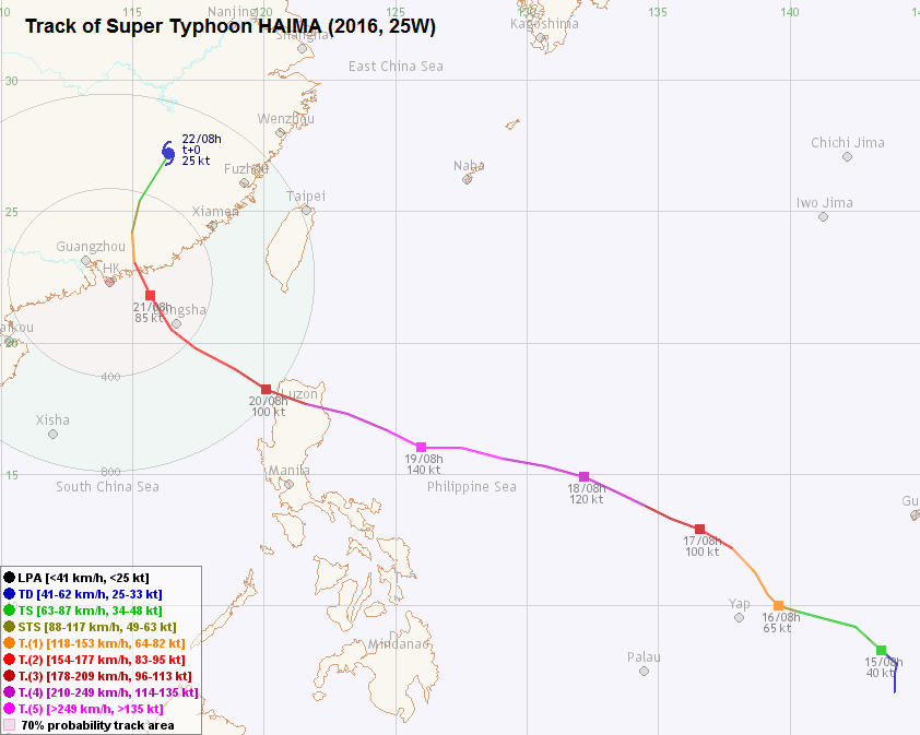
Tropical depression 25W developed in the northwest Pacific, southeast of Yap, on October 14. The subtropical ridge was covering much of the tropical Pacific north and east of the storm, leading to a projected storm track towards the northwest. 25W's convections tightened on October 15; the JMA upgraded it to tropical storm HAIMA at 8 am that morning. Various agencies predicted that HAIMA would intensify at above climatological rate as it traversed the northwest Pacific due to the combination of favourable factors, including very warm seas, low vertical wind shear and decent upper-level divergence.
HAIMA's circulation expanded significantly and became more symmetric on October 16. It intensified into a typhoon that morning and moved slightly more poleward that afternoon. The storm turned west-northwest again on October 17 as it reached the southern edge of the ridge, followed by an increase in the track speed. Both numerical models and official agencies agreed on the forecast that HAIMA would cross Luzon and enter the South China Sea before recurving due to a weakening of the ridge. A clear eye emerged from within the central dense overcast later that day; the HKO upgraded HAIMA to super typhoon strength that night.
HAIMA's central dense overcast thickened and its eye widened on October 18. The JTWC assessed the cyclone at super typhoon strength (130 knots or 241 km/h) that afternoon, and adjusted to a category-5 equivalent strength of 140 knots (259 km/h) at 8 pm. HAIMA reached peak intensity overnight, with a maximum estimated intensity of 145 knots (269 km/h) from the JTWC, 220 km/h from the HKO (revised to 230 km/h in its tropical cyclone report) and 115 knots (213 km/h) from the JMA. HAIMA started to weaken soon afterwards due to its proximity to northern Philippines. It spent another day in the sea and made landfall near midnight October 20 in northeastern Luzon.
By this time, the western edge of the subtropical ridge was near Hong Kong's longitude and had started to weaken. However, HAIMA was still firmly driven by the ridge and it crossed Luzon in less than 8 hours. It entered the South China Sea in the morning of October 20, still with appreciable strength despite the disruption to its circulation caused by the mountains. HAIMA's eye had loosened and enlarged into a banding eye.
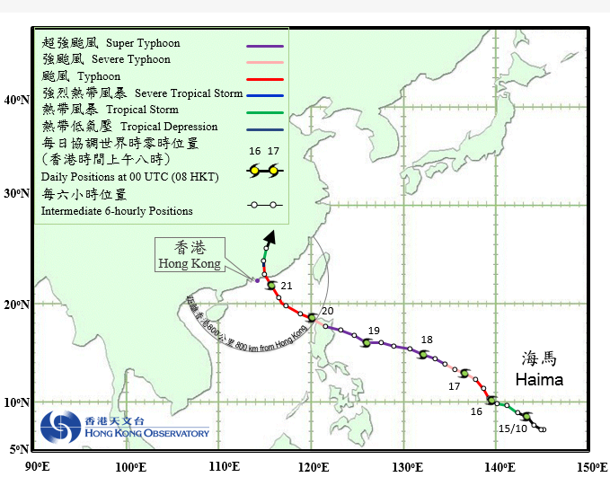
HAIMA moved west-northwest turning to northwest on October 20 and almost passed directly overhead Dongsha in the small hours of October 21. It turned further poleward in the morning of October 21 and made landfall near Shanwei at around 1 pm, as a severe typhoon according to HKO's designation. After landfall, the storm turned north and later north-northeast, weakening rapidly in the process. HAIMA weakened into a tropical storm in the night of October 21, and degenerated into an area of low pressure early on October 22.
熱帶低氣壓 25W 於 10 月 14 日在雅蒲島東南的西北太平洋上形成。當時副熱帶高壓脊正覆蓋 25W 以北及以東的大片洋面,預料該系統將向西北移動。25W 的對流於 15 日漸轉緊密,日本氣象廳於早上 8 時將其升格為熱帶風暴海馬。受惠於高海溫、低垂直風切變及良好高空輻散等有利熱帶氣旋發展的因素,官方氣象機構普遍預料海馬將在橫過西北太平洋時以高於氣候平均值速度增強。
海馬的環流於 16 日明顯擴大並變得對稱,風暴早上增強為颱風,下午其移向較北。隨著海馬於 17 日到達副高西南邊緣,它再次往西北偏西移動,移速有所提高。按照當時大氣環境,預料副高將於後期減弱,各數值模式及官方預報一致地預測海馬將橫過呂宋,繼而進入南海並轉向。17 日較後時間,海馬的中心密集雲區內發展出一清晰風眼,香港天文台遂於當晚升格風暴至超級颱風強度。
18 日,海馬的中心密集雲區變厚,風眼面積擴大,聯合颱風警報中心於下午評定其強度達超級颱風級別 (130 節或每小時 241 公里),並於下午 8 時進一步將其強度提升至達五級超級颱風的 140 節 (每小時 259 公里)。海馬於 18-19 日晚間達到其巔峰強度,聯合颱風警報中心估計強度為 145 節 (每小時 269 公里),天文台的則為每小時 220 公里 (於事後熱帶氣旋報告中上調至每小時 230 公里),而日本氣象廳的則為 115 節 (每小時 213 公里)。那時,海馬開始受陸地影響並開始減弱。它用了多一天時間橫過西北太平洋,並於 20 日近午夜時份登陸呂宋東北部。
此時,副高西緣約於香港經度並開始減弱,但海馬仍然全面受副高引導,只用了少於 8 小時便完成通過呂宋。海馬於 20 日早上進入南海;雖然環流受高山擾亂,但風暴強度仍然可觀,其中心則變得較為鬆散,發展成一較大的雲捲風眼。
海馬於 20 日向西北偏西轉西北移動,於 21 日凌晨幾乎通過東沙上空。21 日早上,海馬的移向進一步北偏,於下午 1 時左右登陸汕尾一帶,香港天文台評定其登陸時達強颱風級。登陸後,海馬向偏北轉東北偏北移動,於 21 日晚快速減弱成一熱帶風暴,繼而於 22 日初段進一步減弱為低壓區。
| Weather in Hong Kong During Approach 風暴影響時香港天氣狀況 |
Link to relevant HKO weather report bulletins: 20/10 21/10
香港天文台相關天氣報告連結:20/10 21/10
Preparations in Hong Kong were long underway before HAIMA approached as SARIKA was affecting the territory just days ago and numerical models had been exceptionally accurate in the track prediction for this recurving October cyclone. The HKO issued a "special weather tip" at noon October 19 to warn the public of HAIMA's potential threat to the territory (that it may pass within 100 km of Hong Kong), and that the #1 Standby Signal would be issued on Thursday (October 20). Affected by HAIMA's subsidence, it was sunny and hazy on October 20. The Standby Signal was issued at 8:20 am, when HAIMA was situated around 780 km southeast of Hong Kong. Handling of both empty and laden cargoes was suspended in the afternoon.
As HAIMA approached, the HKO issued the #3 Strong Wind Signal at 8:40 pm the same day. HAIMA had moved to about 430 km southeast of the territory; the Observatory also mentioned that the #8 Signal may be issued the next morning depending on HAIMA's development. Locally, winds were generally light to moderate on October 20 but started to pick up during the night, albeit still appreciably short of the strong wind threshold except at Tate's Cairn. The terminal aerodrome forecast (TAF) issued by the HKO for the Hong Kong International Airport in the morning of October 20 indicated that storm force winds of 55 knots (102 km/h) were expected during HAIMA's closest approach, with gusts reaching up to hurricane force (65 knots or 120 km/h). Strong crosswinds led to many delays and cancelled flights at the airport.
HAIMA almost made a direct hit at Dongsha Island near 2 am October 21, where a minimum sea-level pressure of 969.3 hPa was recorded. The HKO issued the Pre-No. 8 Special Announcement at 4:11 am, indicating that the #8 Signal would be issued before 6:30 am. HAIMA's outer rainbands also arrived at Hong Kong near that time. Following the development, various service cancellations were announced: ferries to outlying islands were suspended in the early morning; all daytime classes were cancelled, and so were most land-based public transport services. The #8 Northwest Gale or Storm Signal was issued at 6:10 am, when HAIMA was about 250 km east-southeast of Hong Kong. The HKO mentioned that the signal would remain in force during most of the daytime.
At most places, northwesterly winds surged following the issuance of the #8 Signal. By 10 am, storm force winds were blowing at Tate's Cairn and Waglan Island, while gales were observed at Cheung Chau. Winds at most places remained at strong force level due to the sheltering effect of winds coming in from the northwest. The wind direction gradually turned west near midday and early afternoon; this was also the time when the strongest winds were observed - in addition to the above places, gales were registered at Chek Lap Kok , Lau Fau Shan, Peng Chau, Star Ferry, Tai Mei Tuk and Tap Mun.
HAIMA made landfall near Shanwei at 1 pm; this was also the time when the storm made its closest approach to Hong Kong (110 km to the east-northeast). HAIMA's eyewall however avoided most of the territory, and therefore higher signals were unnecessary. The Observatory replaced the Northwest Signal by the Southwest Signal at 2:15 pm. The wind direction did back to the southwest in the next two hours, but HAIMA was weakening so quickly that winds at most places dropped to below gale force level by 4 pm. The Observatory issued the #3 Strong Wind Signal at 5:20 pm when HAIMA weakened into a severe tropical storm. With the exception of Tate's Cairn and Waglan Island, winds diminished further to moderate levels by 10 pm, and the Strong Wind Signal was promptly cancelled at 10:10 pm. HAIMA's rainbands also dissipated during the night, and local weather improved on October 22.
There were more than 300 reports of fallen trees during HAIMA's approach; more than 730 flights were cancelled or delayed, while 13 people were injured and sought medical assistance at the emergency unit at public hospitals.
由於時值熱帶氣旋莎莉嘉來襲不久,加上數值預報模式對此 10 月轉向風暴預測奇準,各界多一早已開始採取防風措施。香港天文台於 10 月 19 日中午發出特別天氣提示,警示市民海馬對本港的威脅 (或於 100 公里以內掠過),並指出將於周四 (20 日) 發出一號戒備信號。受海馬相關下沉氣流影響,香港於 20 日天晴有煙霞,而一號戒備信號則於當天早上 8 時 20 分發出,當時海馬集結於本港東南約 780 公里。吉櫃及重櫃交收於下午陸續暫停。
隨著海馬靠近,天文台於同日下午 8 時 40 分發出三號強風信號,當時海馬已移至香港東南方約 430 公里處。天文台亦表示將於 21 日早上,根據海馬的最新發展考慮改發八號信號。本港於 20 日風勢輕微至和緩;晚間風力開始上升,但除大老山外各處仍遠遠不及強風下限。天文台 20 日早上對香港國際機場發出的機場天氣預報估計海馬來襲時赤鱲角將吹達 55 節 (每小時 102 公里) 的暴風,陣風更達颶風程度 (65 節或每小時 120 公里)。受側風影響,機場眾多航班取消或受延誤。
海馬於 21 日上午約 2 時正面吹襲東沙島,該處錄得最低海平面氣壓 969.3 百帕。香港天文台於上午 4 時 11 分發出預警八號熱帶氣旋警告信號之特別報告,預計八號信號將最遲於上午 6 時 30 分發出。與此同時,海馬的外圍雨帶到達本港。此特別報告發出後,各方宣佈服務暫停的消息:往離島的渡輪於早上初段陸續停航、所有日校將停課、大多數陸上交通工具亦將暫停運作。八號西北烈風或暴風信號於上午 6 時 10 分發出,當時海馬集結於香港東南偏東約 250 公里。天文台同時表示八號信號將於日間大部分時間維持。
八號信號發出後本港風勢開始上揚。至上午 10 時,大老山及橫瀾島吹暴風、長洲吹烈風。由於西北風較受地形屏蔽,多處風力仍只達強風程度。中午及下午初段風向轉為偏西,大多數區域於此時錄得最高風速。除上述地方外,赤鱲角、流浮山、坪洲、天星碼頭、大美督及塔門亦吹烈風。
海馬於下午約 1 時登陸汕尾一帶,此時風暴最為接近香港,於東北偏東約 110 公里處掠過。海馬的眼牆並未觸及本港大多數地區,更高信號無需發出。天文台於下午 2 時 15 分發出八號西南烈風或暴風信號,取代西北信號。風向於之後兩小時的確逆轉至西南,但由於海馬減弱速度較快,多區風力於下午 4 時已下降至烈風程度以下。天文台於下午 5 時 20 分改發三號強風信號,海馬亦於此時減弱為強烈熱帶風暴。除大老山及橫瀾島外,至下午 10 時本港整體風勢已達和緩程度,三號信號亦於下午 10 時 10 分取消。海馬的雨帶於當晚逐漸消散,本港天氣於 22 日好轉。
海馬襲港期間,當局共接獲超過 300 宗塌樹報告,超過 730 班機取消或延誤,13 人受傷到公立醫院的急症室求診。
| Image Gallery 圖片庫 |

Figure 1 - Track predictions from various numerical models on October 16
圖 1 - 10 月 16 日部分數值模式之預測路徑
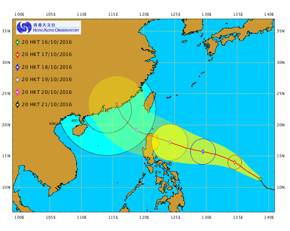

Figure 2 - Track forecasts from the HKO on October 16 (left) and October 19 (right)
圖 2 - 10 月 16 (左) 及 19 日 (右) 香港天文台的預測路徑圖

Figure 3 - Satellite image of HAIMA (right cyclone) and SARIKA (left cyclone) on October 17
圖 3 - 10 月 17 日之衛星雲圖,可見海馬 (右) 及莎莉嘉 (左) 兩個熱帶氣旋
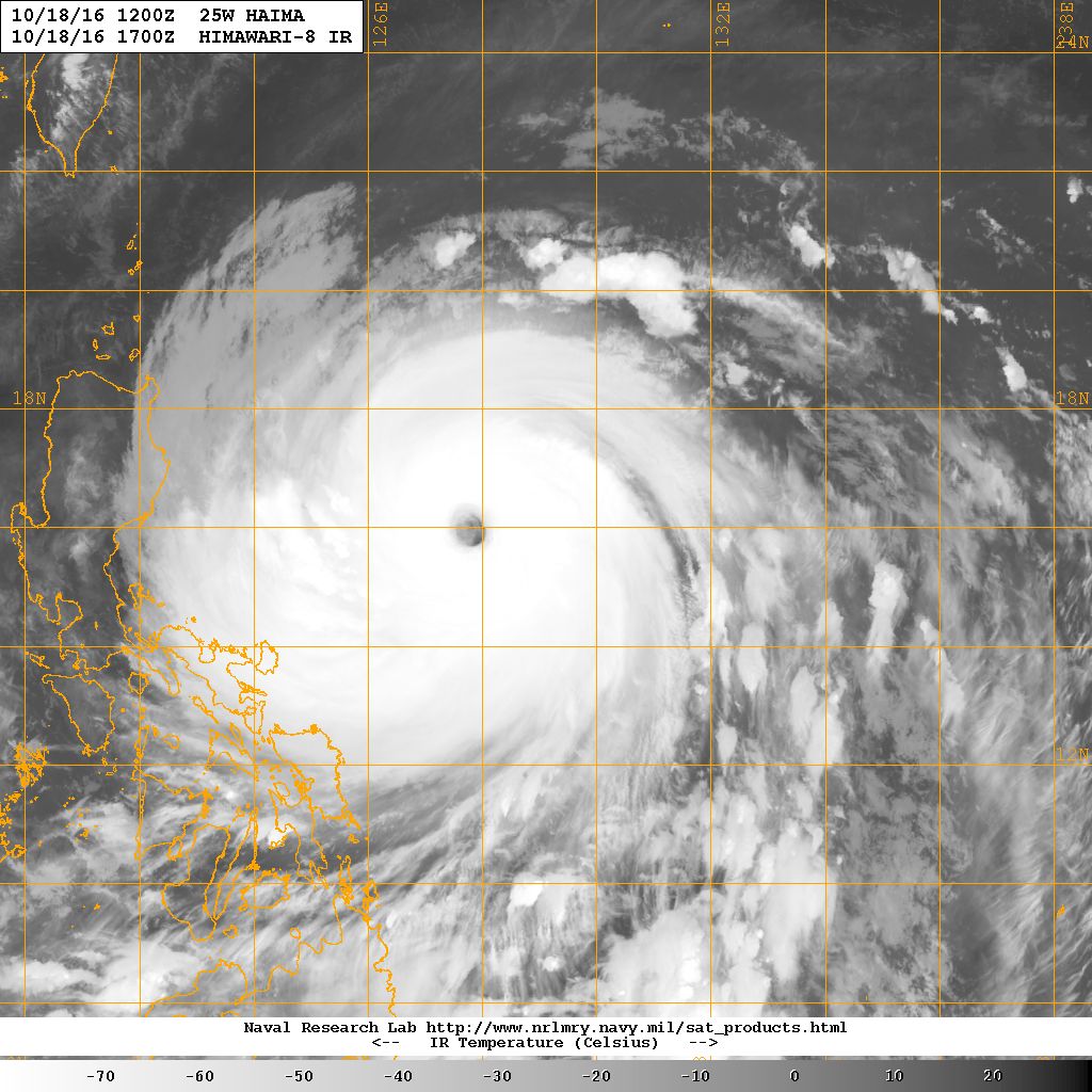

Figure 4 - Satellite images showing HAIMA at peak intensity
圖 4 - 海馬處於巔峰強度時之衛星雲圖

Figure 5 - Steering flow chart at 8 am October 19
圖 5 - 10 月 19 日上午 8 時之駛流場圖
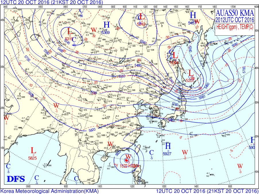
Figures 6 - 500 hPa upper level analysis chart at 8 pm October 20
圖 6 - 10 月 20 日下午 8 時之 500 百帕高空天氣圖

Figure 7 - The terminal aerodrome forecast (TAF) issued by the HKO in the morning of October 20
圖 7 - 10 月 20 日早上天文台發出的機場天氣預報
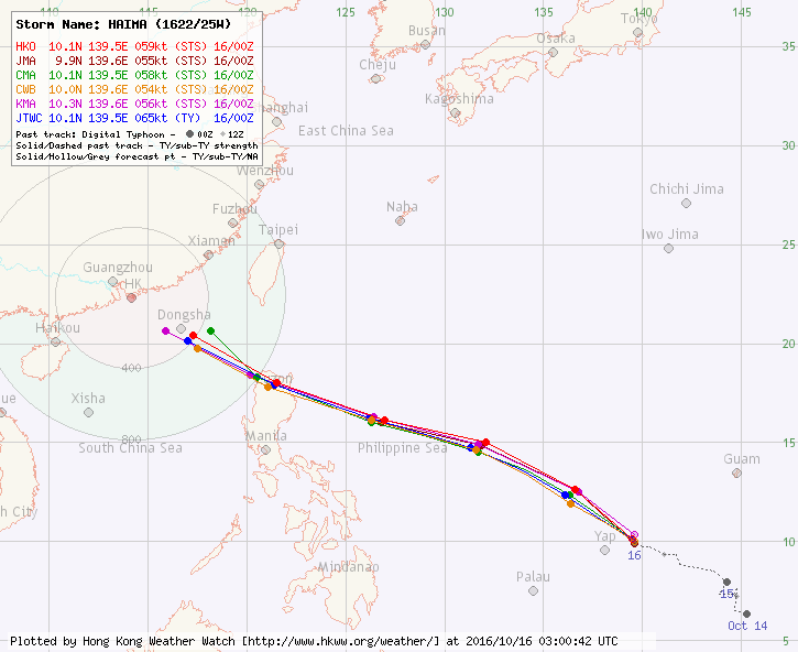

Figure 8 - Forecast tracks from various official agencies in the morning of October 16 (left) and in the afternoon of October 19 (right)
圖 8 - 10 月 16 日早上 (左) 及 19 日下午 (右) 各官方氣象台之預測路徑

Figure 9 - HAIMA travelling in the South China Sea; note its large banding eye
圖 9 - 海馬正橫過南海,留意其大型雲捲風眼

Figure 10 - Wind field analysis at 9:02 pm October 20
圖 10 - 10 月 20 日下午 9 時 02 分之風場分析圖

Figure 11 - Wind speed (in m/s) and sea level pressure (in hPa) observed at Dongsha Island around HAIMA's approach (plot created using data from the CWB of Taiwan)
圖 11 - 海馬靠近東沙島時該處所錄得之風速 (米每秒) 及氣壓 (百帕) 圖 (使用台灣中央氣象局數據繪製)

Figure 12 - Calculated wind field distribution chart at 8 am October 21
圖 12 - 10 月 21 日上午 8 時之估算風場分布圖

Figure 13 - Visible imagery of HAIMA near landfall at Shanwei
圖 13 - 海馬登陸汕尾前之可見光衛星雲圖

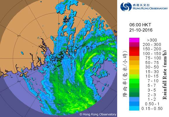


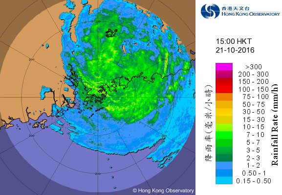
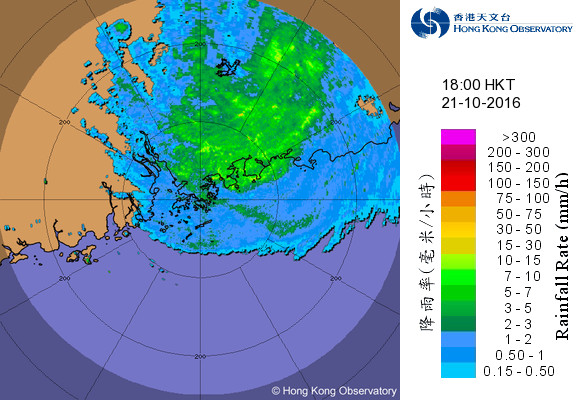
Figure 14 - Radar images at 3-hour intervals from 3 am to 6 pm October 21
圖 14 - 10 月 21 日上午 3 時至下午 6 時每三小時之雷達圖


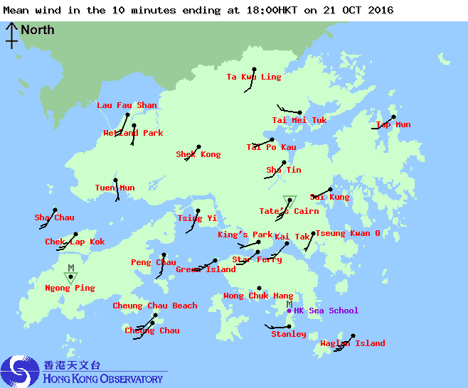
Figure 15 - Local wind disitribution maps at 3-hour intervals from 3 am to 6 pm October 21
圖 15 - 10 月 21 日上午 3 時至下午 6 時每三小時之本港風勢分布圖


Figure 16 - Wind speed time series at Cheung Chau, Lau Fau Shan, Chek Lap Kok, Star Ferry and Waglan Island (top to bottom) on October 21
圖 16 - 長洲、流浮山、赤鱲角、天星碼頭及橫瀾島 (上至下) 於 10 月 21 日的風速時間序列圖

Figure 17 - Sea level pressure time series at the Hong Kong Observatory on October 21
圖 17 - 香港天文台於 10 月 21 日的海平面氣壓時間序列圖
| Winds Recorded at Reference Stations 參考站所錄得的風速 |
| Station 風速站 |
Max. 10-min avg. wind speed 最高十分鐘平均風速 |
Beaufort classification 蒲福氏風級分類 |
| Chek Lap Kok 赤鱲角 | 71 km/h | GALE 烈風 |
| Cheung Chau 長洲 | 75 km/h | GALE 烈風 |
| Kai Tak 啟德 | 50 km/h | STRONG 強風 |
| Lau Fau Shan 流浮山 | 75 km/h | GALE 烈風 |
| Sai Kung 西貢 | 42 km/h | STRONG 強風 |
| Sha Tin 沙田 | 29 km/h | Moderate 和緩 |
| Ta Kwu Ling 打鼓嶺 | 25 km/h | Moderate 和緩 |
| Tsing Yi (SHL) 青衣蜆殼油庫 | 56 km/h | STRONG 強風 |
| Number of stations recording at least STRONG force (force 6 - 7) winds: | 6 |
| Number of stations recording at least GALE force (force 8 - 9) winds: | 3 |
| Number of stations recording at least STORM force (force 10 - 11) winds: | 0 |
| Number of stations recording HURRICANE force (force 12) winds: | 0 |
| 錄得 強風 (6 - 7 級) 或更高風速的站數: | 6 |
| 錄得 烈風 (8 - 9 級) 或更高風速的站數: | 3 |
| 錄得 暴風 (10 - 11 級) 或更高風速的站數: | 0 |
| 錄得 颶風 (12 級) 風速的站數: | 0 |
| Charts and Figures 各項數據 |
Table 1: Track data from HKWW:
表一 : 香港天氣觀測站之路徑資料
YYMMDDZZ Lat Long Wind |
Table 2: Maximum gust and hourly average wind speed recorded in Hong Kong from HKO:
表二 : 香港天文台公佈的各站最高每小時平均風力和陣風數據 (英文)
| Station | Maximum Gust |
Maximum Hourly Mean Wind |
||||||
|---|---|---|---|---|---|---|---|---|
| Direction |
Speed(km/h) |
Date/Month |
Time |
Direction |
Speed(km/h) |
Date/Month |
Time |
|
Bluff Head (Stanley) |
NW |
68 |
21/10 |
10:06 |
NW |
40 |
21/10 |
11:00 |
Central Pier |
W |
85 |
21/10 |
09:31 |
W |
51 |
21/10 |
12:00 |
Cheung Chau |
WNW |
108 |
21/10 |
12:21 |
WNW |
67 |
21/10 |
13:00 |
Cheung Chau Beach |
WNW |
101 |
21/10 |
11:14 |
W |
59 |
21/10 |
13:00 |
W |
101 |
21/10 |
12:19 |
|||||
Green Island |
WNW |
96 |
21/10 |
12:50 |
NNW |
67 |
21/10 |
08:00 |
Hong Kong International Airport |
NW |
85 |
21/10 |
11:09 |
WNW |
65 |
21/10 |
12:00 |
Kai Tak |
W |
90 |
21/10 |
09:22 |
W |
43 |
21/10 |
11:00 |
King's Park |
WNW |
79 |
21/10 |
13:19 |
WNW |
31 |
21/10 |
13:00 |
WNW |
31 |
21/10 |
14:00 |
|||||
Lau Fau Shan |
W |
110 |
21/10 |
13:19 |
W |
70 |
21/10 |
13:00 |
North Point |
WSW |
88 |
21/10 |
13:49 |
WSW |
58 |
21/10 |
14:00 |
Peng Chau |
SW |
101 |
21/10 |
11:35 |
WSW |
59 |
21/10 |
11:00 |
Ping Chau |
W |
68 |
21/10 |
13:02 |
W |
38 |
21/10 |
15:00 |
Sai Kung |
NW |
79 |
21/10 |
09:40 |
NW |
38 |
21/10 |
10:00 |
Sha Chau |
W |
68 |
21/10 |
12:23 |
SSW |
43 |
21/10 |
19:00 |
Sha Lo Wan |
SSW |
72 |
21/10 |
16:41 |
WSW |
31 |
21/10 |
14:00 |
Sha Tin |
WSW |
75 |
21/10 |
12:35 |
SW |
23 |
21/10 |
16:00 |
Shek Kong |
W |
58 |
21/10 |
11:58 |
W |
22 |
21/10 |
12:00 |
Star Ferry (Kowloon) |
W |
88 |
21/10 |
12:43 |
W |
63 |
21/10 |
13:00 |
Ta Kwu Ling |
WSW |
54 |
21/10 |
12:16 |
SSW |
20 |
21/10 |
18:00 |
Tai Mei Tuk |
WNW |
104 |
21/10 |
12:47 |
W |
63 |
21/10 |
13:00 |
Tai Mo Shan |
WNW |
155 |
21/10 |
12:33 |
WNW |
115 |
21/10 |
13:00 |
Tai Po Kau |
W |
88 |
21/10 |
11:50 |
W |
47 |
21/10 |
13:00 |
Tap Mun |
W |
106 |
21/10 |
13:33 |
W |
62 |
21/10 |
12:00 |
Tate's Cairn |
WNW |
122 |
21/10 |
10:40 |
NW |
77 |
21/10 |
10:00 |
Tseung Kwan O |
WNW |
52 |
21/10 |
10:40 |
NNW |
19 |
21/10 |
07:00 |
Tsing Yi Shell Oil Depot |
WNW |
85 |
21/10 |
12:29 |
WNW |
51 |
21/10 |
13:00 |
Tuen Mun Government Offices |
WNW |
96 |
21/10 |
12:03 |
WNW |
40 |
21/10 |
13:00 |
Waglan Island |
W |
115 |
21/10 |
12:35 |
SW |
83 |
21/10 |
16:00 |
SW |
83 |
21/10 |
17:00 |
|||||
Wetland Park |
WNW |
68 |
21/10 |
11:08 |
WNW |
22 |
21/10 |
12:00 |
Wong Chuk Hang |
NNW |
88 |
21/10 |
10:36 |
NNW |
31 |
21/10 |
11:00 |
Table 3: Rainfall (in millimetres) contributed by HAIMA from HKO (figures in brackets are based on incomplete hourly data):
表三 : 香港天文台公佈的各站雨量資料 (英文) (方括號內之數據由不完整之每小時資料擷取)
| Station | 20 Oct | 21 Oct | Total Rainfall (mm) |
|
|---|---|---|---|---|
| Hong Kong Observatory (HKO) | 0.0 |
72.5 |
72.5 |
|
| Hong Kong International Airport (HKA) |
0.0 |
24.4 |
24.4 |
|
| Cheung Chau (CCH) | [ 0.0] |
[41.5] |
[41.5] |
|
| H23 | Aberdeen | 0.0 |
67.5 |
67.5 |
| N05 | Fanling | 0.5 |
83.0 |
83.5 |
| N13 | High Island | 0.0 |
91.0 |
91.0 |
| K04 | Jordan Valley | 0.0 |
90.0 |
90.0 |
| N06 | Kwai Chung | 0.0 |
95.0 |
95.0 |
| H12 | Mid Levels | 0.0 |
76.0 |
76.0 |
| N09 | Sha Tin | 0.5 |
95.5 |
96.0 |
| H19 | Shau Kei Wan | 0.0 |
91.0 |
91.0 |
| SEK | Shek Kong | [0.0] |
[61.0] |
[61.0] |
| K06 | So Uk Estate | 0.0 |
96.0 |
96.0 |
| R31 | Tai Mei Tuk | [0.0] |
122.5 |
[122.5] |
| R21 | Tap Shek Kok | 0.0 |
42.0 |
42.0 |
| N17 | Tung Chung | [0.0] |
[0.0] |
[0.0] |
| TMR | Tuen Mun Reservoir | 0.0 |
37.2 |
37.2 |
Last Accessed 最近訪問日期: Sat Apr 20 2024 02:08:34 HKT
Last Modified 最近修訂日期: Mon Jul 24 2023
