
TC Watch / 熱帶氣旋 > Selected TC Review / 重要熱帶氣旋回顧 > 201805W (EWINIAR 艾雲尼) [Refresh 更新]
 201805W (EWINIAR 艾雲尼) - Profile 檔案 201805W (EWINIAR 艾雲尼) - Profile 檔案 |
(First draft issued on June 13, 2018; final version issued on July 9, 2018)
(初稿於 2018 年 6 月 13 日發出,最後版本於 2018 年 7 月 9 日上載)
Brief profile of EWINIAR | 艾雲尼小檔案:
| JTWC number 聯合颱風警報中心 (JTWC) 號碼 | 05W |
| International number 國際編號 | 1804 |
| Period of existence 生存時期 (JTWC) | 2018/06/02 14 HKT - 2018/06/08 20 HKT |
| Lifetime 壽命 (JTWC) | 6.25 days 日 |
| Maximum 1-minute wind (JTWC) JTWC 一分鐘平均最高中心風速 | 35 knots 節 (Tropical Storm 熱帶風暴) |
| Minimum pressure (JTWC) JTWC 最低氣壓 | 994 hPa 百帕 |
| Highest TC signal by HKO 香港天文台發出最高熱帶氣旋警告信號 |
3 (Strong Wind Signal 強風信號) |
| Closest point of approach by HKO 香港天文台所示之最接近距離 |
WNW 200 km (real-time warning 實時報告 and 及 TC report 熱帶氣旋報告) |
| Time of closest approach by HKO 香港天文台所示之最接近時間 |
2018/06/08 13 HKT (real-time warning 實時報告 and 及 TC report 熱帶氣旋報告) |
| Lowest pressure recorded at HKO 香港天文台錄得的最低氣壓 |
998.7 hPa 百帕 (2018/06/08 17:01 HKT) |
TC signals in Hong Kong 香港曾經生效的熱帶氣旋警告:
| Signal 信號 |
Date and time 日期和時間 |
Distance from HK 與香港的距離 |
Predicted movement 預測移動趨勢 |
Max. 10-min winds 中心最高十分鐘平均風速 |
 |
2018/06/05 (TUE) 11:20 HKT | SSW 600 km | N at 12 km/h | 55 km/h (30 knots, TD) |
 |
2018/06/07 (THU) 12:40 HKT | WSW 330 km | N/NNE at 10 km/h | 75 km/h (40 knots, TS) |
|
2018/06/08 (FRI) 15:40 HKT | WNW 210 km | N/NNE Slowly | 55 km/h (30 knots, TD) |
 |
2018/06/08 (FRI) 18:20 HKT | NW 200 km | N/NNE Slowly | 55 km/h (30 knots, TD) |
Percentile rank among storms with #3 Signal (at compilation of this review)*: *This measures the relative wind strength in Hong Kong caused by this storm compared with others that share the same signal. 指標顯示此風暴相對於其他發出同樣信號的風暴為香港帶來之風力強度 For more information, please refer to Wind Speed Data for TCs that Have Affected Hong Kong. 更多資訊載於 影響香港氣旋之風速數據 頁 |
Overall: 總計: |
|
Weak 弱 |
|||
| Component Ranks 分部等級 | ||||||
| Reference stations: 參考站: |
|
Weak 弱 |
||||
| Victoria Harbour: 維多利亞港: |
|
Weak 弱 |
||||
| Urban: 市區: |
|
Weak 弱 |
||||
| Offshore & high ground 離岸和高地: |
|
Weak 弱 |
||||
Cyclones that attained similar rating (with signal #3): MAWAR (2017), DIANMU (2016), NALGAE (2011), NANGKA (2009), DAN (1999), PENNY (1998) 相近級別之熱帶氣旋 (三號信號):瑪娃 (2017)、電母 (2016)、尼格 (2011)、浪卡 (2009)、丹尼 (1999)、彭妮 (1998) |
||||||
IR imagery animation 紅外線雲圖動畫:
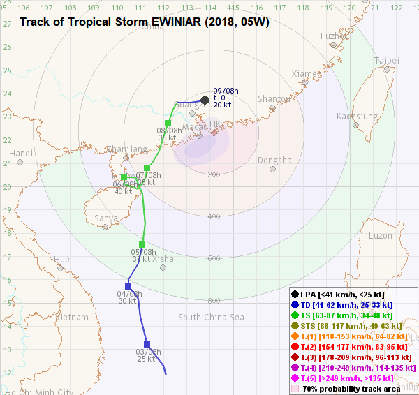
TC track from HKWW 本站的熱帶氣旋路徑圖:
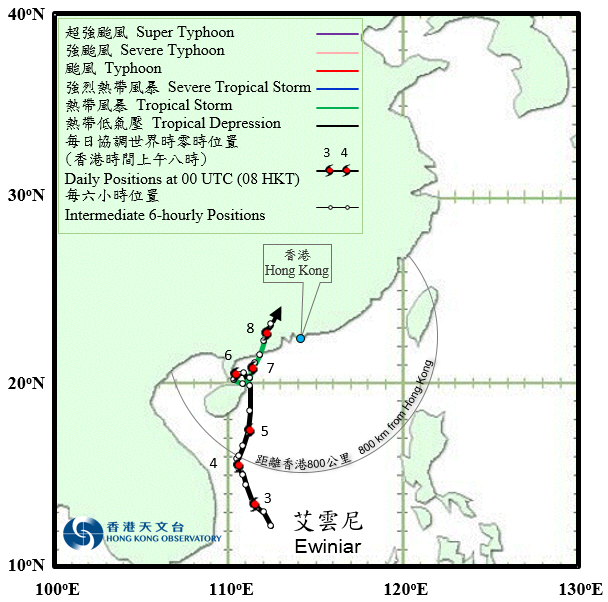
TC track from HKO 天文台的熱帶氣旋路徑圖:
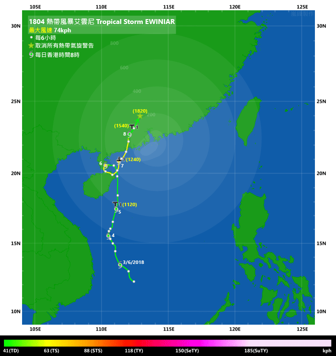
TC track with signal information 附有熱帶氣旋警告信號資料的路徑圖:
(Track figure courtesy of Lorenzo. Data from HKO. 鳴謝 Lorenzo 提供路徑圖,資料取自天文台)
| Past HKWW Bulletins 本站發佈 |
Please click here for bulletins on this tropical cyclone. 請按這裡。
| Storm Development Overview 風暴發展概覽 |
Unless otherwise stated, all times below are in Hong Kong Standard Time (UTC+8)
除非特別註明,下文時間均為香港標準時間 (協調世界時加 8 小時)
EWINIAR is the first system to necessitate tropical cyclone signals in Hong Kong this year.
After a prolonged period of dominance of the subtropical ridge in May, convective activities developed in southern South China Sea in the beginning of June. The disturbance, numbered as 99W, strengthened into tropical depression 05W on June 2. 05W was situated in the western periphery of the subtropical ridge, and was expected to move north and approach Hainan. However, there was substantial disagreement among various numerical models on its future track.
05W remained as a weak system in the next two days as it suffered from moderate to strong southwesterly vertical wind shear. It failed to gather much clouds around its centre until June 5, when shear started to relax and convective bursts could be seen developing. It took another day before 05W's spiraling characteristics became prominent, prompting the JMA to upgrade it into tropical storm EWINIAR at 8 am June 6. EWINIAR was reaching the Leizhou Peninsula at that time, and a weakening in the steering flow caused the storm to decelerate once again.
EWINIAR spent the day completing an anti-clockwise loop around Leizhou Peninsula and the Qiongzhou Strait, and made another landfall at northeastern Hainan at nighttime. Due to land interaction, EWINIAR's convections thinned but the core remained intact as could be seen on Hainan's radar images. The storm resumed its north to north-northeastward motion in the morning of June 7, and was able to intensify in northern South China Sea prior to landfall in coastal Guangdong.
According to Chinese authorities, EWINIAR made its final landfall near Yangjiang, Guangdong at around 8:30 pm June 7, carrying winds of up to force 8. Some numerical models had previously predicted EWINIAR to turn east immediately after landfall, but this did not materialize as the storm continued to move north-northeast inland. It weakened at a relatively slow pace due to the continued supply of moisture from the south, and was downgraded into a tropical storm by the HKO as late as in the afternoon of June 8. Because of the weakening ridge, EWINIAR stagnated again and turned east. It weakened into an area of low pressure near Guangzhou in the morning of June 9*. It is worth noting that the JMA retained EWINIAR's tropical storm status until 8 am June 9, when it downgraded the system north of Hong Kong.
* In HKO's TC report, EWINIAR was described to have weakened into an area of low pressure by the night of June 8.
艾雲尼為本年首個令香港天文台發出熱帶氣旋警告的系統。
經過 5 月副熱帶高壓脊長時間支配後,6 月初南海南部開始出現對流活動。熱帶擾動 99W 於 6 月 2 日增強為熱帶低氣壓 05W。05W 當時處於副高西面,預料向偏北移動並靠近海南,但各數值預報模式對其未來路徑分歧較大。
05W 於隨後兩日受中等至強烈西南垂直風切變影響而未能發展,中心附近雲層稀薄,直至 5 日垂直風切變有所放緩,05W 中心附近可見對流爆發。一日後,05W 的螺旋性轉佳,日本氣象廳於 6 日上午 8 時將其升格為熱帶風暴艾雲尼。當時艾雲尼正靠近雷州半島,而由於流場減弱,風暴再次減速移動。
艾雲尼用了一天時間,於雷州半島及瓊州海峽一帶逆時針轉了一圈,晚間於海南東北部再次登陸。受地形影響,艾雲尼的對流變得稀薄,但從海南雷達可見其中心仍然完整。艾雲尼於 7 日早上開始回復向北至東北偏北移動,並於登陸廣東沿岸前增強。
按中國官方宣佈,艾雲尼於 7 日下午 8 時 30 分左右登陸廣東陽江一帶,登陸時風力達 8 級。部分數值模式先前預測艾雲尼登陸後即轉向偏東移動,但此並未發生,風暴登陸後繼續向東北偏北移入內陸。由於南方不斷有水氣供應,艾雲尼減弱速度較慢,天文台直至 8 日下午才將其降格為熱帶低氣壓。隨著副高減弱,艾雲尼減速並轉東移,於 9 日早上在廣州附近減弱為低壓區*。值得留意的是日本氣象廳一直維持艾雲尼的熱帶風暴強度,直至 9 日上午 8 時才將其降格,路徑圖顯示當時它已到達香港以北。
* 天文台於其熱帶氣旋報告表示艾雲尼於 6 月 8 日晚減弱為低壓區。
| Weather in Hong Kong During Approach 風暴影響時香港天氣狀況 |
Link to relevant HKO weather report bulletins:
5/6 ●
6/6 ●
7/6 ●
8/6
香港天文台相關天氣報告連結:
5/6 ●
6/6 ●
7/6 ●
8/6
EWINIAR came to within 800 km of Hong Kong on June 4. There were some scattered showers in Hong Kong on that day. The HKO issued the #1 Standby Signal at 11:20 am on June 5 when the storm was around 600 km from the territory. A rare procedural error from the Observatory allowed the signal to be displayed on its website at 10:40 am, while its mobile application even dated back the announcement to 9:25 am. The weather turned unstable as induced convections associated with EWINIAR affected the territory, and 28.2 mm of rain was recorded at the Observatory on June 5.
Heavy showers affected Hong Kong on June 6; the HKO maintained a low possibility for upgrading the signal that day and noted the erratic movement of the cyclone. The first Amber Rainstorm Warning of the year and the Special Announcement on Flooding in the Northern New Territories were issued just after 1 pm, with the former lasting until 2:50 pm and the latter 6 pm. Northeastern Hong Kong received the most rainfall that day with areas such as Tai Po reaching 150 mm, while more than 50 mm of rain was recorded over most parts of the territory. A surge in wind speed associated with the rainbands was observed later that night; strong force winds were blowing in offshore areas such as Cheung Chau, and on high grounds.
Early on June 7, the Observatory mentioned that raising the signal before 10 am would be unlikely. However, as EWINIAR was approaching and had the potential to strengthen, the Observatory later indicated a possibility of issuing a higher signal by 2 pm. The Landslip Warning was issued in the morning due to the prolonged rainfall. The #3 Strong Wind Signal was eventually issued at 12:40 pm when EWINIAR was at a distance of 330 km west-southwest of Hong Kong. Winds did not strengthen further following the issue of the signal, but strong winds were observed occasionally during the night. A waterspout was spotted in Cheung Chau towards dusk that day amidst the unstable weather.
After EWINIAR's landfall, the rainbands associated with its core propagated eastward and reached Hong Kong in the small hours of June 8. The Amber Rainstorm Warning was issued at 6:50 am; the rain was especially heavy between 8 and 9 am, but it was not until 11:30 am that the Observatory decided to raise the alert to the Red Rainstorm Warning, way after the peak of heaviest rainfall. This warning lasted only 1 hour and was replaced by the Amber warning, which was cancelled at 2:15 pm. As winds moderated in the afternoon, the #1 Standby Signal was issued at 3:40 pm to replace the #3 Signal. The #1 Signal was also cancelled at 6:20 pm. Following EWINIAR's degeneration, its rainbands also started to disintegrate and the Landslip Warning was cancelled at 3:50 pm.
The weather improved gradually over the weekend. Between June 4 and June 9, a total rainfall of 221.3 mm was recorded at the HK Observatory. This brought an end to a period of extreme dryness in middle to late May.
艾雲尼於 6 月 4 日進入香港 800 公里範圍,當天香港有零散驟雨。天文台於 5 日上午 11 時 20 分發出一號戒備信號,當時風暴距離香港約 600 公里。信號發出前天文台程序出錯,誤於上午 10 時 40 分已於網頁宣告信號生效,手機程式中更指信息於上午 9 時 25 分發出。受艾雲尼引發的對流活動影響,香港天氣轉趨不穩定,天文台當天共錄得 28.2 毫米雨量。
6 日本港有大驟雨,天文台指當天改發更高信號機會不大,並提及風暴路徑較為飄忽。本年首個黃色暴雨警告及新界北部水浸特別報告分別於下午 1 時過後發出,前者維持至下午 2 時 50 分,而後者更於下午 6 時才取消。當天新界東北部雨勢最大,大埔等地區錄得超過 150 毫米雨量,而香港大部分地區雨量亦達 50 毫米。受雨帶影響,當晚較後時間風力有所增強,高地及離岸地區如長洲吹強風。
天文台於 7 日早段表示上午 10 時前改發更高信號機會不大,但隨著艾雲尼靠近及有增強之勢,天文台之後表示會於下午 2 時前考慮改發信號。由於雨勢持續,山泥傾瀉警告於當日早上發出。三號強風信號最終於下午 12 時 40 分發出,當時艾雲尼位於香港西南偏西約 330 公里。信號生效後風勢並未進一步增強,但晚間仍間中吹強風。而不穩定天氣繼續影響本港,當天傍晚有市民於長洲發現水龍捲的蹤跡。
艾雲尼登陸後,其中心附近的雨帶向東發展,並於 8 日凌晨到達本港。天文台於上午 6 時 50 分發出黃色暴雨警告;上午 8 至 9 時左右雨勢最大,但天文台遲至上午 11 時 30 分、降雨區已開始移離本港之時才改發紅色暴雨警告。一小時後,此警告被黃色暴雨警告取代,並持續至下午 2 時 15 分取消。隨著風勢於下午減弱,天文台於下午 3 時 40 分改發一號戒備信號,繼而於下午 6 時 20 分取消該信號。而由於艾雲尼繼續消散,其雨帶亦開始瓦解,山泥傾瀉警告於下午 3 時 50 分取消。
本港天氣於周末好轉。天文台於 6 月 4 至 9 日間共錄得 221.3 毫米雨量,結束了 5 月中後期持續多時的乾旱天氣。
| Image Gallery 圖片庫 |

Figure 1 - Numerical model predictions on May 30 indicating tropical cyclone development in the South China Sea
圖 1 - 5 月 30 日數值模式預報預示熱帶氣旋於南海發展

Figure 2 - Vertical wind shear distribution map on June 4
圖 2 - 6 月 4 日之垂直風切變分佈圖

Figure 3 - Steering flow map on June 7
圖 3 - 6 月 7 日之駛流場圖

Figure 4 - Satellite image of EWINIAR landfalling at Leizhou Peninsula on June 6
圖 4 - 6 月 6 日艾雲尼登陸雷州半島之衛星雲圖

Figure 5 - Forecast track from different official agencies on June 6
圖 5 - 6 月 6 日各官方氣象台之預測路徑


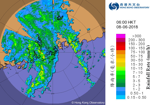

Figure 6 - Radar images at 4-hour intervals from 10 pm June 7 to 10 am June 8
圖 6 - 6 月 7 日下午 10 時至 8 日上午 10 時每四小時之雷達圖

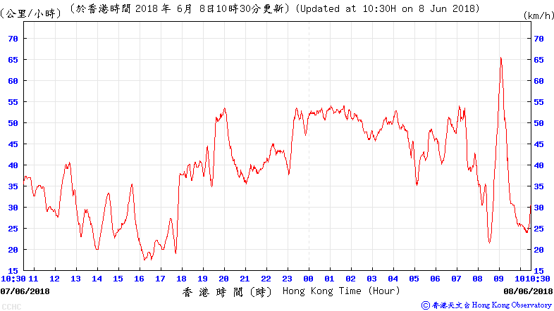

Figure 7 - Wind speed time series at Chek Lap Kok, Cheung Chau and Tate's Cairn (top to bottom) on June 7 and 8
圖 7 - 赤鱲角、長洲及大老山 (上至下) 於 6 月 7 至 8 日之風速時間序列圖


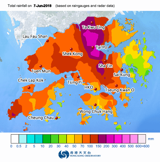
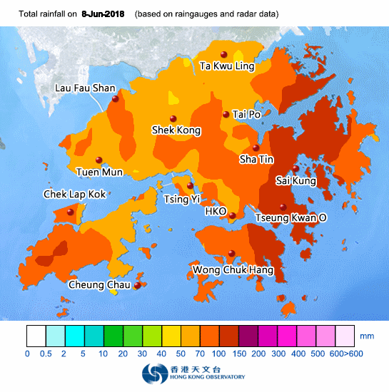
Figure 8 - Rainfall distribution maps between June 5 and June 8
圖 8 - 6 月 5 至 8 日之雨量分佈圖


Figure 9 - Waterspout captured by HKO's webcams at Cheung Chau on June 7
圖 6 - 6 月 7 日天文台網絡攝影機拍下的水龍捲
| Winds Recorded at Reference Stations 參考站所錄得的風速 |
| Station 風速站 |
Max. 10-min avg. wind speed 最高十分鐘平均風速 |
Beaufort classification 蒲福氏風級分類 |
| Chek Lap Kok 赤鱲角 | 48 km/h | STRONG 強風 |
| Cheung Chau 長洲 | 66 km/h | GALE 烈風 |
| Kai Tak 啟德 | 37 km/h | Fresh 清勁 |
| Lau Fau Shan 流浮山 | 33 km/h | Fresh 清勁 |
| Sai Kung 西貢 | 43 km/h | STRONG 強風 |
| Sha Tin 沙田 | 27 km/h | Moderate 和緩 |
| Ta Kwu Ling 打鼓嶺 | 20 km/h | Moderate 和緩 |
| Tsing Yi (SHL) 青衣蜆殼油庫 | 33 km/h | Fresh 清勁 |
| Number of stations recording at least STRONG force (force 6 - 7) winds: | 3 |
| Number of stations recording at least GALE force (force 8 - 9) winds: | 1 |
| Number of stations recording at least STORM force (force 10 - 11) winds: | 0 |
| Number of stations recording HURRICANE force (force 12) winds: | 0 |
| 錄得 強風 (6 - 7 級) 或更高風速的站數: | 3 |
| 錄得 烈風 (8 - 9 級) 或更高風速的站數: | 1 |
| 錄得 暴風 (10 - 11 級) 或更高風速的站數: | 0 |
| 錄得 颶風 (12 級) 風速的站數: | 0 |
| Charts and Figures 各項數據 |
Table 1: Track data from HKWW:
表一 : 香港天氣觀測站之路徑資料
YYMMDDZZ Lat Long Wind |
Table 2: Maximum gust and hourly average wind speed recorded in Hong Kong from HKO:
表二 : 香港天文台公佈的各站最高每小時平均風力和陣風數據 (英文)
| Station | Maximum Gust | Maximum Hourly Mean Wind | ||||||
|---|---|---|---|---|---|---|---|---|
| Direction | Speed (km/h) |
Date/Month | Time | Direction | Speed (km/h) |
Date/Month | Time | |
| Bluff Head (Stanley) | SSE | 67 | 7/6 | 03:45 | SSE | 34 | 8/6 | 14:00 |
| Central Pier | SE | 49 | 8/6 | 13:16 | ESE | 23 | 7/6 | 20:00 |
| Cheung Chau | S | 87 | 8/6 | 09:03 | ESE | 52 | 8/6 | 01:00 |
| Cheung Chau Beach | S | 67 | 8/6 | 09:00 | E | 45 | 8/6 | 00:00 |
| Hong Kong International Airport | SSE | 65 | 7/6 | 04:04 | ESE | 34 | 8/6 | 01:00 |
| Kai Tak | E | 62 | 8/6 | 00:52 | ESE | 31 | 8/6 | 08:00 |
| King's Park | SSE | 52 | 5/6 | 13:06 | E | 20 | 6/6 | 23:00 |
| E | 20 | 7/6 | 00:00 | |||||
| Lau Fau Shan | SE | 54 | 7/6 | 04:58 | SE | 25 | 8/6 | 16:00 |
| North Point | E | 45 | 7/6 | 07:27 | E | 20 | 7/6 | 19:00 |
| Peng Chau | SE | 56 | 7/6 | 10:04 | ESE | 30 | 8/6 | 01:00 |
| Ping Chau | SSE | 38 | 8/6 | 12:16 | SSE | 9 | 8/6 | 15:00 |
| Sai Kung | S | 67 | 5/6 | 13:09 | SSE | 31 | 8/6 | 09:00 |
| Sha Chau | SSW | 79 | 8/6 | 07:53 | SE | 40 | 8/6 | 01:00 |
| Sha Lo Wan | ESE | 72 | 8/6 | 01:56 | ESE | 31 | 8/6 | 02:00 |
| Sha Tin | SE | 47 | 8/6 | 04:49 | SE | 19 | 8/6 | 05:00 |
| SE | 19 | 8/6 | 08:00 | |||||
| Shek Kong | E | 41 | 8/6 | 07:28 | ENE | 12 | 6/6 | 18:00 |
| E | 12 | 7/6 | 10:00 | |||||
| E | 12 | 8/6 | 08:00 | |||||
| Star Ferry (Kowloon) | E | 59 | 7/6 | 03:58 | ESE | 31 | 8/6 | 01:00 |
| E | 31 | 8/6 | 02:00 | |||||
| Ta Kwu Ling | E | 40 | 8/6 | 02:34 | ENE | 14 | 7/6 | 21:00 |
| ENE | 14 | 8/6 | 00:00 | |||||
| Tai Mei Tuk | E | 54 | 7/6 | 19:59 | E | 30 | 7/6 | 21:00 |
| Tai Mo Shan | SE | 104 | 7/6 | 04:13 | SE | 68 | 8/6 | 02:00 |
| Tai Po Kau | ESE | 51 | 7/6 | 00:48 | ESE | 23 | 8/6 | 00:00 |
| Tap Mun | ESE | 72 | 8/6 | 02:16 | E | 49 | 7/6 | 23:00 |
| Tate's Cairn | S | 79 | 8/6 | 08:41 | S | 45 | 8/6 | 09:00 |
| Tseung Kwan O | ESE | 45 | 8/6 | 00:28 | E | 14 | 8/6 | 01:00 |
| Tsing Yi Shell Oil Depot | SE | 58 | 8/6 | 07:51 | SE | 27 | 8/6 | 10:00 |
| Tuen Mun Government Offices | SSE | 54 | 7/6 | 03:19 | SSE | 22 | 8/6 | 10:00 |
| Wetland Park | S | 45 | 7/6 | 04:56 | SSE | 16 | 8/6 | 16:00 |
| Wong Chuk Hang | SE | 54 | 6/6 | 23:07 | E | 19 | 8/6 | 08:00 |
Table 3: Rainfall (in millimetres) contributed by EWINIAR from HKO (figures in brackets are based on incomplete hourly data):
表三 : 香港天文台公佈的各站雨量資料 (英文) (方括號內之數據由不完整之每小時資料擷取)
| Station | 5-Jun | 6-Jun | 7-Jun | 8-Jun | Total Rainfall (mm) |
|
|---|---|---|---|---|---|---|
| Hong Kong Observatory | 28.2 | 58.3 | 47.4 | 70.2 | 204.1 | |
| Hong Kong International Airport (HKA) | 17.8 | 74.4 | 83.4 | 71.9 | 247.5 | |
| Cheung Chau (CCH) | [35.5] | 134.0 | [35.5] | [57.0] | [262.0] | |
| H23 | Aberdeen | 49.0 | 39.0 | 52.0 | 70.0 | 210.0 |
| N05 | Fanling | 38.5 | 130.5 | 225.5 | 71.0 | 465.5 |
| N13 | High Island | 38.5 | 41.0 | 30.5 | 93.5 | 203.5 |
| K04 | Jordan Valley | 39.5 | 52.5 | 107.5 | 124.0 | 323.5 |
| N06 | Kwai Chung | 41.5 | 111.5 | 78.5 | 81.0 | 312.5 |
| H12 | Mid Levels | 59.5 | 76.5 | 70.5 | 92.5 | 299.0 |
| N09 | Sha Tin | 43.0 | 115.5 | 135.5 | 78.0 | 372.0 |
| H19 | Shau Kei Wan | 36.5 | 70.5 | 76.5 | 118.5 | 302.0 |
| SEK | Shek Kong | [23.5] | [94.5] | [68.5] | 60.5 | [247.0] |
| K06 | So Uk Estate | 32.0 | 88.5 | 72.0 | 66.0 | 258.5 |
| R31 | Tai Mei Tuk | 41.0 | 189.5 | 70.0 | 100.0 | 400.5 |
| R21 | Tap Shek Kok | 25.0 | 75.0 | 105.5 | 68.0 | 273.5 |
Last Accessed 最近訪問日期: Wed Apr 17 2024 01:37:55 HKT
Last Modified 最近修訂日期: Mon Jul 24 2023
