
TC Watch / 熱帶氣旋 > Selected TC Review / 重要熱帶氣旋回顧 > 201905W (MUN 木恩) [Refresh 更新]
 201905W (MUN 木恩) - Profile 檔案 201905W (MUN 木恩) - Profile 檔案 |
(First draft issued on July 7, 2019; final version issued on July 24, 2019)
(初稿於 2019 年 7 月 7 日發出,最後版本於 2019 年 7 月 24 日上載)
Brief profile of MUN | 木恩小檔案:
| JTWC number 聯合颱風警報中心 (JTWC) 號碼 | 05W |
| International number 國際編號 | 1904 |
| Period of existence 生存時期 (JTWC) | 2019/07/03 08 HKT - 2019/07/04 08 HKT |
| Lifetime 壽命 (JTWC) | 1.00 days 日 |
| Maximum 1-minute wind (JTWC) JTWC 一分鐘平均最高中心風速 | 35 knots 節 (Tropical Storm 熱帶風暴) |
| Minimum pressure (JTWC) JTWC 最低氣壓 | 992 hPa 百帕 |
| Highest TC signal by HKO 香港天文台發出最高熱帶氣旋警告信號 |
1 (Standby Signal 戒備信號) |
| Closest point of approach by HKO 香港天文台所示之最接近距離 |
SSW 440 km (real-time warning and TC report 實時報告及熱帶氣旋報告) |
| Time of closest approach by HKO 香港天文台所示之最接近時間 |
2019/07/02 16 HKT (real-time warning and TC report 實時報告及熱帶氣旋報告) |
| Lowest pressure recorded at HKO 香港天文台錄得的最低氣壓 |
1000.3 hPa 百帕 (2019/07/02 16:39 HKT) |
TC signals in Hong Kong* 香港曾經生效的熱帶氣旋警告*:
| Signal 信號 |
Date and time 日期和時間 |
Distance from HK 與香港的距離 |
Predicted movement 預測移動趨勢 |
Max. 10-min winds 中心最高十分鐘平均風速 |
 |
2019/07/02 (TUE) 16:15 HKT | SSW 440 km | W/WNW at 18 km/h | 45 km/h (25 knots, TD) |
 |
2019/07/03 (WED) 05:40 HKT | SW 620 km | W/WNW at 14 km/h | 45 km/h (25 knots, TD) |
*Based on the information from real-time tropical cyclone warning bulletins.
*根據實時熱帶氣旋警報資料。
IR imagery animation 紅外線雲圖動畫:
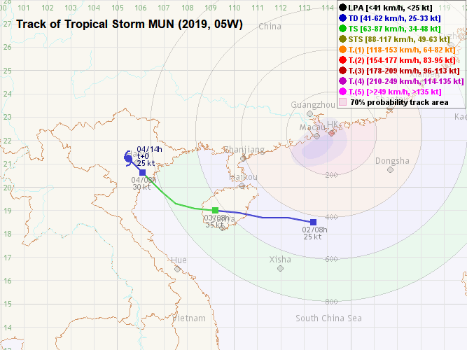
TC track from HKWW 本站的熱帶氣旋路徑圖:
TC track from HKO 天文台的熱帶氣旋路徑圖:
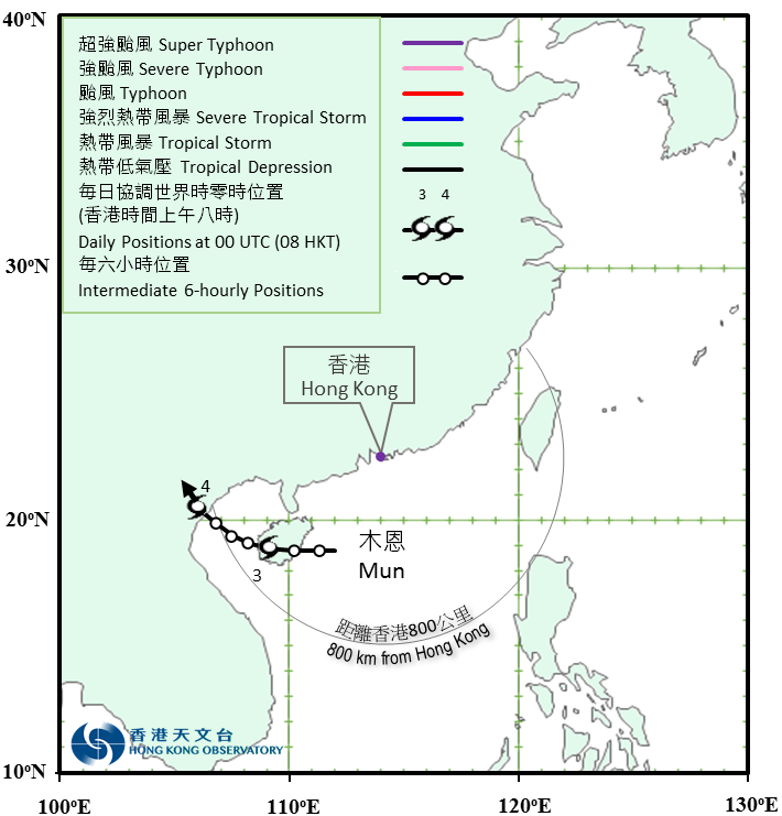
TC track with signal information 附有熱帶氣旋警告信號資料的路徑圖:
(Track figure courtesy of Lorenzo. Data from HKO. 鳴謝 Lorenzo 提供路徑圖,資料取自天文台)

| Past HKWW Bulletins 本站發佈 |
Please click here for bulletins on this tropical cyclone. 請按這裡。
| Storm Development Overview 風暴發展概覽 |
Unless otherwise stated, all times below are in Hong Kong Standard Time (UTC+8)
除非特別註明,下文時間均為香港標準時間 (協調世界時加 8 小時)
MUN developed as a broad monsoon depression within the South China Sea. Numerical models started to pick up this system in late June and the actual development of the disturbance (96W) began in early July. In the morning of July 1, the HKO issued a special weather alert on 96W's potential development, stating that it would most likely move towards Hainan Island and its associated rainbands would bring unstable weather to the territory. The JMA issued a gale warning that afternoon.
96W's spiraling cloud bands improved slightly on July 2, but its centre remained ill-defined from satellite images, a characteristic that is typical of a monsoon low. A wind field analysis that morning revealed patches of strong wind to the south and southeast of the low pressure area's centre, but winds near the centre were relatively light. The JTWC issued a tropical cyclone formation alert at 2 am July 2. As 96W's convective activities increased, the HKO upgraded it into a tropical depression after 4 pm that afternoon. 96W was under the influence of a weak ridge in China and the subtropical ridge in the Pacific Ocean. The storm was forecast to move west initially, followed by a turn to the northwest as the subtropical ridge would then extend towards the west into the South China Sea, contributing to 96W's northward track component.
Later that night, the JMA upgraded 96W into tropical storm status and named it MUN. Nevertheless, the wind field analysis that night did not suggest the existence of any gale force wind area in its vicinity. As predicted, MUN moved west and the NMC (China) reported that it had made landfall near Wanning, Hainan soon after midnight July 3 as a weak tropical storm.
MUN crossed Hainan in the small hours of July 3, still generally moving west. The JTWC finally upgraded it into tropical cyclone status and gave it the storm number 05W. MUN entered the Gulf of Tonkin near noon with strong convective patches near the centre, although heavily displaced to the west by the strong vertical wind shear. The storm turned northwest while crossing the Gulf and made a final landfall in the morning of July 4 in northern Vietnam. MUN's core degenerated quickly upon landfall, and the storm weakened into an area of low pressure near Hanoi soon after.
木恩的前身為於南海的一個廣闊季風低壓。數值模式早於六月下旬開始估計此系統的形成,而此擾動 (96W) 於 7 月初正式發展。7 月 1 日早上,香港天文台發佈特別天氣提示,表示 96W 將有所發展並將移至海南島一帶,與其相關的雨帶將為香港帶來不穩定的天氣。日本氣象廳則於當天下午發出烈風警報。
96W 的旋捲性於 2 日略為改善,但其中心位置仍然難以從雲圖辨識,這正是季風低壓的典型特徵。當天早上的風場掃描顯示該低壓區中心之南及東南方有強風區,但近中心處風速相對較低。聯合颱風警報中心於 2 日上午 2 時發出熱帶氣旋形成警報。隨著 96W 的對流活動增加,香港天文台於當天下午 4 時過後將其升格為熱帶低氣壓。96W 當時正受處於中國的一道弱高壓及於太平洋的副熱帶高壓脊影響,預料初時向偏西移動,隨後因副高西伸入南海而令其路徑出現偏北向量,屆時氣旋將轉西北移動。
2 日晚,日本氣象廳升格 96W 為熱帶風暴,並將其命名為木恩。可是,當晚的風場掃描顯示風暴附近並無烈風區。一如預期,木恩向西移動,中國中央氣象台表示木恩於 3 日午夜後不久登陸海南萬寧,強度為熱帶風暴下限。
木恩於 3 日凌晨橫過海南島,仍然大致向偏西移動。此時聯合颱風警報中心終於將木恩升格為熱帶氣旋,並給予風暴編號 05W。木恩於接近中午時份進入北部灣,其中心附近有強對流雲團,但明顯被強烈垂直風切變切離至西方。木恩於橫過北部灣時轉向西北移動,並於 4 日早上登陸越南北部。登陸後,木恩的中心快速解體,不久後風暴於河內附近減弱為低壓區。
| Weather in Hong Kong During Approach 風暴影響時香港天氣狀況 |
Link to relevant HKO weather report bulletins:
2/7 ●
3/7
香港天文台相關天氣報告連結:2/7 ●
3/7
Locally, the weather was rather unstable in late June. Affected by MUN's circulation, winds turned easterly in the afternoon of July 1 with a slight increase in the wind speed. A few stations such as Cheung Chau and Peng Chau registered brief periods of strong winds in the morning of July 2. The weather also turned overcast with some squally showers in the afternoon. The HKO issued the #1 Standby Signal at 4:15 pm, the same time as it upgraded MUN into a tropical depression, when MUN was around 440 km from Hong Kong.
Winds were mostly the strongest in the night of July 2; a few stations offshore and on high ground saw strong force winds, but winds in urban areas generally remained moderate. Persistent rainfall affected Hong Kong that night as MUN's rainbands swept across the territory. The Amber Rainstorm Warning was issued at 12:45 am July 3, and remained in force until 2:05 am.
As MUN moved away, the #1 Signal was cancelled at 5:40 am. The weather remained unstable throughout July 3, and improved gradually on July 4 with some sunny intervals.
本港方面,6 月底天氣不太穩定。受木恩的環流影響,本港於 7 月 1 日下午轉吹偏東風,風速稍為上升。部分氣象站如長洲及坪洲於 2 日早上短暫錄得強風,下午密雲及有幾陣狂風驟雨。天文台於下午 4 時 15 分升格木恩為熱帶低氣壓的同時發出一號戒備信號,當時風暴距離香港約 440 公里。
本港風勢普遍於 2 日晚最強,數個離岸及高地氣象站錄得強風,但市區風勢仍然和緩。隨著木恩的雨帶掃過香港,當晚雨勢持續,黃色暴雨警告曾於 3 日上午 12 時 45 分至上午 2 時 05 分期間生效。
隨著木恩遠離,一號戒備信號於上午 5 時 40 分取消。3 日餘下時間天氣仍然不穩定,至 4 日逐漸轉好,且短暫時間有陽光。
| Image Gallery 圖片庫 |

Figure 1 - Satellite image of MUN during its initial stages of formation
圖 1 - 木恩形成初期之衛星雲圖

Figure 2 - Steering flow chart at 8 am July 2
圖 2 - 7 月 2 日上午 8 時之駛流場圖


Figure 3 - Wind field analysis at 10:32 am July 2 (left) and 10:44 am July 3 (right)
圖 3 - 7 月 2 日上午 10 時 32 分 (左) 及 3 日上午 10 時 44 分 (右)之風場掃描圖

Figure 4 - JMA's initial forecast as it upgraded MUN into a tropical storm. Note MUN's extensive estimated 30-knot wind area.
圖 4 - 日本氣象廳升格木恩為熱帶風暴時之首佈預測,留意其估計 30 節風速區甚廣。

Figure 5 - MUN's rainbands affecting Hong Kong during the night of July 2-3
圖 5 - 木恩的雨帶於 7 月 2 至 3 日晚間影響香港

Figure 6 - Wind speed time series at Cheung Chau on July 2
圖 6 - 長洲於 7 月 2 日之風速時間序列圖

Figure 7 - Forecast tracks from various official agencies on July 3
圖 7 - 7 月 3 日各官方氣象台之預測路徑圖

Figure 8 - Satellite image of MUN at its peak intensity
圖 8 - 木恩於巔峰強度時之衛星雲圖
| Winds Recorded at Reference Stations 參考站所錄得的風速 |
Except for special cases, this section is not available for cyclones that only necessitated the Standby Signal. 除非特別情況,否則此部只當氣旋令天文台發出三號或更高信號時提供。
| Charts and Figures 各項數據 |
Table 1: Track data from HKWW:
表一 : 香港天氣觀測站之路徑資料
YYMMDDZZ Lat Long Wind |
Table 2: Maximum gust and hourly average wind speed recorded in Hong Kong from HKO:
表二 : 香港天文台公佈的各站最高每小時平均風力和陣風數據 (英文)
| Station | Maximum Gust | Maximum Hourly Mean Wind | ||||||
|---|---|---|---|---|---|---|---|---|
| Direction | Speed (km/h) |
Date/Month | Time | Direction | Speed (km/h) |
Date/Month | Time | |
| Bluff Head (Stanley) | S | 59 | 3/7 | 04:22 | E | 23 | 2/7 | 17:00 |
| Central Pier | E | 41 | 2/7 | 17:56 | ESE | 23 | 2/7 | 17:00 |
| Cheung Chau | ESE | 83 | 2/7 | 23:59 | E | 34 | 2/7 | 17:00 |
| Cheung Chau Beach | E | 72 | 2/7 | 23:59 | E | 38 | 2/7 | 17:00 |
| Green Island | SSE | 65 | 3/7 | 04:36 | ENE | 41 | 2/7 | 17:00 |
| ENE | 41 | 2/7 | 19:00 | |||||
| Hong Kong International Airport | ESE | 43 | 2/7 | 17:16 | E | 31 | 2/7 | 17:00 |
| Kai Tak | ESE | 47 | 2/7 | 21:43 | E | 22 | 2/7 | 17:00 |
| King's Park | E | 41 | 2/7 | 21:47 | E | 16 | 2/7 | 17:00 |
| Lamma Island | ESE | 47 | 3/7 | 04:28 | E | 25 | 2/7 | 17:00 |
| Lau Fau Shan | ENE | 41 | 2/7 | 19:10 | ENE | 25 | 2/7 | 20:00 |
| North Point | E | 45 | 2/7 | 21:42 | E | 22 | 2/7 | 17:00 |
| Peng Chau | E | 47 | 2/7 | 16:25 | E | 34 | 2/7 | 18:00 |
| Ping Chau | SE | 25 | 2/7 | 22:15 | E | 9 | 2/7 | 22:00 |
| Sai Kung | SE | 47 | 2/7 | 21:52 | ENE | 13 | 2/7 | 19:00 |
| Sha Chau | SE | 56 | 3/7 | 00:28 | SE | 31 | 2/7 | 18:00 |
| Sha Lo Wan | ENE | 47 | 2/7 | 17:04 | E | 20 | 2/7 | 17:00 |
| Sha Tin | ESE | 51 | 3/7 | 04:55 | E | 12 | 2/7 | 17:00 |
| Shek Kong | E | 40 | 2/7 | 19:39 | E | 23 | 2/7 | 18:00 |
| Star Ferry (Kowloon) | E | 43 | 2/7 | 21:44 | E | 22 | 2/7 | 17:00 |
| Ta Kwu Ling | ESE | 41 | 2/7 | 17:08 | E | 20 | 2/7 | 18:00 |
| Tai Mei Tuk | E | 56 | 2/7 | 22:11 | ENE | 27 | 2/7 | 20:00 |
| Tai Mo Shan | ESE | 81 | 2/7 | 16:15 | E | 62 | 2/7 | 17:00 |
| E | 81 | 2/7 | 16:53 | |||||
| Tai Po Kau | ESE | 54 | 2/7 | 22:14 | E | 22 | 2/7 | 17:00 |
| Tap Mun East | ESE | 56 | 2/7 | 21:57 | ESE | 40 | 2/7 | 17:00 |
| Tate's Cairn | S | 70 | 3/7 | 04:46 | E | 36 | 2/7 | 17:00 |
| Tseung Kwan O | SW | 47 | 3/7 | 04:43 | N | 9 | 2/7 | 19:00 |
| Tsing Yi Shell Oil Depot | E | 45 | 2/7 | 22:02 | ESE | 14 | 2/7 | 18:00 |
| E | 14 | 2/7 | 19:00 | |||||
| E | 14 | 3/7 | 01:00 | |||||
| Tuen Mun Government Offices | SSE | 43 | 3/7 | 00:27 | SSE | 12 | 2/7 | 23:00 |
| Waglan Island | S | 72 | 3/7 | 04:26 | E | 45 | 2/7 | 17:00 |
| Wetland Park | SE | 27 | 2/7 | 16:55 | ESE | 13 | 2/7 | 17:00 |
| Wong Chuk Hang | W | 45 | 3/7 | 04:31 | E | 19 | 2/7 | 17:00 |
Table 3: Rainfall (in millimetres) contributed by MUN from HKO (figures in brackets are based on incomplete hourly data):
表三 : 香港天文台公佈的各站雨量資料 (英文) (方括號內之數據由不完整之每小時資料擷取)
| Station | 2-Jul | 3-Jul | Total Rainfall (mm) |
|
|---|---|---|---|---|
| Hong Kong Observatory (HKO) | 19.1 | 79.1 | 98.2 | |
| Hong Kong International Airport (HKA) | 19.4 | 86.8 | 106.2 | |
| Cheung Chau (CCH) | 25.0 | 59.5 | 84.5 | |
| H23 | Aberdeen | 26.5 | 69.0 | 95.5 |
| N05 | Fanling | 5.0 | 55.0 | 60.0 |
| N13 | High Island | 16.5 | 72.0 | 88.5 |
| K04 | Jordan Valley | 31.5 | 97.0 | 128.5 |
| N06 | Kwai Chung | 15.5 | 78.0 | 93.5 |
| H12 | Mid Levels | 24.5 | 71.5 | 96.0 |
| N09 | Sha Tin | 15.0 | 93.0 | 108.0 |
| H19 | Shau Kei Wan | 36.5 | 102.5 | 139.0 |
| SEK | Shek Kong | 4.5 | 58.5 | 63.0 |
| K06 | So Uk Estate | 19.5 | 75.5 | 95.0 |
| R31 | Tai Mei Tuk | 10.0 | 95.0 | 105.0 |
| R21 | Tap Shek Kok | [10.0] | [94.5] | [104.5] |
| N17 | Tung Chung | 31.5 | 128.0 | 159.5 |
| TMR | Tuen Mun Reservoir | 10.5 | 88.3 | 98.8 |
Last Accessed 最近訪問日期: Sat Apr 20 2024 08:07:26 HKT
Last Modified 最近修訂日期: Mon Jul 24 2023
