
TC Watch / 熱帶氣旋 > Selected TC Review / 重要熱帶氣旋回顧 > 202019W (SAUDEL 沙德爾) [Refresh 更新]
 202019W (SAUDEL 沙德爾) - Profile 檔案 202019W (SAUDEL 沙德爾) - Profile 檔案 |
(First draft issued on October 30, 2020; final version issued on January 7, 2021)
(初稿於 2020 年 10 月 30 日發出,最後版本於 2021 年 1 月 7 日上載)
Brief profile of SAUDEL | 沙德爾小檔案:
| JTWC number 聯合颱風警報中心 (JTWC) 號碼 | 19W |
| International number 國際編號 | 2017 |
| Period of existence 生存時期 (JTWC) | 2020/10/19 08 HKT - 2020/10/26 02 HKT |
| Lifetime 壽命 (JTWC) | 6.75 days 日 |
| Maximum 1-minute wind (JTWC) JTWC 一分鐘平均最高中心風速 | 80 knots 節 (Category 1 Typhoon 一級颱風) |
| Minimum pressure (JTWC) JTWC 最低氣壓 | 972 hPa 百帕 |
| Highest TC signal by HKO 香港天文台發出最高熱帶氣旋警告信號 |
3 (Strong Wind Signal 強風信號) |
| Closest point of approach by HKO 香港天文台所示之最接近距離 |
S 490 km (real-time warning and TC report 實時報告及熱帶氣旋報告) |
| Time of closest approach by HKO 香港天文台所示之最接近時間 |
2020/10/23 20 HKT (real-time warning and TC report 實時報告及熱帶氣旋報告) |
| Lowest pressure recorded at HKO 香港天文台錄得的最低氣壓 |
1009.1 hPa 百帕 (2020/10/22 17:40 HKT) |
TC signals in Hong Kong* 香港曾經生效的熱帶氣旋警告*:
| Signal 信號 |
Date and time 日期和時間 |
Distance from HK 與香港的距離 |
Predicted movement 預測移動趨勢 |
Max. 10-min winds 中心最高十分鐘平均風速 |
 |
2020/10/22 (THU) 17:40 HKT | SSE 590 km | NW slowly | 120 km/h (65 knots, T) |
 |
2020/10/23 (FRI) 00:20 HKT | SSE 570 km | NW slowly | 120 km/h (65 knots, T) |
 |
2020/10/24 (SAT) 09:10 HKT** | SSW 500 km | W at 12 km/h | 105 km/h (55 knots, STS) |
*Based on the information from real-time tropical cyclone warning bulletins.
*根據實時熱帶氣旋警報資料。
**The Strong Monsoon Signal was issued 1 minute after the #3 Strong Wind Signal was cancelled.
**強烈季候風信號於三號強風信號取消後一分鐘發出。
Percentile rank among storms with #3 Signal (at compilation of this review)*: *This measures the relative wind strength in Hong Kong caused by this storm compared with others that share the same signal. 指標顯示此風暴相對於其他發出同樣信號的風暴為香港帶來之風力強度 For more information, please refer to Wind Speed Data for TCs that Have Affected Hong Kong. 更多資訊載於 影響香港氣旋之風速數據 頁 |
Overall: 總計: |
|
Weak 弱 |
|||
| Component Ranks 分部等級 | ||||||
| Reference stations: 參考站: |
|
Weak 弱 |
||||
| Victoria Harbour: 維多利亞港: |
|
Weak 弱 |
||||
| Urban: 市區: |
|
Weak 弱 |
||||
| Offshore & high ground 離岸和高地: |
|
Weak 弱 |
||||
Cyclones that attained similar rating (with signal #3): YUTU (2018), TALIM (2012), MARIAN (1990) 相近級別之熱帶氣旋 (三號信號):玉兔 (2018)、泰利 (2012)、瑪麗安 (1990) |
||||||
IR imagery animation 紅外線雲圖動畫:
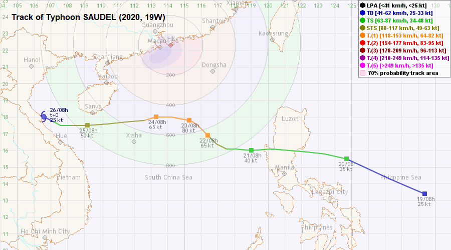
TC track from HKWW 本站的熱帶氣旋路徑圖:
TC track from HKO 天文台的熱帶氣旋路徑圖:
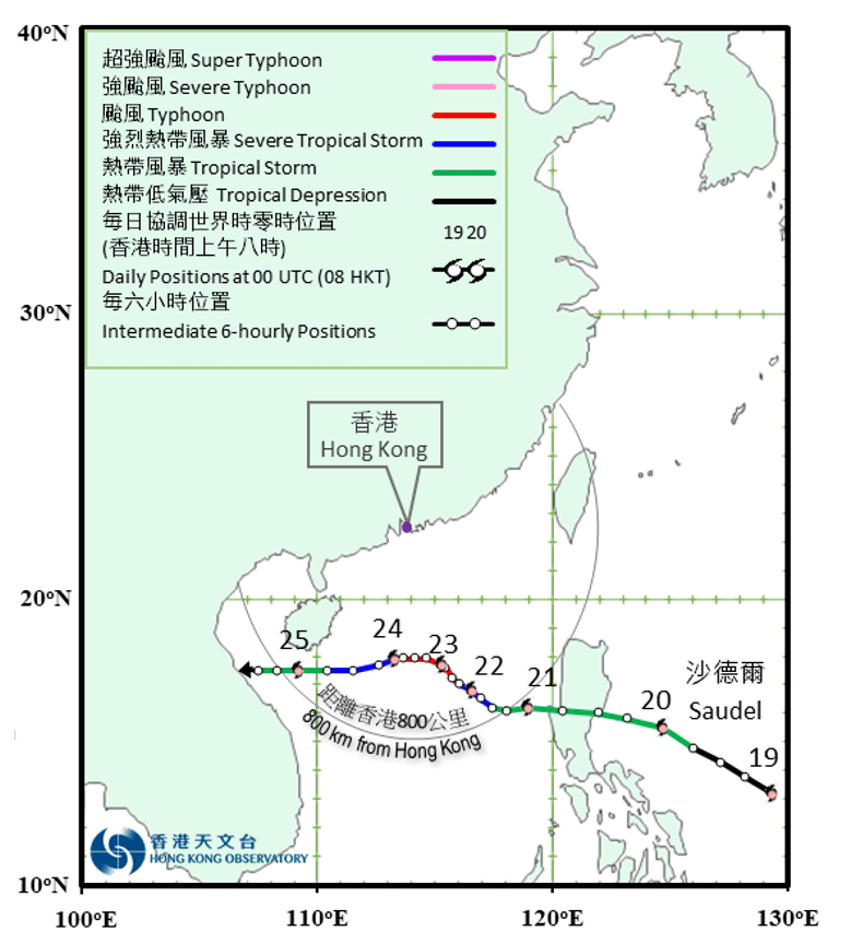
TC track with signal information 附有熱帶氣旋警告信號資料的路徑圖:
(Track figure courtesy of Lorenzo. Data from HKO. 鳴謝 Lorenzo 提供路徑圖,資料取自天文台)

| Past HKWW Bulletins 本站發佈 |
Please click here for bulletins on this tropical cyclone. 請按這裡。
| Storm Development Overview 風暴發展概覽 |
Unless otherwise stated, all times below are in Hong Kong Standard Time (UTC+8)
除非特別註明,下文時間均為香港標準時間 (協調世界時加 8 小時)
SAUDEL was developed from tropical disturbance 96W in the northwest Pacific. The JTWC upgraded it into tropical depression 19W and issued the first bulletin in the morning of October 19, while the JMA issued a gale warning for the system at the same time. 19W was travelling west-northwest along the southwestern periphery of the subtropical ridge. It was expected to turn west gradually and impact Luzon.
19W showed signs of intensification on October 20, but the vertical wind shear was keeping convections from developing in the eastern semicircle. The JMA, JTWC and HKO upgraded 19W into tropical storm that morning, with the JMA naming the storm SAUDEL. SAUDEL made landfall at Luzon at around 9 pm that night; most of the deep convections had already been displaced into the South China Sea in the small hours of October 21. SAUDEL's centre entered the Sea soon after, and the storm moved west with irregular jogs as it reorganized itself in the rest of the day. The subtropical ridge north of SAUDEL started to weaken at that time and SAUDEL decelerated as a result.
Following a decrease in the level of vertical wind shear, SAUDEL picked up strength on October 21. The JMA upgraded it into a severe tropical storm in the afternoon, while the HKO made the upgrade that night. Tight convective bands developed in SAUDEL's southern periphery. As the subtropical ridge weakened, SAUDEL turned northwest on October 22 and moved into the pressure col. It further intensified into a typhoon that day.
SAUDEL remained slow-moving and started to turn west in the morning of October 23, as the subtropical ridge redeveloped in southern China. The storm accelerated towards the seas south of Hainan Island but started to weaken at the same time due to cooler sea temperatures and the intrusion of dry air from the northeast monsoon. The HKO downgraded SAUDEL into a severe tropical storm in the morning of October 24, and further into a tropical storm near midday of October 25. The storm quickly lost its deep convections as it approached the Vietnamese coast, and weakened into a tropical depression before it reached land.
SAUDEL made its final landfall in central Vietnam on October 26. There is some variance on the exact time of landfall, because SAUDEL had become very disorganized by then. The remnants of SAUDEL dissipated soon afterwards.
沙德爾是由位於西北太平洋的熱帶擾動 96W 發展而成。聯合颱風警報中心於 10 月 19 日早上將其升格為熱帶低氣壓 19W,而同時日本氣象廳發佈烈風警告。19W 當時沿副熱帶高壓脊西南部向西北偏西移動,預料會轉西移並影響呂宋。
19W 於 20 日有跡象增強,但垂直風切變令對流難以於風暴東半圓發展。日本氣象廳、聯合颱風警報中心及香港天文台均於當天早上升格 19W 為熱帶風暴,而日本氣象廳將其命名為沙德爾。沙德爾於當天下午約 9 時登陸呂宋,至 21 日凌晨大部分深層對流已被切離至南海。風暴中心不久後亦進入南海,而風暴於 21 日餘下時間重新組織,期間大致西移但間中移動不規則。隨著沙德爾以北的副熱帶高壓脊開始減弱,風暴亦有所減速。
垂直風切變水平下降令沙德爾於 21 日逐漸增強。日本氣象廳於下午將其升格為強烈熱帶風暴,而香港天文台則於當晚升格。沙德爾的南面發展出緊密的對流雲帶。由於副熱帶高壓脊減弱,沙德爾於 22 日轉向西北移動,進入鞍場,並於當天增強為颱風。
沙德爾移速繼續緩慢,並於 23 日早上因副熱帶高壓脊於華南再度發展而開始向西移動。風暴加速並移向海南島以南一帶,但由於該區海溫較低,加上受東北季候風所帶來的較乾氣流入侵,沙德爾逐漸減弱。香港天文台於 24 日早上將沙德爾降格為強烈熱帶風暴,並於 25 日近中午進一步降格為熱帶風暴。風暴靠近越南沿岸時快速失去其深層對流,並於登陸前減弱為熱帶低氣壓。
沙德爾於 26 日於越南中部作最後一次登陸。由於其結構已經非常散亂,其登陸時間未能確定,而沙德爾的殘餘於不久後消散。
| Weather in Hong Kong During Approach 風暴影響時香港天氣狀況 |
Link to relevant HKO weather report bulletins:
22/10 ●
23/10 ●
24/10
香港天文台相關天氣報告連結:22/10 ●
23/10 ●
24/10
It was mainly sunny in Hong Kong on October 21, and there were sunny periods on October 22. As SAUDEL turned northwest on October 22, and due to the combined effect of SAUDEL and the northeast monsoon, winds were rather strong that day, blowing in from the north. Winds at Waglan Island were persistently at the strong force level in the morning. The HKO issued the #1 Standby Signal at 5:40 pm October 22, when SAUDEL was situated about 590 km south-southeast of Hong Kong. It was indicated that the chances of upgrading the signal before midnight were low as SAUDEL was expected to maintain a distance of over 500 km from the territory.
While winds strengthened at some locations such as Green Island and Ngong Ping that night, a number of places actually saw a significant drop in wind speed. In fact, it turned out that 3 of the 8 reference stations had the strongest winds during SAUDEL's approach recorded before the issuance of the #1 Signal. Nevertheless, as SAUDEL was expected to move somewhat closer to Hong Kong on October 23, the HKO mentioned at 9 pm that the #3 Signal would be issued after midnight.
Shortly after midnight, the #3 Strong Wind Signal was issued at 12:20 am October 23, less than 7 hours after the issuance of the #1 Signal. SAUDEL was about 570 km from Hong Kong at that time. Throughout the day, local winds were predominantly northerly with little change in intensity. Sustained strong force winds were recorded in offshore waters and on high ground, and the HKO mentioned that gales were affecting northeastern South China Sea. While the skies turned cloudy on October 23, there was no rain.
SAUDEL was closest to Hong Kong at around 8 pm October 23, when it was around 490 km south of the territory. After that, SAUDEL moved west and did not gain latitude anymore. The wind direction turned northeast early on October 24 but the winds were no stronger than on the previous day. As SAUDEL further receded, the HKO cancelled the #3 Signal at 9:10 am and issued the Strong Monsoon Signal one minute later. Strong winds continued to affect offshore areas and high ground in the rest of October 24, and SAUDEL's outermost rainband brought light rain to the territory in the morning. The Strong Monsoon Signal remained in force until 1 pm October 25.
香港方面,10 月 21 日大致天晴,22 日部分時間有陽光。隨著沙德爾於 22 日轉向西北移動,並受沙德爾及東北季候風的共同影響,當天主要吹北風,風勢頗大。橫欄島當天上午持續吹強風。天文台於 22 日下午 5 時 40 分發出一號戒備信號,當時沙德爾位於香港東南偏南約 590 公里。由於預料沙德爾會與香港維持超過 500 公里的距離,天文台表示午夜前改發更高信號較低。
雖然部分地區如青洲及昂坪當晚風勢有所增強,但亦有部分地區風勢明顯下降。在 8 個參考測風站中,有 3 個於一號信號發出前已錄得風暴靠近期間的最高風速。雖然風勢未有大幅改變,但由於預料沙德爾會於 23 日稍為接近香港,天文台於下午 9 時提及會於當晚午夜過後發出三號信號。
午夜後不久,三號強風信號於 23 日上午 12 時 20 分發出,距離一號信號發出時間不足 7 小時,而沙德爾距港約 570 公里。當天本港大致吹北風,風勢仍然沒甚變化。離岸及高地錄得持續風速達強風水平,天文台表示烈風影響南海東北部。雖然 23 日天色轉為多雲,但並無降雨。
沙德爾於 23 日下午約 8 時最接近香港,於南方約 490 公里處掠過。此後,沙德爾向西移動,其緯度再無增加。24 日早段風向轉為東北,但風勢仍然沒有增強。隨著沙德爾移離,天文台於上午 9 時 10 分取消三號信號,一分鐘後發出強烈季候風信號。強風繼續於 24 日餘下時間影響離岸及高地,而沙德爾的最外圍雨帶於當早為香港帶來微雨。強烈季候風信號當天維持,直至 25 日下午 1 時才取消。
| Image Gallery 圖片庫 |

Figure 1 - Satellite image of SAUDEL at 2 pm October 20
圖 1 - 10 月 20 日下午 2 時沙德爾之衛星雲圖
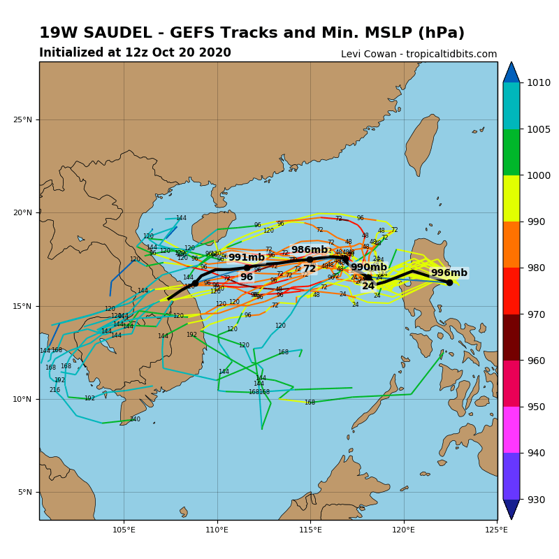
Figure 2 - GFS ensemble forecast tracks at 8 pm October 20; note the wide spread in the forecast tracks (Image from tropicaltidbits)
圖 2 - 10 月 20 日下午 8 時 GFS 模式集成預測路徑圖,留意路徑分歧頗大 (圖像由 tropicaltidbits 網站擷取)
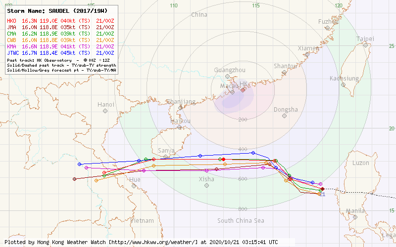
Figure 3 - Forecast tracks from various official agencies at 8 am October 21
圖 3 - 10 月 21 日上午 8 時各官方氣象台之預測路徑圖

Figure 4 - Steering flow chart at 8 am October 22
圖 4 - 10 月 22 日上午 8 時之駛流場圖
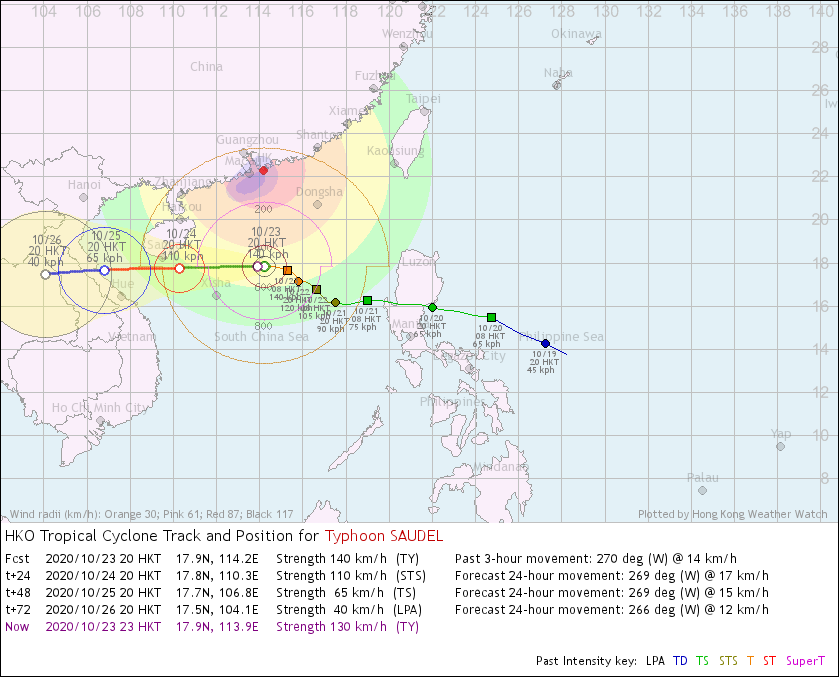
Figure 5 - HKO's forecast track and estimated wind fields at 8 pm October 23
圖 5 - 10 月 23 日下午 8 時香港天文台之路徑及估算風場圖
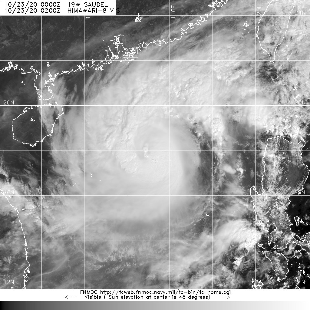
Figure 6 - Satellite image of SAUDEL at peak intensity
圖 6 - 沙德爾於巔峰強度時之衛星雲圖

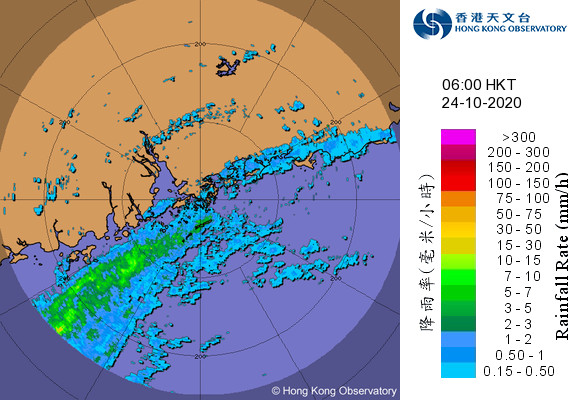
Figure 7 - Radar images at 1 pm October 23 (left) and 6 am October 24 (right)
圖 7 - 10 月 23 日下午 1 時 (左) 及 24 日上午 6 時 (右) 之雷達圖


Figure 8 - Wind speed time series at Waglan Island on October 22-23
圖 8 - 橫瀾島於 10 月 22-23 日之風速時間序列圖

Figure 9 - Satellite image of SAUDEL as it crossed the seas south of Hainan Island
圖 9 - 沙德爾橫過海南島以南海域時之衛星雲圖
| Winds Recorded at Reference Stations 參考站所錄得的風速 |
The following table lists the maximum 10-minute average (sustained) wind speed recorded while tropical cyclone signals were in force. In some occasions, it is possible that the strongest winds were not recorded when the highest signal was in force.
下表列出各站於熱帶氣旋警告信號生效時所錄得的最高 10 分鐘平均 (持續) 風速,留意此風速不一定於最高信號生效期間錄得。
| Station 風速站 |
Max. 10-min avg. wind speed 最高十分鐘平均風速 |
Beaufort classification 蒲福氏風級分類 |
| Chek Lap Kok 赤鱲角 | 32 km/h | Fresh 清勁 |
| Cheung Chau 長洲 | 42 km/h* | STRONG 強風 |
| Kai Tak 啟德 | 22 km/h | Moderate 和緩 |
| Lau Fau Shan 流浮山 | 41 km/h | STRONG 強風 |
| Sai Kung 西貢 | 37 km/h** | Fresh 清勁 |
| Sha Tin 沙田 | 22 km/h | Moderate 和緩 |
| Ta Kwu Ling 打鼓嶺 | 26 km/h*** | Moderate 和緩 |
| Tsing Yi (SHL) 青衣蜆殼油庫 | 22 km/h | Moderate 和緩 |
*A sustained wind speed of 48 km/h (strong force) was recorded at Cheung Chau near 4:30 pm October 22, before the issuance of the #1 Signal.
*一號信號發出前,長洲曾於 10 月 22 日下午約 4 時 30 分錄得持續風速每小時 48 公里 (強風)。
**A sustained wind speed of 44 km/h (strong force) was recorded at Sai Kung near 4 pm October 22, before the issuance of the #1 Signal.
**一號信號發出前,西貢曾於 10 月 22 日下午約 4 時錄得持續風速每小時 44 公里 (強風)。
***A sustained wind speed of 29 km/h was recorded at Ta Kwu Ling near 1:10 pm October 22, before the issuance of the #1 Signal.
**一號信號發出前,打鼓嶺曾於 10 月 22 日下午約 1 時 10 分錄得持續風速每小時 29 公里。
| Number of stations recording at least STRONG force (force 6 - 7) winds: | 2 |
| Number of stations recording at least GALE force (force 8 - 9) winds: | 0 |
| Number of stations recording at least STORM force (force 10 - 11) winds: | 0 |
| Number of stations recording HURRICANE force (force 12) winds: | 0 |
| 錄得 強風 (6 - 7 級) 或更高風速的站數: | 2 |
| 錄得 烈風 (8 - 9 級) 或更高風速的站數: | 0 |
| 錄得 暴風 (10 - 11 級) 或更高風速的站數: | 0 |
| 錄得 颶風 (12 級) 風速的站數: | 0 |
| Charts and Figures 各項數據 |
Table 1: Track data from HKWW:
表一 : 香港天氣觀測站之路徑資料
YYMMDDZZ Lat Long Wind |
Table 2: Maximum gust and hourly average wind speed recorded in Hong Kong from HKO:
表二 : 香港天文台公佈的各站最高每小時平均風力和陣風數據 (英文)
Maximum Gust |
Maximum Hourly Mean Wind |
|||||||
|---|---|---|---|---|---|---|---|---|
| Direction |
Speed (km/h) |
Date/Month |
Time |
Direction |
Speed (km/h) |
Date/Month |
Time |
|
| Bluff Head (Stanley) | NNE | 47 | 22/10 | 23:15 | ENE | 17 | 24/10 | 03:00 |
| Central Pier | NE | 50 | 22/10 | 21:17 | NE | 24 | 23/10 | 09:00 |
| Cheung Chau | NNE | 59 | 22/10 | 19:54 | N | 39 | 22/10 | 20:00 |
| Cheung Chau Beach | NE | 55 | 23/10 | 06:55 | NNE | 30 | 22/10 | 20:00 |
| Green Island | NNE | 76 | 22/10 | 20:56 | NNE | 53 | 22/10 | 21:00 |
| Hong Kong International Airport | NE | 46 | 23/10 | 00:45 | NNE | 25 | 23/10 | 01:00 |
| NNE | 25 | 23/10 | 08:00 | |||||
| NNE | 25 | 23/10 | 09:00 | |||||
| Kai Tak | N | 45 | 22/10 | 18:40 | N | 15 | 22/10 | 19:00 |
| King's Park | NNE | 55 | 22/10 | 20:34 | N | 21 | 23/10 | 07:00 |
| N | 21 | 23/10 | 08:00 | |||||
| N | 21 | 23/10 | 10:00 | |||||
| Lamma Island | N | 46 | 22/10 | 20:26 | N | 20 | 23/10 | 00:00 |
| Lau Fau Shan | N | 58 | 23/10 | 10:29 | N | 33 | 23/10 | 11:00 |
| Ngong Ping | ENE | 77 | 22/10 | 20:43 | ENE | 53 | 22/10 | 21:00 |
| North Point | NNE | 50 | 22/10 | 19:36 | NNE | 22 | 22/10 | 21:00 |
| Peng Chau | NNE | 57 | 22/10 | 18:38 | NNE | 33 | 22/10 | 20:00 |
| Ping Chau | NNE | 35 | 22/10 | 19:20 | N | 8 | 22/10 | 20:00 |
| Sai Kung | NNE | 56 | 22/10 | 19:15 | NNE | 36 | 22/10 | 18:00 |
| Sha Chau | N | 60 | 22/10 | 18:02 | N | 43 | 22/10 | 19:00 |
| Sha Lo Wan | ENE | 41 | 22/10 | 23:12 | ENE | 18 | 23/10 | 00:00 |
| Sha Tin | NNE | 46 | 22/10 | 22:03 | NE | 19 | 22/10 | 21:00 |
| Star Ferry (Kowloon) | SE | 33 | 22/10 | 19:30 | E | 9 | 24/10 | 02:00 |
| Ta Kwu Ling | NNE | 49 | 23/10 | 08:17 | NNE | 21 | 23/10 | 07:00 |
| NNE | 21 | 23/10 | 08:00 | |||||
| Tai Mei Tuk | NE | 66 | 22/10 | 20:05 | NE | 37 | 22/10 | 21:00 |
| Tai Mo Shan | ENE | 83 | 23/10 | 19:18 | ENE | 66 | 23/10 | 08:00 |
| Tai Po Kau | NNE | 40 | 22/10 | 19:22 | NNE | 14 | 23/10 | 09:00 |
| Tap Mun East | N | 48 | 22/10 | 18:15 | N | 23 | 22/10 | 18:00 |
| Tate's Cairn | NE | 88 | 22/10 | 19:35 | NNE | 66 | 22/10 | 21:00 |
| Tseung Kwan O | NNE | 46 | 22/10 | 21:12 | NNE | 14 | 22/10 | 21:00 |
| Tsing Yi Shell Oil Depot | NNW | 43 | 22/10 | 19:11 | NNW | 16 | 22/10 | 23:00 |
| Tuen Mun Government Offices | NNE | 49 | 22/10 | 21:11 | NNE | 19 | 22/10 | 22:00 |
| NNE | 49 | 22/10 | 21:42 | |||||
| NNE | 49 | 23/10 | 00:24 | |||||
| Waglan Island | N | 58 | 22/10 | 18:50 | N | 48 | 22/10 | 20:00 |
| Wetland Park | NE | 38 | 23/10 | 08:19 | NNE | 14 | 23/10 | 09:00 |
| Wong Chuk Hang | N | 51 | 22/10 | 20:27 | NNW | 14 | 22/10 | 21:00 |
Table 3: Rainfall (in millimetres) contributed by SAUDEL from HKO (figures in brackets are based on incomplete hourly data):
表三 : 香港天文台公佈的各站雨量資料 (英文) (方括號內之數據由不完整之每小時資料擷取)
| 22-Oct |
23-Oct |
24-Oct |
Total Rainfall (mm) |
||
|---|---|---|---|---|---|
| Hong Kong Observatory (HKO) | 0.0 |
0.0 |
Trace |
Trace |
|
| Hong Kong International Airport (HKA) | 0.0 |
0.0 |
Trace |
Trace |
|
| Cheung Chau (CCH) | 0.0 |
0.0 |
0.0 |
0.0 |
|
| H23 | Aberdeen | 0.0 |
0.0 |
0.0 |
0.0 |
| N05 | Fanling | 0.0 |
0.0 |
0.0 |
0.0 |
| N13 | High Island | 0.0 |
0.0 |
0.0 |
0.0 |
| K04 | Jordan Valley | 0.0 |
0.0 |
0.0 |
0.0 |
| N06 | Kwai Chung | 0.0 |
0.0 |
0.0 |
0.0 |
| H12 | Mid Levels | 0.0 |
0.0 |
0.0 |
0.0 |
| N09 | Sha Tin | 0.0 |
0.0 |
0.0 |
0.0 |
| H19 | Shau Kei Wan | 0.0 |
0.0 |
0.0 |
0.0 |
| SEK | Shek Kong | 0.0 |
0.0 |
0.0 |
0.0 |
| K06 | So Uk Estate | 0.0 |
0.0 |
0.0 |
0.0 |
| R31 | Tai Mei Tuk | 0.0 |
0.0 |
0.0 |
0.0 |
| R21 | Tap Shek Kok | 0.0 |
0.0 |
[0.0] |
[0.0] |
| N17 | Tung Chung | 0.0 |
0.0 |
0.0 |
0.0 |
| TMR | Tuen Mun Reservoir | 0.0 |
0.0 |
0.0 |
0.0 |
Last Accessed 最近訪問日期: Sat Apr 20 2024 00:23:18 HKT
Last Modified 最近修訂日期: Mon Jul 24 2023
