
TC Watch / 熱帶氣旋 > Selected TC Review / 重要熱帶氣旋回顧 > 202110W (CEMPAKA 查帕卡) [Refresh 更新]
 202110W (CEMPAKA 查帕卡) - Profile 檔案 202110W (CEMPAKA 查帕卡) - Profile 檔案 |
(First draft issued on August 1, 2021; final version issued on September 26, 2021)
(初稿於 2021 年 8 月 1 日發出,最後版本於 2021 年 9 月 26 日上載)
Brief profile of CEMPAKA | 查帕卡小檔案:
| JTWC number 聯合颱風警報中心 (JTWC) 號碼 | 10W |
| International number 國際編號 | 2107 |
| Period of existence 生存時期^ | 2021/07/18 23 HKT - 2021/07/24 20 HKT |
| Maximum 1-minute wind (JTWC) JTWC 一分鐘平均最高中心風速 | 80 knots 節 (Category 1 Typhoon 一級颱風) |
| Minimum pressure (JTWC) JTWC 最低氣壓 | 970 hPa 百帕 |
| Highest TC signal by HKO 香港天文台發出最高熱帶氣旋警告信號 |
3 (Strong Wind Signal 強風信號) |
| Closest point of approach by HKO 香港天文台所示之最接近距離 |
SSW 170 km (real-time warning 實時報告) / 180 km (TC report 熱帶氣旋報告) |
| Time of closest approach by HKO 香港天文台所示之最接近時間 |
2021/07/18 22 HKT (real-time warning and TC report 實時報告及熱帶氣旋報告) |
| Lowest pressure recorded at HKO 香港天文台錄得的最低氣壓 |
1001.2 hPa 百帕 (2021/07/19 16:09 HKT) |
^Refers to the period between the HK Observatory's first and last bulletins for the tropical cyclone (with at least tropical depression intensity). For storms formed/dissipated/transformed into an extratropical cyclone outside the area bounded by 7-36°N and 100-140°E, information from the JTWC will be used instead.
^即香港天文台為該熱帶氣旋 (熱帶低氣壓級或更高) 作出發佈的時期。至於在北緯 7 至 36 度、東經 100 至 140 度外形成/消散/轉化為溫帶氣旋的風暴,本網將參考聯合颱風警報中心的資料。
TC signals in Hong Kong* 香港曾經生效的熱帶氣旋警告*:
| Signal 信號 |
Date and time 日期和時間 |
Distance from HK 與香港的距離 |
Predicted movement 預測移動趨勢 |
Max. 10-min winds 中心最高十分鐘平均風速 |
 |
2021/07/18 (SUN) 21:40 HKT | SSW 170 km | W/WNW slowly | 45 km/h (25 knots, TD) |
 |
2021/07/19 (MON) 16:10 HKT | SW 180 km | N slowly | 75 km/h (40 knots, TS) |
|
2021/07/20 (TUE) 13:20 HKT | WSW 210 km | NW/NNW slowly | 120 km/h (65 knots, T) |
 |
2021/07/20 (TUE) 19:40 HKT | WSW 220 km | WNW slowly | 120 km/h (65 knots, T) |
*Based on the information from real-time tropical cyclone warning bulletins.
*根據實時熱帶氣旋警報資料。
Percentile rank among storms with #3 Signal (at compilation of this review)*: *This measures the relative wind strength in Hong Kong caused by this storm compared with others that share the same signal. 指標顯示此風暴相對於其他發出同樣信號的風暴為香港帶來之風力強度 For more information, please refer to Wind Speed Data for TCs that Have Affected Hong Kong. 更多資訊載於 影響香港氣旋之風速數據 頁 |
Overall: 總計: |
|
Weak 弱 |
|||
| Component Ranks 分部等級 | ||||||
| Reference stations: 參考站: |
|
Weak 弱 |
||||
| Victoria Harbour: 維多利亞港: |
|
Weak 弱 |
||||
| Urban: 市區: |
|
Weak 弱 |
||||
| Offshore & high ground 離岸和高地: |
|
Weak 弱 |
||||
Cyclones that attained similar rating (with signal #3): BEBINCA (2018), EWINIAR (2018), MAWAR (2017), NALGAE (2011), NANGKA (2009), DAN (1999), PENNY (1998) 相近級別之熱帶氣旋 (三號信號):貝碧嘉 (2018)、艾雲尼 (2018)、瑪娃 (2017)、尼格 (2011)、浪卡 (2009)、丹尼 (1999)、彭妮 (1998) |
||||||
IR imagery animation 紅外線雲圖動畫:
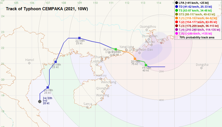
TC track from HKWW 本站的熱帶氣旋路徑圖:
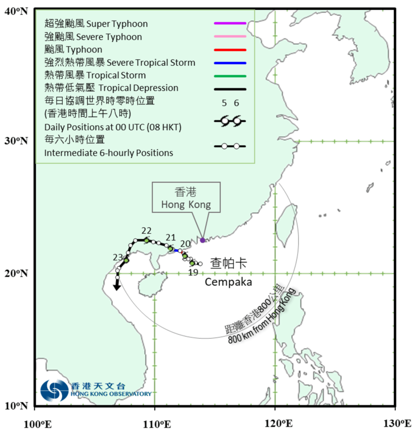
TC track from HKO 天文台的熱帶氣旋路徑圖:
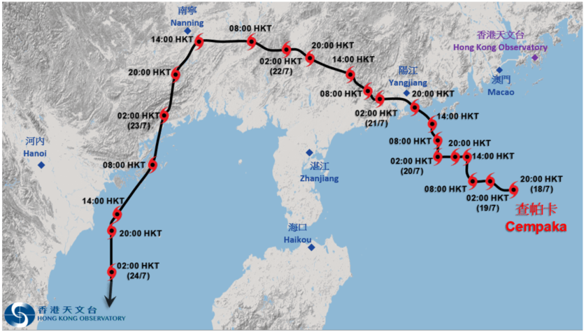
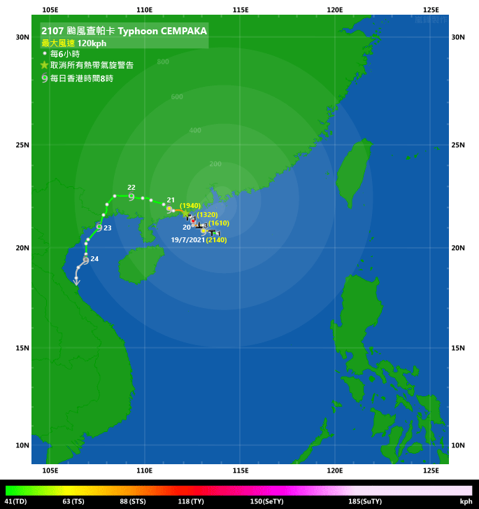
TC track with signal information 附有熱帶氣旋警告信號資料的路徑圖:
(Track figure courtesy of Lorenzo. Data from HKO. 鳴謝 Lorenzo 提供路徑圖,資料取自天文台)
| Past HKWW Bulletins 本站發佈 |
Please click here for bulletins on this tropical cyclone. 請按這裡。
| Storm Development Overview 風暴發展概覽 |
Unless otherwise stated, all times below are in Hong Kong Standard Time (UTC+8)
除非特別註明,下文時間均為香港標準時間 (協調世界時加 8 小時)
CEMPAKA developed as tropical disturbance 99W in the South China Sea. Initially in the eastern part of the Sea, 99W drifted westwards and started to gather convections on July 17. The HKO described it as a "broad area of low pressure" that brought showers and thunderstorms to coastal Guangdong. 99W grew in size early on July 18; the JTWC issued a tropical cyclone formation alert at 2 am, and suggested that the system would move northwest towards western Guangdong.
As 99W developed further during the day of July 18, the NMC upgraded it into a tropical depression in the afternoon. Both the JTWC and HKO followed suit that night (with the JTWC assigning it the storm number 10W), while the JMA issued a gale warning early on July 19. Initial forecasts indicated a landfall location near Yangjiang, Guangdong, and that the storm would move west and execute an anticlockwise turn near the Leizhou Peninsula. The reasoning for the turn was that an equatorial ridge was forecast to intensify in southern South China Sea, which would provide an eastward momentum to the storm. There was also a possibility of interaction between 10W and tropical cyclone IN-FA (09W), which was projected to impact Taiwan several days later.
The JMA upgraded 10W into a tropical storm in the morning of July 19, naming it CEMPAKA. CEMPAKA turned northwest to north-northwest briefly during the day, and could be seen developing quickly on radar images. It strengthened into a severe tropical storm that night, and the NMC upgraded it into a typhoon at 11 pm. CEMPAKA had developed an eye surrounded by symmetric, circular intense rainbands in less than a day after being named.
The NMC adjusted CEMPAKA's intensity estimate to 38 m/s (137 km/h) overnight. Various official agencies also shifted CEMPAKA's turning point westwards, in response to numerical model outputs suggesting that CEMPAKA would continue its westward motion for a day or two before turning south. However, they still maintained its potential to redevelop once it entered the South China Sea again.
After a period of westward motion, CEMPAKA moved north to north-northwest very slowly on July 20. As it came closer to land, the structure of its northern eyewall deteriorated. The NMC announced that CEMPAKA made landfall near Yangjiang at 9:50 pm July 20, carrying winds of up to force 12 (33 m/s or 119 km/h). Being a small system, CEMPAKA weakened quickly on land; it degenerated quickly into a tropical depression in the morning of July 21.
CEMPAKA spent the next two days inland; it moved into Guangxi province in the afternoon of July 21, and continued to move west-northwest while in Guangxi. It turned south-southwest late on July 22, and re-emerged into the Gulf of Tonkin in the morning of July 23. It moved south slowly while in the Gulf; however, it was enduring considerable vertical wind shear persisting in central to northern South China Sea at that time. As a result, CEMPAKA's deep convections dissipated gradually and the storm weakened into an area of low pressure just off the Vietnamese coast on July 24.
查帕卡的前身是於南海發展的熱帶擾動 99W。99W 初時位於南海東部,其後逐漸西移,其對流於 7 月 17 日擴展。香港天文台形容該系統為一「廣闊低壓區」,為廣東沿岸帶來驟雨及雷暴。18 日,99W 覆蓋範圍有所擴大,聯合颱風警報中心於上午 2 時發出熱帶氣旋形成警告,預料該系統將向西北移動,趨向廣東西部。
隨著 99W 於 7 月 18 日日間繼續發展,中國中央氣象台於下午將其升格為熱帶低氣壓。聯合颱風警報中心及香港天文台則於晚上作出升格,前者給予風暴編號 10W。日本氣象廳於 7 月 19 日早段發出烈風警告。初時預計風暴會於廣東陽江一帶登陸,其後西移並於雷州半島附近作逆時針轉動,這是因為預測赤道高壓脊將於南海南部增強並令風暴轉向東移,而另一熱帶氣旋煙花 (09W) 或於數天後影響台灣,兩系統或出現相互影響。
日本氣象廳於 7 月 19 日早上將 10W 升格為熱帶風暴,命名為查帕卡。查帕卡日間短暫轉向西北至西北偏北移動,從雷達圖可見正快速發展。它於當晚增強為強烈熱帶風暴,中央氣象台於下午 11 時將其升格為颱風。查帕卡於命名後不足一天便已發展出風眼,周邊有對稱並呈圓形的猛烈雨帶。
中央氣象台於凌晨將查帕卡的估計強度上調至每秒 38 米 (每小時 137 公里)。由於數值模式預測查帕卡登陸後將繼續西移一兩天後才南轉,官方機構均將其轉向點西移,但仍然預計風暴進入南海後有機會再度發展。
西移一段時間後,查帕卡於 7 月 20 日向北至西北偏北緩慢移動。由於風暴逐漸靠近陸地,其北面眼牆結構轉差。中央氣象台表示查帕卡於當天下午約 9 時 50 分登陸陽江一帶,登陸時風速有 12 級 (每秒 33 米;每小時 119 公里)。由於查帕卡較為細小,它於陸地上快速減弱,並於 21 日早上減弱為熱帶低氣壓。
查帕卡於其後兩天橫過內陸;它先於 7 月 21 日下午進入廣西省,並繼續向西北偏西移動。7 月 22 日晚間,查帕卡轉向西南偏南移動,並於 23 日早上進入北部灣。查帕卡於北部灣緩慢南移,但由於當時南海中北部垂直風切變水平頗高,查帕卡的深層對流逐漸消散,最後於 24 日在越南對開海域減弱為低壓區。
| Weather in Hong Kong During Approach 風暴影響時香港天氣狀況 |
Link to relevant HKO weather report bulletins:
18/7 ●
19/7 ●
20/7
香港天文台相關天氣報告連結:18/7 ●
19/7 ●
20/7
In Hong Kong, CEMPAKA's outer rainbands had started to affect Hong Kong in the small hours of July 18, before the system was upgraded. The HKO indicated that it would consider issuing the #1 Standby Signal that night or the next morning. The signal was issued at 9:40 pm, when the HKO upgraded the system into a tropical depression. CEMPAKA was situated around 180 km south-southwest of Hong Kong at that time.
Another major rainband swept across Hong Kong in the small hours of July 19. There was a momentary surge in wind speed at some places such as Cheung Chau, Kai Tak and Tap Mun. The Amber Rainstorm Warning was in force between 2:35 and 3:50 am. That warning was issued again at 12:30 pm as rain intensified over the territory; this time the signal lasted until 2:05 pm.
Winds in Hong Kong remained mostly easterly on July 19. Sustained strong winds were observed in places such as Cheung Chau, Peng Chau, Sha Chau, Tai Mei Tuk and Tap Mun. Meanwhile, gales were observed at Ngong Ping, an elevated station. As CEMPAKA jogged northwards and intensified, the HKO issued the #3 Strong Wind Signal at 4:10 pm, when the storm was around 180 km southwest of Hong Kong. The Observatory later added that CEMPAKA's area of gales was small, and the chance of observing gales generally in Hong Kong was not high according to the forecast at that time.
Indeed, local winds did not strengthen much following the issuance of the #3 Signal. CEMPAKA maintained a distance of around 200 km from Hong Kong during the night of July 19. There was a general weakening trend in local wind speeds in the morning of July 20; the HKO suggested that the #1 Signal would be considered in the afternoon, when CEMPAKA showed a clear sign of departure or weakened upon landfall.
The rain turned heavy again in the morning of July 20; the Amber Rainstorm Warning was issued at 11:40 am, and remained in force until 3:40 pm. The Special Announcement on Flooding in the Northern New Territories was also issued. The #1 Standby Signal was issued at 1:20 pm, when CEMPAKA was about 210 km west-southwest of Hong Kong. That signal was cancelled at 7:40 pm as the storm was about to make landfall in western Guangdong.
Over 150 mm of rain was recorded in some parts of the territory on July 20. The weather remained unstable on July 21, with the heaviest rain falling in eastern New Territories. The sky cleared on July 22 as the subsidence associated with tropical cyclone IN-FA approached Guangdong. A man went hiking in Ma On Shan while the #3 Signal was in force on July 20 was washed away near a stream. His body was retrieved several hours later.
查帕卡的外圍雨帶於 7 月 18 日凌晨、風暴形成前已開始影響香港。香港天文台表示將於當晚或翌早考慮發出一號戒備信號,而最終該信號於下午 9 時 40 分,即天文台升格系統為熱帶低氣壓之時發出,當時查帕卡位於香港西南偏南約 180 公里。
另一道主要雨帶於 7 月 19 日凌晨橫過香港,部分地區如長洲、啟德及塔門風勢短暫增強,而黃色暴雨警告於上午 2 時 35 分至 3 時 50 分生效。雨勢於日間再度轉強,天文台於下午 12 時 30 分再次發出黃色暴雨警告,直至下午 2 時 05 分取消。
7 月 19 日本港普遍吹東風,長洲、坪洲、沙洲、大美督及塔門等地錄得持續強風,而位處高地的昂坪吹烈風。查帕卡於下午北跳並增強,天文台於下午 4 時 10 分改發三號強風信號,此時風暴位於香港西南約 180 公里。天文台其後指出查帕卡的烈風區較小,按照預測本港普遍吹烈風的機會不大。
一如所料,三號信號生效後風勢未有大幅增強。查帕卡於 7 月 19 日晚與本港維持約 200 公里距離,而本港風力於 20 日早上有減弱趨勢,天文台表示將於查帕卡明顯移離或登陸減弱時,在下午考慮改發一號信號。
本港雨勢於 7 月 20 日早上加強,黃色暴雨警告於上午 11 時 40 分發出,並維持至下午 3 時 40 分,而新界北部水浸特別報告亦曾生效。查帕卡於下午移至香港西南偏西約 210 公里,一號戒備信號於下午 1 時 20 分發出。該信號維持至下午 7 時 40 分取消,當時風暴即將登陸廣東西部。
本港部分地區於 7 月 20 日錄得超過 150 毫米雨量,而 7 月 21 日天氣仍然不穩定,其中新界東部雨勢最大。隨著與熱帶氣旋煙花相關的下沉氣流到達廣東,本港天色於 7 月 22 日好轉。一名男子於 7 月 20 日、三號信號生效時往馬鞍山行山,期間被洪水沖走,其遺體於數小時後被尋獲。
| Image Gallery 圖片庫 |

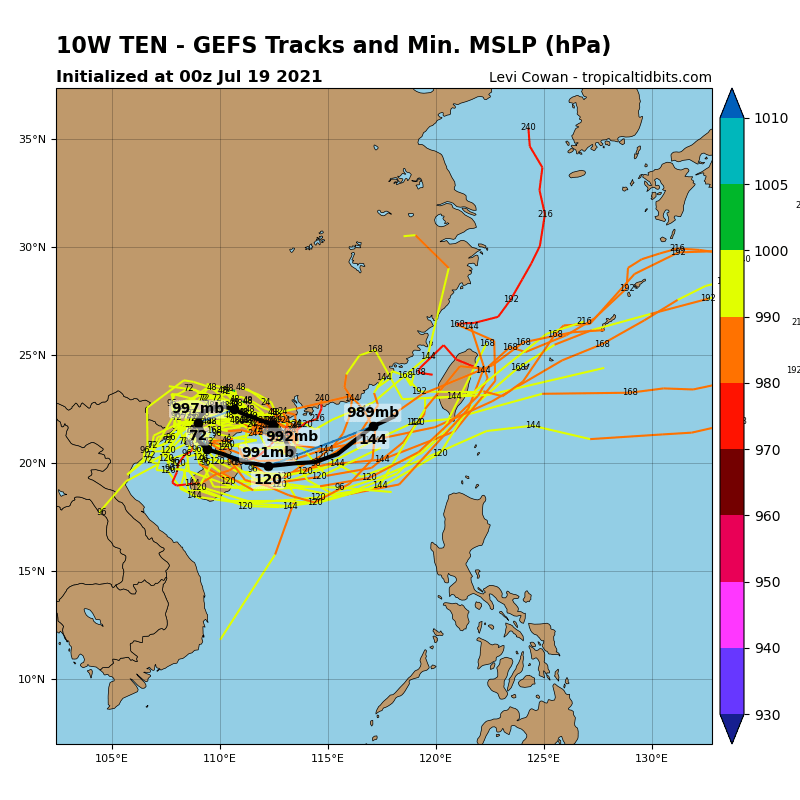


Figure 1 - GFS (top) and ECMWF (bottom) ensemble forecast on July 16 (left) and 19 (right) [Images from Tropical Tidbits and weather.us]
圖 1 - 7 月 16 日 (左) 及 19 日 (右) 之 GFS (上) 及 ECMWF (下) 模式集成預報圖 [圖像取自 Tropical Tidbits 及 weather.us]
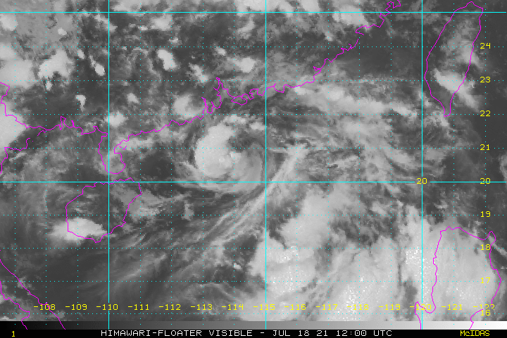
Figure 2 - Satellite image of 99W at 8 pm July 18
圖 2 - 7 月 18 日下午 8 時 99W 之衛星雲圖
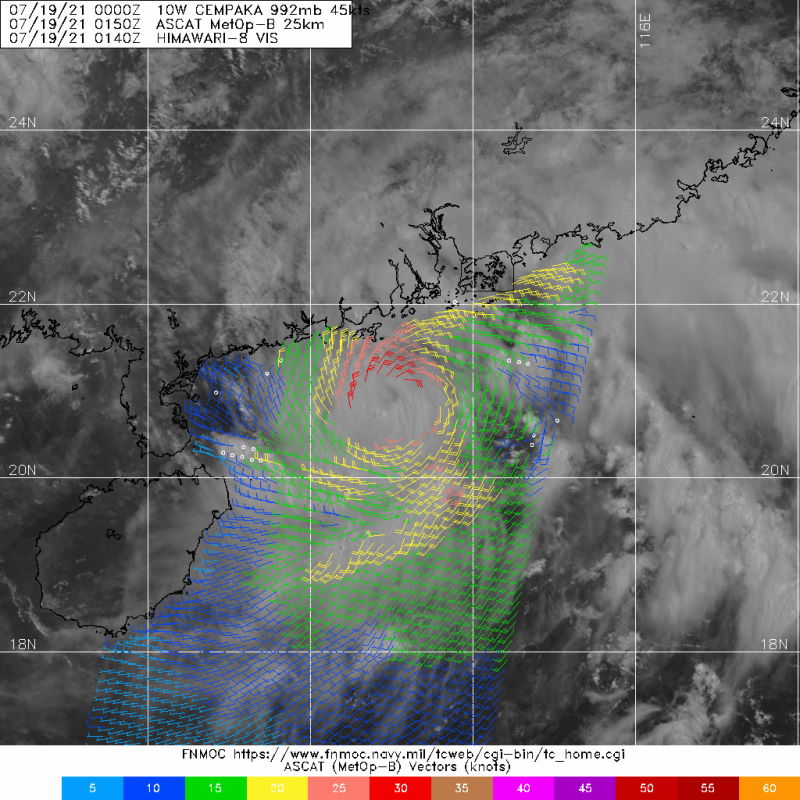
Figure 3 - Wind field analysis at 9:50 am July 19 showing CEMPAKA's small coverage
圖 3 - 7 月 19 日上午 9 時 50 分之風場掃描顯示查帕卡覆蓋範圍較細

Figure 4 - Steering flow chart at 8 am July 19
圖 4 - 7 月 19 日上午 8 時之駛流場分佈圖

Figure 5 - Forecast tracks from various official agencies in the night of July 19
圖 5 - 7 月 19 日晚間各官方氣象台之預測路徑

Figure 6 - HKO's forecast track and estimated wind radii for CEMPAKA at 8 am July 20
圖 6 - 7 月 20 日上午 8 時香港天文台對查帕卡發出的路徑預測及風圈估計

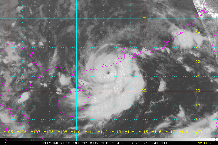
Figure 7 - Satellite images of CEMPAKA at 5:30 am (top) and 1 pm (bottom) July 20. CEMPAKA's eye can be clearly seen.
圖 7 - 查帕卡於 7 月 20 日上午 5 時 30 分 (上) 及下午 1 時 (下) 之衛星雲圖,其風眼清晰可見
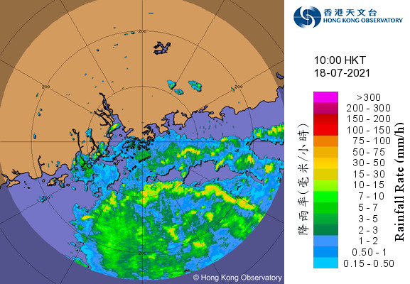


Figure 8 - Radar images at 12-hour intervals from 10 am July 18 to 10 pm July 20
圖 8 - 7 月 18 日上午 10 時至 20 日下午 10 時每 12 小時之雷達圖

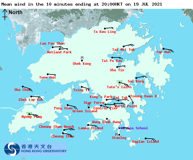
Figure 9 - Local wind distribution maps at noon (left) and 8 pm (right) July 19
圖 9 - 7 月 19 日正午 (左) 及下午 8 時 (右) 之本港風勢分布圖


Figure 10 - Wind speed time series at Cheung Chau, Kowloon Star Ferry Pier and Tap Mun (top to bottom) on July 19
圖 10 - 長洲、九龍天星碼頭及塔門 (上至下) 於 7 月 19 日之風速時間序列圖
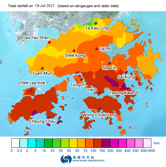

Figure 11 - Rainfall distribution map for July 19 (left) and 20 (right)
圖 11 - 7 月 19 (左) 及 20 日 (右) 之雨量分佈圖

Figure 12 - Satellite image of CEMPAKA as it moved south in the Gulf of Tonkin
圖 12 - 查帕卡於北部灣南移時之衛星雲圖

Figure 13 - Vertical wind shear distribution at 8 am July 24 (CEMPAKA indicated as "L" on the chart; two other tropical cyclones, IN-FA near Taiwan and NEPARTAK further east, are also shown)
圖 13 - 7 月 24 日上午 8 時之垂直風切變水平分布圖 (查帕卡標示為 "L",亦可見其餘兩個熱帶氣旋:於台灣附近的煙花及其東面的尼伯特)
| Winds Recorded at Reference Stations 參考站所錄得的風速 |
The following table lists the maximum 10-minute average (sustained) wind speed recorded while tropical cyclone signals were in force. In some occasions, it is possible that the strongest winds were not recorded when the highest signal was in force.
下表列出各站於熱帶氣旋警告信號生效時所錄得的最高 10 分鐘平均 (持續) 風速,留意此風速不一定於最高信號生效期間錄得。
| Station 風速站 |
Max. 10-min avg. wind speed 最高十分鐘平均風速 |
Beaufort classification 蒲福氏風級分類 |
| Chek Lap Kok 赤鱲角 | 38 km/h | Fresh 清勁 |
| Cheung Chau 長洲 | 57 km/h | STRONG 強風 |
| Kai Tak 啟德 | 32 km/h | Fresh 清勁 |
| Lau Fau Shan 流浮山 | 36 km/h | Fresh 清勁 |
| Sai Kung 西貢 | 46 km/h | STRONG 強風 |
| Sha Tin 沙田 | Below "fresh" threshold of 31 km/h 低於「清勁」下限的 31 km/h | |
| Ta Kwu Ling 打鼓嶺 | Below "fresh" threshold of 31 km/h 低於「清勁」下限的 31 km/h | |
| Tsing Yi (SHL) 青衣蜆殼油庫 | Below "fresh" threshold of 31 km/h 低於「清勁」下限的 31 km/h | |
| Number of stations recording at least STRONG force (force 6 - 7) winds: | 2 |
| Number of stations recording at least GALE force (force 8 - 9) winds: | 0 |
| Number of stations recording at least STORM force (force 10 - 11) winds: | 0 |
| Number of stations recording HURRICANE force (force 12) winds: | 0 |
| 錄得 強風 (6 - 7 級) 或更高風速的站數: | 2 |
| 錄得 烈風 (8 - 9 級) 或更高風速的站數: | 0 |
| 錄得 暴風 (10 - 11 級) 或更高風速的站數: | 0 |
| 錄得 颶風 (12 級) 風速的站數: | 0 |
| Charts and Figures 各項數據 |
Table 1: Track data from HKWW:
表一 : 香港天氣觀測站之路徑資料
YYMMDDZZ Lat Long Wind |
Table 2: Maximum gust and hourly average wind speed recorded in Hong Kong from HKO:
表二 : 香港天文台公佈的各站最高每小時平均風力和陣風數據 (英文)
Maximum Gust |
Maximum Hourly Mean Wind |
|||||||
|---|---|---|---|---|---|---|---|---|
| Direction |
Speed (km/h) |
Date/Month |
Time |
Direction |
Speed (km/h) |
Date/Month |
Time |
|
| Central Pier | ESE | 55 | 20/7 | 03:22 | E | 32 | 19/7 | 11:00 |
| Cheung Chau | ESE | 75 | 19/7 | 12:05 | ESE | 44 | 20/7 | 00:00 |
| Cheung Chau Beach | ENE | 75 | 19/7 | 12:00 | ENE | 47 | 19/7 | 13:00 |
| Hong Kong International Airport | E | 51 | 19/7 | 12:35 | E | 30 | 19/7 | 22:00 |
| Kai Tak | NE | 63 | 19/7 | 00:18 | E | 25 | 19/7 | 15:00 |
| King's Park | E | 53 | 19/7 | 20:42 | E | 21 | 19/7 | 21:00 |
| Lamma Island | ESE | 60 | 19/7 | 12:06 | E | 27 | 19/7 | 13:00 |
| Lau Fau Shan | E | 53 | 19/7 | 15:55 | E | 24 | 19/7 | 16:00 |
| Ngong Ping | E | 96 | 20/7 | 06:10 | E | 69 | 19/7 | 18:00 |
| North Point | E | 54 | 19/7 | 07:35 | E | 33 | 19/7 | 11:00 |
| ENE | 54 | 19/7 | 10:47 | |||||
| Peng Chau | E | 58 | 19/7 | 12:56 | E | 39 | 19/7 | 18:00 |
| Ping Chau | ENE | 34 | 19/7 | 09:44 | E | 12 | 19/7 | 19:00 |
| Sai Kung | E | 86 | 18/7 | 22:58 | ENE | 34 | 19/7 | 11:00 |
| Sha Chau | ESE | 54 | 19/7 | 12:39 | ESE | 34 | 19/7 | 18:00 |
| Sha Lo Wan | E | 53 | 19/7 | 16:50 | E | 25 | 19/7 | 17:00 |
| Sha Tin | E | 39 | 19/7 | 15:10 | NE | 14 | 18/7 | 23:00 |
| SE | 39 | 19/7 | 16:47 | |||||
| Star Ferry (Kowloon) | E | 54 | 19/7 | 23:42 | E | 28 | 19/7 | 15:00 |
| Ta Kwu Ling | ESE | 50 | 19/7 | 13:57 | E | 16 | 19/7 | 16:00 |
| Tai Mei Tuk | E | 76 | 18/7 | 23:05 | E | 42 | 19/7 | 18:00 |
| Tai Mo Shan | ESE | 89 | 19/7 | 18:55 | E | 62 | 19/7 | 18:00 |
| Tai Po Kau | E | 61 | 18/7 | 23:11 | E | 32 | 19/7 | 19:00 |
| Tap Mun East | E | 89 | 18/7 | 22:53 | ESE | 48 | 19/7 | 15:00 |
| Tate's Cairn | ESE | 86 | 19/7 | 00:14 | ESE | 56 | 19/7 | 18:00 |
| ESE | 86 | 19/7 | 00:15 | |||||
| Tseung Kwan O | NNE | 40 | 19/7 | 00:21 | N | 6 | 19/7 | 01:00 |
| Tsing Yi Shell Oil Depot | E | 51 | 19/7 | 02:46 | ESE | 19 | 20/7 | 19:00 |
| Tuen Mun Government Offices | NE | 37 | 19/7 | 03:02 | NNE | 11 | 20/7 | 07:00 |
| Waglan Island | ESE | 75 | 19/7 | 12:22 | E | 53 | 19/7 | 11:00 |
| ESE | 75 | 19/7 | 12:24 | |||||
| Wetland Park | E | 36 | 18/7 | 23:35 | E | 12 | 19/7 | 19:00 |
| Wong Chuk Hang | - | 51 | 19/7 | 00:36 | - | 18 | 19/7 | 11:00 |
Table 3: Rainfall (in millimetres) contributed by CEMPAKA from HKO (figures in brackets are based on incomplete hourly data):
表三 : 香港天文台公佈的各站雨量資料 (英文) (方括號內之數據由不完整之每小時資料擷取)
| 18-Jul |
19-Jul |
20-Jul |
Total Rainfall (mm) |
||
|---|---|---|---|---|---|
| Hong Kong Observatory (HKO) | 42.4 |
117.2 |
87.8 |
247.4 |
|
| Hong Kong International Airport (HKA) | 12.6 |
104.5 |
137.1 |
254.2 |
|
| Cheung Chau (CCH) | [38.5] |
[142.0] |
[128.0] |
[308.5] |
|
| H23 | Aberdeen | 57.5 |
93.5 |
82.5 |
233.5 |
| N05 | Fanling | 5.0 |
52.5 |
109.5 |
167.0 |
| N13 | High Island | 47.0 |
62.5 |
141.5 |
251.0 |
| K04 | Jordan Valley | 48.0 |
170.5 |
162.5 |
381.0 |
| N06 | Kwai Chung | 24.0 |
112.0 |
112.0 |
248.0 |
| H12 | Mid Levels | 54.0 |
114.0 |
102.0 |
270.0 |
| N09 | Sha Tin | 40.5 |
92.5 |
166.0 |
299.0 |
| H19 | Shau Kei Wan | 80.0 |
130.5 |
107.0 |
317.5 |
| SEK | Shek Kong | [14.0] |
[64.5] |
[118.5] |
[197.0] |
| K06 | So Uk Estate | 29.0 |
126.5 |
100.5 |
256.0 |
| R31 | Tai Mei Tuk | 8.0 |
45.5 |
116.0 |
169.5 |
| R21 | Tap Shek Kok | 5.5 |
52.5 |
123.5 |
181.5 |
| TMR | Tuen Mun Reservoir | 5.0 |
62.1 |
120.1 |
187.2 |
Last Accessed 最近訪問日期: Sat Apr 20 2024 06:25:17 HKT
Last Modified 最近修訂日期: Tue Sep 26 2023
