MANGKHUT is the 26th name in the tropical cyclone name list. It was contributed by Thailand, meaning mangosteen. This name replaced DURIAN which devastated the Philippines and Vietnam in 2006.
10W has intensified into a tropical storm and was named MANGKHUT. The storm has entered the Gulf of Tonkin. At 2 pm, MANGKHUT was centred about 310 km (170 NM) SE of Hanoi.
MANGKHUT is the 26th name in the tropical cyclone name list. It was contributed by Thailand, meaning mangosteen. This name replaced DURIAN which devastated the Philippines and Vietnam in 2006.
MANGKHUT is expected to move NW steadily under the subtropical ridge's southwestern periphery towards northern Vietnam.
山竹將沿副熱帶高壓脊西南部穩定向西北移動,趨向越南北部。
Intensity
Analysis 強度分析
Current T-number: T3.0/3.0/D1.0/24 HRS
MANGKHUT's convections are more concentrated at its southwestern quadrant. As the storm is now close to landfall intensification is not expected. MANGKHUT will weaken rapidly as it crosses Vietnam.
現時的 T 號碼: T3.0/3.0/D1.0/24 HRS
山竹的對流集中於其西南象限。由於風暴即將登陸,預料將不會增強,並於登陸後橫過越南時快速減弱。
Effects on
Hong Kong 對香港的影響
No threat to Hong Kong is expected within the next 72 hours.
山竹於未來的 72 小時將不會對香港構成任何影響。
Next Update
下次更新
2013/08/08 (Thu 四), afternoon 下午 (or earlier 或更早)
Other Images
其他圖像
JTWC Track 聯合颱風警報中心路徑圖
JMA Track 日本氣象廳路徑圖
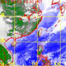
HKO Satellite 香港天文台衛星圖
HKO Track 香港天文台路徑圖
Probabilities
of TC Signals from HKO 香港天文台發出 / 取消熱帶氣旋警告信號的機率
The subtropical ridge is anchored northeast of 10W. Under this steering pattern 10W is expected to move northwest throughout the forecast period towards northern Vietnam. There is also a chance that it will make landfall at western Hainan.
Current T-number: T2.0/2.0/INT OBS
10W is currently quite disorganized and is consolidating. Under low shear and high sea temperatures the storm should be able to intensify into a tropical storm before landfall.
現時的 T 號碼: T2.0/2.0/INT OBS
10W 現時顯得較為散亂,正逐漸整合。在低垂直風切變及高海溫的環境下,10W 將能於登陸前增強為熱帶風暴。
Effects on
Hong Kong 對香港的影響
As 10W is a rather small system and at a considerable distance from Hong Kong, no threat to the territory is expected within the next 72 hours.
由於 10W 尺度較小且距離香港較遠,預料其於未來的 72 小時將不會對香港構成任何影響。
Next Update
下次更新
2013/08/07 (Wed 三), afternoon 下午 (or earlier 或更早)
Other Images
其他圖像
JTWC Track 聯合颱風警報中心路徑圖
JMA Track 日本氣象廳路徑圖
HKO Satellite 香港天文台衛星圖
HKO Track 香港天文台路徑圖
Probabilities
of TC Signals from HKO 香港天文台發出 / 取消熱帶氣旋警告信號的機率
Signal 信號
t+12
t+24
t+36
t+48
t+60
t+72
Standby 戒備 #1
Low 低
Strong Wind 強風 #3
Gale/Storm 烈或暴風 #8
G/S Incr. 烈或暴風增強 #9
Hurricane 颶風 #10
Notes 註:
1) For issuance, "Signal" column represents having issued that signal or above. 有關發出機率,首欄指已發出該信號或更高信號。
2) "Low" = Probability from 5 to 20 per cent; "Medium" = 20 to 50%; "High" = 50 to 80%; "V High" = 80% or above.
"低" = 5% - 20% 的機率; "中等" = 20 - 50%; "高" = 50 - 80%; "極高" = 80% 或以上。
 Active Tropical Cyclone(s) 正活躍之熱帶氣旋