
TC Watch > Selected TC Review > 200819W (JANGMI) [Refresh]
 200819W (JANGMI) - Profile 200819W (JANGMI) - Profile |
(Issued on October 10th, 2008)
Brief profile of JANGMI:
| JTWC number | 19W |
| International number | 0815 |
| Period of existence | 24 September, 2008 02 HKT to 1 October, 2008 02 HKT |
| Lifetime | 7.00 days |
| Maximum 1-minute wind (JTWC) | 145 knots |
| Minimum pressure (JTWC) | 914 hPa |
| Highest TC signal by HKO (if applicable) | N/A |
| Closest point of approach by HKO (if applicable) | N/A |
| Time of closest approach by HKO (if applicable) | N/A |
| Lowest pressure recorded at HKO (if applicable) | N/A |
TC track from HKWW:
| Past HKWW Bulletins on JANGMI |
Please click here for bulletins on JANGMI.
| Storm Summary |
JANGMI was the first category 5 super typhoon in 2008.
A disturbance developed to the northeast of Yap and subsequently intensified into a tropical depression on September 24th, and the JTWC gave it the temporary number 19W. Models diverged on 19W's future track, with some models forecasting a stronger ridge to drive the system into the South China Sea, some putting the system at Taiwan and some even depicting a recurvature. Initial forecasts by various agencies seemed to agree that the ridge supporting 19W's WNW motion would weaken a few days later and thus a NW movement was expected, but the ridge would strengthen later to provide a WNW track, a scenario that was similar to that of 18W (HAGUPIT) which brought a Signal 8 to Hong Kong earlier that month.
JANGMI intensified steadily while travelling WNW. The JMA upgraded 19W into a tropical storm at 20 HKT the same day and named it JANGMI, a name provided by South Korea meaning (a type of) rose. JANGMI intensified into a severe tropical storm early on September 25th and its track shifted westward, possibly due to re-organization of its circulation.
The ridge weakened the day after and JANGMI was propelled NNW then NW during September 26th. JANGMI was upgraded to typhoon by the JMA and the HKO at 02 HKT on that day. It travelled NW while intensifying steadily for the rest of the day, reaching 120 knots in 1-minute standard by the end of September 26th.
The CWB of Taiwan issued the sea typhoon warning at 23:30 HKT on September 26th as JANGMI was expected to affect seas near Taiwan in the coming 24 hours. Already a major tropical cyclone, JANGMI continued to intensify early on September 27th which prompted the CWB to upgrade the system into a severe typhoon. The CWB issued the land and sea typhoon warning at 08:30 HKT and predicted that JANGMI would make landfall in southern Taiwan on the next day. The JTWC estimated JANGMI's intensity to be 135 knots (upper limit of a category 4 typhoon) and was therefore a super typhoon by 08 HKT.
JANGMI reached peak intensity in the early afternoon of September 27th. However most agencies revised their strength significantly upward only in the 20 HKT's bulletin, possibly because aircraft reconnaissance in the afternoon (see Table 3) showed a minimum pressure of 906 hPa and a flight-level maximum wind speed of 163 knots. The JTWC's maximum wind speed (1-minute average) reported operationally was 135 knots, but revised upward to 145 knots later during in-season best track analysis which made JANGMI the most intense storm (as a category 5 super typhoon) so far this year. The JMA estimated JANGMI's maximum winds (10-minute average) at 115 knots, the first storm to "beat" the 110-knot barrier in nearly a decade. However, the most abrupt change in intensity was reported by the HKO (10-minute average), from 100 knots (185 km/h) at 08 HKT that day to 125 knots (232 km/h) at 20 HKT the same day with a pressure of 900 hPa. The T-number observed from satellite imageries was estimated to be 7.0.
By that time, the ridge has weakened considerably and a recurvature was becoming very likely.
JANGMI shifted a bit towards WNW during September 27th, but resumed a NW motion from September 28th. Proximity to land led to its weakening into a category 4 cyclone and it made landfall at Ilan during the afternoon of September 28th at a strength of 115 knots (JTWC) / 110 knots (JMA) / 115 knots (HKO). JANGMI brought heavy rainfall and extremely strong winds to Taiwan.
JANGMI lingered in northern Taiwan for quite some time before eventually emerging at Taoyuan at about 04:20 HKT on September 29th. Interactions with Taiwan's mountains severely damaged JANGMI's structure, and it could only manage to go back into open seas as a severe tropical storm. JANGMI travelled parallel to the coastline of Zhejiang during the day while weakening gradually.
After crossing the ridge axis, JANGMI turned eastward along the northern periphery of the subtropical ridge on September 30th, and transformed into an extratropical cyclone before reaching the seas south of Japan early on October 1st.
| Figures |

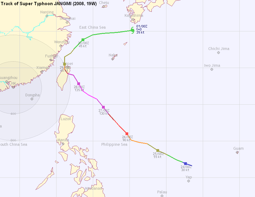
Figure 1 - Initial track by various agencies
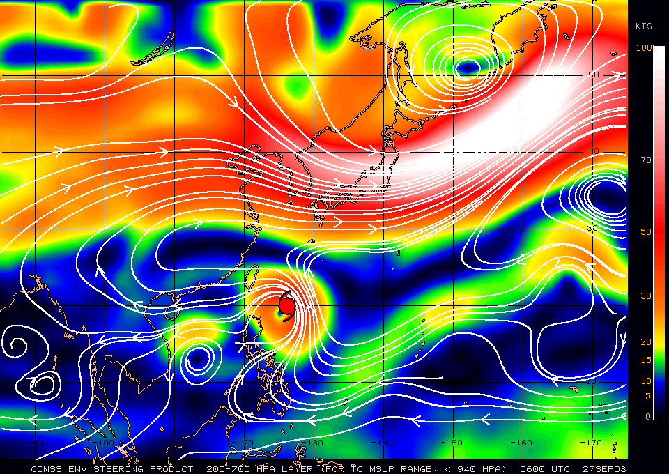
Figure 2 - Steering flow chart at 14 HKT on September 27th

Figure 3 - Visible imagery of JANGMI near peak intensity (14:30 HKT, September 27th)

Figure 4 - Infrared imagery of JANGMI near peak intensity (21 HKT, September 27th)

Figure 5 - Calculated wind field of JANGMI near peak intensity (14 HKT, September 27th). Note the inner 110-knot wind area.
| Other Data |
Table 1: Track data from HKWW:
YYMMDDZZ Lat Long Wind |
Table 2: Track data from JTWC:
ID Name YYMMDD ZZZZ Lat Long Basin Wind Pres 19W JANGMI 081001 0600 30.1N 133.3E WPAC 35 996 19W JANGMI 081001 0000 30.2N 130.5E WPAC 35 996 19W JANGMI 080930 1800 30.1N 128.4E WPAC 35 996 19W JANGMI 080930 1200 29.9N 126.7E WPAC 45 989 19W JANGMI 080930 0600 29.5N 125.1E WPAC 45 989 19W JANGMI 080930 0000 28.7N 123.8E WPAC 45 989 19W JANGMI 080929 1800 27.8N 122.7E WPAC 45 989 19W JANGMI 080929 1200 27.3N 122.1E WPAC 55 982 19W JANGMI 080929 1200 27.3N 122.1E WPAC 55 982 19W JANGMI 080929 0600 26.7N 121.4E WPAC 55 982 19W JANGMI 080929 0600 26.7N 121.4E WPAC 55 982 19W JANGMI 080929 0000 25.7N 121.1E WPAC 60 978 19W JANGMI 080929 0000 25.7N 121.1E WPAC 60 978 19W JANGMI 080928 1800 24.8N 121.5E WPAC 75 967 19W JANGMI 080928 1800 24.8N 121.5E WPAC 75 967 19W JANGMI 080928 1800 24.8N 121.5E WPAC 75 967 19W JANGMI 080928 1200 24.1N 121.4E WPAC 85 959 19W JANGMI 080928 1200 24.1N 121.4E WPAC 85 959 19W JANGMI 080928 1200 24.1N 121.4E WPAC 85 959 19W JANGMI 080928 0900 24.7N 121.7E WPAC 115 937 19W JANGMI 080928 0900 24.7N 121.7E WPAC 115 937 19W JANGMI 080928 0900 24.7N 121.7E WPAC 115 937 19W JANGMI 080928 0600 23.9N 122.4E WPAC 115 937 19W JANGMI 080928 0600 23.9N 122.4E WPAC 115 937 19W JANGMI 080928 0600 23.9N 122.4E WPAC 115 937 19W JANGMI 080928 0000 22.9N 123.2E WPAC 130 926 19W JANGMI 080928 0000 22.9N 123.2E WPAC 130 926 19W JANGMI 080928 0000 22.9N 123.2E WPAC 130 926 19W JANGMI 080927 1800 21.8N 123.7E WPAC 135 922 19W JANGMI 080927 1800 21.8N 123.7E WPAC 135 922 19W JANGMI 080927 1800 21.8N 123.7E WPAC 135 922 19W JANGMI 080927 1200 21.3N 124.4E WPAC 140 918 19W JANGMI 080927 1200 21.3N 124.4E WPAC 140 918 19W JANGMI 080927 1200 21.3N 124.4E WPAC 140 918 19W JANGMI 080927 0600 20.7N 125.6E WPAC 145 914 19W JANGMI 080927 0600 20.7N 125.6E WPAC 145 914 19W JANGMI 080927 0600 20.7N 125.6E WPAC 145 914 19W JANGMI 080927 0000 19.7N 126.4E WPAC 135 922 19W JANGMI 080927 0000 19.7N 126.4E WPAC 135 922 19W JANGMI 080927 0000 19.7N 126.4E WPAC 135 922 19W JANGMI 080926 1800 18.7N 127.2E WPAC 120 933 19W JANGMI 080926 1800 18.7N 127.2E WPAC 120 933 19W JANGMI 080926 1800 18.7N 127.2E WPAC 120 933 19W JANGMI 080926 1200 17.8N 128.0E WPAC 105 944 19W JANGMI 080926 1200 17.8N 128.0E WPAC 105 944 19W JANGMI 080926 1200 17.8N 128.0E WPAC 105 944 19W JANGMI 080926 0600 16.9N 128.9E WPAC 95 952 19W JANGMI 080926 0600 16.9N 128.9E WPAC 95 952 19W JANGMI 080926 0600 16.9N 128.9E WPAC 95 952 19W JANGMI 080926 0000 15.9N 129.7E WPAC 90 956 19W JANGMI 080926 0000 15.9N 129.7E WPAC 90 956 19W JANGMI 080926 0000 15.9N 129.7E WPAC 90 956 19W JANGMI 080925 1800 15.1N 130.3E WPAC 80 963 19W JANGMI 080925 1800 15.1N 130.3E WPAC 80 963 19W JANGMI 080925 1800 15.1N 130.3E WPAC 80 963 19W JANGMI 080925 1200 14.6N 131.4E WPAC 70 970 19W JANGMI 080925 1200 14.6N 131.4E WPAC 70 970 19W JANGMI 080925 1200 14.6N 131.4E WPAC 70 970 19W JANGMI 080925 0600 14.5N 132.4E WPAC 65 974 19W JANGMI 080925 0600 14.5N 132.4E WPAC 65 974 19W JANGMI 080925 0000 13.9N 133.6E WPAC 55 982 19W JANGMI 080925 0000 13.9N 133.6E WPAC 55 982 19W JANGMI 080924 1800 13.2N 135.1E WPAC 50 985 19W JANGMI 080924 1200 12.7N 136.3E WPAC 45 989 19W JANGMI 080924 0600 12.2N 137.2E WPAC 45 989 19W JANGMI 080924 0000 11.8N 137.9E WPAC 35 996 19W JANGMI 080923 1800 11.4N 138.6E WPAC 30 1000 19W JANGMI 080923 1200 10.9N 139.5E WPAC 25 1004 19W JANGMI 080923 0600 10.7N 140.2E WPAC 20 1007 19W JANGMI 080923 0000 10.6N 140.8E WPAC 15 1010 19W JANGMI 080922 1800 10.4N 141.6E WPAC 15 1010 |
Table 3: Aircraft reconnaissance report (Data at 14:55 HKT, September 27th)
URPA12 PGUA 270755 VORTEX DATA MESSAGE A. 27/07:55:30Z B. 20 deg 58 min N 125 deg 05 min E C. 700 mb 2294 m D. 118 kt E. 135 deg 10 nm F. 237 deg 136 kt G. 137 deg 11 nm H. 906 mb I. 12 C / 3049 m J. 24 C / 3043 m K. 9 C / NA L. CLOSED M. C18 N. 12345 / 7 O. 0.02 / 1.5 nm P. AF306 0747W JANGMI OB 28 MAX FL WIND 163 KT E QUAD 06:16:40Z SFC CNTR 360 / 4 NM FROM FL CNTR WELL DEVELOPED EYE, FULL STADIUM EFFECT VISIBLE WITH SEVERAL STRAITIONS IN EYEWALL CLOUDS RUNNING DIAGONALLY ALONG WALL SURFACE FROM TOP TO BASE. |
Last Accessed: Sat May 18 2024 20:18:34 HKT
Last Modified: Mon Jul 24 2023
