
TC Watch / 熱帶氣旋 > Selected TC Review / 重要熱帶氣旋回顧 > 200908W (GONI 天鵝) [Refresh 更新]
 200908W (GONI 天鵝) - Profile 檔案 200908W (GONI 天鵝) - Profile 檔案 |
(First draft issued on August 18th, 2009; final version issued on August 21st, 2009)
(初稿於 2009 年 8 月 18 日發出,最後版本於 8 月 21 日上載)
Brief profile of GONI 天鵝小檔案:
| JTWC number 聯合颱風警報中心 (JTWC) 號碼 | 08W |
| International number 國際編號 | 0907 |
| Period of existence 生存時期 | 3 August, 2009 02 HKT to 9 August, 2009 02 HKT (JTWC) 1 August, 2009 02 HKT to 9 August, 2009 20 HKT (HKO) |
| Lifetime 壽命 | 6.00 days 日 (JTWC); 8.75 days 日 (HKO) |
| Maximum 1-minute wind (JTWC) JTWC 一分鐘平均最高中心風速 | 45 knots 節 (Tropical Storm 熱帶風暴) |
| Minimum pressure (JTWC) JTWC 最低氣壓 | 988 hPa 百帕 |
| Highest TC signal by HKO (if applicable) 香港天文台發出最高熱帶氣旋警告信號 |
8 (SE) (Gale or Storm Signal 烈風或暴風信號) |
| Closest point of approach by HKO (if applicable) 香港天文台所示之最接近距離 (如適用) |
SW 100 km 公里 (real-time warning 實時報告) / SW 110 km 公里 (TC report 熱帶氣旋報告) |
| Time of closest approach by HKO (if applicable) 香港天文台所示之最接近時間 (如適用) |
4 August, 2009 21-22 HKT (real-time warning 實時報告) / 20-22 HKT (TC report 熱帶氣旋報告) |
| Lowest pressure recorded at HKO (if applicable) 香港天文台錄得的最低氣壓 (如適用) |
993.5 hPa 百帕 (4 August, 2009 17:03 HKT) |
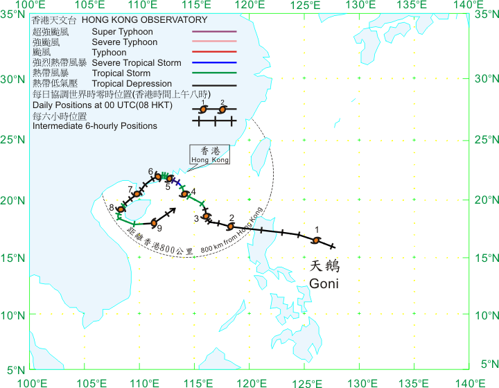
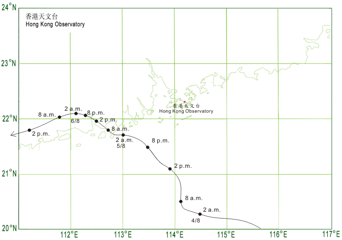
TC signals for Hong Kong & Track 香港曾經生效的熱帶氣旋警告和路徑圖:
Table 表:
| Signal 信號 |
Date and time 日期和時間 |
Distance from HK 與香港的距離 |
Predicted movement 預測移動方向和速度 |
Max. 10-min winds 中心最高十分鐘平均風速 |
 |
2009/08/03 (MON) 15:15 HKT | SSE 400 km | N at 12 km/h | 56 km/h (30 knots, TD) |
 |
2009/08/04 (TUE) 11:15 HKT | S 170 km | NW/NNW at 12 km/h | 75 km/h (40 knots, TS) |
 |
2009/08/04 (TUE) 21:40 HKT | SW 100 km | NW/NNW at 10 km/h | 92 km/h (50 knots, STS) |
|
2009/08/05 (WED) 03:40 HKT | WSW 160 km | W at 10 km/h | 92 km/h (50 knots, STS) |
|
2009/08/05 (WED) 05:40 HKT | WSW 170 km | W at 10 km/h | 92 km/h (50 knots, STS) |
 |
2009/08/05 (WED) 16:00 HKT | W 190 km | W slowly | 83 km/h (45 knots, TS) |
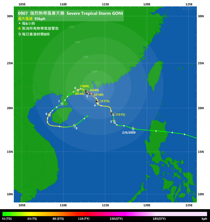
Figure 圖: (Track courtesy of Lorenzo. Data from HKO. 鳴謝 Lorenzo 提供路徑圖,資料取自天文台)
IR imagery animation 紅外線雲圖動畫:
TC track from HKWW 本站的熱帶氣旋路徑圖:
TC track from HKO 天文台的熱帶氣旋路徑圖:
| Past HKWW Bulletins on GONI 本站有關天鵝的發佈 |
Please click here for bulletins on GONI. 請按這裡。
| Storm Formation and Development 氣旋形成和發展 |
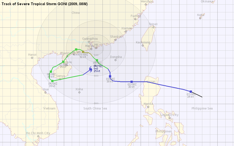
GONI's track is among the most unusual ones in recent years, partly due to the effect of another cyclone that was also present in the northwestern Pacific Ocean at that time.
A low pressure area developed east of Luzon in late July. The HKO upgraded it into a tropical depression early on August 1st, a rather unusual move as normally the JTWC precedes the HKO in upgrading to tropical depression status. It was once thought that the subtropical ridge, northwest of the depression at that time, would collapse and would provide a classic recurving scenario.
However, the unstable depression skipped past the Philippine Sea, and the original low-level circulation centre was replaced by another one much west of it. As a result, agencies revised the current position of the storm westward. The HKO revised the depression's location over a span of a few bulletins in the morning of August 2nd, which resulted an apparent track speed in excess of 100 km/h for a few hours that morning.
The task of predicting the depression's future movement became even more uncertain now. The subtropical ridge eventually retreated, which was expected to retard its westward movement. However, another storm developed east of Taiwan (which later became typhoon MORAKOT and eventually made landfall in Taiwan, bringing torrential rain that devastated parts of the region) and numerical models like ECMWF predicted that as it moved west, it would eventually interact with this depression. These factors resulted in the tremendous uncertainty in the track forecast.
受到另一股於西北太平洋上的熱帶氣旋影響,天鵝的路徑為近年來最罕見之一。
一個低壓區於 7 月底在呂宋以東形成。天文台於 8 月 1 日將其升格為熱帶低氣壓,比 JTWC 升格的時間為早。初時預測於該熱帶低氣壓西北部的副熱帶高壓脊將逐漸減弱並令其轉向。
但是,該低壓的中心並不穩定,它快速橫過菲律賓以東海域,原先的低層環流中心被其西面新形成的中心代替。因此,各站紛紛把該低壓的位置西移,而香港天文台則於 2 日早上用了數次發佈來逐漸調整氣旋位置,令其移速看上來達每小時 100 公里。
該氣旋的未來動向變得更難預計。盤踞於中國的高壓退卻,令該氣旋西移速度減慢;同時,一股氣旋於台灣以東形成 (稍後被命名為莫拉克,移向台灣並引發大雨,是為八八水災)。部分數值模式如歐洲中期天氣預報中心之預測預料新形成的低壓將逐漸西移並最終與現時於南海的氣旋發生相互影響。這些不確定的因素令預測難度大增。


Figures 1a and 1b - IR imageries of the depression
圖 1a 及 1b - 顯示該熱帶低氣壓之紅外線衛星雲圖

Figure 2 - HKO's gradual relocation in the morning of August 2nd.
圖 2 - 天文台於 8 月 2 日早上的逐步重新定位

Figure 3 - ECMWF's t+168 prediction at 08 HKT August 2nd
圖 3 - 歐洲中期天氣預報中心之數值模式預測圖 (t+168, 8 月 2 日上午 8 時)
| Northward Turn in the South China Sea 於南海上北轉 |
Responding to the retreat of the subtropical ridge, the depression slowed down in the night of August 2nd, and effective consolidation could finally take place. The JTWC upgraded, in their opinion, this low pressure area into tropical depression 08W at 02 HKT on August 3rd, predicting a recurvature towards eastern Guangdong and western Fujian.
08W moved north slowly in the rest of the day. Seeing an increased chance that recurvature would not occur, the HKO made a major change in their track forecast, which put the cyclone directly over Hong Kong about two days later with tropical storm intensity. The Observatory issued the #1 Standby Signal at 15:15 HKT to warn the public about the approaching cyclone.
由於副高減弱,該熱帶低氣壓的移速於 2 日晚上減低,從而令其得以整固。JTWC 於 3 日上午 2 時升格該低壓區為熱帶低氣壓 08W,並預料 08W 會轉向並趨向廣東東部和福建西部一帶。
08W 於 3 日餘下時間移動緩慢。由於東向量的出現逐漸變得不可能,天文台於當天下午大幅更改其預測路徑,並預測 08W 於兩天後以熱帶風暴強度登陸香港。天文台並於下午 3 時 15 分發出一號戒備信號,用以提醒市民留意 08W 的動態。

Figure 4 - HKO's forecast track, pointing 08W towards Hong Kong
圖 4 - 天文台預測 08W 直趨本港
Although the storm was weak, the subsidence associated with it resulted in very hot weather in Hong Kong and the Very Hot Weather Warning was in force from August 1st to 3rd. The Observatory recorded an air temperature of 34.6 degrees Celsius on August 2nd, breaking the record high of the year. It was broken again on August 3rd when the Observatory's mercury reached 34.9 degrees. Wong Tai Sin registered 37.0 degrees on August 2nd, making it one of the major news items in that night's news report. Heavy showers affected the territory near 16 HKT on August 3rd, and in most places temperatures fell by at least 6 degrees.
雖然 08W 強度不高,但與其相關的下沉氣流令香港天氣悶熱,酷熱天氣警告於 1 至 3 日生效。天文台於 2 日下午錄得全年最高溫 34.6 度;該紀錄被一日後的 34.9 度打破。黃大仙氣象站更於 2 日下午錄得 37.0 度的高溫,令其成為當天其中一篇重要新聞。3 日約下午 4 時香港受到與 08W 相關連的大驟雨影響,大部分地區的氣溫急降 6 度或以上。
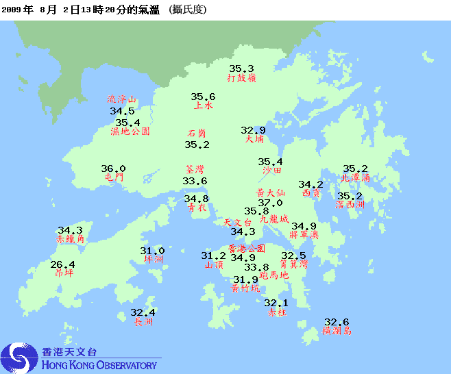
Figure 5 - Regional temperatures, 13:20 HKT on August 2nd
圖 5 - 8 月 2 日下午 1 時 20 分之分區溫度圖
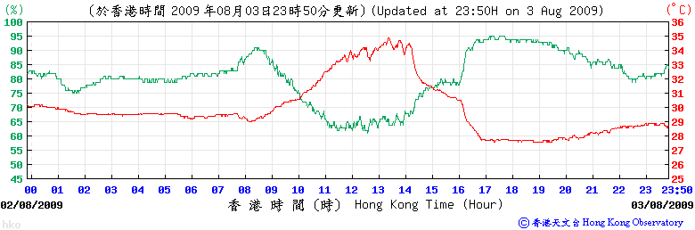
Figure 6 - Temperature and humidity readings of the HKO on August 3rd
圖 6 - 8 月 3 日天文台錄得的溫度和濕度

Figure 7 - 08W's outer rain band affecting Hong Kong
圖 7 - 08W 的外圍雨帶影響本港
Later that night the JMA directly upgraded 08W into tropical storm status (without the usual "Gale Warning") and named it GONI. The name GONI was contributed by South Korea, meaning swan. It is interesting to note that the previous cyclone named GONI (in 2003) was also the 8th JTWC tropical depression of that year and also necessitated tropical cyclone signals in Hong Kong. The JMA's initial track also put GONI very close to Hong Kong, and similar tracks were subsequently followed by the CWB of Taiwan and the JTWC.
Due to the highly aggressive forecast track and its probable effects on the coming Wednesday, the day that results of 2009's HKCEE were to be released, the general public paid quite a lot of attention to GONI.
3 日晚日本氣象廳直接升格 08W 為熱帶風暴 (而沒有預先發出熱帶氣旋烈風警告),並給予名稱 "天鵝"。天鵝一名由南韓提供。有趣的是上一個冠以天鵝一名的熱帶氣旋 (於 2003 年出現) 亦為該年 JTWC 第 8 個熱帶氣旋,同時亦令香港發出熱帶氣旋警告信號。日本氣象廳預計天鵝將非常接近香港,其後台灣的中央氣象局和 JTWC 亦作出類似預測。
由於天鵝的預測路徑頗具侵略性,而該週三為中學會考放榜的日子,市民普遍對此提高警覺。

Figure 8 - GONI's forecast tracks from different agencies
圖 8 - 不同機構對於天鵝的預測路徑
| Higher Signals in Hong Kong 更高的熱帶氣旋警告信號 |
GONI made a few westward jogs that night and a relocation was made near midnight on August 4th. By daybreak GONI was already due south of Hong Kong, still as a minimal tropical storm. As GONI edged closer to the territory, the Observatory raised the alarm to #3 Strong Wind Signal at 11:15 HKT when the storm was 170 km south of Hong Kong, and predicted that it would come within 100 km of Hong Kong that night.
GONI gradually picked up strength during the day, but the JMA still kept it as a 35-knot system (i.e. a minimal tropical storm). Due to the westward relocation of the cyclone, agencies generally shifted their forecast tracks west, with some predicting that GONI might return to sea again after touching land briefly.
天鵝於當晚多次向西跳動,天文台於 4 日凌晨時份再次作出重新定位。破曉時天鵝已於香港以南,但強度仍為熱帶風暴下限。隨著天鵝繼續靠近本港,天文台於上午 11 時 15 分發出三號強風信號,當時天鵝於香港以南約 170 公里處。天文台亦預測天鵝將於當晚於香港 100 公里附近掠過。
天鵝於當天逐步增強,但日本氣象廳一直把其強度維持於 35 節 (熱帶風暴下限強度)。由於氣旋於較早前西移,各機構把預測路徑向西調整,部分更預測天鵝於短暫接觸陸地後將返回海上。

Figure 9 - Visible imagery at 14:30 HKT on August 4th
圖 9 - 8 月 4 日下午 2 時 30 分的可見光衛星雲圖
Locally most places saw a mild increase in wind speed in the afternoon. Perhaps the most surprising piece of news that day was the South China Coastal Waters report issued by the Observatory at 16:30 HKT, which indicated that Huangmao Zhou (an island South of Hong Kong) recorded sustained wind speeds of force 11 coming from the east, implying that GONI's strength was more than a tropical storm. The Observatory then added the words "in the past few hours, GONI has shown signs of intensification" and said they would consider the need for higher signals later that night in the 17 HKT tropical cyclone bulletin and subsequently upgraded GONI into a severe tropical storm at 18 HKT.
GONI continued to move N/NNW and entered the region of 50% probability of gales in Victoria Harbour. The Observatory issued the Pre-No. 8 Special Announcement at 19:40 HKT and alerted the public that the #8 Signal would be issued by 21:45 HKT the latest. The #8 SE Gale or Storm Signal was issued at 21:40 HKT, with Cheung Chau blowing gale force winds at that time. The storm was also near its closest approach to Hong Kong, which was 100 km SW of the Observatory headquarters. Ferry services in the territory gradually stopped and, because the Macau had already hoisted the #8 Signal at 19 HKT, transport by sea between Hong Kong and Macau was suspended earlier.
本港多區風力於 4 日下午稍為增強。天文台於下午 4 時 30 分發出的華南海域天氣報告中揭示於香港以南的黃茅洲錄得持續風力達 11 級,暗示天鵝比一熱帶風暴要強。天文台遂於下午 5 時的發佈中加上 "過去數小時,天鵝有增強跡象" 一句,並說會於當晚稍後考慮改發更高信號。天文台終於下午 6 時升格天鵝為強烈熱帶風暴。
天鵝繼續向北至西北偏北移動,進入維港 50% 機會吹烈風 (俗稱 "豬腰") 範圍。天文台於晚上 7 時 40 分發出八號信號預警,並預料八號信號將於當晚 9 時 45 分或之前發出。其後天文台於晚上 9 時 40 分發出八號東南烈風或暴風信號,當時長洲正吹烈風。天鵝於當時最接近香港,於天文台西南約 100 公里掠過。港內渡輪服務相繼暫停,而由於澳門已於晚上 7 時改發八號東北風球,港澳間的渡輪服務已於較早時暫停。

Figure 10 - GONI's track at 19 HKT on August 4th
圖 10 - 天鵝於 8 月 4 日下午 7 時的路徑圖

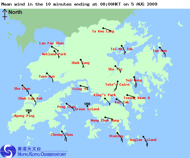
Figure 11 - Hong Kong regional weather, 21:30 HKT on August 4th
圖 11 - 8 月 4 日下午 9 時 30 分之香港分區天氣
| Landfall and Gradual Weakening 登陸並逐漸減弱 |
Although GONI was near its closest point of approach, winds in the territory generally weakened after the #8 Signal was issued. Near midnight, only Ngong Ping station recorded sustained gale force winds, with most other stations registering only strong force winds.
GONI also shifted to a westward track and was leaving Hong Kong by midnight on August 5th. Seeing a decreased threat, the Observatory replaced the #8 Signal with the #3 Strong Wind Signal at 03:40 HKT, and with the #1 Standby Signal at 05:40 HKT. Sustained strong winds were by then limited to offshore waters and on high grounds.
The China Meteorological Administration (CMA) reported that GONI had made landfall near Taishan at 06:20 HKT. However, instead of moving deeper inland, GONI skirted the coastal areas and maintained a rather good banding structure until later that day. It slowed down considerably in the meantime. For these reasons, it was not until 16:00 HKT that day, more than 10 hours after the #1 Signal was issued, that all signals were cancelled. As for its intensity, the HKO downgraded GONI into a tropical storm at 13 HKT.
The weather was unstable for the rest of the day. GONI's outer rain band swept past the territory that night, and the Amber Rainstorm Warning was in force from 20:40 HKT to 23 HKT on August 5th.
雖然天鵝於晚上 10 時附近最接近香港,但本港風力大多於八號信號生效後減弱。到了午夜時份,天文台公佈的報告中只剩下昂平高地站還吹烈風,大部分地區只剩下強風風速。
天鵝亦於 5 日凌晨時份改向偏西移動。隨著威脅減低,天文台分別於上午 3 時 40 分和 5 時 40 分改發三號和一號信號。日出附近只有離岸和高地吹強風。
中國氣象局表示天鵝於上午 6 時 20 分於台山登陸。天鵝其後並沒有大幅深入內陸,而只掠過沿岸區域,且速度減慢。為此,一號信號維持了超過 10 小時,最終於下午 4 時取消。強度方面,天文台於當天下午 1 時降格天鵝為熱帶風暴。
5 日天氣並不穩定。天鵝的外圍雨帶於當晚掃過本港,黃色暴雨警告信號於晚上 8 時 40 分發出,於晚上 11 時取消。

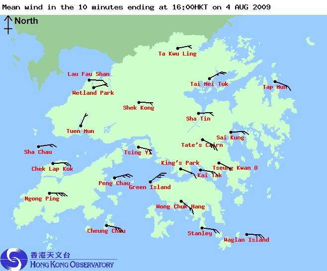


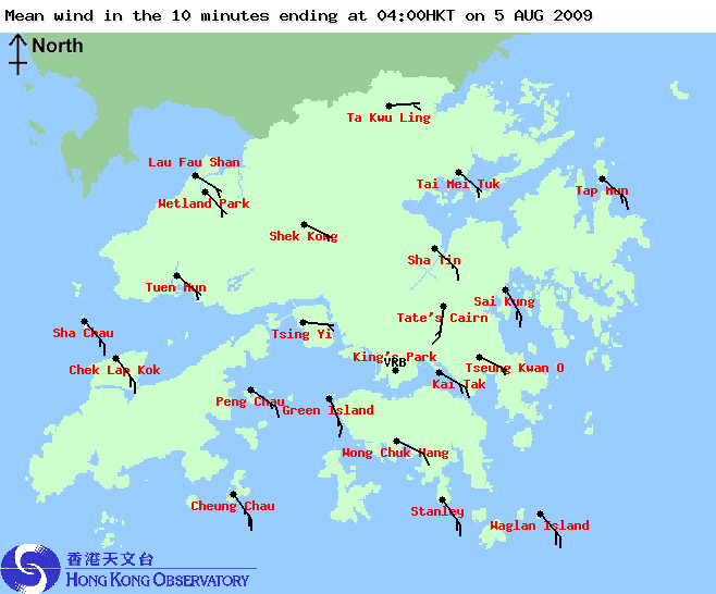
Figures 12a to 12f - Wind directions and speeds across Hong Kong at 12, 16 and 20 HKT of August 4th, and 00, 04 and 08 HKT of August 5th.
圖 12a 至 12f - 8 月 4 日中午 12 、下午 4 和 8 時,以及 5 日凌晨 12 、上午 4 和 8 時之風向和風速分布圖
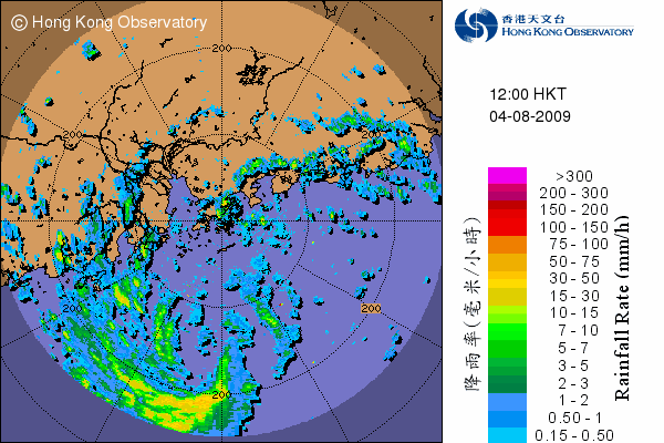


Figures 13a to 13f - GONI as seen on RADAR. Images were taken at 12, 16 and 20 HKT of August 4th, and 00, 04 and 08 HKT of August 5th.
圖 13a 至 13f - 8 月 4 日中午 12 、下午 4 和 8 時,以及 5 日凌晨 12 、上午 4 和 8 時之雷達圖
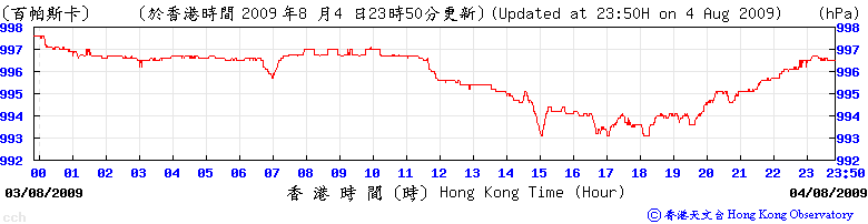

Figures 14a and 14b - Pressure readings at Cheung Chau and Hong Kong Observatory
圖 14a 和 14b - 長洲和天文台錄得的氣壓

Figure 15 - The rain band that necessitated the Amber Rainstorm Warning on August 5th
圖 15 - 令天文台於 8 月 5 日發出黃色暴雨警告信號的雨帶
| Circling around Hainan Island and Eventual Dissipation 圍繞海南並於海上消散 |
By August 6th the cyclone that formed east of Taiwan (MORAKOT) was already west of 130E, and was speeding westwards. Interactions between the systems increased, and with the help of an anticyclone NW of GONI, GONI moved southwest starting from the afternoon of August 6th, when it was downgraded by the HKO into a tropical depression. It crossed Leizhou Peninsula and entered the Gulf of Tonkin near noon on August 7th, still moving southwest.
At that time, there were predictions that the increased interaction between GONI and MORAKOT and a southwesterly airstream in the South China Sea would push GONI eastward onto Hainan Island, where it would be subjected to high mountains and dissipate quickly. However, GONI avoided the Hainan landmass by circling around it, moving south when it was west of Hainan Island. As it re-entered waters, it gathered more convective clouds; the CMA and the HKO re-upgraded GONI into a tropical storm on August 7th and 8th respectively. Most agencies now predicted that GONI would travel back into northern South China Sea, with JTWC predicting in one bulletin that the storm would strike Hong Kong as a tropical storm.
於台灣以東的氣旋莫拉克在 6 日已於東經 130 度以西,並繼續向西快速移動。兩氣旋間的藤原效應增加,且受到天鵝西北面的高壓影響,天鵝於 6 日下午開始向西南移動。當時天鵝已減弱為熱帶低氣壓。天鵝橫過雷州半島,並於 7 日進入北部灣,繼續向西南移動。
當時曾有預測指與莫拉克的相互影響和南海的西南氣流將把天鵝推向海南島,由於當地高山的影響預測天鵝將快速消散。但天鵝一直向南移動,避過海南島陸地。由於天鵝重新踏進洋面,它的對流雲帶增加,中國氣象局和香港天文台分別於 7 和 8 日再度將其升格為熱帶風暴。現時大部分機構預測天鵝將繞過海南島並再度進入南海北部,JTWC 更於其中一佈預測天鵝會再次趨向香港。

Figure 16 - GONI in the Gulf of Tonkin. The cyclone near Taiwan was MORAKOT while the patch east of MORAKOT later developed into cyclone ETAU.
圖 16 - 天鵝於北部灣時的衛星雲圖。於台灣的氣旋為莫拉克,而其東面的雲帶於稍後增強成強烈熱帶風暴艾濤

Figure 17 - RADAR image of GONI. Its low-level structure was intact.
圖 17 - 從雷達圖所見天鵝的低層結構仍然良好

Figure 18 - GONI's forecast tracks from different agencies
圖 18 - 不同機構對於天鵝的預測路徑

Figure 19 - JTWC's direct hit forecast
圖 19 - 聯合颱風警報中心的直趨預測
GONI reached the southern coast of Hainan in the small hours on August 9th. However, the ambient environment worsened rapidly due to the increase in vertical wind shear as a result of intense low-level southwest airstream induced by MORAKOT. The visible satellite imageries on the day gradually revealed a low-level circulation centre drifting to the northeast, leaving the cloud bands near southeastern Hainan. Subsidence associated with MORAKOT made convection hardly possible, and the HKO downgraded GONI back to a tropical depression at 10 HKT that day.
The low-level circulation continued to move ENE/NE, and could only be spotted on visible satellite imageries. GONI was finally downgraded into an area of low pressure by the HKO at 22 HKT on August 9th, the last reported position being 20°N 114°E or some 250 km south of Hong Kong. It is believed that GONI was absorbed by MORAKOT later that night.
天鵝於 9 日清晨到達海南南部。但是由於其附近海域受到由莫拉克引進的強烈西南氣流影響,垂直風切變大幅提高。當天的可見光衛星雲圖可見天鵝的低層環流中心向東北飄移,而對流雲帶則停留於海南西南部。與莫拉克相關連的下沉氣流抑制南海北部的對流活動,天文台亦於上午 10 時把天鵝降格為熱帶低氣壓。
天鵝的低層環流中心繼續向東北至東北偏東移動,且只能在可見光衛星雲圖看到。天文台最後於當晚 10 時把其降格為低壓區,其最後位置為北緯 20 度,東經 114 度附近,亦即於香港以南約 250 公里。天鵝的環流相信於當晚稍後被莫拉克吸收。

Figure 20 - GONI's displaced low-level circulation centre
圖 20 - 天鵝的低層環流中心向東北飄移
| Winds Recorded at Reference Stations 參考站所錄得的風速 |
| Station 風速站 |
Max. 10-min avg. wind speed 最高十分鐘平均風速 |
Beaufort classification 蒲福氏風級分類 |
| Chek Lap Kok 赤鱲角 | 49 km/h | STRONG 強風 |
| Cheung Chau 長洲 | 71 km/h | GALE 烈風 |
| Kai Tak 啟德 | 42 km/h | STRONG 強風 |
| Sai Kung 西貢 | 45 km/h | STRONG 強風 |
| Sha Tin 沙田 | 29 km/h | Moderate 和緩 |
| Ta Kwu Ling 打鼓嶺 | 28 km/h | Moderate 和緩 |
| Tsing Yi (SHL) 青衣蜆殼油庫 | 28 km/h | Moderate 和緩 |
| Wetland Park 濕地公園 | 24 km/h | Moderate 和緩 |
| Number of stations recording at least STRONG force (force 6 - 7) winds: | 4 |
Number of stations recording at least GALE force (force 8 - 9) winds: |
1 |
| Number of stations recording at least STORM force (force 10 - 11) winds: | 0 |
| Number of stations recording HURRICANE force (force 12) winds: | 0 |
| 錄得 強風 (6 - 7 級) 或更高風速的站數: | 4 |
| 錄得 烈風 (8 - 9 級) 或更高風速的站數: | 1 |
| 錄得 暴風 (10 - 11 級) 或更高風速的站數: | 0 |
| 錄得 颶風 (12 級) 風速的站數: | 0 |
| Charts and Figures 各項數據 |
Table 1: Track data from HKWW:
表一 : 香港天氣觀測站之路徑資料
| YYMMDDZZ Lat Long Wind 09073118 159N1280E 020 09080100 166N1265E 025 09080106 169N1255E 025 09080112 175N1225E 025 09080118 179N1208E 025 09080200 179N1188E 030 09080206 179N1175E 030 09080212 180N1164E 030 09080218 183N1160E 030 09080300 186N1160E 030 09080306 191N1160E 030 09080312 196N1157E 035 09080318 203N1145E 035 09080400 207N1143E 040 09080406 210N1139E 045 09080409 212N1137E 050 09080412 215N1135E 055 09080415 217N1132E 055 09080418 217N1130E 055 09080421 217N1127E 055 09080500 218N1125E 050 09080503 219N1125E 050 09080506 219N1125E 045 09080512 220N1123E 040 09080518 221N1121E 040 09080600 221N1116E 040 09080606 219N1112E 040 09080612 214N1106E 035 09080618 209N1102E 035 09080700 205N1099E 035 09080706 199N1089E 035 09080712 198N1086E 040 09080718 196N1085E 040 09080800 192N1083E 040 09080806 190N1081E 040 09080812 184N1081E 040 09080818 183N1081E 035 09080900 180N1085E 035 09080906 188N1125E 030 09080912 195N1135E 025 |
Table 2: Maximum gust and 60-minute average wind speed recorded in Hong Kong from HKO:
表二 : 香港天文台公佈的各站最高 60 分鐘平均風力和陣風數據
Station |
Maximum Gust |
Maximum Hourly Wind |
||||||
| Station | Direction |
Speed (km/h) |
Date/Month |
Time |
Direction |
Speed (km/h) |
Date/Month |
Time |
| Bluff Head(Stanley) | ENE |
72 |
3/8 |
23:15 |
ESE |
45 |
4/8 |
20:00 |
| Central Pier | ENE |
65 |
4/8 |
12:28 |
E |
43 |
3/8 |
23:00 |
| Cheung Chau | ESE |
85 |
4/8 |
18:47 |
ESE |
67 |
4/8 |
20:00 |
| Cheung Sha Wan | NE |
54 |
4/8 |
08:37 |
NE |
19 |
3/8 |
22:00 |
ENE |
19 |
4/8 |
15:00 |
|||||
ENE |
19 |
4/8 |
19:00 |
|||||
| Green Island | NE |
83 |
4/8 |
17:57 |
NE |
56 |
4/8 |
16:00 |
| Hong Kong International Airport | S |
72 |
5/8 |
11:26 |
ESE |
45 |
4/8 |
21:00 |
| Kai Tak | E |
65 |
4/8 |
13:31 |
ESE |
34 |
5/8 |
01:00 |
| King's Park | ESE |
58 |
4/8 |
15:44 |
ESE |
25 |
4/8 |
20:00 |
ESE |
25 |
4/8 |
21:00 |
|||||
| Lau Fau Shan | SSE |
58 |
5/8 |
10:56 |
E |
30 |
4/8 |
19:00 |
| Ngong Ping | E |
117 |
4/8 |
22:36 |
E |
87 |
4/8 |
20:00 |
| North Point | - |
68 |
3/8 |
22:49 |
- |
34 |
3/8 |
23:00 |
| Peng Chau | ENE |
63 |
4/8 |
14:02 |
ENE |
45 |
4/8 |
17:00 |
ENE |
63 |
4/8 |
14:34 |
|||||
SSE |
63 |
5/8 |
10:33 |
|||||
| Ping Chau | E |
58 |
4/8 |
14:55 |
E |
16 |
4/8 |
12:00 |
E |
16 |
4/8 |
15:00 |
|||||
| Sai Kung | ENE |
70 |
4/8 |
11:43 |
SSE |
41 |
5/8 |
10:00 |
| Sha Chau | S |
68 |
5/8 |
11:43 |
ESE |
51 |
4/8 |
20:00 |
| Sha Lo Wan | ESE |
79 |
4/8 |
20:43 |
E |
40 |
4/8 |
19:00 |
| Sha Tin | NE |
54 |
4/8 |
05:52 |
SE |
25 |
4/8 |
22:00 |
| Shek Kong | NE |
59 |
4/8 |
12:04 |
E |
30 |
3/8 |
18:00 |
| Star Ferry (Kowloon) | ESE |
62 |
4/8 |
20:06 |
E |
38 |
4/8 |
20:00 |
| Ta Kwu Ling | E |
51 |
4/8 |
20:16 |
E |
22 |
4/8 |
21:00 |
| Tai Mei Tuk | WSW |
77 |
4/8 |
12:09 |
E |
45 |
4/8 |
18:00 |
E |
45 |
4/8 |
20:00 |
|||||
| Tai Mo Shan | E |
99 |
4/8 |
18:59 |
E |
67 |
4/8 |
20:00 |
| Tap Mun | SE |
62 |
5/8 |
12:41 |
SE |
38 |
5/8 |
00:00 |
| Tate's Cairn | E |
87 |
3/8 |
22:54 |
E |
56 |
4/8 |
11:00 |
E |
87 |
3/8 |
23:35 |
|||||
| Tsak Yue Wu | E |
43 |
4/8 |
12:21 |
ENE |
14 |
4/8 |
13:00 |
| Tseung Kwan O | ESE |
58 |
4/8 |
21:42 |
SE |
19 |
4/8 |
22:00 |
| Tsing Yi Shell Oil Depot | E |
52 |
4/8 |
20:18 |
SE |
25 |
5/8 |
12:00 |
| Tuen Mun Government Offices | SE |
62 |
4/8 |
21:17 |
SE |
25 |
5/8 |
11:00 |
SE |
25 |
5/8 |
15:00 |
|||||
| Waglan Island | ESE |
76 |
4/8 |
20:24 |
ENE |
58 |
4/8 |
11:00 |
| Wetland Park | E |
45 |
4/8 |
20:01 |
ESE |
20 |
3/8 |
17:00 |
E |
20 |
4/8 |
15:00 |
|||||
E |
20 |
4/8 |
20:00 |
|||||
| Wong Chuk Hang | SSE |
70 |
4/8 |
17:24 |
E |
31 |
3/8 |
23:00 |
Table 3: Rainfall contributed by GONI from HKO (figures in brackets are based on incomplete hourly data):
表三 : 香港天文台公佈的各站雨量資料 (方括號內之數據由不完整之每小時資料擷取)
| Station | 3 Aug |
4 Aug |
5 Aug |
Total |
|
| Hong Kong Observatory | 21.4 |
21.3 |
92.5 |
135.2 |
|
| Cheung Chau (CCH) | 15.0 |
9.5 |
33.5 |
58.0 |
|
| Hong Kong International Airport (HKA) | 4.4 |
11.7 |
78.1 |
94.2 |
|
| N05 | Fanling | 1.5 |
25.5 |
90.0 |
117.0 |
| N13 | High Island | 14.5 |
29.0 |
13.0 |
56.5 |
| K04 | Jordan Valley | 21.0 |
33.5 |
62.0 |
116.5 |
| N06 | Kwai Chung | 11.5 |
29.0 |
97.5 |
138.0 |
| H12 | Mid Levels | 22.0 |
25.5 |
95.0 |
142.5 |
| H21 | Repulse Bay | 20.0 |
15.5 |
80.5 |
116.0 |
| N09 | Sha Tin | [13.5] |
28.5 |
72.5 |
[114.5] |
| H19 | Shau Kei Wan | 19.0 |
23.0 |
57.0 |
99.0 |
| SEK | Shek Kong | 7.5 |
38.0 |
56.0 |
101.5 |
| K06 | So Uk Estate | 14.0 |
40.0 |
96.0 |
150.0 |
| R31 | Tai Mei Tuk | 13.0 |
23.5 |
58.0 |
94.5 |
| R21 | Tap Shek Kok | 2.0 |
13.5 |
52.0 |
67.5 |
| N17 | Tung Chung | 5.0 |
22.0 |
104.5 |
131.5 |
| R27 | Yuen Long | 2.0 |
15.0 |
55.0 |
72.0 |
Last Accessed 最近訪問日期: Mon May 20 2024 21:59:35 HKT
Last Modified 最近修訂日期: Mon Jul 24 2023
