
TC Watch / 熱帶氣旋 > Selected TC Review / 重要熱帶氣旋回顧 > 200904W (NANGKA 浪卡) [Refresh 更新]
 200904W (NANGKA 浪卡) - Profile 檔案 200904W (NANGKA 浪卡) - Profile 檔案 |
(First draft issued on July 4th, 2009; final version issued on July 23rd, 2009)
(中文版於 2009 年 7 月 30 日發出)
Brief profile of NANGKA 浪卡小檔案:
| JTWC number 聯合颱風警報中心 (JTWC) 號碼 | 04W |
| International number 國際編號 | 0904 |
| Period of existence 生存時期 | 22 June, 2009 20 HKT to 27 June, 2009 02 HKT |
| Lifetime 壽命 | 4.25 days 日 |
| Maximum 1-minute wind (JTWC) JTWC 一分鐘平均最高中心風速 | 45 knots 節 (Tropical Storm 熱帶風暴) |
| Minimum pressure (JTWC) JTWC 最低氣壓 | 988 hPa 百帕 |
| Highest TC signal by HKO (if applicable) 香港天文台發出最高熱帶氣旋警告信號 |
3 (Strong Wind Signal 強風信號) |
| Closest point of approach by HKO (if applicable) 香港天文台所示之最接近距離 (如適用) |
ENE/NE 60 km 公里 (real-time warning 實時報告: [1], [2]. [3]) / NE 60 km 公里 (TC report 熱帶氣旋報告) |
| Time of closest approach by HKO (if applicable) 香港天文台所示之最接近時間 (如適用) |
26/27 June, 2009 23 - 01 HKT (real-time warning & TC report) |
| Lowest pressure recorded at HKO (if applicable) 香港天文台錄得的最低氣壓 (如適用) |
1000.1 hPa 百帕 (26 June, 2009 23:03 HKT) |
TC signals for Hong Kong & Track 香港曾經生效的熱帶氣旋警告和路徑圖:
Table 表:
| Signal 信號 |
Date and time 日期和時間 |
Distance from HK 與香港的距離 |
Predicted movement 預測移動方向和速度 |
Max. 10-min winds 中心最高十分鐘平均風速 |
 |
2009/06/26 (FRI) 07:15 HKT |
SSE 420 km |
N at 22 km/h |
65 km/h (35 knots, TS) |
 |
2009/06/26 (FRI) 15:40 HKT |
SE 220 km |
N/NNW at 22 km/h |
65 km/h (35 knots, TS) |
 |
2009/06/27 (SAT) 05:25 HKT |
NNE 90 km |
NNW at 20 km/h |
47 km/h (25 knots, TD) |
Figure 圖:
(Track courtesy of Lorenzo. Data from HKO. 鳴謝 Lorenzo 提供路徑圖,資料取自天文台)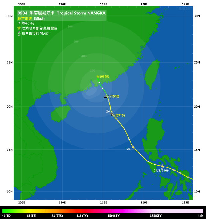
IR imagery animation 紅外線雲圖動畫:
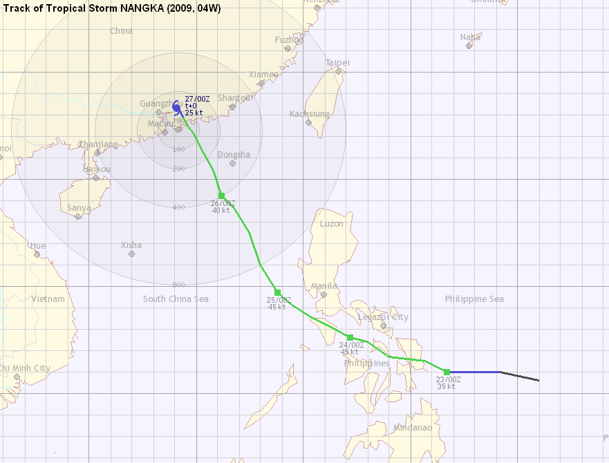
TC track from HKWW 本站的熱帶氣旋路徑圖:
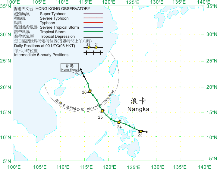
TC tracks from HKO 天文台的熱帶氣旋路徑圖:
| Past HKWW Bulletins on NANGKA 本站有關浪卡的發佈 |
Please click here for bulletins on NANGKA. 請按這裡。
| Storm Formation and Development 氣旋形成和發展 |
Just as LINFA landed in Fujian Province, another persisting tropical disturbance to the east of the Philippines (92W) quickly consolidated, and the JTWC upgraded that disturbance into a FAIR area, issued a Tropical Cyclone Formation Alert and promoted it to tropical depression 04W all within one day - June 22nd. At the time of formation, the subtropical ridge dominated the area north of the system, and extended west to approximately 117°E. Numerical models generally predicted a retreat of the ridge later due to the influence of a mid-latitude trough, and thus JTWC's initial forecast favoured a recurving scenario that would take place as soon as the storm reached 120°E. Meanwhile, the HKO upgraded the system to tropical depression status at 08 HKT on the next day as NANGKA's structure improved.
As the steering subtropical ridge was strong, 04W moved westwards quickly and made its first landfall at Samar Island in the afternoon (June 23rd). The JMA upgraded this cyclone into a tropical storm and it was named NANGKA, which was contributed by Malaysia meaning "Jackfruit", a oval-shaped fruit popular in the country.
At this point, almost all agencies were predicting a gradual intensification of the system. However, as they expected NANGKA to make landfall many times near the Philippines, intensification was expected to be somewhat slower.
正當熱帶氣旋蓮花登陸福建,另一股於菲律賓以東海域醞釀的熱帶擾動 92W 開始整固。JTWC 於 6 月 22 日先後把該擾動提升為 FAIR 和 GOOD 評級,並於晚上把其升格為熱帶低氣壓 04W。在 04W 形成初期,副熱帶高壓脊正處於該系統的北面,其西面延伸達東經 117 度。大部分的數值預報模式均指西風槽將於稍後橫過,並令副高減弱,因而 JTWC 首報認為 04W 將於到達東經 120 度附近時轉向。另外,隨著 04W 組織變好,香港天文台於 23 日上午 8 時把 04W 升格為熱帶低氣壓。
由於駛流明顯,04W 快速向西移動,在 23 日下午於菲律賓東部薩馬島首次登陸。日本氣象廳將其升格為熱帶風暴,並命名為浪卡。浪卡是馬來西亞提供的名字,為當地一種黃色橢圓形的水果。
此時,幾乎所有官方機構均認為浪卡將逐漸增強;但由於將經歷多次登陸,增強幅度並不大。

Figure 1 - Track map from JTWC at 20 HKT on June 22nd
圖 1 - JTWC 於 6 月 22 日晚上 8 時之發佈

Figure 2 - Image of 04W at 14:30 HKT on June 22nd
圖 2 - 04W 於 6 月 22 日下午 2 時 30 分的衛星影像

Figure 3 - Track map from JMA at 14 HKT on June 23rd
圖 3 - 日本氣象廳於 6 月 23 日下午 2 時之發佈

Figure 4 - Steering chart, 14 HKT on June 23rd
圖 4 - 6 月 23 日下午 2 時的駛流圖

Figure 5 - Forecast tracks from different agencies, 20 HKT on June 23rd
圖 5 - 各站於 6 月 23 日晚上 8 時之預測路徑圖
| NANGKA in the Philippines and South China Sea 浪卡經過菲律賓並進入南海 |
Strong convections were seen as NANGKA travelled within the Philippines. However it did not utilize the favourable environment in the central Philippines (primarily the super-warm sea) and failed to pack those convective clouds tightly.
As with other storms, NANGKA chose the path with the least resistance and veered away from most landmasses and mountains except Mindoro. NANGKA moved out of Mindoro and entered the South China Sea just one day later (June 24th), but the environment their was anything but favourable due to the strong shear between the lower level southwest monsoon and the upper level highs that provided easterly winds.
浪卡橫過菲律賓時曾多次出現對流爆發,但它並未能利用菲律賓中部島嶼間良好的水溫作出增強。
跟以往氣旋一樣,浪卡採取最少阻力的路徑,除民都洛島外避過大部分島嶼。浪卡於 24 日移離民都洛並進入南海,但當時南海低層受強勁西南季候風影響,垂直風切變甚高,浪卡的前景並不樂觀。

Figure 6 - IR image showing NANGKA at 12 HKT on June 24th
圖 6 - 6 月 24 日中午 12 時之紅外線衛星雲圖

Figure 7 - Wind shear chart, 14 HKT on June 24th
圖 7 - 6 月 24 日下午 2 時之垂直風切變分布圖
NANGKA's low-level circulation centre (LLCC) was therefore sheared to the northeast, and the upper-level cloud bands remained southwest of the LLCC. As the ridge weakened as predicted, NANGKA started to turn to a NNW movement. The storm, however, did not exhibit an abrupt turn, and agencies therefore revised their forecast tracks westward to predict a landfall in eastern Guangdong.
Due to the strong shear, not only that NANGKA was unable to gain strength, it even weakened as it travelled north. The LLCC has been terribly exposed since June 25th and at one point the pack of clouds, as seen from sateliite images, was no different from a FAIR or GOOD area (in JTWC standard).
The ridge then completed its change in orientation to north-south and the storm moved rapidly N to NNW. It entered the 800 km circle near 14 HKT on June 25th, but it seemed that future uncertainty in its movement and its relatively weak appearance prompted HKO not to issue the Standby Signal at this point.
浪卡的低層環流中心因而脫離其主對流群,向東北方向切離;而高層雲團則持續於低層環流中心之西南面。比預計強的副高開始減弱,浪卡亦開始向西北偏北移動,但幅度並未如官方機構預測之大。各台均對它們的預測路徑作出修改,並預料浪卡將於廣東東部登陸。
由於對流持續切離,浪卡不但未能於北上期間增強,更開始逐漸減弱。自 25 日開始其低層環流中心暴露情況變得非常嚴重;其雲團形狀跟一般的 FAIR 或 GOOD 擾動無異 (見圖 8)。
副高逐漸改為南北向,浪卡繼而向北至西北偏北快速移動。它於 25 日下午約 2 時進入本港 800 公里範圍,但可能由於其移動方向並未明朗,且強度偏弱,令天文台不即時發出一號信號。

Figure 8 - IR image showing NANGKA at 20 HKT on June 25th. NANGKA's convective clouds remained in the southern quadrant and failed to wrap around the centre.
圖 8 - 6 月 25 日晚上 8 時之紅外線衛星雲圖。浪卡的雲團集中於其南面

Figure 9 - Forecast tracks from different agencies, 17 HKT on June 25th
圖 9 - 各站於 6 月 25 日下午 5 時之預測路徑圖
| Signals in Hong Kong and NANGKA's Final Landfall 香港發出之熱帶氣旋警告信號和浪卡的最後一次登陸 |
NANGKA veered heavily to the west in the night of June 25th, and was already near 116°E by dawn the next day. The Observatory issued the #1 Standby Signal at 07:15 HKT (on June 26th) but later added that a change in signal before early afternoon was unlikely. It also mentioned that NANGKA would pass within 200 kilometres of Hong Kong, which was reasonable as this could be achieved even if NANGKA was to travel straight north from that point.
Locally, the weather became unstable on June 26th with some showers and alternating sunny and cloudy periods. As NANGKA continued to travel NNW without significant signs of weakening (it was quite weak at that point anyway), the Observatory issued the #3 Strong Wind Signal at 15:40 HKT. It added that unless NANGKA strengthened or the track was changed significantly, the chance for higher signals was not high.
浪卡於 25 日晚西移分量短暫增加,於翌日 (26 日) 清晨已達東經 116 度附近。天文台於 26 日上午 7 時 15 分發出一號戒備信號,但稍後指中午初期前改發更高信號的可能性不大。天文台亦指出浪卡將於稍後於香港 200 公里範圍內掠過。由於浪卡比預期西,此為合理的預測。
本港天氣於 26 日開始變得不穩定,晴陰間斷出現。隨著浪卡繼續向西北偏北移動,且無明顯減弱,天文台於下午 3 時 40 分發出三號強風信號,並說除非浪卡增強或移動路徑大幅改變,否則發出更高信號的機會不大。

Figure 10 - Image of NANGKA at 15:30 HKT on June 26th. The low-level circulation centre was fully exposed.
圖 10 - 6 月 26 日下午 3 時 30 分的影像。浪卡的低層環流中心完全外露
Winds did not strengthen appreciably after the Strong Wind Signal came into effect, but due to the storm most places saw a wind direction changing to NE. As NANGKA's cloudbands were confined to its southern periphery, Hong Kong experienced a relatively calm "Strong Wind Signal" night. NANGKA entered the 100 km circle near 20 HKT on June 26th. The Observatory downgraded NANGKA into a tropical depression at 21 HKT, ruling out the possibility of any higher signals. NANGKA finally made landfall at about midnight (June 27th) near Daya Bay, just 60 kilometres ENE of the Observatory. Wind direction turned counterclockwise and by midnight most places were blowing northwesterly winds.
三號信號發出後本地風勢並沒有明顯增強,但風向已逐漸轉向東北。由於浪卡的雨帶集中在其低層環流中心以南,本港當晚相對寧靜,風勢雨勢皆頗弱。浪卡於 26 日晚上 8 時左右進入香港 100 公里範圍。天文台於晚上 9 時將浪卡降格為熱帶低氣壓;這暗示八號信號已經無需發出。浪卡最終於 27 日近凌晨時份於香港天文台東北偏東 60 公里處,即大亞灣附近登陸。本港風向即由東北轉向西北。


Figures 11a to 11d - Wind directions across Hong Kong at 16, 20, 00, 04 HKT on June 26th/27th
圖 11a 至 11d - 6 月 26/27 日香港時間 16、20、00 和 04 時的風向風速圖


Figures 12a to 12d - Radar images at 20, 22, 00, 02 HKT on June 26th/27th
圖 12a 至 12d - 6 月 26/27 日香港時間 20、22、00 和 02 時的雷達圖

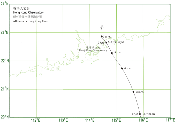
Figure 13 - Track of NANGKA in the vicinity of Hong Kong. Image from HKO.
圖 13 - 香港天文台於浪卡靠近香港時發出的預測路徑圖
| Rapid Weakening and Subsequent Downpours 急速減弱和隨後的大雨 |
Throughout the night winds were light, with only stations on high grounds and near offshore waters like Tate's Cairn, Waglan Island and Tap Mun recorded strong winds. As NANGKA made landfall it continued to weaken and move deeper inland. Rainbands associated with NANGKA started to affect Hong Kong in the small hours of June 27th.
The Observatory cancelled all signals at 05:25 HKT as winds across the territory died out. Later in the hour, it downgraded NANGKA into an area of low pressure as it continued to weaken. However the most intense rainbands started to affect the territory, and the weather on June 27th remained overcast with heavy rains at times. The Observatory issued the Strong Monsoon Signal at 11:40 HKT as induced SW monsoon started to dominate. Heavy rains continued on June 28th, and the weather gradually improved on June 29th.
本港整晚風勢較弱,只有離岸和高地氣象站如大老山、橫欄島和塔門曾錄得持續強風。浪卡登陸後繼續移入內陸,並逐漸減弱。伴隨浪卡的雨帶於 27 日首數小時開始影響本港。
由於風勢開始減弱,天文台於當天上午 5 時 25 分取消所有信號,並於該小時後期把浪卡降格為低壓區。但浪卡最強的雨帶開始影響香港,本地當天整日天陰,間中有大雨。天文台於上午 11 時 40 分發出強烈季候風信號,提醒市民由浪卡引進的西南氣流將會本港帶來強風。大雨於 28 日持續,本港天氣於 29 日才逐漸轉好。


Figures 14a to 14c - Daily isohyet charts from June 26th to June 28th
圖 14a 至 14c - 6 月 26 至 28 日的每天等雨量線圖
| Resemblance to FENGSHEN 與風神近似的地方 |
NANGKA shared quite a number of similarities with Typhoon FENGSHEN, which brought the first #8 Gale or Storm Signal to Hong Kong last year (2008). Those similarities include:
- Track similarity - both storms moved west quickly into the Philippines and moved NNW in South China Sea, making landfall very close to Hong Kong;
- Time of the year - both storms were formed in the latter half of June;
- Failure in track prediction - almost all numerical forecasts and official agencies overestimated the degree of recurvature of both systems, and westward adjustments were made almost bulletin by bulletin.
- Vertical wind shear (VWS) in South China Sea - VWS was high while both storms were travelling in the South China Sea. Displacement of the main patch of convection to the south (or southwest) of the low-level circulation centre was evident in both cases.
The only difference seemed to be storm strength - FENGSHEN was once a category 3 typhoon in the Philippines, but NANGKA was only a tropical storm. However, the most eye-catching similarity is that both storms proved to be challenging for forecasters. Some attributed the longer-than-expected westward component to the continually sheared main convections, while some focused on a tendency for numerical models to have northward bias in their track prediction. One conclusion we can make though, is that forecasting recurving system is always a tough job due to its inherent uncertainty (forecasting some configurations to alter so as to induce a change in the track) and is subject to large errors.
浪卡與上年令天文台發出首個八號信號的熱帶氣旋風神頗為類似,如下列數項:
- 路徑相似性 - 浪卡和風神皆向西快速移動,趨向菲律賓;其後進入南海並一直向西北偏北移動,於香港附近登陸;
- 時間 - 兩個熱帶氣旋均於 6 月下旬形成;
- 路徑預測 - 幾乎所有預測模式同樣指該兩個風暴將大幅轉向,但並未能實現;由於副高比預期強,幾乎每報預測路徑均作出西移;
- 南海的垂直風切變皆頗高,令雲團向西南面切離。
似乎唯一的分別為熱帶氣旋強度:風神曾為一三級颱風,但浪卡最強時只為熱帶風暴。最觸目的近似處為兩個風暴皆令預報員大跌眼鏡。有些分析指由於主要雲團向西切離,最終令風暴路徑偏西;另一些則指數值模式對於此類風暴的預測往往有過分偏北的成分。但總括來說,預測轉向的熱帶氣旋將繼續是預報員的一大難題,主要由於其本身的不確定性甚高 (要預測一些配置改變從而令風暴轉向;而非預測某配置維持原狀);得出的預測誤差將無可避免地大。

Figure 15 - Tracks of FENGSHEN and NANGKA overlaid on each other. The track that emerged from the Philippines near 16°N belongs to FENGSHEN, while the one that emerged near 14°N belongs to NANGKA.
圖 15 - 風神疊加在浪卡的路徑圖。風神於約北緯 16 度離開菲律賓,而浪卡則於約北緯 14 度離開菲律賓
| Winds Recorded at Reference Stations 參考站所錄得的風速 |
| Station 風速站 |
Max. 10-min avg. wind speed 最高十分鐘平均風速 |
Beaufort classification 蒲福氏風級分類 |
| Chek Lap Kok 赤鱲角 | 38 km/h | Fresh 清勁 |
| Cheung Chau 長洲 | 40 km/h | Fresh 清勁 |
| Kai Tak 啟德 | 36 km/h | Fresh 清勁 |
| Sai Kung 西貢 | 39 km/h | Fresh 清勁 |
| Sha Tin 沙田 | 21 km/h | Moderate 和緩 |
| Ta Kwu Ling 打鼓嶺 | 27 km/h | Moderate 和緩 |
| Tsing Yi (SHL) 青衣蜆殼油庫 | 22 km/h | Moderate 和緩 |
| Wetland Park 濕地公園 | 22 km/h | Moderate 和緩 |
| Number of stations recording at least STRONG force (force 6 - 7) winds: | 0 |
Number of stations recording at least GALE force (force 8 - 9) winds: |
0 |
| Number of stations recording at least STORM force (force 10 - 11) winds: | 0 |
| Number of stations recording HURRICANE force (force 12) winds: | 0 |
| 錄得 強風 (6 - 7 級) 或更高風速的站數: | 0 |
| 錄得 烈風 (8 - 9 級) 或更高風速的站數: | 0 |
| 錄得 暴風 (10 - 11 級) 或更高風速的站數: | 0 |
| 錄得 颶風 (12 級) 風速的站數: | 0 |
| Charts and Figures 各項數據 |
Table 1: Track data from HKWW:
表一 : 香港天氣觀測站之路徑資料
YYMMDDZZ Lat Long Wind |
Table 2: Maximum gust and 60-minute average wind speed recorded in Hong Kong from HKO:
表二 : 香港天文台公佈的各站最高 60 分鐘平均風力和陣風數據
Maximum Gust |
Maximum Hourly Wind |
|||||||
Station |
Direction |
Speed (km/h) |
Date/Month |
Time |
Direction |
Speed (km/h) |
Date/Month |
Time |
Bluff Head (Stanley) |
ENE |
62 |
26/6 |
14:16 |
E |
30 |
26/6 |
15:00 |
Central Pier |
E |
56 |
26/6 |
11:41 |
E |
30 |
26/6 |
16:00 |
Cheung Chau |
E |
58 |
26/6 |
12:03 |
E |
31 |
26/6 |
15:00 |
Hong Kong International Airport |
ESE |
51 |
26/6 |
14:48 |
NW |
31 |
27/6 |
00:00 |
Kai Tak |
NE |
62 |
26/6 |
12:00 |
W |
25 |
26/6 |
23:00 |
King's Park |
ESE |
47 |
26/6 |
12:17 |
ENE |
16 |
26/6 |
18:00 |
Lau Fau Shan |
WNW |
49 |
27/6 |
02:08 |
WNW |
31 |
27/6 |
02:00 |
|
|
|
|
|
WNW |
31 |
27/6 |
03:00 |
Ngong Ping |
E |
83 |
26/6 |
15:38 |
E |
59 |
26/6 |
13:00 |
North Point |
E |
63 |
26/6 |
18:01 |
E |
27 |
26/6 |
15:00 |
|
|
|
|
|
W |
27 |
27/6 |
01:00 |
|
|
|
|
|
W |
27 |
27/6 |
02:00 |
Peng Chau |
E |
63 |
26/6 |
12:29 |
NW |
38 |
27/6 |
00:00 |
Ping Chau |
E |
68 |
26/6 |
14:43 |
W |
31 |
27/6 |
02:00 |
Sai Kung |
ENE |
65 |
26/6 |
17:55 |
ENE |
30 |
26/6 |
12:00 |
|
|
|
|
|
NE |
30 |
26/6 |
17:00 |
Sha Chau |
ENE |
56 |
26/6 |
12:43 |
N |
25 |
26/6 |
21:00 |
Sha Lo Wan |
E |
56 |
26/6 |
12:47 |
E |
30 |
26/6 |
13:00 |
Sha Tin |
E |
47 |
26/6 |
16:09 |
NE |
19 |
26/6 |
16:00 |
Shek Kong |
E |
49 |
26/6 |
12:22 |
E |
19 |
26/6 |
15:00 |
Star Ferry (Kowloon) |
SE |
56 |
26/6 |
12:15 |
WNW |
30 |
27/6 |
00:00 |
Ta Kwu Ling |
E |
49 |
26/6 |
15:39 |
E |
19 |
26/6 |
16:00 |
Tai Mei Tuk |
E |
79 |
26/6 |
18:05 |
NE |
38 |
26/6 |
19:00 |
Tai Mo Shan |
E |
77 |
26/6 |
15:19 |
W |
54 |
27/6 |
03:00 |
Tap Mun |
WNW |
70 |
26/6 |
22:55 |
W |
40 |
27/6 |
00:00 |
Tate's Cairn |
E |
83 |
26/6 |
16:37 |
E |
51 |
26/6 |
17:00 |
Tsak Yue Wu |
NE |
41 |
26/6 |
14:50 |
N |
14 |
26/6 |
21:00 |
Tseung Kwan O |
NE |
43 |
26/6 |
17:54 |
NNE |
16 |
26/6 |
18:00 |
Tsing Yi Shell Oil Depot |
ESE |
38 |
26/6 |
12:08 |
NNW |
14 |
26/6 |
22:00 |
|
|
|
|
|
NW |
14 |
26/6 |
23:00 |
|
|
|
|
|
NW |
14 |
27/6 |
00:00 |
Tuen Mun Government Offices |
WNW |
49 |
27/6 |
03:21 |
WNW |
14 |
27/6 |
04:00 |
Waglan Island |
ENE |
75 |
26/6 |
12:15 |
ENE |
52 |
26/6 |
18:00 |
Wetland Park |
WNW |
36 |
26/6 |
23:57 |
NW |
19 |
26/6 |
23:00 |
Wong Chuk Hang |
SE |
54 |
26/6 |
15:02 |
E |
23 |
26/6 |
15:00 |
Table 3: Rainfall contributed by NANGKA from HKO (figures in brackets are based on incomplete hourly data):
表三 : 香港天文台公佈的各站雨量資料 (方括號內之數據由不完整之每小時資料擷取)
| Station | 26-June | 27-June | Total | |
| Hong Kong Observatory | 17.7 |
46.9 |
64.6 |
|
| Cheung Chau (CCH) | 3.5 |
38.0 |
41.5 |
|
| Hong Kong International Airport (HKA) | 5.9 |
14.7 |
20.6 |
|
| N05 | Fanling | 7.5 |
32.0 |
39.5 |
| N13 | High Island | 26.0 |
71.0 |
97.0 |
| K04 | Jordan Valley | 20.0 |
45.5 |
65.5 |
| N06 | Kwai Chung | 16.5 |
51.0 |
67.5 |
| H12 | Mid Levels | 18.0 |
43.5 |
61.5 |
| H21 | Repulse Bay | 32.5 |
51.5 |
84.0 |
| N09 | Sha Tin | 16.0 |
51.0 |
67.0 |
| H19 | Shau Kei Wan | 20.5 |
51.5 |
72.0 |
| SEK | Shek Kong | 11.5 |
23.5 |
35.0 |
| K06 | So Uk Estate | 19.5 |
60.5 |
80.0 |
| PLC | Tai Mei Tuk | 16.5 |
[42.5] |
[59.0] |
| R21 | Tap Shek Kok | 4.5 |
7.0 |
11.5 |
| N17 | Tung Chung | 4.0 |
[34.0] |
[38.0] |
| R27 | Yuen Long | 6.5 |
14.5 |
21.0 |
Last Accessed 最近訪問日期: Thu May 16 2024 01:36:45 HKT
Last Modified 最近修訂日期: Mon Jul 24 2023
